
Washington / Pacific Northwest
South Fork Snoqualmie River
A lower South Fork report focused on North Bend public-access planning, the 12144000 town gauge, and realistic warm-season trout judgment.
Image: Generated lower South Fork Snoqualmie planning image / BlueStreamFly generated; not exact location / BlueStreamFlyFishability now: South Fork Snoqualmie River fishability today
GreatData confidence: High96/100
Fishable now because NORTH BEND WA gauge is stable, weather is mild, and no public alert is active.
Flow observed
4:45 PM UTC
Weather observed
5:00 PM UTC
Score calculated
5:26 PM UTC
Why this rating
Flow
Weather
Public alerts
Next 6-12 hours
Hold
Stable live data supports staying with the plan, but recheck the gauge and forecast before leaving.
USGS flow
276 cfs
Current trend: flow stable, so weather, temperature, and access checks drive the next change.
More planning details: flies, flow bands, and live source checks
Fish it today
Start here
Base in North Bend, check the gauge and temperature early, fish one public corridor stretch, and leave when conditions flatten out.
Best flow clue
Best on moderate clear flows with clean bank seams and cool temperatures. Warm low flow is the main trap here.
Skip trigger
Skip when summer warmth, muddy floodplain water, or crowding turn convenience into poor fish handling.
Flow decision bands
Moderate clear North Bend flow
This is the best short-session signal when bank seams, tailouts, and public edges are readable and cool enough for trout.
Dropping green shoulder-season water
Can be useful if exits and footing stay obvious and emergency-rule checks are current.
Low warm valley flow
Fish early, check temperature, shorten handling, or move upstream to colder water.
Floodplain push, mud, or woody edges
A clear skip signal for town-edge wading even when parking is easy.
USGS flow
276 cfs
Current trend: flow stable, so weather, temperature, and access checks drive the next change.
Live USGS flow
276 cfs / stable
Live NWS forecast
62F / Mostly Cloudy
Water temperature not verified
Heat guidance uses weather and river type unless an official water-temperature value is available.
No NWS alert flag
No active NWS alert was returned for this forecast point.
North Bend’s parks and trails network makes this lower reach a true town-access route rather than an upstream forest corridor.
North Bend’s parks and shoreline-planning pages are the clearest official anchors for planning public access near town.
This reach loses value quickly when summer temperatures climb or the valley gets crowded.
The town gauge is the right signal for whether the lower South Fork is still a clean wading choice.
Editorial review
How this report is maintained
This report starts with official regulation, access, flow, weather, and public-land sources, then adds practical planning guidance for fly anglers.
Byline
BlueStreamFly editorial desk
Reviewed by
BlueStreamFly source review
Maintained by
BlueStreamFly
Last material review
2026-06-03
Report confidence
Good confidence
89/100
Good confidence: RiverReports, USGS 12144000 at North Bend, WDFW regulation and emergency-rule sources, North Bend shoreline and park access sources, weather data, and route-specific lower South Fork guidance support the page. Confidence is moderated by emergency-rule changes, warm valley water, crowding, soft banks, woody floodplain edges, and reach-to-reach differences from Garcia.
Regulations
WDFW regulations and emergency-rule sources support current legal and closure checks.
Access
North Bend shoreline and parks sources support public access planning, with exact bank, trail, and crowding conditions still requiring current checks.
Flow and weather
RiverReports, USGS 12144000 at North Bend, and the National Weather Service point support live flow and weather decisions.
Fishing usefulness
The page now separates North Bend flow, town-edge access, warm-water restraint, public-edge crowding, floodplain skips, emergency-rule checks, and Snoqualmie backup choices.
Fishability dashboard and source review
2026-06-03 / material content or source review
RiverReports, USGS 12144000 at North Bend, Washington regulations and emergency-rule sources, North Bend public shoreline and parks sources, National Weather Service point data, and route-specific lower South Fork trout safety guidance were checked before updating the current-fishability decision layer.
2026-06-03
Updated South Fork Snoqualmie River at North Bend to the current fishability-page standard with North Bend flow bands, town-edge access cards, warm-water and crowding backup cues, stable fishability SEO, and confidence signals.
2026-05-28
Published a new North Bend reach report with town-edge access guidance, lower-valley flow framing, and warm-weather restraint notes.
Angler planning edge
Local details that change the plan
Best for
quick public-access trout sessions, cool-morning town fishing, lower-valley scouting before driving upstream
Wade or float
This is a wade-first public-access reach. The value is short bank-and-seam fishing, not trying to cover big water.
Best flows
Best on moderate clear flows with clean bank seams and cool temperatures. Warm low flow is the main trap here.
When to skip
Skip when summer warmth, muddy floodplain water, or crowding turn convenience into poor fish handling.
Local plan
Base in North Bend, check the gauge and temperature early, fish one public corridor stretch, and leave when conditions flatten out.
Pressure
The public edges near town are the most likely to see dog walkers, families, and other anglers, especially on weekends.
Access nuance
City and park planning improves access, but it also concentrates use. Fish lightly and do not assume every green edge is stable.
Backup water
Move to Garcia for colder upstream water or to the Middle Fork if you want a broader public-land mountain option.
About the river
Setting, character, and why it fishes the way it does.
The South Fork near North Bend is a different fishing proposition from the upstream Garcia corridor. It is broader, easier to scout, and more tied to municipal parks, trail links, and quick access from town.
That accessibility is helpful, but it also changes the ethics and the tactics. Warm-season temperature, crowding, and bank impact matter more here than in the colder canyon reach upstream.
For BlueStreamFly readers, this route is the one to use when you want a compact public-access trout session near town and are willing to stop the moment conditions say the river is off.
Target species
Coastal cutthroat trout
The best fit for lighter warm-season trout planning on the lower South Fork.
Resident trout
A realistic target in cooler windows when current seams stay defined.
Whitefish
A shoulder-season backup when trout are less active or the river stays cold.
Warm-weather stress context
An important planning category because this lower reach can lose trout value before it looks dramatic from the bank.
Reading the water
Moderate clear flow
Best for short wades, pocket transitions, and dry-dropper scouting.
Low warm flow
A warning sign to fish early, check temperature, or move elsewhere.
Dropping green water
A good shoulder-season condition if exits and footing stay obvious.
Floodplain push
Skip the wade plan if woody edges or soft banks are moving around.
Best seasons
Spring
Good if runoff stays controlled and the river clears into readable seams.
Early summer
Often the best mix of accessibility and trout-friendly water temperature.
Early fall
Strong for cooler mornings and quick public-access sessions after summer heat breaks.
Winter
Selective and mostly about safe short sessions, not all-day wading.
Preferred flow source
SF SNOQUALMIE RIVER AT NORTH BEND WA
RiverReports is the preferred chart source when coverage exists. When a matching USGS gauge exists, keep it open as the official backstop for station data and current hydrograph context.
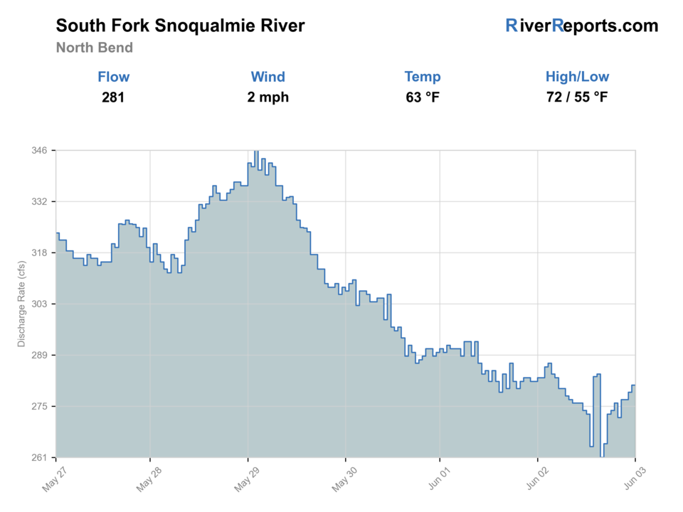
USGS data chart
Official USGS trend
Streamflow over the latest USGS reporting window.
Latest
276 cfs
Jun 3, 4 PM UTC
Weather
River weather report
Weather can change wading safety, road access, water temperature, hatches, and the best time of day to fish.
Live forecast loads as you reach this section
This keeps the report fast while still using the official National Weather Service forecast point.
Hatches and flies
Hatch chart and fly picks
Late winter to spring
Midges, stoneflies, and early caddis in cold clear windows
Stonefly nymph, zebra midge, olive bugger, caddis pupa
Summer
Caddis, pale mayflies, and terrestrials around shaded banks and gravel edges
Elk hair caddis, Adams, beetle, ant, perdigon
Early fall
Caddis and opportunistic baitfish windows around migrating salmon traffic
Sculpin streamer, caddis dry, egg imitation where legal and ethical
Late fall to winter
Sparse insect life and short cold-water feeding windows
Leech, stonefly nymph, egg pattern, small intruder-style swing fly
Trout and resident-fish flies
Pheasant tail, hare's ear, perdigon, caddis pupa, Adams
Good for low clear summer days and shoulder-season pocket water.
Light streamer support
Olive bugger, sculpin, sparse leech, minnow pattern
Useful after rain bumps or where wood and deeper slots hold better fish.
Seasonal salmonid support
Egg pattern, stonefly, soft hackle, sparse marabou
Carry them only when current regulations and fish handling support the plan.
Tactics
How to fish it
Treat the North Bend reach as a one-or-two-stop river and fish those access points carefully.
Cover softer edges, bank seams, and tailouts before working the middle of the current.
If water temperature feels borderline, stop early rather than forcing an easy-access day.
Use the lower South Fork when you want efficient public access, not when you want remote solitude.
Rigging
Rod, leader, and setup notes
A 4- or 5-weight with a dry-dropper or light nymph rig is the cleanest default for this reach.
Carry a small streamer for woody edges and deeper buckets after rain bumps.
Long leaders help in low clear water, but only if you can still turn fish quickly and keep drifts accurate.
Access
Access and planning notes
Dahlgren and Tanner Landing corridor
Primary town-access startWade / float / trail
Public corridor / bank / short wade
When to pick it
Start here when the North Bend gauge, temperature, and crowding support a short responsible session.
Caution
Town access concentrates use and can create soft-bank impact quickly.
Riverfront Park corridor
Quick conditions and bank-seam checkWade / float / trail
Park / shoreline / short wade
When to pick it
Use it when you need a compact public check before deciding whether to fish or move upstream.
Caution
Parks can be busy and easy entry is not the same as safe footing.
North Bend parks and shoreline network
Public-access frameworkWade / float / trail
Parks / trails / bank
When to pick it
Pick another public edge only when it clearly improves flow, crowding, or exit options.
Caution
Do not assume every green edge is public, stable, or appropriate to fish.
Use the city parks page and shoreline access plan together when deciding which public edge is actually worth starting from.
Park access near town is easier than the Garcia reach, but easier access usually means more pressure and more impact.
Soft banks and woody floodplain edges make some easy-looking exits unreliable after rain.
Regulations
Check before fishing
Check Washington fishing regulations and emergency changes before fishing because this basin’s open periods and trout handling rules are not static.
Primary base
North Bend, Washington
Best day style
Town-edge shoreline planning, parks, trail connectors, and short public-access wades
Check first
Washington regulations, emergency changes, the 12144000 trend, North Bend shoreline access notes, and river temperature
Safety
Fast floodplain current, soft banks, woody edges, and summer warmth that can turn a convenient stop into a bad trout day
Gear
Helpful gear for this water
4- to 6-weight rod
A 5-weight covers the broadest mix of small streamers, dry-dropper rigs, and quick wading adjustments.
Wading staff
Worth carrying on slick cobble, woody edges, and fast knee-deep slots that look easier than they are.
Rain shell
A clear mountain morning can still turn into a cold wet exit by afternoon.
Thermometer
Useful on lower reaches and warm spells when responsible trout handling changes the plan.
Nearby water
Other water to research
Backup logic
Warm trout water
Move to the Garcia reach or Middle Fork for colder public-water options.
Muddy or floodplain push
Wait for the North Bend graph to settle before using town-edge banks.
Crowded public edges
Shorten the session or move upstream rather than pressing tight city access.
Emergency-rule uncertainty
Recheck WDFW regulations and emergency changes before choosing tackle or target species.
Middle Fork Snoqualmie River
A colder mountain-river alternative with broader Forest Service access.
Cedar River at Renton
A lower-elevation urban-river alternative when you still want a short public-access day.
South Fork Snoqualmie River Garcia
The upstream colder-corridor version of this river when town water feels too warm or crowded.
FAQ
Fast answers
Is South Fork Snoqualmie River fishable today?
South Fork Snoqualmie River looks very fishable right now. The live score is 96/100, based on current flow, weather, public alerts, and the report's planning context. Recheck the linked gauge and forecast before leaving because conditions can change quickly after rain, heat, access changes, or flow swings.
What flow is best for South Fork Snoqualmie River?
Best on moderate clear flows with clean bank seams and cool temperatures. Warm low flow is the main trap here.
When should I skip South Fork Snoqualmie River?
Skip when summer warmth, muddy floodplain water, or crowding turn convenience into poor fish handling.
Is South Fork Snoqualmie River safe to wade right now?
The fishability score is not a wading guarantee. Wade only where your chosen access has safe edges, clear footing, legal entry, and no forced crossings; high, rising, stained, or storm-affected water should be treated conservatively.
Where should I start on the South Fork near North Bend?
Start with the Dahlgren and Tanner Landing public corridor and fish one compact stretch well instead of wandering the whole valley.
How is the North Bend reach different from Garcia?
North Bend is the lower town-edge public-access reach tied to the 12144000 gauge, while Garcia is the colder upstream canyon-style corridor.
When should I skip the North Bend reach?
Skip when water temperature is rising, the gauge shows floodplain-style push, or the public edges are too crowded to fish responsibly.
Sources
Source set for this report
Reviewed 2026-06-03