
Washington / Pacific Northwest
South Fork Snoqualmie River
An upstream South Fork Snoqualmie report centered on the Garcia gauge, Tinkham corridor access, and conservative small-river judgment above the town reach.
Image: Generated upper South Fork Snoqualmie planning image / BlueStreamFly generated; not exact location / BlueStreamFlyFishability now: South Fork Snoqualmie River fishability today
GreatData confidence: High96/100
Fishable now because the live gauge is stable, weather is mild, and no public alert is active.
Flow observed
5:15 PM UTC
Weather observed
5:00 PM UTC
Score calculated
5:26 PM UTC
Why this rating
Flow
Weather
Public alerts
Next 6-12 hours
Hold
Stable live data supports staying with the plan, but recheck the gauge and forecast before leaving.
USGS flow
77 cfs
Current trend: flow stable, so weather, temperature, and access checks drive the next change.
More planning details: flies, flow bands, and live source checks
Fish it today
Start here
Check the Garcia gauge, use Olallie or the Wagon Road/Tinkham corridor as the access frame, and fish the first safe stretch thoroughly.
Best flow clue
Use the Garcia gauge with trail and corridor access. Stable or gently falling water with clear edges is the best signal.
Skip trigger
Skip when runoff, rain, wood, poor visibility, or canyon current makes every pocket feel rushed before you rig.
Flow decision bands
Stable Garcia flow
Stable or slowly falling USGS 12143400 flow with visible edges is the best upper South Fork signal.
Best pocket-water window
Cool weather, clear seams, safe exits, and confirmed public access make a short session most useful.
Runoff or rain rise
Rising flow, moving wood, or poor visibility should move the plan lower or out of the canyon.
Canyon exit problem
If every step lacks a clean exit, the route is not worth fishing even if the gauge looks plausible.
USGS flow
77 cfs
Current trend: flow stable, so weather, temperature, and access checks drive the next change.
Live USGS flow
77 cfs / stable
Live NWS forecast
58F / Mostly Cloudy
Water temperature not verified
Heat guidance uses weather and river type unless an official water-temperature value is available.
No NWS alert flag
No active NWS alert was returned for this forecast point.
Olallie State Park and the Wagon Road corridor give this upstream page a real park-and-forest access identity instead of a town-edge shoreline feel.
The Garcia gauge is the better reference for whether the upper South Fork still has manageable edges above the lower North Bend floodplain.
Cold clear days reward compact dry-dropper or nymph plans more than hero casts.
If the river is rising or wood is moving, this reach loses value fast.
Editorial review
How this report is maintained
This report starts with official regulation, access, flow, weather, and public-land sources, then adds practical planning guidance for fly anglers.
Byline
BlueStreamFly editorial desk
Reviewed by
BlueStreamFly source review
Maintained by
BlueStreamFly
Last material review
2026-06-02
Report confidence
High confidence
87/100
High confidence: RiverReports, USGS Garcia flow, Washington regulations and Snoqualmie emergency-rule context, Olallie State Park, Wagon Road Trail, Tinkham corridor context, weather coverage, image disclosure, and route-specific upper-valley guidance support the page. Confidence is moderated by runoff, canyon exits, wood, pullout legality, cold pocket water, and fast weather changes.
Regulations
Washington sport-fishing and Snoqualmie emergency-rule sources support the legal-check path.
Access
Olallie State Park and Wagon Road Trail sources support the public access framework, with individual pullouts and current signs still needing confirmation.
Flow and weather
RiverReports coverage is backed by USGS 12143400 above Alice Creek near Garcia, and the National Weather Service point supports weather and safety decisions.
Fishing usefulness
The page now separates Garcia flow, state park and trail access, runoff, wood, canyon exits, upper-versus-lower South Fork choices, and backup-water decisions.
Fishability dashboard and source review
2026-06-02 / material content or source review
RiverReports, USGS 12143400 above Alice Creek near Garcia, Washington sport-fishing and Snoqualmie emergency-rule sources, Olallie State Park, Wagon Road Trail, Tinkham corridor context, National Weather Service data, and image-disclosure sources were checked before updating the current-fishability decision layer.
2026-06-02
Updated South Fork Snoqualmie River at Garcia to the current fishability-page standard with Garcia trend bands, Olallie and Wagon Road access cards, runoff and canyon-exit skip cues, backup logic, stable fishability SEO, and confidence signals.
2026-05-28
Published a new Garcia reach report with gauge-backed flow guidance, campground-corridor access notes, and upper-valley safety framing.
Angler planning edge
Local details that change the plan
Best for
short upper-valley trout sessions, cold pocket water, South Fork trips away from town traffic
Wade or float
Wade and walk short legal public edges; this is an upper-valley pocket-water route, not a float or high-mileage plan.
Best flows
Use the Garcia gauge with trail and corridor access. Stable or gently falling water with clear edges is the best signal.
When to skip
Skip when runoff, rain, wood, poor visibility, or canyon current makes every pocket feel rushed before you rig.
Local plan
Check the Garcia gauge, use Olallie or the Wagon Road/Tinkham corridor as the access frame, and fish the first safe stretch thoroughly.
Pressure
Less town pressure than lower North Bend water, but obvious pull-ins still get attention on fair-weather weekends.
Access nuance
State park and trail sources help orient the reach, but they do not make every roadside edge safe or legal.
Backup water
Move to Middle Fork Snoqualmie for a broader public-land plan, Cedar River at Renton for lower elevation, or the North Bend South Fork reach when canyon water is too pushy.
About the river
Setting, character, and why it fishes the way it does.
The South Fork above North Bend behaves like a mountain river first and a convenience stop second. The Garcia gauge catches that mood better than the lower town gauge because it reflects the upstream drainage before the river spreads into the wider valley.
Official access here is anchored by Olallie State Park and nearby forest recreation corridors rather than by city parks or levee trails.
For BlueStreamFly readers, the Garcia reach is the version of the South Fork to choose when you want a shorter, colder, more technical river day than the lower North Bend water offers.
Target species
Resident trout
The main fly-fishing target in the cold clear upper South Fork.
Coastal cutthroat trout
A realistic planning lens for pocket water and softer edges in stable summer flows.
Whitefish
A dependable backup target in colder shoulder-season conditions.
Seasonal char and sensitive fish context
Another reason to keep fish handling quick and conservative.
Reading the water
Low clear summer flow
Best for short drifts, dry-dropper rigs, and stalking obvious seams.
Moderate green flow
A good all-around nymph and light-streamer window if crossings still look obvious.
Rising rain flow
Usually a stop sign because the canyon gets pushy before the day feels dramatic from the road.
Snowmelt push
Treat it as scouting water, not a full fishing commitment.
Best seasons
Late spring
Good only after runoff drops enough to reveal real seams and bank structure.
Summer
The cleanest trout window for most anglers, especially early and late in the day.
Early fall
Strong for cool mornings, compact sessions, and lighter pressure before storms ramp up.
Winter
A selective option only on stable days when footing and visibility stay obvious.
Preferred flow source
SF SNOQUALMIE R AB ALICE CREEK NR GARCIA WA
RiverReports is the preferred chart source when coverage exists. When a matching USGS gauge exists, keep it open as the official backstop for station data and current hydrograph context.
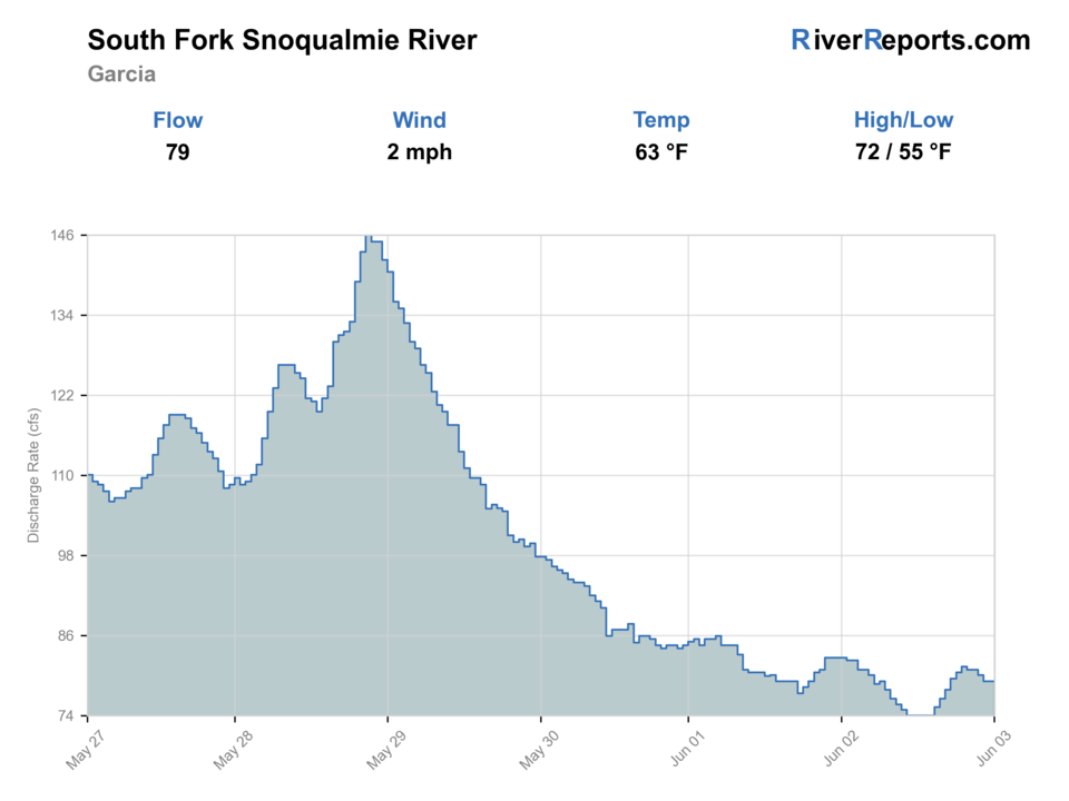
USGS data chart
Official USGS trend
Streamflow over the latest USGS reporting window.
Latest
77 cfs
Jun 3, 5 PM UTC
Weather
River weather report
Weather can change wading safety, road access, water temperature, hatches, and the best time of day to fish.
Live forecast loads as you reach this section
This keeps the report fast while still using the official National Weather Service forecast point.
Hatches and flies
Hatch chart and fly picks
Late winter to spring
Midges, stoneflies, and early caddis in cold clear windows
Stonefly nymph, zebra midge, olive bugger, caddis pupa
Summer
Caddis, pale mayflies, and terrestrials around shaded banks and gravel edges
Elk hair caddis, Adams, beetle, ant, perdigon
Early fall
Caddis and opportunistic baitfish windows around migrating salmon traffic
Sculpin streamer, caddis dry, egg imitation where legal and ethical
Late fall to winter
Sparse insect life and short cold-water feeding windows
Leech, stonefly nymph, egg pattern, small intruder-style swing fly
Trout and resident-fish flies
Pheasant tail, hare's ear, perdigon, caddis pupa, Adams
Good for low clear summer days and shoulder-season pocket water.
Light streamer support
Olive bugger, sculpin, sparse leech, minnow pattern
Useful after rain bumps or where wood and deeper slots hold better fish.
Seasonal salmonid support
Egg pattern, stonefly, soft hackle, sparse marabou
Carry them only when current regulations and fish handling support the plan.
Tactics
How to fish it
Fish the first safe pocket-water sequence thoroughly instead of racing to the next turnout.
Keep casts short and drifts clean because the best holding water here is usually compact.
If the gauge says the river is climbing, believe it before the color fully arrives.
Use the Garcia reach as a focused half-day plan, not as a place to force mileage.
Rigging
Rod, leader, and setup notes
A 4- or 5-weight with a dry-dropper or light nymph rig covers most summer and shoulder-season days here.
Carry one small streamer for darker pockets, wood, and post-rain water that still has shape.
Favor shorter leaders and controlled line management over long delicate presentations in the broken current.
Access
Access and planning notes
Garcia gauge
Primary upper-valley trendWade / float / trail
RiverReports / USGS gauge / trout
When to pick it
Start here when runoff and rain decide whether pocket water is safe.
Caution
The gauge does not confirm road pullouts, wood, visibility, or legal entry.
Olallie State Park South Fork access
Official upstream anchorWade / float / trail
State park / bank / short wade
When to pick it
Use it when flow and rules support a legal first look.
Caution
Park access still requires current signs, safe edges, and conservative wading.
Wagon Road Trail and Tinkham corridor
Trail and forest-road orientationWade / float / trail
Trail / pullout / bank
When to pick it
Pick it when you want public-corridor scouting before fishing one stretch.
Caution
Do not rush from pullout to pullout; canyon water changes fast.
Olallie State Park is the best official state-park access anchor for the upstream South Fork corridor.
Forest trailhead access helps with orientation, but it still does not make every roadside edge worth wading.
If you cannot see a clean exit before stepping in, keep walking or keep driving.
Regulations
Check before fishing
Check Washington fishing regulations and current emergency changes before fishing because this basin’s open windows and gear rules are not something to assume from memory.
Primary base
North Bend, Snoqualmie Pass, and the Tinkham corridor
Best day style
Forest-road pullouts, campground-adjacent scouting, and short wading sessions
Check first
Washington regulations, emergency changes, the 12143400 trend, Tinkham corridor conditions, and whether the river still has safe clear edges
Safety
Fast pocket water, slick cobble, steep banks, and weather changes that can turn a simple canyon stop into a hard exit
Gear
Helpful gear for this water
4- to 6-weight rod
A 5-weight covers the broadest mix of small streamers, dry-dropper rigs, and quick wading adjustments.
Wading staff
Worth carrying on slick cobble, woody edges, and fast knee-deep slots that look easier than they are.
Rain shell
A clear mountain morning can still turn into a cold wet exit by afternoon.
Thermometer
Useful on lower reaches and warm spells when responsible trout handling changes the plan.
Nearby water
Other water to research
Backup logic
Runoff or rain rise
Move to Middle Fork Snoqualmie or lower-elevation Cedar River at Renton.
Poor visibility or wood
Scout only, stay bank-first, or wait for the graph to settle.
Access uncertainty
Stay with signed park/trail access or choose a clearer public route.
Cold pushy water
Shorten the plan, skip crossings, or move to the lower valley.
Middle Fork Snoqualmie River
A broader public-land mountain-river alternative when you want more room to move.
Cedar River near Cedar Falls
A colder but much more access-limited upper-river option.
Cedar River at Renton
A lower-elevation fallback when canyon runoff or weather makes the upper South Fork a bad bet.
FAQ
Fast answers
Is South Fork Snoqualmie River fishable today?
South Fork Snoqualmie River looks very fishable right now. The live score is 96/100, based on current flow, weather, public alerts, and the report's planning context. Recheck the linked gauge and forecast before leaving because conditions can change quickly after rain, heat, access changes, or flow swings.
What flow is best for South Fork Snoqualmie River?
Use the Garcia gauge with trail and corridor access. Stable or gently falling water with clear edges is the best signal.
When should I skip South Fork Snoqualmie River?
Skip when runoff, rain, wood, poor visibility, or canyon current makes every pocket feel rushed before you rig.
Is South Fork Snoqualmie River safe to wade right now?
The fishability score is not a wading guarantee. Wade only where your chosen access has safe edges, clear footing, legal entry, and no forced crossings; high, rising, stained, or storm-affected water should be treated conservatively.
What makes the Garcia reach different from the lower South Fork near North Bend?
The Garcia reach is an upstream mountain-style corridor tied more directly to the 12143400 gauge, with colder pocket water and less town-style public access.
Where should I start on the Garcia reach?
Start with the Tinkham corridor and any clearly safe legal pull-ins, then commit to one short stretch instead of hopping all day.
When should I skip the Garcia reach?
Skip it when the river is rising, visibility is poor, or the current is strong enough that every step feels rushed.
Sources
Source set for this report
Reviewed 2026-06-02