
Washington / Pacific Northwest
Middle Fork Snoqualmie River
A Middle Fork Snoqualmie report for North Bend-area planning with live flow checks, Forest Service access guidance, and realistic mountain-river caution.
Image: Generated Washington planning image for Middle Fork Snoqualmie River / BlueStreamFly generated; not exact location / BlueStreamFlyFishability now: Middle Fork Snoqualmie River fishability today
GreatData confidence: High96/100
Fishable now because the live gauge is stable, weather is mild, and no public alert is active.
Flow observed
4:15 PM UTC
Weather observed
5:00 PM UTC
Score calculated
5:25 PM UTC
Why this rating
Flow
Weather
Public alerts
Next 6-12 hours
Hold
Stable live data supports staying with the plan, but recheck the gauge and forecast before leaving.
USGS flow
545 cfs
Current trend: flow stable, so weather, temperature, and access checks drive the next change.
More planning details: flies, flow bands, and live source checks
Fish it today
Start here
Base near North Bend, pick one or two Forest Road 56 or trailhead anchors, and fish those thoroughly instead of sprinting up valley.
Best flow clue
Use the Tanner gauge with road, trail, and closure context. Stable summer or slowly falling post-rain flow is the best signal.
Skip trigger
Skip when runoff or rain makes boulder water pushy, closures affect the chosen access, cold current hides bad footing, or storms are building in the valley.
Flow decision bands
Stable Tanner flow
Stable or slowly falling USGS 12141300 flow is the best pocket-water and boulder-seam signal.
Best public mountain window
Open road access, mild weather, clear seams, and safe banks make the route most useful.
Runoff or rain push
Cold high water, slick boulders, and poor crossings should keep the day bank-first or move it lower.
Closure or trail issue
Camping closures, road restrictions, or trailhead issues can weaken the day even when flow looks fishable.
USGS flow
545 cfs
Current trend: flow stable, so weather, temperature, and access checks drive the next change.
Live USGS flow
545 cfs / stable
Live NWS forecast
60F / Mostly Cloudy
Water temperature not verified
Heat guidance uses weather and river type unless an official water-temperature value is available.
No NWS alert flag
No active NWS alert was returned for this forecast point.
The Forest Service notes that the road parallels the river, which makes scouting easier but can tempt anglers into too many rushed stops.
The active camping-closure corridor is part of the current valley reality and worth checking before you assume your usual pull-off is available.
The river is wide enough that good footing matters more than one extra cast to the far seam.
Summer and early fall often give the cleanest all-around fly-fishing windows here.
Editorial review
How this report is maintained
This report starts with official regulation, access, flow, weather, and public-land sources, then adds practical planning guidance for fly anglers.
Byline
BlueStreamFly editorial desk
Reviewed by
BlueStreamFly source review
Maintained by
BlueStreamFly
Last material review
2026-06-02
Report confidence
High confidence
89/100
High confidence: RiverReports, USGS Tanner flow, Washington regulations and emergency rules, Forest Service access, closure and planning sources, weather coverage, image disclosure, and route-specific mountain trout guidance support the page. Confidence is moderated by road and camping closures, runoff timing, cold boulder water, recreation pressure, and fast weather changes.
Regulations
Washington sport-fishing and emergency-rule sources support the legal-check path.
Access
Forest Service Middle Fork access, closure, and planning sources strongly support the public-land access framework.
Flow and weather
RiverReports coverage is backed by USGS 12141300 near Tanner, and the National Weather Service point supports weather and safety decisions.
Fishing usefulness
The page now separates Tanner flow, public road and trailhead access, closure checks, runoff, boulder safety, pressure, and backup-water choices.
Fishability dashboard and source review
2026-06-02 / material content or source review
RiverReports, USGS 12141300 near Tanner, Washington sport-fishing and emergency-rule sources, Mount Baker-Snoqualmie National Forest Middle Fork access, closure and planning sources, National Weather Service data, and image-disclosure sources were checked before updating the current-fishability decision layer.
2026-06-02
Updated Middle Fork Snoqualmie River to the current fishability-page standard with Tanner trend bands, Forest Road 56 and trailhead access cards, runoff and closure skip cues, backup logic, stable fishability SEO, and confidence signals.
2026-05-28
Published a new Middle Fork Snoqualmie River report with Forest Service access guidance, flow support, and closure-aware trip planning.
Angler planning edge
Local details that change the plan
Best for
Seattle-area mountain trout days, public-land wade planning, summer and early-fall pocket water
Wade or float
Wade and walk from Forest Service road and trailhead access; treat this as a public mountain trout route, not a float page.
Best flows
Use the Tanner gauge with road, trail, and closure context. Stable summer or slowly falling post-rain flow is the best signal.
When to skip
Skip when runoff or rain makes boulder water pushy, closures affect the chosen access, cold current hides bad footing, or storms are building in the valley.
Local plan
Base near North Bend, pick one or two Forest Road 56 or trailhead anchors, and fish those thoroughly instead of sprinting up valley.
Pressure
Recreation pressure is real near obvious pullouts, but safe flow and access status matter more than finding secrecy.
Access nuance
Public access is the strength here; use official road, trailhead, and closure sources to simplify the day.
Backup water
Drop to Cedar River at Renton when mountain water is pushy, or compare Cedar Falls only when its public-edge access is clearly legal.
About the river
Setting, character, and why it fishes the way it does.
The Middle Fork Snoqualmie is one of the rare rivers close to Seattle that feels both accessible and genuinely mountainous. That combination is why it stays popular, and also why safety and discipline matter more than many anglers admit.
The Forest Service access pages are especially useful here because they clarify how the road, trailheads, and river corridor fit together. That is better information than informal pin-dropping or vague social posts.
For BlueStreamFly readers, the right mindset is to fish the Middle Fork like a public mountain river with lots of options, not like a crowdsourced scavenger hunt.
Target species
Cutthroat trout
A core target in the lower, clearer windows that reward clean drifts and careful wading.
Resident rainbow and trout mix
Part of the general mountain-river appeal in summer and early fall.
Whitefish
A cold-water bonus that can keep a day interesting when trout stay deep.
Seasonal salmon context
Worth respecting in the watershed even when the fly plan focuses elsewhere.
Reading the water
Stable summer flow
Best for pocket-water fishing, trail-based access, and realistic day-length planning.
Cold pushy flow
Reduce the day to the easiest banks and most obvious safe water or skip entirely.
Post-rain green water
Can fish well if you stay on obvious seams and do not push the crossing game.
Low clear water
Great for technical drifts, but fish will punish sloppy approach angles.
Best seasons
Late spring
Useful once runoff settles enough to reveal structure instead of just volume.
Summer
Often the best blend of access, clarity, and all-day fishability.
Early fall
Strong for cool mornings, clean water, and more deliberate small-fly fishing.
Winter
A selective option only on stable days and only for anglers who respect cold fast water.
Preferred flow source
Middle Fork Snoqualmie River near Tanner
RiverReports is the preferred chart source when coverage exists. When a matching USGS gauge exists, keep it open as the official backstop for station data and current hydrograph context.
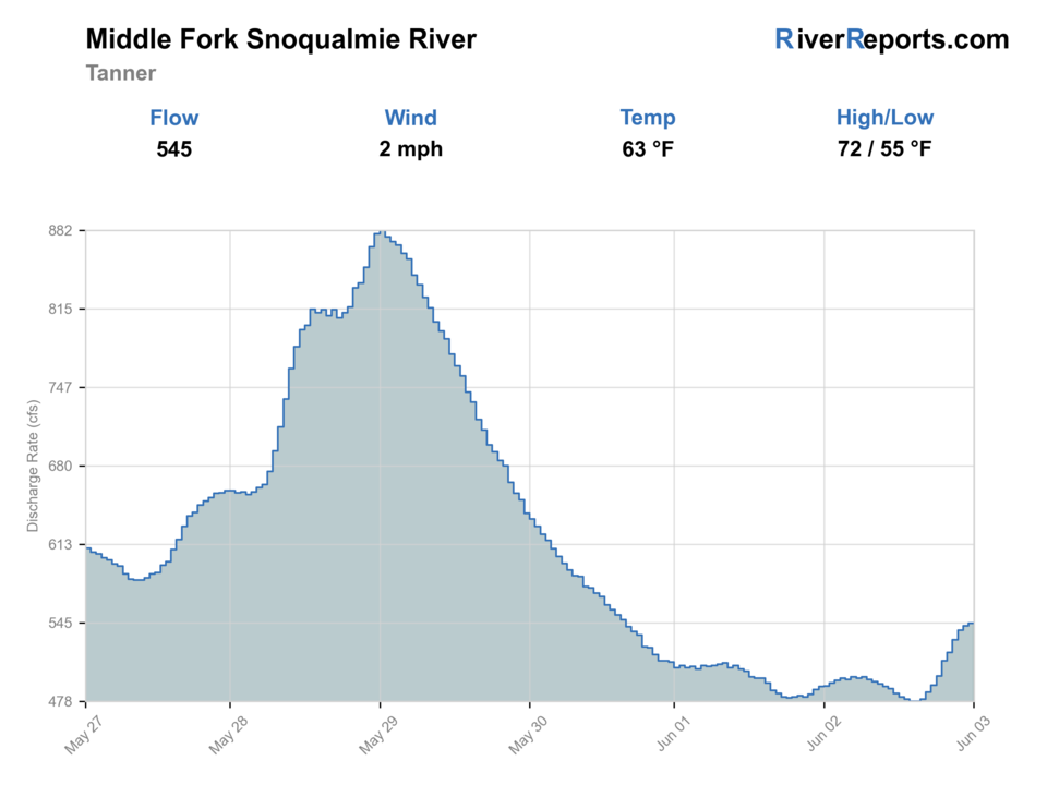
USGS data chart
Official USGS trend
Streamflow over the latest USGS reporting window.
Latest
545 cfs
Jun 3, 4 PM UTC
Weather
River weather report
Weather can change wading safety, road access, water temperature, hatches, and the best time of day to fish.
Live forecast loads as you reach this section
This keeps the report fast while still using the official National Weather Service forecast point.
Hatches and flies
Hatch chart and fly picks
Late winter to spring
Midges, stoneflies, and early caddis in cold, clear windows
Stonefly nymph, zebra midge, olive bugger, caddis pupa
Summer
Caddis, pale mayflies, and terrestrials around shaded banks and gravel edges
Elk hair caddis, Adams, beetle, ant, perdigon
Early fall
Caddis and opportunistic baitfish windows around migrating salmon
Sculpin streamer, caddis dry, egg imitation where legal and ethical
Late fall to winter
Sparse insect life and short steelhead-friendly windows
Leech, stonefly nymph, egg pattern, intruder-style swing fly
Trout and resident fish flies
Pheasant tail, hare's ear, perdigon, caddis pupa, Adams
Good for the low, clear summer and shoulder-season days that reward careful presentations.
Steelhead and salmon support flies
Sparse intruder, leech, stonefly, egg pattern
Carry them whenever seasonal runs or colored water justify a bigger offering.
Small streamers
Olive bugger, sculpin, minnow pattern
Useful along cut banks, deeper slots, and post-rain push when fish stop rising.
Tactics
How to fish it
Pick a trailhead or road-corridor anchor and fish that water deeply before driving farther up valley.
Work pocket water, boulder seams, and current transitions with short controlled presentations.
If the river is high, avoid the urge to wade just because access was easy.
Use the Middle Fork for a mountain-river reset when lower urban rivers feel warm or crowded.
Rigging
Rod, leader, and setup notes
A 4- or 5-weight with a dry-dropper or light nymph rig covers most prime Middle Fork days.
Carry a small streamer for deeper slots after rain bumps or on cold mornings.
Short casts and efficient line control outfish hero mends on this kind of bouldery current.
Access
Access and planning notes
Tanner gauge
Primary mountain-river trendWade / float / trail
RiverReports / USGS gauge / trout
When to pick it
Start here when runoff, rain, and boulder-water safety decide the day.
Caution
The gauge does not replace road, trailhead, closure, or weather checks.
Forest Road 56 corridor
Main public access spineWade / float / trail
Forest road / bank / wade
When to pick it
Use it when road status and flow support a simple two-stop plan.
Caution
Easy roadside access can hide cold, fast water and difficult exits.
Middle Fork Trailhead and campground/day-use zone
Trail and public-land anchorWade / float / trail
Trailhead / bank / wade
When to pick it
Pick it when closures and recreation pressure still leave a practical access plan.
Caution
Check current restrictions before assuming your usual stop is open.
Use Forest Service road and trailhead guidance instead of informal map pins.
Camping and day-use restrictions can change how crowded or practical a stop feels.
The easiest-to-reach water is not always the safest water to wade.
Regulations
Check before fishing
Check Washington sport fishing rules first, then confirm any closure or access notices on the Forest Service side before you drive up valley.
Primary base
North Bend and the Middle Fork road corridor
Best day style
Forest road, trailhead, and riverside public-land access with a lot of room to explore and plenty of ways to overdo it
Check first
Washington rules, 12141300 flow, road and trail access, closure notices, and the weather trend in the valley
Safety
Cold fast current, slick boulders, woody edges, and the false confidence that comes from easy road access
Gear
Helpful gear for this water
4- to 6-weight rod
A 5-weight covers the widest mix of summer trout, cutthroat, and light streamer work.
Wading staff
A worthwhile safety tool on boulder gardens, woody edges, and sudden ledge drops.
Rain shell
Mountain and Puget weather can turn a clear morning into a wet canyon by lunch.
Thermometer
Helpful on urban or lowland reaches where warm water should change the plan before the first cast.
Nearby water
Other water to research
Backup logic
Runoff or high water
Drop to Cedar River at Renton or another lower-elevation option.
Road or closure issue
Use a different confirmed trailhead or pick the lower Cedar.
Cold slick boulder water
Stay bank-first, shorten the session, or wait for a lower trend.
Warm lower rivers
Use the Middle Fork early and keep trout handling quick.
Cedar River at Renton
A lower-elevation Seattle-area option when mountain runoff looks too strong.
Cedar River near Cedar Falls
A more restricted upper-river option closer to the watershed edge.
Skykomish River
A bigger-flow changeup if you want a broader western Washington river day.
FAQ
Fast answers
Is Middle Fork Snoqualmie River fishable today?
Middle Fork Snoqualmie River looks very fishable right now. The live score is 96/100, based on current flow, weather, public alerts, and the report's planning context. Recheck the linked gauge and forecast before leaving because conditions can change quickly after rain, heat, access changes, or flow swings.
What flow is best for Middle Fork Snoqualmie River?
Use the Tanner gauge with road, trail, and closure context. Stable summer or slowly falling post-rain flow is the best signal.
When should I skip Middle Fork Snoqualmie River?
Skip when runoff or rain makes boulder water pushy, closures affect the chosen access, cold current hides bad footing, or storms are building in the valley.
Is Middle Fork Snoqualmie River safe to wade right now?
The fishability score is not a wading guarantee. Wade only where your chosen access has safe edges, clear footing, legal entry, and no forced crossings; high, rising, stained, or storm-affected water should be treated conservatively.
Why fish the Middle Fork Snoqualmie instead of a more famous Washington river?
Because it gives Seattle-area anglers real public mountain-river access without needing a long coastal drive, as long as you respect current and closure limits.
Is the Middle Fork easy to wade?
Not automatically. Access is easy, but the river still has slick boulders, pushy current, and cold water that can punish lazy decisions.
What should I check before heading up the valley?
Check RiverReports, USGS 12141300, Forest Service access and closure pages, and the weather trend before you commit.
Sources
Source set for this report
Reviewed 2026-06-02