
Washington / Pacific Northwest
Cedar River
A lower Cedar report for Renton-area planning with live flow checks, public-trail orientation, urban-river caution, and realistic salmon-season pressure notes.
Image: Generated Washington planning image for Cedar River at Renton / BlueStreamFly generated; not exact location / BlueStreamFlyFishability now: Cedar River fishability today
GreatData confidence: High96/100
Fishable now because Renton gauge is stable, weather is mild, and no public alert is active.
Flow observed
3:15 PM UTC
Weather observed
4:00 PM UTC
Score calculated
4:22 PM UTC
Why this rating
Flow
Water temperature
Public alerts
Next 6-12 hours
Hold
Stable live data supports staying with the plan, but recheck the gauge and forecast before leaving.
USGS flow
327 cfs
Current trend: flow stable, so weather, temperature, and access checks drive the next change.
More planning details: flies, flow bands, and live source checks
Fish it today
Start here
Start at Cedar River Park or the Cedar River Trail Park area, read the Renton gauge and current rules, then fish one compact public stretch well.
Best flow clue
Use the Renton gauge with Seattle instream-flow context. Stable or slowly falling water with workable clarity is the best signal.
Skip trigger
Skip when rain muddies the lower corridor, warm weather stresses trout, salmon activity makes the water crowded or ethically messy, or public access is unclear.
Flow decision bands
Stable Renton flow
Stable or slowly falling USGS 12119000 flow with readable clarity is the best lower-Cedar signal.
Best public-corridor window
Mild weather, public park access, safe banks, and no salmon-season crowding make a short session most useful.
Rain bump or urban stain
Fresh rain, muddy edges, or a rising graph should move the plan to scouting or another water.
Warm or salmon-sensitive
Warm trout conditions or heavy salmon activity can override a fishable-looking flow.
USGS flow
327 cfs
Current trend: flow stable, so weather, temperature, and access checks drive the next change.
Live USGS flow
331 cfs / stable
Live NWS forecast
63F / Mostly Cloudy
Live water temperature
57F from USGS
No NWS alert flag
No active NWS alert was returned for this forecast point.
Seattle's instream-flow management is part of the lower-Cedar story, so level changes are not just rain-driven.
Public access improves near Renton parks and trails, but the river still deserves conservative footing and fish handling.
Seasonal salmon activity can change both crowding and the ethical tone of the day fast.
Warm weather should push you toward shorter sessions and stronger release discipline.
Editorial review
How this report is maintained
This report starts with official regulation, access, flow, weather, and public-land sources, then adds practical planning guidance for fly anglers.
Byline
BlueStreamFly editorial desk
Reviewed by
BlueStreamFly source review
Maintained by
BlueStreamFly
Last material review
2026-06-02
Report confidence
High confidence
88/100
High confidence: RiverReports, USGS Renton flow, Washington regulation and emergency-rule sources, Seattle Cedar flow-management sources, Renton public access, weather coverage, image disclosure, and route-specific lower-Cedar guidance support the page. Confidence is moderated by salmon-season pressure, urban access limits, water temperature, and lower-river clarity after rain.
Regulations
Washington sport-fishing and emergency-rule sources support the legal-check path, with salmon-season context requiring day-of care.
Access
Renton parks and trail sources strongly support the public-access framework for a lower-Cedar plan.
Flow and weather
RiverReports coverage is backed by USGS 12119000 at Renton, with Seattle instream-flow sources and National Weather Service data supporting flow, rain, and heat decisions.
Fishing usefulness
The page now separates Renton flow, park and trail access, rain clarity, salmon-sensitive crowding, trout heat risk, and backup-water choices.
Fishability dashboard and source review
2026-06-02 / material content or source review
RiverReports, USGS 12119000 at Renton, Washington sport-fishing and emergency-rule sources, Seattle Cedar River instream-flow sources, Renton park and trail access sources, WDFW American shad context, National Weather Service data, and image-disclosure sources were checked before updating the current-fishability decision layer.
2026-06-02
Updated Cedar River at Renton to the current fishability-page standard with Renton trend bands, public park and trail access cards, salmon-season skip cues, backup logic, stable fishability SEO, and confidence signals.
2026-05-28
Published a new Cedar River at Renton report with lower-river access anchors, flow context, and urban-corridor handling notes.
Angler planning edge
Local details that change the plan
Best for
Seattle-area half days, public lower-Cedar scouting, salmon-aware trout and cutthroat planning
Wade or float
Wade and walk from obvious public parks and trails; this is a lower urban river plan, not a float or random-bank access page.
Best flows
Use the Renton gauge with Seattle instream-flow context. Stable or slowly falling water with workable clarity is the best signal.
When to skip
Skip when rain muddies the lower corridor, warm weather stresses trout, salmon activity makes the water crowded or ethically messy, or public access is unclear.
Local plan
Start at Cedar River Park or the Cedar River Trail Park area, read the Renton gauge and current rules, then fish one compact public stretch well.
Pressure
Visibility and recreation traffic matter more than solitude; weekday and early starts are cleaner.
Access nuance
Lower Cedar public access is stronger than the upper watershed, but trails, levees, fish-sensitive zones, and posted limits still define the day.
Backup water
Move to Middle Fork Snoqualmie for cooler mountain water, Cedar Falls only if the legal public edge is clear, or another Seattle-area river when the lower Cedar is warm or crowded.
About the river
Setting, character, and why it fishes the way it does.
Below the watershed-control infrastructure, the Cedar becomes a very different river. It is still shaped by water management, but now it is also a public corridor with parks, trails, flood-control work, and urban visibility.
That combination makes it useful and easy to misuse. Plenty of anglers arrive expecting a wild mountain river and leave frustrated because they never adjusted to the lower-river pace, pressure, and fish-handling reality.
For BlueStreamFly readers, the right approach is to fish the lower Cedar on purpose: choose public access, read the flow, keep your expectations seasonal, and avoid turning salmon-sensitive water into a numbers game.
Target species
Resident trout and cutthroat context
Most realistic when flows are moderate and water temperatures stay reasonable.
Salmon seasonal presence
A major part of the river's rhythm and one reason crowding and handling standards matter.
Steelhead context
Part of the larger watershed story more than a casual every-trip expectation.
American shad context
An official WDFW reminder that lower-Cedar species mixes can surprise anglers near Renton.
Reading the water
Stable moderate flow
Best for reading seams, fishing clean drifts, and moving safely between public access points.
Rain bump
Can improve fish movement but quickly reduce clarity and tighten wading room along leveed banks.
Warm low flow
Shorten the session, favor early or late light, and release fish quickly.
Heavy seasonal salmon traffic
Treat fish handling and angler spacing as part of the condition report, not as an afterthought.
Best seasons
Spring
Good when the river is dropping into shape and the lower corridor is not blown out by rain.
Summer
Fishable early and late if temperatures stay responsible and you accept the urban rhythm.
Fall
Often the most interesting season because salmon context changes the whole river.
Winter
A selective short-session option on stable days, not a default all-day plan.
Preferred flow source
Cedar River at Renton
RiverReports is the preferred chart source when coverage exists. When a matching USGS gauge exists, keep it open as the official backstop for station data and current hydrograph context.
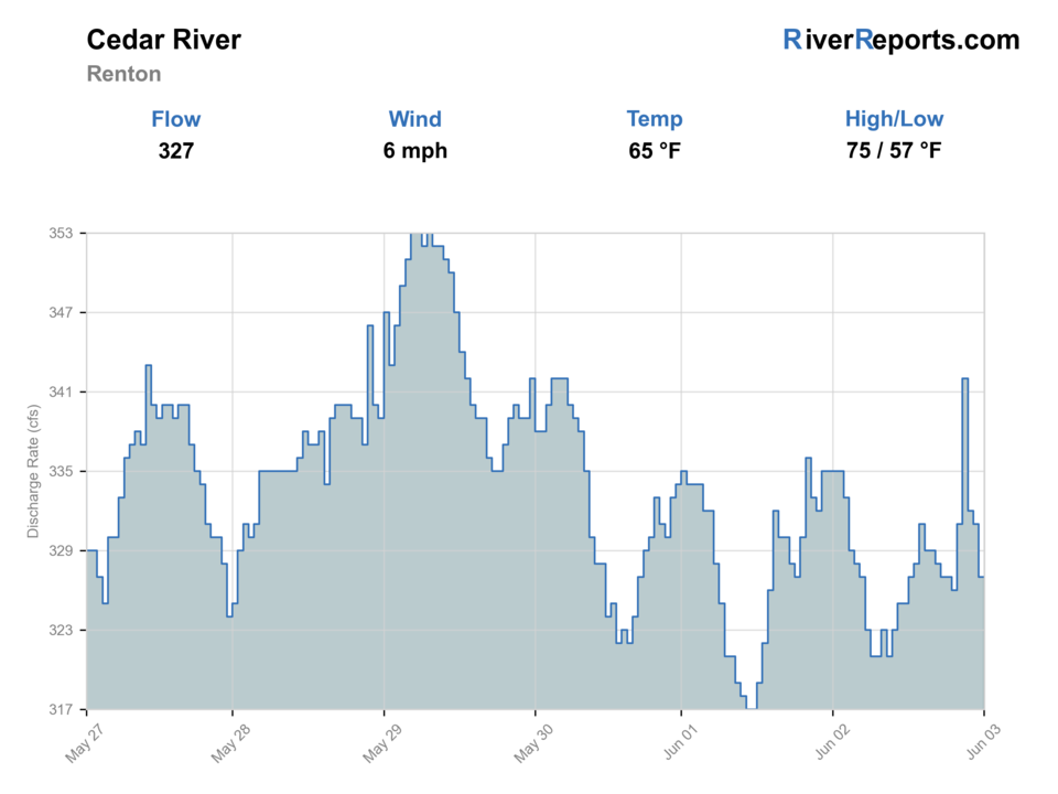
USGS data chart
Official USGS trend
Streamflow over the latest USGS reporting window.
Latest
327 cfs
Jun 3, 4 PM UTC
Weather
River weather report
Weather can change wading safety, road access, water temperature, hatches, and the best time of day to fish.
Live forecast loads as you reach this section
This keeps the report fast while still using the official National Weather Service forecast point.
Hatches and flies
Hatch chart and fly picks
Late winter to spring
Midges, stoneflies, and early caddis in cold, clear windows
Stonefly nymph, zebra midge, olive bugger, caddis pupa
Summer
Caddis, pale mayflies, and terrestrials around shaded banks and gravel edges
Elk hair caddis, Adams, beetle, ant, perdigon
Early fall
Caddis and opportunistic baitfish windows around migrating salmon
Sculpin streamer, caddis dry, egg imitation where legal and ethical
Late fall to winter
Sparse insect life and short steelhead-friendly windows
Leech, stonefly nymph, egg pattern, intruder-style swing fly
Trout and resident fish flies
Pheasant tail, hare's ear, perdigon, caddis pupa, Adams
Good for the low, clear summer and shoulder-season days that reward careful presentations.
Steelhead and salmon support flies
Sparse intruder, leech, stonefly, egg pattern
Carry them whenever seasonal runs or colored water justify a bigger offering.
Small streamers
Olive bugger, sculpin, minnow pattern
Useful along cut banks, deeper slots, and post-rain push when fish stop rising.
Tactics
How to fish it
Fish from clear public anchors like parks and trail sections instead of improvising private or unsafe bank entries.
Cover deeper seams and current breaks first because the lower Cedar can look simpler than it actually fishes.
When salmon are present, keep accidental encounters short and clean and refocus on legal target fish or move.
Use this reach for an efficient half-day when conditions are right, not for a forced marathon on warm or crowded water.
Rigging
Rod, leader, and setup notes
A 5-weight with nymphs, caddis dries, and a small streamer covers most realistic lower-Cedar scenarios.
Carry slightly heavier tippet than you would on a tiny creek because current and wood matter.
If water is colored after rain, use a darker small streamer or stonefly-style nymph to stay visible without getting gaudy.
Access
Access and planning notes
Renton gauge
Primary lower-Cedar trendWade / float / trail
RiverReports / USGS gauge / urban trout
When to pick it
Start here when flow direction and rain clarity decide whether the lower corridor is worth fishing.
Caution
The gauge does not confirm legal access, water temperature, fish handling, or crowd conditions at a park.
Cedar River Park
Public starting pointWade / float / trail
Park / bank / short wade
When to pick it
Use it when you want an obvious public anchor before choosing flies.
Caution
Urban banks, trail traffic, salmon viewers, and posted signs still matter.
Cedar River Trail Park and Renton trail corridor
Scout before committingWade / float / trail
Trail / bank / wade
When to pick it
Pick it when you want to inspect clarity and bank safety from public access before stepping in.
Caution
Do not turn trail visibility into permission for every bank or side channel.
Renton public parks and trails are the cleanest access anchors on this reach.
The lower 1.25 miles near downtown Renton is heavily modified and should be treated as an urban safety corridor first.
Stay off soft or undercut banks, especially after rain and during high salmon traffic.
Regulations
Check before fishing
Check Washington sport fishing rules and emergency changes, then match your trip to the species and seasonal protections in play that day.
Primary base
Renton, Maple Valley, and the lower Cedar corridor
Best day style
Trail- and park-based lower-river access with urban pressure, levee sections, and fish-sensitive seasonal context
Check first
Washington rules, 12119000 flow, recent rain, public-park access, and whether salmon activity changes where or how you should fish
Safety
Urban current traps, levee-lined banks, slippery trail edges, and crowded seasonal salmon-viewing zones
Gear
Helpful gear for this water
4- to 6-weight rod
A 5-weight covers the widest mix of summer trout, cutthroat, and light streamer work.
Wading staff
A worthwhile safety tool on boulder gardens, woody edges, and sudden ledge drops.
Rain shell
Mountain and Puget weather can turn a clear morning into a wet canyon by lunch.
Thermometer
Helpful on urban or lowland reaches where warm water should change the plan before the first cast.
Nearby water
Other water to research
Backup logic
High or muddy water
Compare Middle Fork Snoqualmie or wait for the lower Cedar to settle.
Warm trout conditions
Fish early, keep releases quick, or choose a colder mountain option.
Salmon crowding or handling concern
Move away from crowded lower-river zones or pick another route.
Access uncertainty
Stay with signed public parks and trails instead of improvising banks.
Middle Fork Snoqualmie River
A better choice when you want a more mountainous public-land feel.
Cedar River near Cedar Falls
A colder but much more restricted upper-Cedar option.
Green River
Another greater-Seattle fallback when the lower Cedar feels too warm or crowded.
FAQ
Fast answers
Is Cedar River fishable today?
Cedar River looks very fishable right now. The live score is 96/100, based on current flow, weather, public alerts, and the report's planning context. Recheck the linked gauge and forecast before leaving because conditions can change quickly after rain, heat, access changes, or flow swings.
What flow is best for Cedar River?
Use the Renton gauge with Seattle instream-flow context. Stable or slowly falling water with workable clarity is the best signal.
When should I skip Cedar River?
Skip when rain muddies the lower corridor, warm weather stresses trout, salmon activity makes the water crowded or ethically messy, or public access is unclear.
Is Cedar River safe to wade right now?
The fishability score is not a wading guarantee. Wade only where your chosen access has safe edges, clear footing, legal entry, and no forced crossings; high, rising, stained, or storm-affected water should be treated conservatively.
Where should I start on the Cedar River near Renton?
Start with public parks and trailheads like Cedar River Park or Cedar River Trail Park so you can scout the river without guessing on access.
Is the Renton reach better than the upper Cedar?
It is better for public access, but not automatically better fishing. It fishes more like an urban corridor and less like a secluded mountain river.
What matters most before a lower Cedar trip?
Check RiverReports, USGS 12119000, public access, rain-driven clarity changes, and whether salmon activity should change your plan.
Sources
Source set for this report
Reviewed 2026-06-02