
North Carolina / Southeast
Oconaluftee River
An Oconaluftee report for anglers checking live flows, Great Smoky Mountains National Park rules, Cherokee Enterprise Waters permits, hatches, and access.
Image: Generated regional planning image for Oconaluftee River / BlueStreamFly generated; not exact location / BlueStreamFlyFishability now: Oconaluftee River fishability today
GreatData confidence: High96/100
Fishable now because Birdtown gauge is falling, weather is usable, and no public alert is active.
Flow observed
5:00 PM UTC
Weather observed
5:00 PM UTC
Score calculated
5:24 PM UTC
Why this rating
Flow
Water temperature
Public alerts
Next 6-12 hours
Improving / hold
A falling gauge and usable weather should keep the next 6-12 hours in play unless tributaries stain or heat builds.
USGS flow
347 cfs
Current trend: flow falling, rating likely holding strong unless weather or clarity changes.
More planning details: flies, flow bands, and live source checks
Fish it today
Start here
Base in Cherokee or near the Oconaluftee entrance; check gauge, jurisdiction, and weather before picking a reach.
Best flow clue
Stable clear flows that keep pocket water connected without creating unsafe crossings or blown-out banks.
Skip trigger
Skip during storm rises, unclear permit status, crowded roadside conditions, or warm trout-stress windows.
Flow decision bands
Stable Birdtown flow
Stable or slowly falling Birdtown flow with clear water is the best signal for park, Cherokee, or lower-river trout plans.
Best jurisdiction-clear window
Mild weather, confirmed permit or rule set, safe pocket water, and manageable roadside pressure make the river most useful.
Storm rise or fast clear water
Thunderstorm bumps, pushy current, or unsafe crossings should move the plan bank-first or to another river.
Permit, crowd, or warm-water issue
Unclear jurisdiction, missing Cherokee permit, visitor traffic, or hot trout-handling conditions can override a fishable flow.
USGS flow
347 cfs
Current trend: flow falling, rating likely holding strong unless weather or clarity changes.
Live USGS flow
347 cfs / falling about 19%
Live NWS forecast
75F / Sunny
Live water temperature
62F from USGS
No NWS alert flag
No active NWS alert was returned for this forecast point.
RiverReports is the quick chart, backed by USGS 03512000 Oconaluftee River at Birdtown, North Carolina.
Great Smoky Mountains National Park has its own fishing rules and bait restrictions for park waters.
Cherokee Enterprise Waters require the proper tribal permit and have their own regulations.
Storms can raise the river fast, and clear water demands careful wading and clean presentations.
Editorial review
How this report is maintained
This report starts with official regulation, access, flow, weather, and public-land sources, then adds practical planning guidance for fly anglers.
Byline
BlueStreamFly editorial desk
Reviewed by
BlueStreamFly source review
Maintained by
BlueStreamFly
Last material review
2026-06-02
Report confidence
High confidence
90/100
High confidence: RiverReports, USGS Birdtown flow, NCWRC regulation resources, Great Smoky Mountains National Park fishing and Oconaluftee sources, Fish Cherokee rules, weather coverage, image disclosure, and route-specific jurisdiction guidance support the page. Confidence is moderated by permit status, close jurisdiction changes, roadside pressure, storm response, and warm-season trout handling.
Regulations
NCWRC, Great Smoky Mountains National Park, and Fish Cherokee sources support the rule-check path across the route's jurisdictions.
Access
Great Smoky Mountains National Park Oconaluftee information, Fish Cherokee context, and NCWRC resources support the public and permit-based access framework.
Flow and weather
RiverReports coverage is backed by USGS 03512000 at Birdtown, and the National Weather Service point supports storm and heat decisions.
Fishing usefulness
The page now separates Birdtown flow, park rules, Cherokee permits, roadside pressure, storm rises, warm-water restraint, and backup-water choices.
Fishability dashboard and source review
2026-06-02 / material content or source review
RiverReports, USGS 03512000 at Birdtown, NCWRC fishing regulations and trout resources, Great Smoky Mountains National Park fishing and Oconaluftee area sources, Fish Cherokee rules and regulations, National Weather Service point data, and image-disclosure sources were checked before updating the current-fishability decision layer.
2026-06-02
Updated Oconaluftee River to the current fishability-page standard with Birdtown trend bands, park and Cherokee jurisdiction cards, permit and storm backup cues, stable fishability SEO, and confidence signals.
2026-05-26
Published a new Oconaluftee River report with jurisdiction-specific rule reminders, Smokies access planning, hatches, tactics, and safety guidance.
Angler planning edge
Local details that change the plan
Best for
Smokies trout planning, Cherokee permit checks, Clear-water dry-dropper days
Wade or float
Wade planning is typical, but only in stable water and only after confirming the correct rule set for the reach.
Best flows
Stable clear flows that keep pocket water connected without creating unsafe crossings or blown-out banks.
When to skip
Skip during storm rises, unclear permit status, crowded roadside conditions, or warm trout-stress windows.
Local plan
Base in Cherokee or near the Oconaluftee entrance; check gauge, jurisdiction, and weather before picking a reach.
Pressure
Roadside and visitor-center areas can be busy. Fish early, move carefully, and respect wildlife-viewing traffic.
Access nuance
Park water, Cherokee Enterprise Waters, and state-managed water can sit close together. Rules change with the reach.
Backup water
Nantahala, Davidson, and French Broad pages give alternate trout or warmwater plans when the Oconaluftee is not right.
About the river
Setting, character, and why it fishes the way it does.
The Oconaluftee rises in the Great Smoky Mountains and flows through one of the most culturally important river valleys in North Carolina before joining the Tuckasegee system.
For anglers, that means the river is not just a flow line on a map. Park rules, Cherokee Enterprise Waters permits, visitor traffic, elk viewing areas, and road access can all shape the day.
When the water is right, the river offers freestone runs, pocket water, clear glides, and stocked or wild trout context depending on reach and management area.
Target species
Rainbow trout
Common in park and Cherokee-area trout planning; check the applicable rules before harvest assumptions.
Brown trout
A practical target in larger pools, low light, and streamer water.
Brook trout
Native-trout context is important in the Smokies; handle fish carefully and respect park conservation rules.
Reading the water
Stable clear flow
Best for dry-dropper fishing, small nymphs, and careful pocket-water presentations.
Rising storm water
Leave the river. Smoky Mountains streams can rise quickly.
Low and bright
Use longer leaders, lighter tippet, and shade-first approaches.
Light stain
Small streamers or larger nymphs can work along protected banks.
Best seasons
Spring
Good hatches and active trout when storms do not push flows too high.
Summer
Fish early and check temperature, crowds, and storm timing.
Fall
Often a strong mix of cooler water, lower flows, and scenic pressure.
Winter
Technical but fishable when weather, access, and rules line up.
Preferred flow source
Oconaluftee River at Birdtown
RiverReports is the preferred chart source when coverage exists. When a matching USGS gauge exists, keep it open as the official backstop for station data and current hydrograph context.
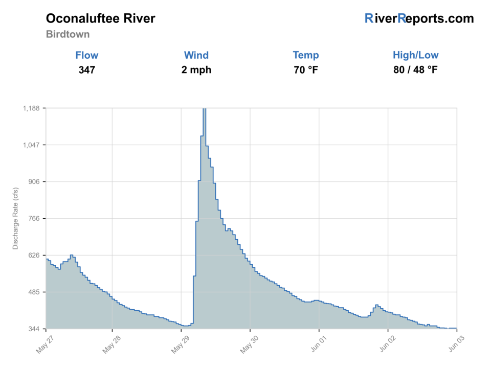
USGS data chart
Official USGS trend
Streamflow over the latest USGS reporting window.
Latest
347 cfs
Jun 3, 5 PM UTC
Weather
River weather report
Weather can change wading safety, road access, water temperature, hatches, and the best time of day to fish.
Live forecast loads as you reach this section
This keeps the report fast while still using the official National Weather Service forecast point.
Hatches and flies
Hatch chart and fly picks
March-April
Quill-style mayflies, midges, early caddis
Parachute Adams, pheasant tail, zebra midge, caddis pupa
April-June
Caddis, yellow sallies, sulphur-style mayflies
Elk hair caddis, yellow stimulator, hare's ear, soft hackle
June-August
Terrestrials, caddis, small mayflies
Ant, beetle, foam dry-dropper, X-caddis
September-November
BWOs, midges, caddis
BWO emerger, zebra midge, olive bugger
Smokies dries
Parachute Adams, elk hair caddis, yellow stimulator, ant
Broken water and shade let fish look up.
Nymphs
Pheasant tail, hare's ear, caddis pupa, perdigon
Pocket water is clear but trout are not rising.
Small streamers
Olive bugger, black bugger, small sculpin
Low light, light stain, or deeper banks give trout cover.
Tactics
How to fish it
Confirm the rule set first: park water, Cherokee Enterprise Waters, or state-managed water.
Fish short drifts through pocket water before stepping into the run.
Use lighter tippet and clean casting in clear low water.
Give wildlife, visitors, and roadside pullouts space; this is a busy public corridor.
Rigging
Rod, leader, and setup notes
A 4- or 5-weight rod covers most Oconaluftee trout fishing.
Carry 4X through 6X for dries and nymphs, and stronger tippet for streamers or stocked-water conditions.
Dry-dropper rigs are efficient in pocket water; small indicators help in deeper runs.
Use a thermometer, wading staff, and rain shell for changing mountain conditions.
Access
Access and planning notes
Oconaluftee at Birdtown gauge
Primary flow trendWade / float / trail
RiverReports / USGS gauge / trout
When to pick it
Start here when flow, clarity, and crossing safety decide whether to fish.
Caution
The gauge does not tell you which rule set applies to the bank in front of you.
Great Smoky Mountains National Park water
Park-rule trout planWade / float / trail
National Park Service / roadside / wade
When to pick it
Use it when your reach is inside park water and current park fishing rules match the plan.
Caution
Park rules, wildlife traffic, road access, and bait restrictions need current confirmation.
Cherokee Enterprise Waters
Permit-based trout planWade / float / trail
Tribal permit / roadside / wade
When to pick it
Pick this only after confirming Fish Cherokee rules, permits, and reach status.
Caution
Cherokee rules are not the same as park or state rules; do not blend jurisdictions.
The same river crosses different management areas. Do not fish until you know which rules apply.
Cherokee Enterprise Waters require the proper permit and compliance with tribal regulations.
Park waters have bait, hook, and possession rules that differ from general assumptions.
Regulations
Check before fishing
Confirm NPS fishing rules, Cherokee Enterprise Waters permit rules, and NCWRC regulations as applicable to the reach you plan to fish.
Primary base
Cherokee, Oconaluftee, Bryson City, or Great Smoky Mountains National Park
Best day style
Roadside, park, and Cherokee Enterprise Waters planning with jurisdiction-specific rules
Check first
RiverReports, USGS 03512000, NPS fishing rules, Fish Cherokee rules, NCWRC regulations, and NWS weather
Safety
Fast storm rises, slick cobble, roadside traffic, wildlife viewing crowds, jurisdiction-specific rules, and cold mountain water
Gear
Helpful gear for this water
4- or 5-weight rod
A good fit for Smokies dries, nymphs, and small streamers.
Long leaders
Helpful in clear low water and pressured roadside pools.
Wading staff
Useful on rounded cobble and fast pocket water.
Permit check
Make the correct license or tribal permit part of the gear list before leaving.
Nearby water
Other water to research
Backup logic
Storm rise
Compare Nantahala, Davidson, or French Broad depending on whether trout water or a warmwater plan is safer.
Permit or jurisdiction uncertainty
Confirm the exact rule set before fishing or pick a simpler NCWRC-backed route.
Crowded roadside water
Start earlier, choose a different legal reach, or move to another Smokies-area plan.
Warm trout window
Fish cooler hours only and handle trout quickly, or stop trout fishing.
Nantahala River
A colder mountain river with separate flow and access planning.
Davidson River
A highly pressured but productive Pisgah trout option.
French Broad River
A larger Asheville-area warmwater option when mountain trout water is high or crowded.
FAQ
Fast answers
Is Oconaluftee River fishable today?
Oconaluftee River looks very fishable right now. The live score is 96/100, based on current flow, weather, public alerts, and the report's planning context. Recheck the linked gauge and forecast before leaving because conditions can change quickly after rain, heat, access changes, or flow swings.
What flow is best for Oconaluftee River?
Stable clear flows that keep pocket water connected without creating unsafe crossings or blown-out banks.
When should I skip Oconaluftee River?
Skip during storm rises, unclear permit status, crowded roadside conditions, or warm trout-stress windows.
Is Oconaluftee River safe to wade right now?
The fishability score is not a wading guarantee. Wade only where your chosen access has safe edges, clear footing, legal entry, and no forced crossings; high, rising, stained, or storm-affected water should be treated conservatively.
What gauge should I use for the Oconaluftee River?
Use RiverReports for the quick chart and USGS 03512000 at Birdtown for the official gauge reference.
Do I need a Cherokee fishing permit?
If you fish Cherokee Enterprise Waters, yes. Confirm the exact reach and buy the correct tribal permit before fishing.
Are park rules different?
Yes. Great Smoky Mountains National Park has its own fishing rules, including bait and tackle restrictions. Check NPS rules before fishing park water.
Sources
Source set for this report
Reviewed 2026-06-02