
North Carolina / Southeast
French Broad River
An Asheville-area French Broad report for anglers checking live flows, riverfront access, smallmouth tactics, water clarity, and post-storm safety.
Image: Generated regional planning image for French Broad River / BlueStreamFly generated; not exact location / BlueStreamFlyFishability now: French Broad River fishability today
GreatData confidence: High96/100
Fishable now because Asheville gauge is falling, weather is usable, and no public alert is active.
Flow observed
4:30 PM UTC
Weather observed
5:00 PM UTC
Score calculated
5:25 PM UTC
Why this rating
Flow
Water temperature
Public alerts
Next 6-12 hours
Improving / hold
A falling gauge and usable weather should keep the next 6-12 hours in play unless tributaries stain or heat builds.
USGS flow
1,320 cfs
Current trend: flow falling, rating likely holding strong unless weather or clarity changes.
More planning details: flies, flow bands, and live source checks
Fish it today
Start here
Base in Asheville or West Asheville, check the gauge and park status, then decide between bank fishing, floating, or waiting.
Best flow clue
Stable to falling flows with enough clarity for streamers and enough safety margin for the access method.
Skip trigger
Skip when high, muddy, debris-heavy, stormy, or when riverfront access is closed.
Flow decision bands
Stable or falling Asheville flow
Stable or falling USGS Asheville flow with improving clarity is the best French Broad signal for smallmouth, streamers, poppers, and bank fishing.
Best warmwater window
Mild weather, clear enough water, confirmed riverfront access, and manageable float or bank logistics make the river most useful.
High, muddy, or debris-heavy
Storm-swollen water, poor visibility, debris, or unsafe current should move the plan to banks, a shorter scout, or another river.
Access, water-quality, or heat issue
Park closures, construction, water-quality concerns, or exposed hot weather can make the day weak even for warmwater fish.
USGS flow
1,320 cfs
Current trend: flow falling, rating likely holding strong unless weather or clarity changes.
Live USGS flow
1,320 cfs / falling about 22%
Live NWS forecast
74F / Sunny
Live water temperature
66F from USGS
No NWS alert flag
No active NWS alert was returned for this forecast point.
RiverReports is the quick chart, backed by USGS 03451500 French Broad River at Asheville.
NCWRC access tools and City of Asheville park updates matter because riverfront parks and access can change after high-water events.
Smallmouth bass, sunfish, and stocked muskellunge context are more practical here than fragile trout assumptions.
High, muddy, or debris-heavy water is a safety and usefulness warning, not a reason to force a float.
Editorial review
How this report is maintained
This report starts with official regulation, access, flow, weather, and public-land sources, then adds practical planning guidance for fly anglers.
Byline
BlueStreamFly editorial desk
Reviewed by
BlueStreamFly source review
Maintained by
BlueStreamFly
Last material review
2026-06-02
Report confidence
Good confidence
87/100
Good confidence: RiverReports, USGS Asheville flow, NCWRC regulation and access resources, City of Asheville riverfront access information, weather coverage, image disclosure, and route-specific warmwater guidance support the page. Confidence is moderated by urban runoff, water quality, debris, park closures, float logistics, and broad-river reach variation.
Regulations
NCWRC fishing regulations and species resources support the current legal and target-species check path.
Access
City of Asheville French Broad River Park and NCWRC where-to-fish resources support public planning, with closures and launch/takeout details still needing current checks.
Flow and weather
RiverReports coverage is backed by USGS 03451500 at Asheville, and the National Weather Service point supports storm and heat decisions.
Fishing usefulness
The page now separates Asheville flow, clarity, debris, urban access, water-quality caution, warmwater tactics, and backup-water choices.
Fishability dashboard and source review
2026-06-02 / material content or source review
RiverReports, USGS 03451500 at Asheville, NCWRC fishing regulations, NCWRC trout and where-to-fish resources, City of Asheville French Broad River Park information, National Weather Service point data, and image-disclosure sources were checked before updating the current-fishability decision layer.
2026-06-02
Updated French Broad River to the current fishability-page standard with Asheville trend bands, urban riverfront access cards, muddy-water backup cues, stable fishability SEO, and confidence signals.
2026-05-26
Published a new French Broad River report with Asheville flow planning, smallmouth tactics, access checks, and safety guidance.
Angler planning edge
Local details that change the plan
Best for
Asheville smallmouth planning, Flow and clarity checks, Urban river access decisions
Wade or float
Often better as a bank or float plan than a true wade plan. Wade only along safe edges at suitable flows.
Best flows
Stable to falling flows with enough clarity for streamers and enough safety margin for the access method.
When to skip
Skip when high, muddy, debris-heavy, stormy, or when riverfront access is closed.
Local plan
Base in Asheville or West Asheville, check the gauge and park status, then decide between bank fishing, floating, or waiting.
Pressure
Easy access can be busy with paddlers and park users. Fish early or choose less obvious banks.
Access nuance
City parks and riverfront launches can change after floods or construction. Confirm access before driving.
Backup water
Davidson, Nantahala, and Catawba pages give trout or alternate warmwater plans when the French Broad is not right.
About the river
Setting, character, and why it fishes the way it does.
The French Broad is one of western North Carolina's defining rivers, flowing north through the Asheville valley before continuing toward Tennessee. Around town, it is a larger river with current, access parks, greenways, paddlers, and urban runoff realities.
For fly anglers, the French Broad is mainly a smallmouth and warmwater river through Asheville. Trout are better treated as a separate tributary or upper-watershed plan unless official stocking or trout-water information supports a specific reach.
A helpful French Broad plan is practical: check the gauge, look at recent rainfall, confirm the access point, and choose streamers, poppers, or crayfish patterns based on clarity and current speed.
Target species
Smallmouth bass
The main fly target for much of the Asheville-area river.
Sunfish
Reliable warmwater action around banks, rocks, and slower edges.
Muskellunge
A specialized target in NCWRC-listed access context; use appropriate gear and handling if intentionally fishing for them.
Reading the water
Stable and clear enough
Best for streamers, crayfish, and poppers along rocks, banks, and current breaks.
Falling with light stain
Good streamer window if floating or bank access is safe.
High and muddy
Wait. Safety, debris, and poor presentation usually outweigh the opportunity.
Low summer flow
Fish early, use stealth, and focus on shaded structure and deeper slots.
Best seasons
Spring
Can fish well between storms, but clarity and debris decide the day.
Summer
Prime smallmouth period when flows are stable and water is not blown out.
Fall
Often a strong streamer and crayfish window with cooler weather and less tubing traffic.
Winter
Slow and condition-dependent; deeper current breaks matter most.
Preferred flow source
French Broad River at Asheville
RiverReports is the preferred chart source when coverage exists. When a matching USGS gauge exists, keep it open as the official backstop for station data and current hydrograph context.
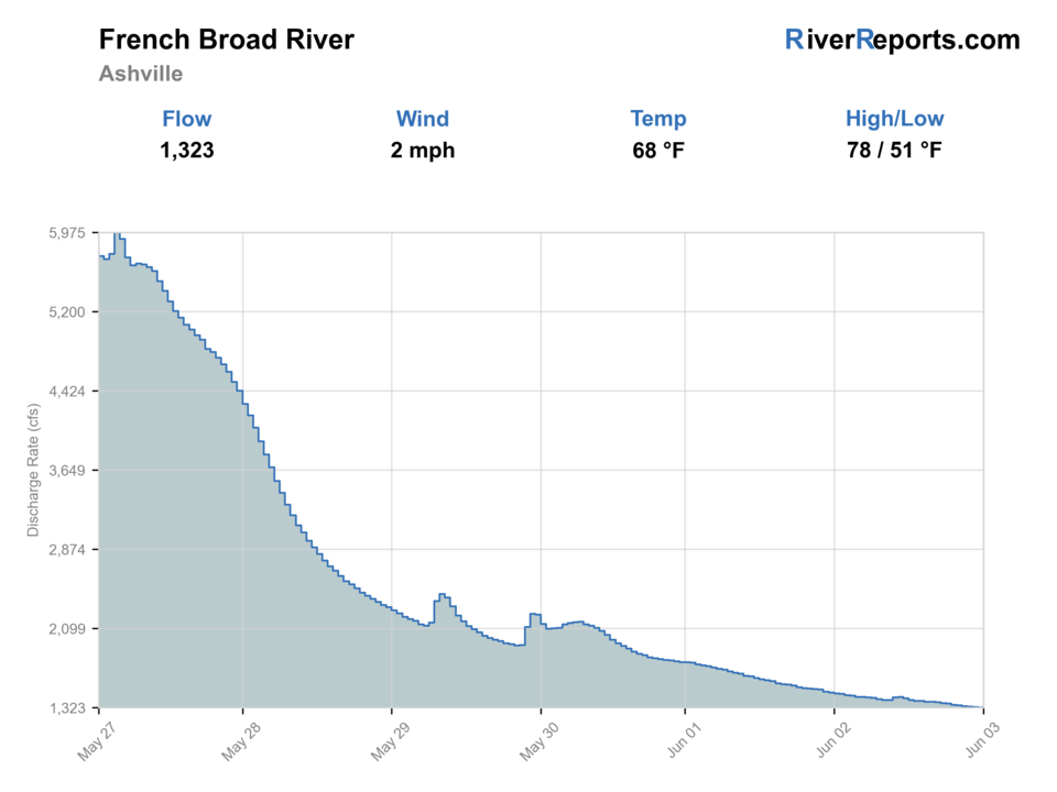
USGS data chart
Official USGS trend
Streamflow over the latest USGS reporting window.
Latest
1,320 cfs
Jun 3, 4 PM UTC
Weather
River weather report
Weather can change wading safety, road access, water temperature, hatches, and the best time of day to fish.
Live forecast loads as you reach this section
This keeps the report fast while still using the official National Weather Service forecast point.
Hatches and flies
Hatch chart and fly picks
March-April
Midges, early mayflies, baitfish movement
Small streamer, soft hackle, pheasant tail
May-June
Caddis, damselflies, crayfish activity
Caddis dry, crayfish, clouser, game changer
July-August
Terrestrials, popper windows, baitfish
Poppers, foam bugs, minnow, crayfish
September-November
Baitfish and crayfish focus
Olive streamer, black streamer, crayfish
Smallmouth streamers
Clouser, bugger, game changer, baitfish
Water is clear enough for fish to track a moving fly.
Topwater
Small popper, stealth bomber, foam slider
Low light, stable summer water, and active bank fish line up.
Bottom and bank flies
Crayfish, hellgrammite, rubber-leg nymph
Bass hold near rocks, ledges, and current breaks.
Tactics
How to fish it
Check the Asheville gauge and recent rainfall before choosing a float, bank, or wade-edge plan.
Fish banks, rock edges, bridge shade, and slower seams before covering open middle water.
Use darker streamers when the river has light stain and natural baitfish colors when it clears.
Treat city access as shared space with paddlers, runners, dogs, and riverfront users.
Rigging
Rod, leader, and setup notes
A 6-weight rod is the most useful all-around French Broad fly rod; use a 7- or 8-weight for larger streamers or muskie-specific work.
Carry 0X through 3X or 10- to 20-pound leaders for bass flies and cover.
A sink-tip or intermediate line helps with deeper banks; a floating line covers poppers and shallow streamers.
Bring sun protection, water shoes or boots, and a dry bag if you are floating.
Access
Access and planning notes
Asheville gauge
Primary big-river trendWade / float / trail
RiverReports / USGS gauge / warmwater
When to pick it
Start here when flow direction, clarity, and debris risk decide the day.
Caution
The gauge does not confirm park status, water quality, float takeouts, or bank access.
French Broad River Park
Urban riverfront baseWade / float / trail
City park / bank / float context
When to pick it
Use it when park access is open and a simple bank or riverfront check fits the flow.
Caution
Urban access can be affected by floods, closures, construction, debris, and crowding.
NCWRC access and where-to-fish tools
Broader access planningWade / float / trail
Access map / bank / float planning
When to pick it
Check these before building a float, alternate access, or backup warmwater plan.
Caution
A broad river corridor still needs confirmed launches, takeouts, parking, and current conditions.
Urban access can change after flood recovery work, construction, or park closures.
High water can carry debris and make takeouts more difficult than the put-in suggested.
Respect other river users and avoid anchoring or fishing across crowded launch areas.
Regulations
Check before fishing
Check NCWRC inland fishing regulations before fishing. Special rules, species limits, and access restrictions can vary by water and season.
Primary base
Asheville, West Asheville, Woodfin, or Bent Creek
Best day style
Urban and near-urban bank, wade-edge, and float planning with water-quality and storm-recovery checks
Check first
RiverReports, USGS 03451500, NCWRC regulations, NCWRC access tools, Asheville park updates, and NWS weather
Safety
High flows, urban debris, storms, heat exposure, cold-water seasons, and changing access after flood or construction work
Gear
Helpful gear for this water
6-weight rod
Best all-around choice for smallmouth streamers, crayfish, and poppers.
Sink-tip line
Useful for deeper banks and ledges.
Polarized glasses
Helps read clarity, rock shelves, and shallow structure.
Dry bag
Useful if you float or fish from mixed riverfront access.
Nearby water
Other water to research
Backup logic
High or muddy water
Compare Davidson, Nantahala, or Catawba pages before forcing poor Asheville clarity.
Debris or float issue
Switch to bank fishing from a confirmed park or choose a different river.
Heat or water-quality concern
Shorten the session, fish early, or wait for safer conditions.
Riverfront access closure
Use NCWRC access tools or pick a trout route with clearer public entry.
Davidson River
A much more trout-focused Pisgah option near Brevard.
Nantahala River
A colder mountain river plan with different flows and trout tactics.
Catawba River
Another larger North Carolina river with tailwater and warmwater decisions.
FAQ
Fast answers
Is French Broad River fishable today?
French Broad River looks very fishable right now. The live score is 96/100, based on current flow, weather, public alerts, and the report's planning context. Recheck the linked gauge and forecast before leaving because conditions can change quickly after rain, heat, access changes, or flow swings.
What flow is best for French Broad River?
Stable to falling flows with enough clarity for streamers and enough safety margin for the access method.
When should I skip French Broad River?
Skip when high, muddy, debris-heavy, stormy, or when riverfront access is closed.
Is French Broad River safe to wade right now?
The fishability score is not a wading guarantee. Wade only where your chosen access has safe edges, clear footing, legal entry, and no forced crossings; high, rising, stained, or storm-affected water should be treated conservatively.
What gauge should I use for the French Broad in Asheville?
Use RiverReports for the quick view and USGS 03451500 at Asheville for the official gauge reference.
Is the French Broad a trout river through Asheville?
For most fly anglers near Asheville, it is better treated as a warmwater smallmouth river. Use nearby trout pages for colder mountain water.
When should I skip the French Broad?
Skip when the river is high, muddy, debris-heavy, or when access parks are closed or under construction.
Sources
Source set for this report
Reviewed 2026-06-02