North Carolina / Southeast
Nantahala River
A Nantahala report for lower gorge flows, upper delayed-harvest context, release safety, public trout rules, access, hatches, and tactics.
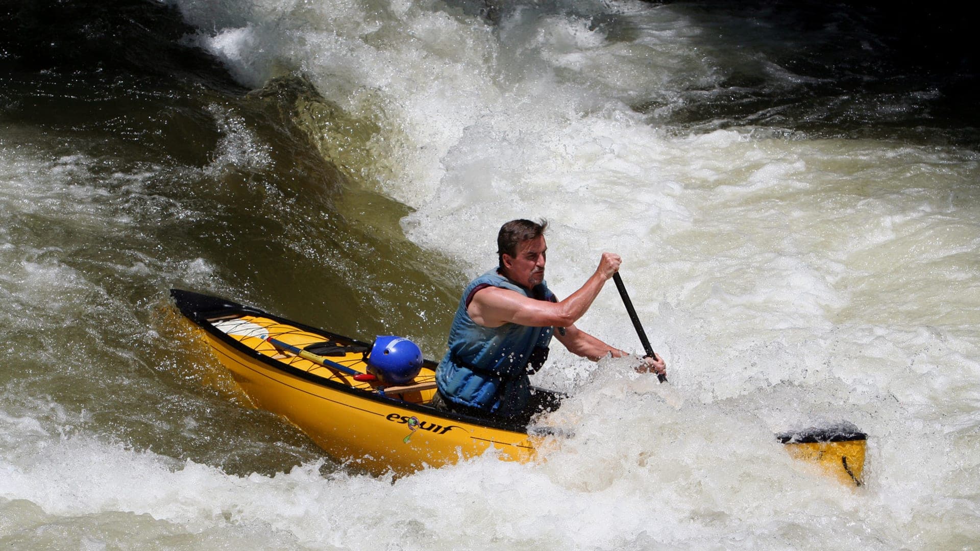
Image: Nantahala River canoeist 2009 / CC BY-SA 2.0 / anoldentFishability now: Nantahala River fishability today
GreatData confidence: High96/100
Fishable now because the live gauge is stable, weather is usable, and no public alert is active.
Flow observed
4:15 PM UTC
Weather observed
5:00 PM UTC
Score calculated
5:26 PM UTC
Why this rating
Flow
Weather
Public alerts
Next 6-12 hours
Hold
Stable live data supports staying with the plan, but recheck the gauge and forecast before leaving.
USGS flow
646 cfs
Current trend: flow stable, so weather, temperature, and access checks drive the next change.
More planning details: flies, flow bands, and live source checks
Fish it today
Start here
Choose upper or lower Nantahala first. Then check Hewitt/Rainbow Springs context, NC Wildlife rules, USFS access, weather, and a second access before rigging.
Best flow clue
Use RiverReports Hewitt and USGS 03505550 for the lower gorge trend, with USGS 03504000 as upper-river context. Match the gauge to the reach you actually plan to fish.
Skip trigger
Skip lower-gorge wading during generation, heavy raft traffic, high/stained water, or when you cannot confirm the current trout-water classification for the reach.
Flow decision bands
Low or technical upper-river water
Lower stable upper-river flows can still fish well, but short wade-first trout sessions and exact delayed-harvest or hatchery-support rules matter more than range-chasing.
Best stable Hewitt trend
Stable Hewitt flow with clear water and no release or raft surprise is the cleanest signal for a practical Nantahala trout plan.
Release, pushy gorge water, or traffic
Generation, heavy raft traffic, or current that removes safe edge water should move the day off the lower gorge instead of forcing a marginal wade.
Rule or reach confusion
A fishable graph still becomes a poor trip when upper-versus-lower reach rules, public-water classification, or the actual access choice are not clear.
USGS flow
646 cfs
Current trend: flow stable, so weather, temperature, and access checks drive the next change.
Live USGS flow
646 cfs / stable
Live NWS forecast
75F / Sunny
Water temperature not verified
Heat guidance uses weather and river type unless an official water-temperature value is available.
No NWS alert flag
No active NWS alert was returned for this forecast point.
Use Hewitt flow for lower gorge planning and Rainbow Springs for upper context.
Check NC Wildlife classifications before choosing flies or harvest expectations.
Hydropower releases and raft traffic can make wading unsafe or impractical.
Carry both small trout flies and heavier nymph or streamer options.
Editorial review
How this report is maintained
This report is maintained from current regulation, access, flow, weather, and public planning sources so anglers can make better trip decisions than a raw gauge or generic overview would allow.
Byline
BlueStreamFly editorial team
Reviewed by
BlueStreamFly source review
Maintained by
Mountain Brook Run LLC
Last material review
2026-05-31
Report confidence
Good confidence
87/100
Good confidence: RiverReports, two USGS gauges, NC Wildlife trout sources, gorge access context, and weather support the page. Confidence is moderated because release timing, raft traffic, and reach-specific classifications still need day-of checks.
Regulations
NC Wildlife trout resources and the public mountain trout water search support delayed-harvest and reach-specific rule checks for the Nantahala.
Access
Nantahala Gorge and Ferebee Memorial access context support public planning for the corridor, with exact bank choice still requiring caution.
Flow and weather
RiverReports Nantahala near Hewitt, USGS 03505550, USGS 03504000, and the National Weather Service point support lower-gorge, upper-river, and weather checks, but release timing still changes the practical call.
Fishing usefulness
The page now separates upper-versus-lower reach choice, release timing, raft traffic, trout-water rules, and backup-water decisions.
Fishability dashboard and source review
2026-05-31 / material content or source review
RiverReports Nantahala near Hewitt, USGS 03505550, USGS 03504000, NC Wildlife trout resources, the public mountain trout water search, Nantahala Gorge and Ferebee Memorial access context, and the National Weather Service point were checked before updating the current-fishability decision layer.
2026-05-31
Updated Nantahala River to the current fishability-page standard with reach-split flow bands, access cards, backup cues, stable fishability SEO, and confidence signals.
2026-05-29
Added Nantahala River trip-fit guidance, Hewitt gauge framing, upper and lower reach planning, delayed-harvest and public mountain trout water reminders, gorge release and raft-traffic safety nuance, backup-water suggestions, editorial review signals, and a page-specific report-confidence meter after source review.
2026-05-24
Initial source-reviewed report published with flows, weather, hatches, flies, tactics, access, regulations, and FAQs.
Angler planning edge
Local details that change the plan
Best for
Western North Carolina trout anglers choosing between upper delayed-harvest water and the lower release-driven gorge, Trips where the first decision is reach and flow, not fly pattern, Anglers who can check hydropower-influenced conditions, raft traffic, and public mountain trout water rules before wading, Spring and fall trout plans that need a colder-water backup when nearby freestones are warm or muddy
Wade or float
Treat the Nantahala as two different plans. Upper trout water is mostly wade-first, while the lower gorge requires release, traffic, and safe-bank decisions before stepping in.
Best flows
Use RiverReports Hewitt and USGS 03505550 for the lower gorge trend, with USGS 03504000 as upper-river context. Match the gauge to the reach you actually plan to fish.
When to skip
Skip lower-gorge wading during generation, heavy raft traffic, high/stained water, or when you cannot confirm the current trout-water classification for the reach.
Local plan
Choose upper or lower Nantahala first. Then check Hewitt/Rainbow Springs context, NC Wildlife rules, USFS access, weather, and a second access before rigging.
Pressure
Pressure shifts by season and reach. Delayed-harvest water draws trout anglers, while the gorge can be dominated by whitewater traffic during release windows.
Access nuance
USFS gorge and picnic-area sources are useful anchors, but the river corridor is narrow and reach-specific. Avoid treating every roadside pullout as a safe fishing access.
Backup water
If the Nantahala is releasing, crowded, or rule-complicated, compare Davidson River, New River, or nearby Georgia tailwater reports before forcing the gorge.
About the river
Setting, character, and why it fishes the way it does.
The Nantahala River is one of western North Carolina's signature trout rivers, with upper mountain water and a lower gorge that is also famous for whitewater.
The upper river includes delayed-harvest and hatchery-supported context, while the lower river below hydropower influence requires careful flow and release planning.
A helpful fishing page should prevent the common mistake: showing up with one plan for a river that actually has several different legal, flow, and access personalities.
Target species
Rainbow trout
Important in stocked and managed trout water.
Brown trout
Present in deeper runs, cover, and lower river structure.
Brook trout
More likely in colder upper and tributary-influenced water.
Smallmouth bass
Possible in warmer lower watershed context, not the main trout report focus.
Reading the water
No/low generation
More wading options can open in the gorge, but still check footing and traffic.
Generation or high water
Avoid wading the main push; fish banks or choose upper water.
Upper delayed-harvest flow
Dry-dropper and nymph rigs can cover riffles and plunge pools.
Warm weather
Check temperature and fish early or higher/colder water.
Best seasons
Spring
Delayed-harvest stocking, caddis, BWOs, sulphurs, and active nymphing.
Summer
Early, shaded, or release-aware windows; watch heat and rafting pressure.
Fall
Delayed-harvest and cooler water create good trout opportunities.
Winter
Midges and nymphs can work when access and roads are safe.
Preferred flow source
Nantahala River near Hewitt
RiverReports is the preferred chart source when coverage exists. When a matching USGS gauge exists, keep it open as the official backstop for station data and current hydrograph context.
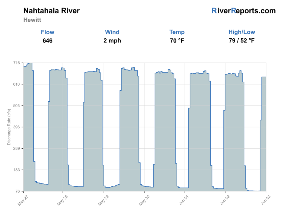
USGS data chart
Official USGS trend
Streamflow over the latest USGS reporting window.
Latest
646 cfs
Jun 3, 4 PM UTC
Weather
River weather report
Weather can change wading safety, road access, water temperature, hatches, and the best time of day to fish.
Live forecast loads as you reach this section
This keeps the report fast while still using the official National Weather Service forecast point.
Hatches and flies
Hatch chart and fly picks
February to March
Midges, early black stones, BWOs, and early caddis
Zebra midge, black stonefly nymph, BWO emerger, caddis pupa
April to May
Caddis, sulphurs, March Browns, yellow sallies, and golden stones
Elk hair caddis, sulphur emerger, March Brown, yellow sally, Pat's rubber legs
June to August
Terrestrials, small caddis, midges, and attractor dry-dropper food
Foam ant, beetle, small hopper, parachute Adams, pheasant tail dropper
September to November
BWOs, October caddis, midges, and streamer windows after rain
BWO emerger, October caddis, zebra midge, soft hackle, small sculpin
Nymphs
Pheasant tail, hare's ear, caddis pupa, zebra midge, perdigon
Use when trout are low, current is broken, or the hatch has not started.
Dry flies
BWO, caddis, parachute Adams, sulphur, terrestrial
Use when fish rise, bugs collect in soft seams, or shaded banks are active.
Streamers
Sculpin, leech, woolly bugger, small baitfish
Use in stain, cloud cover, higher water, or deeper edge water.
Soft hackles
Partridge and orange, pheasant tail soft hackle, caddis soft hackle
Swing riffles, tailouts, and current tongues when insects are moving.
Tactics
How to fish it
Separate upper river, delayed-harvest, and lower gorge plans before rigging.
Fish small nymphs and dry-droppers in upper pocket water.
Use heavier nymphs or streamers in the gorge only when flows allow safe presentations.
Avoid standing in main current during generation or raft releases.
Scout pull-offs and trails before committing to a long roadside walk.
Rigging
Rod, leader, and setup notes
A 4-weight works well for upper trout water; a 5-weight is better for the gorge.
Carry indicator and dry-dropper rigs for changing depth.
Use 4X to 6X tippet for trout; go heavier for streamers in faster water.
Bring a wading staff and secure pack in the gorge.
Pack rain gear because mountain storms arrive quickly.
Access
Access and planning notes
Hewitt gauge and lower-gorge check
Primary lower-river decisionWade / float / trail
Gauge / roadside scout
When to pick it
Start here when lower-gorge trend, current speed, and traffic decide whether the Nantahala should stay the main plan at all.
Caution
A useful gauge does not remove release timing, whitewater traffic, or tight-bank access concerns in the gorge.
Upper-river trout corridor
Wade-first technical planWade / float / trail
Walk-and-wade / scout
When to pick it
Pick it when you want a simpler upper-river trout day and current rules and access are clearly confirmed for the reach.
Caution
Upper-water classifications and named public access still need current sign and map checks before rigging.
Gorge picnic and public-corridor access
Release-aware backup stopWade / float / trail
Roadside / walk-and-wade
When to pick it
Use it only when release timing, raft traffic, and safe bank access all line up for a shorter lower-river session.
Caution
Do not treat every roadside pullout as equal public access or safe wading just because the river is visible.
Upper and lower Nantahala reaches are not interchangeable; check rules and flow for the exact water.
Raft traffic can make midday lower-gorge fly fishing less effective and less safe.
USFS access can be affected by weather, road work, and storm recovery.
Regulations
Check before fishing
NC Wildlife public mountain trout water classifications apply by reach, including delayed-harvest context on the upper river. Confirm current signs before fishing.
Primary base
Bryson City, Franklin, Andrews, or Robbinsville
Best day style
USFS gorge access, hydropower release planning, delayed-harvest reach context, and roadside water
Check first
Hewitt flow, upper/lower reach choice, NC trout classification, release schedule, and raft traffic
Safety
Hydropower changes, cold water, raft traffic, slick boulders, and narrow gorge access
Gear
Helpful gear for this water
4-weight or 5-weight rod
Covers most dry-fly, nymph, and small-streamer work.
Thermometer
Important for summer trout ethics and reach selection.
Wading staff
Useful on slick cobble, ledge rock, and higher water.
Public-access map
Helps avoid posted land and makes the day more efficient.
Nearby water
Other water to research
Backup logic
Release or raft traffic
Move to Davidson, New River, or another cooler trout option instead of forcing the lower gorge during a bad window.
High or stained water
Let the river settle or pick an upper reach or another tailwater before forcing pushy current.
Warm water
Keep trout sessions centered on cool periods and stop handling fish when the coldwater margin disappears.
Rule or access issue
Treat unclear trout-water classification or public access as a stop signal before fishing either reach.
Davidson River
A technical Brevard trout option with a different access style.
New River
A mountain smallmouth plan when you want warmwater fishing.
Toccoa River
A southern trout river with tailwater and delayed-harvest planning.
FAQ
Fast answers
Is Nantahala River fishable today?
Nantahala River looks very fishable right now. The live score is 96/100, based on current flow, weather, public alerts, and the report's planning context. Recheck the linked gauge and forecast before leaving because conditions can change quickly after rain, heat, access changes, or flow swings.
What flow is best for Nantahala River?
Use RiverReports Hewitt and USGS 03505550 for the lower gorge trend, with USGS 03504000 as upper-river context. Match the gauge to the reach you actually plan to fish.
When should I skip Nantahala River?
Skip lower-gorge wading during generation, heavy raft traffic, high/stained water, or when you cannot confirm the current trout-water classification for the reach.
Is Nantahala River safe to wade right now?
The fishability score is not a wading guarantee. Wade only where your chosen access has safe edges, clear footing, legal entry, and no forced crossings; high, rising, stained, or storm-affected water should be treated conservatively.
What should I check before fishing the Nantahala River?
Check Hewitt flow, upper/lower reach choice, NC trout classification, release schedule, and weather.
Are there special regulations on the Nantahala River?
Yes. Rules vary by reach, including delayed-harvest and hatchery-supported water.
Can I wade the Nantahala River?
Sometimes. The lower gorge can be unsafe during generation or heavy raft traffic; upper water is a different plan.
What flies should I bring for the Nantahala River?
Bring the seasonal hatch box, a nymph box, a few streamers, and a backup plan for clear, high, warm, or crowded water.
Sources
Source set for this report
Reviewed 2026-05-31