
New Mexico / Southwest
Brazos River
A high-country Brazos River report for anglers checking runoff, Carson National Forest access, trout timing, and simple freestone tactics before committing to the canyon.
Image: Generated regional planning image for Brazos River / BlueStreamFly generated; not exact location / BlueStreamFlyFishability now: Brazos River fishability today
GreatData confidence: High96/100
Fishable now because Fishtail Road gauge is stable, weather is mild, and no public alert is active.
Flow observed
4:15 PM UTC
Weather observed
5:00 PM UTC
Score calculated
5:24 PM UTC
Why this rating
Flow
Weather
Public alerts
Next 6-12 hours
Hold
Stable live data supports staying with the plan, but recheck the gauge and forecast before leaving.
USGS flow
35 cfs
Current trend: flow stable, so weather, temperature, and access checks drive the next change.
More planning details: flies, flow bands, and live source checks
Fish it today
Start here
Base from Tierra Amarilla or Chama, check the gauge first, then decide whether the Brazos beats the Chama or San Juan for the day.
Best flow clue
Stable or gently falling flows that leave visible seams, safe bank entries, and enough clarity to read pocket water.
Skip trigger
Skip during sharp runoff spikes, muddy monsoon color, lightning, or when the access road is becoming the main risk.
Flow decision bands
Stable clear pocket water
Stable or slowly falling Fishtail Road flow is the best sign that pockets, soft banks, and short dry-dropper seams can fish safely.
Runoff spike
High or rising runoff should move the day to protected-edge scouting or a different northern New Mexico river.
Low clear high-country water
Low clear water can fish early or late with longer leaders, but trout handling and stealth matter.
Monsoon color or road issue
Storm color, lightning, or muddy roads can make the canyon a poor choice even when the gauge looks tempting.
USGS flow
35 cfs
Current trend: flow stable, so weather, temperature, and access checks drive the next change.
Live USGS flow
35 cfs / stable
Live NWS forecast
67F / Partly Sunny
Water temperature not verified
Heat guidance uses weather and river type unless an official water-temperature value is available.
No NWS alert flag
No active NWS alert was returned for this forecast point.
RiverReports is the quick chart, backed by USGS 08282300 Rio Brazos at Fishtail Road near Tierra Amarilla.
Carson National Forest access is real but spread out, so campground pull-ins and forest roads matter more than one single famous parking area.
New Mexico rules change by water type and special-trout designation, so check the current NMDGF fishing rules before assuming harvest or gear details.
Runoff, afternoon storms, and slick basalt or cobble can turn a promising freestone plan into a scouting day.
Editorial review
How this report is maintained
This report starts with official regulation, flow, weather, and public-access sources, then adds practical planning guidance for fly anglers.
Byline
BlueStreamFly editorial desk
Reviewed by
BlueStreamFly source review
Maintained by
BlueStreamFly
Last material review
2026-06-02
Report confidence
Good confidence
88/100
Good confidence: RiverReports, USGS 08282300 at Fishtail Road, New Mexico fishing rules, Carson National Forest recreation sources, Rio de Los Pinos Campground access, weather coverage, generated media disclosure, and route-specific Brazos freestone guidance support the page. Confidence is moderated by runoff timing, monsoon color, road conditions, exact access status, and reach-specific trout rules.
Regulations
New Mexico fishing rules sources support current rule and special-water checks.
Access
Carson National Forest and Rio de Los Pinos sources support public access planning, while road and site status remain day-specific.
Flow and weather
RiverReports, USGS 08282300 at Fishtail Road, and the National Weather Service point support live flow and weather decisions.
Fishing usefulness
The page now separates freestone runoff, monsoon stain, Carson access, road condition, high-country wading safety, warm-water stops, and northern New Mexico backups.
Fishability dashboard and source review
2026-06-02 / material content or source review
RiverReports and USGS 08282300 Rio Brazos at Fishtail Road flow, New Mexico fishing rules, Carson National Forest recreation and Rio de Los Pinos Campground access, National Weather Service data, and route-specific runoff and monsoon guidance were checked before updating the current-fishability decision layer.
2026-06-02
Updated the Brazos River with high-country freestone flow bands, Carson access cards, backup cues, and confidence signals.
2026-05-26
Published a new Brazos River report with flow-first freestone planning, public-access notes, hatch timing, and runoff safety guidance.
Angler planning edge
Local details that change the plan
Best for
High-country freestone trout days, Dry-dropper fishing, Flexible northern New Mexico trip planning
Wade or float
This is mainly a wade report. Treat elevated runoff as a no-wade condition and pivot early.
Best flows
Stable or gently falling flows that leave visible seams, safe bank entries, and enough clarity to read pocket water.
When to skip
Skip during sharp runoff spikes, muddy monsoon color, lightning, or when the access road is becoming the main risk.
Local plan
Base from Tierra Amarilla or Chama, check the gauge first, then decide whether the Brazos beats the Chama or San Juan for the day.
Pressure
Roadside pull-ins can get attention. Walk a little, fish the second seam, and do not camp on the first obvious pool.
Access nuance
Forest access is helpful but not uniform. Expect changing road quality, limited parking, and a need to respect signed boundaries.
Backup water
Chama River, San Juan River, and Pecos River pages offer better backup options than forcing a bad Brazos day.
About the river
Setting, character, and why it fishes the way it does.
The Rio Brazos is high-country northern New Mexico trout water with a mix of meadow bends, pocket-water banks, and forest-road access rather than one obvious tailwater program.
That freestone character makes the river fun when conditions line up and unforgiving when they do not. You are planning around snowmelt, thunderstorms, and how much fishable edge the river leaves from one day to the next.
The river also sits in the broader Carson landscape, so a good day often means pairing the gauge with campground access, road conditions, and a backup plan before you leave town.
Target species
Brown trout
A practical target in stable pocket water and deeper bends.
Rainbow trout
Part of the common high-country trout mix where flows and temperature stay favorable.
Rio Grande cutthroat trout
Native-trout context matters in the drainage; verify reach-specific rules and handle fish carefully.
Reading the water
Stable medium flow
Best for dry-dropper rigs, pocket-water nymphing, and covering short seams.
High runoff
Skip aggressive wading and fish only soft edges if clarity and access still make sense.
Low clear water
Lengthen leaders, fish early or late, and keep the first cast the best cast.
Monsoon color
Use darker nymphs or a small streamer and stay close to protected banks.
Best seasons
Late spring
Watch runoff closely; fish when the hydrograph settles enough for safe edge water.
Summer
Often the best dry-dropper and attractor window if storms stay manageable.
Early fall
Cooler nights and steadier flows often improve trout handling and consistency.
Winter
More of a niche cold-water plan than a broad recommendation.
Preferred flow source
Rio Brazos at Fishtail Road
RiverReports is the preferred chart source when coverage exists. When a matching USGS gauge exists, keep it open as the official backstop for station data and current hydrograph context.
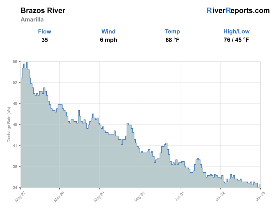
USGS data chart
Official USGS trend
Streamflow over the latest USGS reporting window.
Latest
35 cfs
Jun 3, 4 PM UTC
Weather
River weather report
Weather can change wading safety, road access, water temperature, hatches, and the best time of day to fish.
Live forecast loads as you reach this section
This keeps the report fast while still using the official National Weather Service forecast point.
Hatches and flies
Hatch chart and fly picks
May-June
Stoneflies, caddis, early mayflies
Stimulator, elk hair caddis, hare's ear, stonefly nymph
June-July
PMDs, caddis, yellow sallies
PMD emerger, caddis dry, yellow stimulator, perdigon
July-August
Terrestrials, caddis, small mayflies
Foam ant, beetle, hopper-dropper, X-caddis
September-October
BWOs, midges, caddis
BWO emerger, zebra midge, soft hackle, olive bugger
Dry-dropper staples
Stimulator, chubby, elk hair caddis, pheasant tail, perdigon
Pocket water is clear enough to read and trout will move up in broken current.
Freestone nymphs
Hare's ear, prince, stonefly nymph, caddis pupa
Cold mornings or faster seams keep fish deeper.
Small streamers
Olive bugger, black bugger, small sculpin
Cloud cover, colored water, or deeper bends favor a bigger profile.
Tactics
How to fish it
Start at the gauge, then choose a reach that matches the current speed rather than forcing a full-day commitment.
Cover short pockets and soft banks carefully instead of standing in the middle and casting long.
If runoff or storms add too much color, fish the first quiet seam off the bank or move to another river.
Warm afternoons are usually less valuable than cool mornings and evening shade on this river.
Rigging
Rod, leader, and setup notes
A 4- or 5-weight rod covers almost every Brazos trout plan.
Carry 4X through 6X tippet, plus 3X for streamers or heavier indicator rigs.
Use a wading staff on slick rock and whenever the river is even slightly above its comfortable summer shape.
Pack a rain shell and thermometer because weather and trout ethics can change fast.
Access
Access and planning notes
Fishtail Road corridor
Gauge-area scoutWade / float / trail
Roadside / walk-wade
When to pick it
Start here when you need to compare the live flow with clarity, road condition, and first safe entries.
Caution
Runoff and storms can make the way out worse than the way in.
Carson National Forest roadside access
Primary public frameworkWade / float / trail
Forest road / campground / walk-wade
When to pick it
Use it when public access, road condition, and wading safety all line up.
Caution
Forest access is useful but not uniform; parking and road quality vary.
Rio de Los Pinos Campground area
Camp-based backup contextWade / float / trail
Campground / nearby public access
When to pick it
Pick it when campground logistics make a short public-water session more realistic.
Caution
Check current site status and do not assume every nearby bank is open.
Treat forest-road pull-ins as variable access, not guaranteed easy wading.
Mud, runoff, and afternoon storms can make a good-looking access point worse on the way out than it was on the way in.
Stay on clearly public access and do not assume every roadside opening is legal parking or fishing access.
Regulations
Check before fishing
Confirm current New Mexico fishing rules and any special-trout-water restrictions before fishing. This page is a planning aid, not a substitute for the current NMDGF digest or posted site rules.
Primary base
Tierra Amarilla, Chama, or Tres Piedras area lodging and camp access
Best day style
Forest-road, campground, and roadside freestone access with runoff-sensitive wading
Check first
RiverReports, USGS 08282300, NMDGF fishing rules, Carson access conditions, and the NWS forecast
Safety
Runoff, monsoon lightning, slick rock, muddy roads, and cold-water wading hazards
Gear
Helpful gear for this water
4- or 5-weight rod
A practical freestone setup for dries, nymphs, and small streamers.
Wading staff
Useful whenever runoff or slick pocket-water ledges raise the risk.
Thermometer
Helps judge whether late-day trout handling is still responsible.
Rain shell
High-country storms can arrive fast even on a calm start.
Nearby water
Other water to research
Backup logic
Runoff or monsoon color
Move to Chama, San Juan, or Pecos instead of forcing stained pocket water.
Muddy or deteriorating road
Shorten the trip or choose a more reliable access plan before the exit becomes the problem.
Warm afternoon
Fish cooler windows only and stop trout fishing before handling stress builds.
Rule or special-water uncertainty
Confirm current New Mexico fishing rules before choosing tackle, harvest, or reach.
Chama River
A more release-influenced northern New Mexico option.
San Juan River
The state's best-known tailwater when you want a different style of trout day.
Pecos River
Another mountain freestone and access-driven trout plan.
FAQ
Fast answers
Is Brazos River fishable today?
Brazos River looks very fishable right now. The live score is 96/100, based on current flow, weather, public alerts, and the report's planning context. Recheck the linked gauge and forecast before leaving because conditions can change quickly after rain, heat, access changes, or flow swings.
What flow is best for Brazos River?
Stable or gently falling flows that leave visible seams, safe bank entries, and enough clarity to read pocket water.
When should I skip Brazos River?
Skip during sharp runoff spikes, muddy monsoon color, lightning, or when the access road is becoming the main risk.
Is Brazos River safe to wade right now?
The fishability score is not a wading guarantee. Wade only where your chosen access has safe edges, clear footing, legal entry, and no forced crossings; high, rising, stained, or storm-affected water should be treated conservatively.
What gauge should I check for the Brazos River?
Use RiverReports for the quick chart and USGS 08282300 at Fishtail Road near Tierra Amarilla for the official gauge reference.
Is the Brazos mostly a wade river?
Yes, most visiting fly anglers plan to wade short sections from roadside or campground access, but runoff can take that option away quickly.
When should I skip the Brazos?
Skip when flows are rising, the river is carrying too much color, thunderstorms are building, or the access road you need is clearly deteriorating.
Sources
Source set for this report
Reviewed 2026-06-02