New Mexico / Southwest
Pecos River
An upper Pecos Canyon report for trout water near Pecos, Terrero, and Cowles, with flow, hatches, access, regulations, and safety checks.
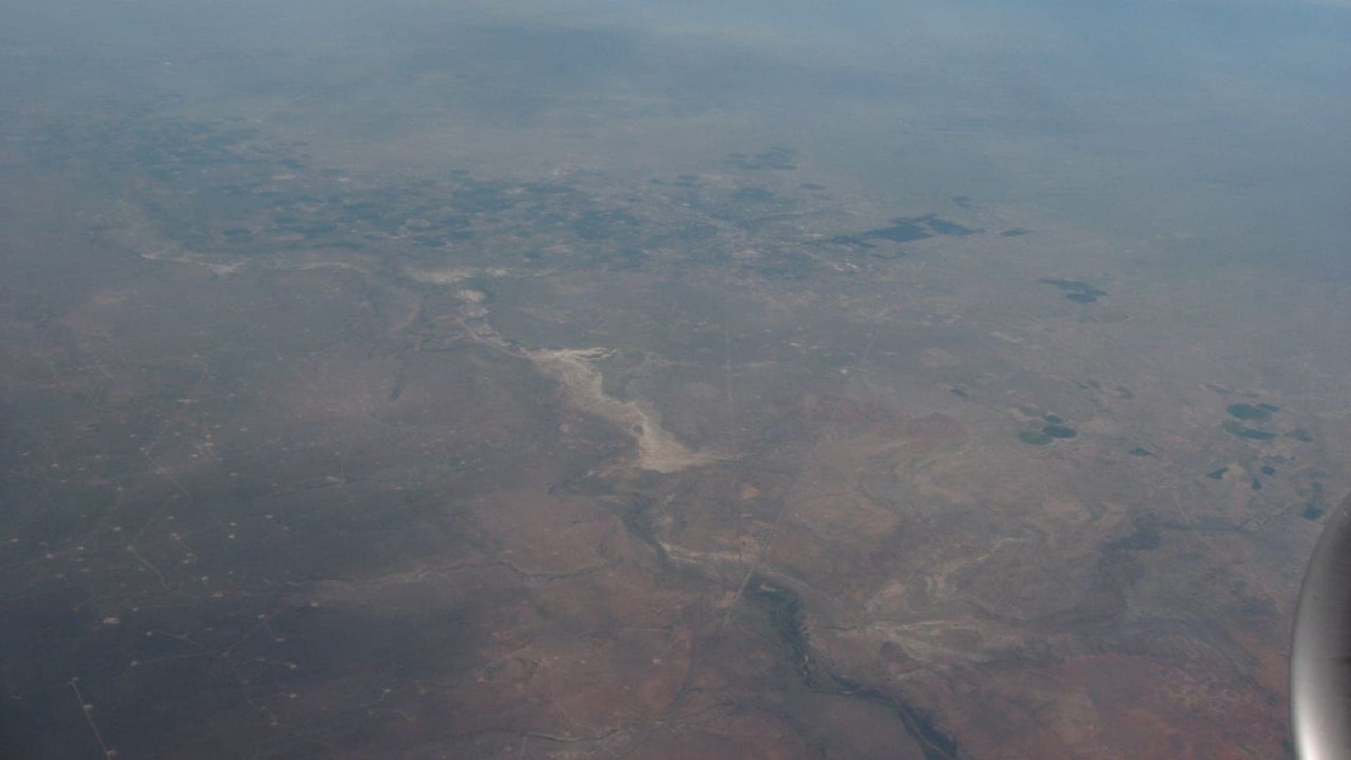
Image: Pecos River heading towards Roswell, New Mexico (2912314765) / CC BY-SA 2.0 / Ken Lund from Reno, Nevada, USAFishability now: Pecos River fishability today
GreatData confidence: High86/100
Fishable now because the live gauge is stable, weather is mild, and no public alert is active.
Flow observed
5:00 PM UTC
Weather observed
5:00 PM UTC
Score calculated
5:25 PM UTC
Why this rating
Flow
Weather
Short-term weather
Next 6-12 hours
Watch
Recheck within the next few hours; rising water or active weather can change clarity and wading quickly.
USGS flow
32 cfs
Current trend: flow stable, so weather, temperature, and access checks drive the next change.
More planning details: flies, flow bands, and live source checks
Fish it today
Start here
Check the near-Pecos flow, New Mexico rules, NMDGF updates, park access requirements, and weather first, then fish short precise drifts through shaded pocket water and pool tails.
Best flow clue
Use RiverReports and USGS 08378500 near Pecos as the main trend for upper-canyon planning, then check monsoon rain, runoff, road status, and reach access before fishing.
Skip trigger
Skip the canyon when runoff is pushy, monsoon stain cuts visibility, wildfire or flood closures are active, water is warm, or the plan depends on park water without a reservation.
Flow decision bands
Low and clear
Low clear upper Pecos water can still fish, but shorter drifts, light tippet, and cool-hour trout handling matter more than chasing every campground pullout.
Best near-Pecos trend
Stable or slowly dropping near-Pecos flow with clear water is the cleanest signal for dry-droppers, nymphs, caddis, and pocket-water trout fishing.
Runoff or monsoon stain
Pushy runoff or muddy monsoon water should move the day off the river instead of forcing blind drifts through unsafe canyon current.
Closure or heat caution
A fishable graph still loses value when wildfire closures, reservation-only access, or summer warmth remove the practical trout window.
USGS flow
32 cfs
Current trend: flow stable, so weather, temperature, and access checks drive the next change.
Live USGS flow
32 cfs / stable
Live NWS forecast
64F / Slight Chance Showers And Thunderstorms
Water temperature not verified
Heat guidance uses weather and river type unless an official water-temperature value is available.
No NWS alert flag
No active NWS alert was returned for this forecast point.
Use the near-Pecos gauge before choosing a reach or wading plan.
Expect fast pocket water, short drifts, and quick adjustments after storms.
Bring attractor dries, caddis, mayflies, small stoneflies, and weighted nymphs.
Use NMDGF, NPS, and public-land sources because access changes by reach.
Editorial review
How this report is maintained
This report is maintained from current regulation, access, flow, weather, and public planning sources so anglers can make better trip decisions than a raw gauge or generic overview would allow.
Byline
BlueStreamFly editorial team
Reviewed by
BlueStreamFly source review
Maintained by
Mountain Brook Run LLC
Last material review
2026-05-31
Report confidence
Good confidence
89/100
Good confidence: RiverReports, USGS near-Pecos flow, New Mexico regulations, Pecos National Historical Park fishing information, Rivers.gov background, NMDGF updates, and weather support the page. Confidence is moderated by closures, reservation access, and upper-versus-lower river scope.
Regulations
New Mexico rule and general regulation sources support the legal-check path for upper Pecos trout planning.
Access
Pecos National Historical Park and Rivers.gov sources support public-access and river-scope guidance, with exact reach access still requiring day-of checks.
Flow and weather
RiverReports Pecos near Pecos, USGS 08378500, and the National Weather Service point provide a strong live planning set.
Fishing usefulness
The page now separates upper-canyon scope, runoff and monsoon timing, closure risk, access boundaries, and backup-water decisions.
Fishability dashboard and source review
2026-05-31 / material content or source review
RiverReports Pecos near Pecos, USGS 08378500, New Mexico rules, Pecos National Historical Park fishing information, Rivers.gov scope guidance, NMDGF weekly updates, and the National Weather Service point were checked before updating the current-fishability decision layer.
2026-05-31
Updated Pecos River to the current fishability-page standard with upper-canyon flow bands, access cards, backup cues, stable fishability SEO, and confidence signals.
2026-05-29
Added Pecos River trip-fit guidance, near-Pecos RiverReports and USGS source framing, upper-canyon scope reminders, Pecos National Historical Park reservation nuance, wildfire and monsoon safety planning, backup-water suggestions, editorial review signals, and a page-specific report-confidence meter after source review.
2026-05-24
Initial source-reviewed report published with flows, weather, hatches, flies, tactics, access, regulations, and FAQs.
Angler planning edge
Local details that change the plan
Best for
Santa Fe and northern New Mexico anglers focused on upper Pecos Canyon trout water rather than the full lower Pecos system, Pocket-water dry-dropper, nymph, caddis, mayfly, terrestrial, and light-streamer fishing after runoff settles, Trips where road status, wildfire closures, monsoon clarity, and public versus reservation access need a direct check, Anglers who will protect trout during warm afternoons and move to another water when canyon conditions are unsafe
Wade or float
Treat this report as wade-first upper Pecos Canyon trout water. Short pocket-water sessions work best when flow, clarity, road status, and legal access all line up.
Best flows
Use RiverReports and USGS 08378500 near Pecos as the main trend for upper-canyon planning, then check monsoon rain, runoff, road status, and reach access before fishing.
When to skip
Skip the canyon when runoff is pushy, monsoon stain cuts visibility, wildfire or flood closures are active, water is warm, or the plan depends on park water without a reservation.
Local plan
Check the near-Pecos flow, New Mexico rules, NMDGF updates, park access requirements, and weather first, then fish short precise drifts through shaded pocket water and pool tails.
Pressure
Pressure concentrates near NM 63 access, campgrounds, and easy canyon pullouts. Early starts and a second legal reach help avoid crowded pocket water.
Access nuance
Public-land, campground, private, and Pecos National Historical Park access are not interchangeable. Confirm open roads, closures, and reservation requirements before driving in.
Backup water
If the Pecos is high, muddy, closed, warm, or crowded, compare the Cimarron, Chama, or San Juan based on whether a freestone or tailwater plan fits better.
About the river
Setting, character, and why it fishes the way it does.
The Pecos River begins high in the Sangre de Cristo Mountains and becomes one of New Mexico's classic mountain trout streams before it eventually turns into a much different lower-river system.
For fly anglers near Santa Fe, the useful fishery is the upper canyon: fast pocket water, campground access, public-land sections, and cold tributary influence near the mountains.
This page intentionally does not treat the full lower Pecos as one trout report. A good upper Pecos plan is about flow, clarity, legal access, closures, and keeping presentations short and accurate.
Target species
Brown trout
A common target around undercut banks, plunge pools, and deeper pockets.
Rainbow trout
Present in stocked and managed coldwater reaches.
Rio Grande cutthroat trout
Important native trout context in the headwaters and protected waters.
Brook trout
Possible in colder tributary and high-elevation water.
Reading the water
Clear and moderate
Fish dry-droppers, pocket nymph rigs, and small attractor dries.
Runoff high
Stay out of pushy current and wait for safer, clearer edges.
Monsoon stain
Fish protected banks with darker nymphs or small streamers, or wait for clarity.
Summer warmth
Fish early, carry a thermometer, and stop trout handling when water warms.
Best seasons
Spring
Can be strong before heavy runoff, with nymphs and early hatches.
Early summer
Runoff drop brings caddis, mayflies, and better pocket-water access.
Late summer
Terrestrials and morning water matter, but monsoon storms can change clarity fast.
Fall
Cooler water, lighter crowds, BWOs, and small streamers can be useful.
Preferred flow source
Pecos River near Pecos
RiverReports is the preferred chart source when coverage exists. When a matching USGS gauge exists, keep it open as the official backstop for station data and current hydrograph context.
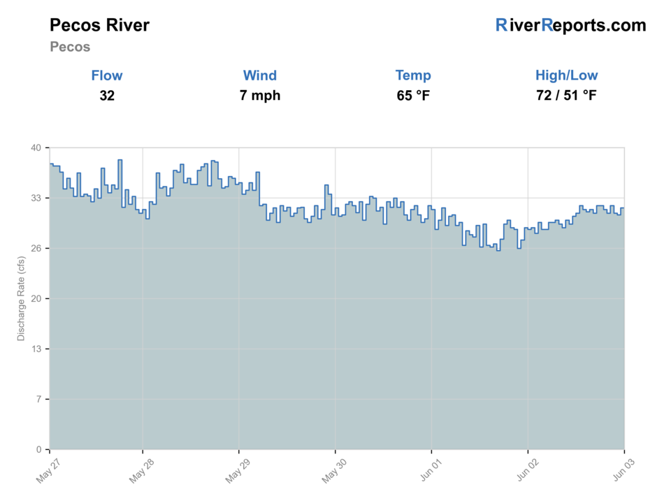
USGS data chart
Official USGS trend
Streamflow over the latest USGS reporting window.
Latest
32 cfs
Jun 3, 5 PM UTC
Weather
River weather report
Weather can change wading safety, road access, water temperature, hatches, and the best time of day to fish.
Live forecast loads as you reach this section
This keeps the report fast while still using the official National Weather Service forecast point.
Hatches and flies
Hatch chart and fly picks
March to April
Midges, BWOs, early caddis, and small stoneflies
Zebra midge, RS2, BWO emerger, caddis pupa, small black stonefly
May to June
Caddis, PMDs, yellow sallies, golden stones, and runoff-edge bugs
Elk hair caddis, PMD emerger, yellow sally, Pat's rubber legs, hare's ear
July to September
Terrestrials, caddis, tricos, midges, and small mayflies
Foam ant, beetle, hopper-dropper, trico spinner, parachute Adams
October to winter
Midges, BWOs, eggs where legal, leeches, and low-light streamer windows
Midge pupa, BWO, egg pattern where legal, leech, small sculpin
Nymphs
Pheasant tail, hare's ear, caddis pupa, zebra midge, perdigon
Use when fish are low, current is broken, or the hatch has not started yet.
Dry flies
BWO, caddis, parachute Adams, sulphur, terrestrial
Use when fish rise, bugs collect in soft seams, or summer banks have shade.
Streamers
Sculpin, leech, woolly bugger, small baitfish
Use in stain, cloud cover, higher water, or deeper edge water.
Soft hackles
Partridge and orange, pheasant tail soft hackle, caddis soft hackle
Swing riffles, tailouts, and current tongues when insects are moving.
Tactics
How to fish it
Fish upstream with short casts so the first drift through each pocket is clean.
Use a buoyant dry and a small weighted dropper when fish are spread through pocket water.
High-stick fast slots with a compact nymph rig instead of long indicator drifts.
Cover shaded banks and plunge-pool tails before walking through them.
After a thunderstorm, give the river time to clear instead of forcing unsafe wades.
Rigging
Rod, leader, and setup notes
A 4-weight or 5-weight rod is ideal for the upper canyon.
Use 4X to 6X tippet and carry enough weight for plunge pools.
Keep leaders shorter than big-river rigs because casts are close and brushy.
Bring a wading staff for slick canyon rocks and pushy runoff flows.
Use barbless hooks and quick releases, especially during warm afternoons.
Access
Access and planning notes
NM 63 and campground corridor
Primary upper-canyon planWade / float / trail
Walk-and-wade / scout
When to pick it
Use it when the upper canyon is clear, open, and cool enough for a short public-access trout session.
Caution
Easy camp and roadside access can mean quick crowding and uneven legal-bank opportunities.
Terrero to Cowles reach
Pocket-water trout dayWade / float / trail
Walk-and-wade
When to pick it
Pick it when the flow is settled and you want the classic upper Pecos pocket-water character.
Caution
Monsoon color and slick rocks can turn the best-looking pocket into a poor wading choice quickly.
Pecos National Historical Park
Reservation-only backupWade / float / trail
Reservation access / walk-and-wade
When to pick it
Use it only when the reservation program is confirmed and the selected water matches the day better than the open canyon corridor.
Caution
Do not treat the park as open walk-in access without a current reservation and rule check.
Check wildfire, flood, and road status before driving into the canyon.
Some attractive banks are private or reservation-controlled; confirm public access before fishing.
The Pecos can be crowded near campgrounds, so a flexible reach plan helps.
Regulations
Check before fishing
New Mexico rules include Special Trout Water, winter trout, and reach-specific notes in the Pecos drainage. Check the current NMDGF rule book, and follow NPS reservation rules if fishing Pecos National Historical Park.
Primary base
Pecos, Santa Fe, Las Vegas, or Cowles
Best day style
Roadside canyon access, campgrounds, public land, and reservation-only park water
Check first
Pecos flow, fire/closure status, NMDGF rules, NPS reservations if used, and road weather
Safety
Runoff, monsoon stain, private boundaries, wildfire closures, and cold pocket water
Gear
Helpful gear for this water
4-weight or 5-weight rod
Covers most dry-fly, nymph, and light streamer work.
Long leaders
Clear water and pressured fish reward 9 to 12 foot leaders.
Wading staff
Freestone ledges, tailwater shelves, and slick rocks can be risky.
Thermometer
Use it before trout handling during warm spells.
Polarized glasses
Help read depth, boulders, weed beds, and safe crossing lines.
Nearby water
Other water to research
Backup logic
High or stained water
Let the river clear or compare the San Juan or Cimarron before forcing unsafe or muddy canyon current.
Closure or road issue
Treat wildfire, flood, or road closures as full fishability limits and switch to another river.
Warm water
Fish only cool hours and stop trout handling when upper-canyon water loses its coldwater margin.
Crowding
Use a second legal reach or another river instead of stacking into the first obvious campground water.
Cimarron River
A smaller tailwater and canyon plan below Eagle Nest Dam.
Chama River
A release-driven northern New Mexico canyon river.
San Juan River
A year-round technical tailwater option below Navajo Dam.
FAQ
Fast answers
Is Pecos River fishable today?
Pecos River looks very fishable right now. The live score is 86/100, based on current flow, weather, public alerts, and the report's planning context. Recheck the linked gauge and forecast before leaving because conditions can change quickly after rain, heat, access changes, or flow swings.
What flow is best for Pecos River?
Use RiverReports and USGS 08378500 near Pecos as the main trend for upper-canyon planning, then check monsoon rain, runoff, road status, and reach access before fishing.
When should I skip Pecos River?
Skip the canyon when runoff is pushy, monsoon stain cuts visibility, wildfire or flood closures are active, water is warm, or the plan depends on park water without a reservation.
Is Pecos River safe to wade right now?
The fishability score is not a wading guarantee. Wade only where your chosen access has safe edges, clear footing, legal entry, and no forced crossings; high, rising, stained, or storm-affected water should be treated conservatively.
What should I check first before fishing the Pecos River?
Check the near-Pecos gauge, canyon weather, wildfire/road status, NMDGF rules, and NPS reservation requirements if visiting the park.
Are there special regulations on the Pecos River?
Yes. Regulations vary by reach and season, including Special Trout Water and park-specific rules.
What flies should I bring for the Pecos River?
Bring the hatch-chart flies, a small nymph box, and a few streamers. Then adjust for water temperature, clarity, pressure, and the insects or baitfish you actually see.
Can I wade the Pecos River?
Often yes in the upper canyon, but runoff, storms, and private boundaries can make a reach a poor choice.
When should I skip the Pecos River?
Skip it when flows are unsafe, water is too warm for trout, emergency closures are active, or legal access for the reach is not clear.
Sources
Source set for this report
Reviewed 2026-05-31