
Arizona / Southwest
Little Colorado River
A Greer-focused Little Colorado River report with RiverReports flow context, USGS data, high-country weather, trout tactics, access notes, and special regulation checks.
Image: Little Colorado River Gorge, Arizona (14311723439) / CC BY-SA 2.0 / Ken Lund from Reno, Nevada, USAFishability now: Little Colorado River fishability today
GreatData confidence: High91/100
Fishable now because Greer gauge is falling, weather is usable, and no public alert is active.
Flow observed
3:30 PM UTC
Weather observed
4:00 PM UTC
Score calculated
4:18 PM UTC
Why this rating
Flow
Weather
Public alerts
Next 6-12 hours
Improving / hold
A falling gauge and usable weather should keep the next 6-12 hours in play unless tributaries stain or heat builds.
USGS flow
1 cfs
Current trend: flow falling, rating likely holding strong unless weather or clarity changes.
More planning details: flies, flow bands, and live source checks
Fish it today
Start here
Start around the Greer/River Reservoir corridor only where access is legal, then decide whether Rolfe C. Hoyer, East Fork Trail, or a nearby lake makes more sense after checking rules and flow.
Best flow clue
Use the Greer gauge trend and water condition together. Stable, cool, clear flow is the best small-stream window; very low, warm, rising, or stained water should move the day to a lighter plan, a lake, or another legal water.
Skip trigger
Skip or scale back when the stream is very low and warm, monsoon storms are building, special-rule or fork boundaries are unclear, East Fork crossings are unsafe, or private-property access is uncertain.
Flow decision bands
Very low but possible
Only fish if water stays cold and trout are not stressed; use tiny dries or light droppers and avoid walking through shallow holding water.
Best small-stream window
Stable cool flow at Greer is the cleanest signal for dry-droppers, slim nymphs, shaded banks, and careful upstream presentations.
Storm or stained
Monsoon rain can stain or raise small water quickly, so avoid crossings and switch to safer scouting or a legal lake option.
Warm or rule-limited
Heat, special seasons, fork closures, barbless-hook rules, and private access can override an otherwise good-looking flow.
USGS flow
1 cfs
Current trend: flow falling, rating likely holding strong unless weather or clarity changes.
Live USGS flow
1 cfs / falling about 23%
Live NWS forecast
75F / Sunny
Water temperature not verified
Heat guidance uses weather and river type unless an official water-temperature value is available.
No NWS alert flag
No active NWS alert was returned for this forecast point.
Use RiverReports and USGS 09383400 before driving to the Greer reach.
When the gauge is very low, fish light, move slowly, and be ready to switch to nearby lakes or another water if trout are stressed.
Check Arizona special regulations because the Greer reach, East Fork, and South Fork can have different seasons and tackle rules.
Summer monsoon storms can raise or stain small water quickly, even when the morning looks calm.
Editorial review
How this report is maintained
This report is maintained from official flow, weather, Arizona special-regulation, Forest Service access, and conservation-planning sources, then converted into conservative small-stream fishability guidance.
Byline
BlueStreamFly editorial desk
Reviewed by
BlueStreamFly source review
Maintained by
BlueStreamFly
Last material review
2026-05-31
Report confidence
High confidence
84/100
Strong flow, Arizona special-regulation, Forest Service, weather, and conservation-planning source coverage supports the Greer fishability guidance. Confidence is capped by private access, small-stream stress, fork-specific rules, and storm-driven flow changes that still need a same-day check.
Regulations
Arizona special-regulation sources support Greer, East Fork, South Fork, catch-and-release, seasonal, and barbless-hook cautions.
Flow support
RiverReports coverage is backed by USGS 09383400 at Greer.
Access support
Apache-Sitgreaves campground and trail pages support campground, lake, river, and crossing planning.
Weather and safety
NWS support is paired with monsoon, warm-water, stream-crossing, cold-night, and private-access cautions.
Angler usefulness
The page separates Greer reach choice, fork rules, small-stream stress, backup lakes, and access decisions.
Editorial review
A public correction path, source standards page, latest verified note, and change log are included.
Fishability source review
2026-05-31 / material content or source review
RiverReports and USGS Greer flow support, Arizona special-regulation references, Apache-Sitgreaves campground and trail access sources, conservation-planning context, and the National Weather Service forecast point were rechecked before adding the current fishability decision layer.
2026-05-31
Upgraded the page to the Pine Creek fishability standard with a reviewed route profile, small-stream decision bands, access cards, backup logic, source-confidence meter, and a top-page current-fishability answer.
2026-05-24
Initial source-reviewed report published with flows, weather, hatches, flies, tactics, access, regulations, and FAQs.
Angler planning edge
Local details that change the plan
Best for
Small-stream trout anglers checking the Greer gauge before committing to upper Little Colorado water, Careful dry-dropper, small dry, and light nymph fishing when flows are stable and water stays cold, Trips where special regulations, fork boundaries, and private-property access matter before fly choice, Anglers who can pivot to nearby lakes or other legal water when the stream is too low, warm, or storm-affected
Wade or float
Treat the Little Colorado near Greer as a small walk-and-wade stream, not a float plan. Stay out of shallow holding water, make short careful casts, and avoid crossings when storms or high water are possible.
Best flows
Use the Greer gauge trend and water condition together. Stable, cool, clear flow is the best small-stream window; very low, warm, rising, or stained water should move the day to a lighter plan, a lake, or another legal water.
When to skip
Skip or scale back when the stream is very low and warm, monsoon storms are building, special-rule or fork boundaries are unclear, East Fork crossings are unsafe, or private-property access is uncertain.
Local plan
Start around the Greer/River Reservoir corridor only where access is legal, then decide whether Rolfe C. Hoyer, East Fork Trail, or a nearby lake makes more sense after checking rules and flow.
Pressure
Greer-area access can be obvious and small water shows pressure quickly. Better fishing often comes from quiet approaches, low profiles, and avoiding repeated casts at visible trout.
Access nuance
Public land, campgrounds, cabins, private meadow edges, fork-specific rules, and no-bridge crossings all affect fishability. Confirm the exact reach before stepping into the water.
Backup water
If the Greer reach is too low, warm, stormy, or rule-limited, compare Black River, Canyon Creek, Lees Ferry, or nearby lakes only after checking current access and regulations.
About the river
Setting, character, and why it fishes the way it does.
The Little Colorado River begins in Arizona's White Mountains and gathers the East and West Forks near Greer before eventually flowing toward the Painted Desert and the main Colorado River. This report is written for the upper Greer fishery.
Around Greer, the river is a small high-elevation trout stream tied closely to meadow water, forest roads, campgrounds, Greer Lakes, and quick weather changes. It is not a big-river float plan.
Arizona Game and Fish's conservation planning describes the Highway 261 to River Reservoir reach as a coldwater sport fishery managed for wild trout opportunity, including rainbow and brown trout moving through the upper system.
The upper forks also carry native-fish value. The East Fork planning area includes Apache trout, brown trout, rainbow trout, and native species such as speckled dace and bluehead sucker. Treat any small native fish with care and avoid handling fish you do not need to touch.
Target species
Rainbow trout
A common trout target around Greer and the Greer Lakes corridor. Expect fish to use pools, undercut banks, and broken current when flows allow.
Brown trout
Present in parts of the upper Little Colorado system. Small streamers, nymphs, and shaded bank presentations can matter when water is cold and stable.
Apache trout
Relevant to upper fork planning, especially East Fork context. Do not assume every Greer-area reach is open or managed the same way; check the current Arizona rules before targeting them.
Native nongame fish
Arizona conservation sources list native fish in the watershed. Keep handling light, wet your hands, and release non-target fish immediately.
Reading the water
Very low and clear
Use longer leaders, small flies, and short careful casts. Skip obvious spawning or stressed fish and avoid walking through shallow holding water.
Stable cool flow
This is the best small-stream window. Fish dry-droppers, slim nymphs, and small dries through pools, riffle tails, and undercut banks.
After monsoon rain
Watch for quick color and flow changes. Fish soft edges only if safe, and avoid creek crossings when storms are nearby.
Warm afternoon
Carry a thermometer. If water feels warm or fish look stressed, stop trout fishing and use the time to scout access or fish a lake where legal.
Best seasons
Spring
Cold runoff and seasonal rules shape the plan. Check special regulations before fishing forks or headwater reaches.
Early summer
Often the most useful small-stream window when flows settle and trout feed on mayflies, caddis, and small nymphs.
Monsoon season
July and August can bring heavy rain. Fish early, watch the sky, and leave tight crossings or muddy roads before storms build.
Fall
Cooler weather can make careful nymphing, small dries, and low-light brown trout tactics useful when water remains trout-safe.
Winter
A slower, rules-sensitive season. Ice, access, and special tackle windows matter more than hatch matching.
Preferred flow source
Little Colorado River at Greer
RiverReports is the preferred chart source when coverage exists. When a matching USGS gauge exists, keep it open as the official backstop for station data and current hydrograph context.
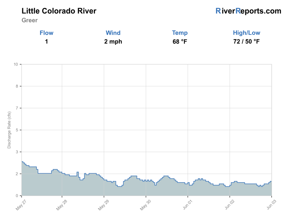
USGS data chart
Official USGS trend
Streamflow over the latest USGS reporting window.
Latest
1 cfs
Jun 3, 3 PM UTC
Weather
River weather report
Weather can change wading safety, road access, water temperature, hatches, and the best time of day to fish.
Live forecast loads as you reach this section
This keeps the report fast while still using the official National Weather Service forecast point.
Hatches and flies
Hatch chart and fly picks
Spring
Midges, blue-winged olives, small mayflies
Zebra midges, BWO dries, pheasant tails, RS2-style emergers
Early summer
Caddis, small mayflies, midges
Elk hair caddis, x-caddis, pheasant tails, hare's ears
Summer
Terrestrials, ants, beetles, grasshoppers, sporadic caddis
Foam ants, beetles, small hoppers, dry-dropper attractors
Fall
Blue-winged olives, midges, small baitfish or sculpin opportunity
BWO dries, zebra midges, soft hackles, small buggers
Cold or low water
Mostly midges and small subsurface food
Tiny midges, perdigons, micro mayflies, unweighted nymphs
Small dries
Parachute Adams, BWO, elk hair caddis, small hopper, foam ant
Use when trout are looking up in riffles, pool heads, meadow bends, or shaded banks.
Nymphs
Pheasant tail, hare's ear, zebra midge, perdigon, copper john
Use when fish hold low in pools, when mornings are cold, or when surface activity is light.
Dry-dropper rigs
Caddis or small attractor dry with a midge, pheasant tail, or tiny perdigon
Use as the default search rig on stable flows, especially when you need a light indicator that can still catch fish.
Small streamers
Mini bugger, small leech, thin sculpin, soft hackle streamer
Use in deeper pools, undercut banks, or low light when brown trout may move. Keep patterns small for the water.
Tactics
How to fish it
Walk first and cast second. On skinny meadow water, one careless step can move every fish in the pool.
Start with a dry-dropper or a single small dry in broken current. Add weight only when you need to reach a deeper pool.
Fish upstream or quartering upstream when possible so your leader reaches the fish before your shadow or fly line.
In low water, cover the best lies with one or two good casts instead of repeatedly lining the pool.
Use shade, undercut banks, pool tails, and small plunge pools as priority targets.
If you see stressed trout in warm or shallow water, stop targeting them. A helpful report is not worth harming the fishery.
Rigging
Rod, leader, and setup notes
A 7.5- to 8.5-foot 3-weight or 4-weight is comfortable for most Greer small-stream work.
A 9-foot 4-weight or 5-weight is fine if you also plan to fish nearby lakes or throw small streamers.
Use 9- to 12-foot leaders and 5X or 6X tippet in clear low water.
Keep split shot small. Heavy rigs spook fish and hang up quickly in shallow pocket water.
Carry barbless or pinch-barb hooks, especially when fishing fork reaches with single-pointed barbless-hook rules.
Access
Access and planning notes
Greer / River Reservoir corridor
Primary gauge-area planWade / float / trail
Small-stream walk-and-wade
When to pick it
Start here when the Greer gauge is stable and you can confirm legal access before entering meadow water.
Caution
Private property and small-stream fish stress matter; do not step into every open-looking bank.
Rolfe C. Hoyer Campground area
Campground-based scoutWade / float / trail
Campground walk / nearby river check
When to pick it
Use it when you are already based near Greer Lakes and want a short, rules-aware river check.
Caution
Heavy July-August rain and cold nights can change the plan fast.
Highway 261 to River Reservoir
Wild-trout corridor contextWade / float / trail
Road scout / access verification
When to pick it
Use it when your plan depends on the upper Greer wild-trout reach and you have confirmed public access.
Caution
Check current Arizona rules before assuming harvest, tackle, or season status.
East Fork Trail 95
Advanced fork checkWade / float / trail
Trail access / stream crossing
When to pick it
Pick it only when flow, weather, and seasonal rules support the immediate stream crossing and fork plan.
Caution
The trail crossing has no bridge; skip it when water, ice, or storms make the crossing unsafe.
Greer has a mix of public land, campgrounds, cabins, roads, and private property. Use marked public access and do not assume every open-looking meadow is legal access.
The Forest Service notes heavy rain is common in July and August and that nighttime temperatures can be cool or cold. Pack layers even on a warm day.
East Fork Trail 95 includes an immediate stream crossing with no bridge. Skip that plan when flows, ice, or storms make the crossing unsafe.
Small streams show impact quickly. Stay on durable paths, avoid trampling banks, and keep fish wet during release.
For food, fuel, and basic supplies, Greer is the closest trip base, but remote forest roads still deserve a full tank and offline maps.
Regulations
Check before fishing
Verify the current Arizona regulations before fishing. Arizona's special regulation table lists the Little Colorado River (Greer), upstream of River Reservoir to the confluence of the East and West Forks, as catch-and-release only for trout with no trout kept; artificial fly and lure only applies Oct. 1 through April 30, and general statewide regulations apply May 1 through Sept. 30. The East Fork and South Fork Little Colorado entries have their own seasonal closures and single-pointed barbless-hook rules, so do not treat every fork the same.
Primary town
Greer, Arizona
Best day style
Small-stream walk-and-wade plus lake backup plan
Check first
RiverReports, USGS 09383400, AZ rules, weather radar
Safety
Low flows, warm afternoons, monsoon storms, private property
Gear
Helpful gear for this water
Thermometer
Useful on small water where a warm afternoon can make trout fishing a poor choice.
Short light rod
A 3-weight or 4-weight makes tight meadow casts and small dries more enjoyable.
Barbless small-fly box
Carry midges, small mayflies, caddis, terrestrials, and pinched-barb hooks for rule-sensitive fork water.
Rain layer and offline map
Monsoon rain, cold evenings, and forest-road navigation can matter more than the fly selection.
Nearby water
Other water to research
Backup logic
Low or warm water
Stop targeting trout and compare legal lake options or other colder water after checking the current rules.
Monsoon storm
Avoid crossings, let stain clear, and use the time for road/access scouting rather than pushing small water.
Rule or boundary uncertainty
Stay on the reach you understand or choose another legal water instead of guessing around fork-specific rules.
Access issue
Move to verified public access, campground-area water, or a lake backup rather than crossing private meadow edges.
Black River
A White Mountains trout option with more remote access, forest-road, and permit planning.
Canyon Creek
A Mogollon Rim trout creek when you want a different small-stream plan with special-regulation planning.
Colorado River at Lees Ferry
A completely different Arizona trout experience: big cold tailwater, boats, clear water, and canyon logistics.
FAQ
Fast answers
Is Little Colorado River fishable today?
Little Colorado River looks very fishable right now. The live score is 91/100, based on current flow, weather, public alerts, and the report's planning context. Recheck the linked gauge and forecast before leaving because conditions can change quickly after rain, heat, access changes, or flow swings.
What flow is best for Little Colorado River?
Use the Greer gauge trend and water condition together. Stable, cool, clear flow is the best small-stream window; very low, warm, rising, or stained water should move the day to a lighter plan, a lake, or another legal water.
When should I skip Little Colorado River?
Skip or scale back when the stream is very low and warm, monsoon storms are building, special-rule or fork boundaries are unclear, East Fork crossings are unsafe, or private-property access is uncertain.
Is Little Colorado River safe to wade right now?
The fishability score is not a wading guarantee. Wade only where your chosen access has safe edges, clear footing, legal entry, and no forced crossings; high, rising, stained, or storm-affected water should be treated conservatively.
Is the Little Colorado River near Greer good for fly fishing?
Yes, but it is a small, condition-sensitive trout stream. It is best when flows are stable, water is cold, and you use careful small-stream tactics instead of big-river methods.
What gauge should I check?
Use RiverReports for the quick Greer chart and USGS 09383400, Little Colorado River at Greer, for the official streamflow and gage-height data.
Can I keep trout?
Check the current Arizona rules before fishing. The special regulation table lists the Greer reach above River Reservoir to the East and West Fork confluence as catch-and-release only for trout.
What flies should I bring?
Bring small dries, caddis, blue-winged olives, terrestrials, zebra midges, pheasant tails, hare's ears, small perdigons, soft hackles, and a few mini streamers.
Sources
Source set for this report
Reviewed 2026-05-31