Arizona / Southwest
Black River
A practical White Mountains report for the East Fork, West Fork, and mainstem Black River, with flow context, trout tactics, remote access notes, permits, weather, and source links.
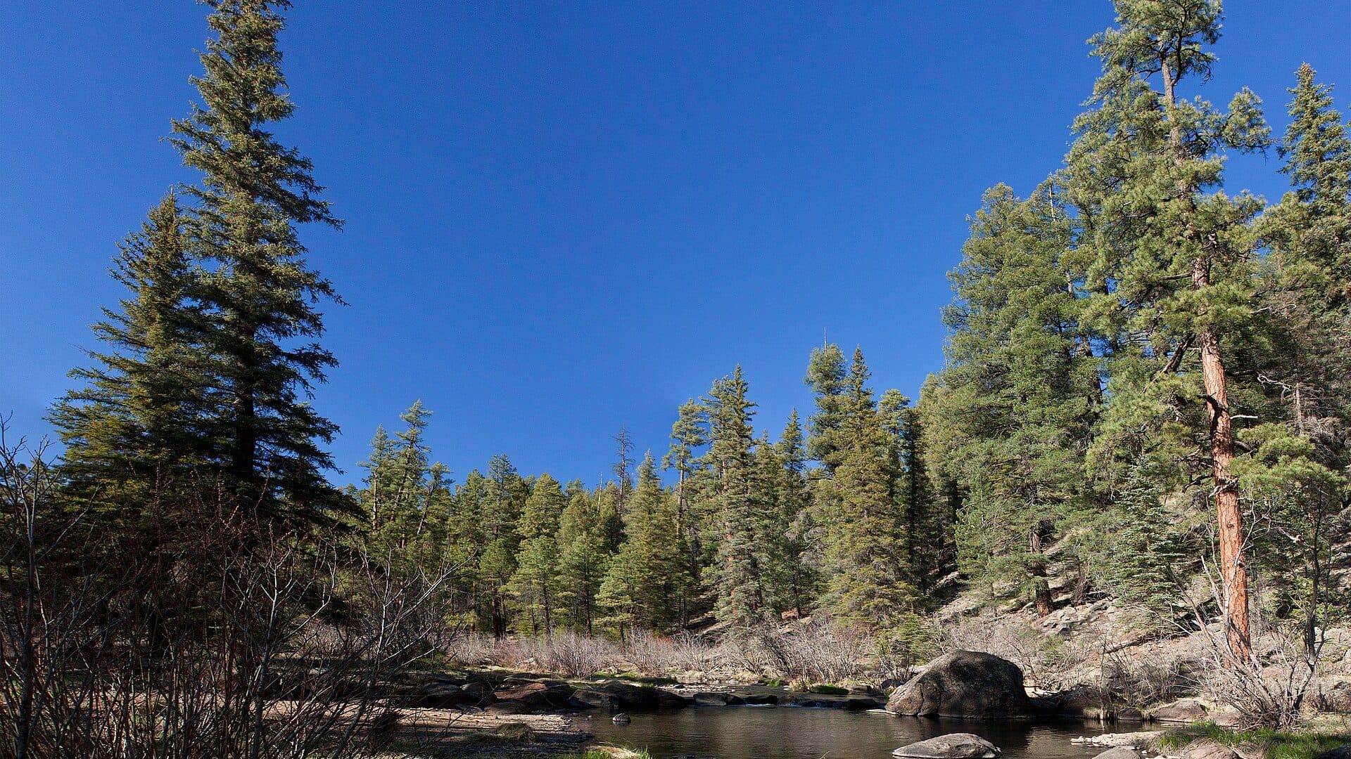
Image: Black River East Fork in the White Mountains (5849786784) / CC BY-SA 2.0 / Alan Stark from Goodyear, AZ, United StatesFishability now: Black River fishability today
GreatData confidence: High91/100
Fishable now because Apache gauge is stable, weather is usable, and no public alert is active.
Flow observed
3:30 PM UTC
Weather observed
4:00 PM UTC
Score calculated
4:19 PM UTC
Why this rating
Flow
Weather
Public alerts
Next 6-12 hours
Hold
Stable live data supports staying with the plan, but recheck the gauge and forecast before leaving.
USGS flow
26 cfs
Current trend: flow stable, so weather, temperature, and access checks drive the next change.
More planning details: flies, flow bands, and live source checks
Fish it today
Start here
Pick the reach first. Use Aspen/East Fork for an upper fork plan, Buffalo Crossing or Bear Creek for trail-linked mainstem checks, and only continue toward Wildcat or reservation-boundary water when access and permits are clear.
Best flow clue
Use the RiverReports/USGS trend more than a single number. Stable or slowly falling clear water is the best trout window; rising monsoon water, muddy color, or road uncertainty should make the plan conservative.
Skip trigger
Skip or scale back when thunderstorms are building, forest roads are muddy, fire or access alerts are active, reservation or permit boundaries are uncertain, water is warm enough to stress trout, or the graph is rising fast.
Flow decision bands
Low and clear
Fishable when water stays cold, but expect spooky trout, smaller dries or droppers, and slow approaches in shade and broken pockets.
Best fork/mainstem window
Stable or slowly falling clear flow is the best signal for dry-droppers, pocket nymphs, and small streamers through deeper bends.
Monsoon or unsafe
Rising water, lightning, debris, or muddy road risk should move the plan to scouting, a safer backup, or another day.
Likely stained after storms
Short local storms can change canyon clarity and access quickly; check the graph, sky, road surface, and water color together.
USGS flow
26 cfs
Current trend: flow stable, so weather, temperature, and access checks drive the next change.
Live USGS flow
26 cfs / stable
Live NWS forecast
73F / Sunny
Water temperature not verified
Heat guidance uses weather and river type unless an official water-temperature value is available.
No NWS alert flag
No active NWS alert was returned for this forecast point.
Use the RiverReports chart and USGS 09490500 near Fort Apache before choosing a wading or hiking plan.
Check Apache-Sitgreaves alerts, fire restrictions, road conditions, and storm risk before driving forest roads.
Confirm Arizona regulations and tribal permit requirements before fishing near or beyond reservation boundaries.
Expect small-stream trout tactics in the forks and more remote canyon-style fishing downstream.
Editorial review
How this report is maintained
This report is maintained from official flow, weather, Forest Service, Arizona regulation, and tribal-access planning sources, then translated into a conservative same-day trout decision.
Byline
BlueStreamFly editorial desk
Reviewed by
BlueStreamFly source review
Maintained by
BlueStreamFly
Last material review
2026-05-31
Report confidence
High confidence
82/100
Strong flow, forest-access, regulation, weather, and tribal-permit source coverage supports the Black River fishability guidance. Confidence is capped by remote-road, monsoon, fire, and boundary conditions that still require a same-day check.
Regulations
Arizona fishing regulations and tribal permit sources give the rule-check path for fork and boundary-sensitive plans.
Flow support
RiverReports visual flow support is backed by USGS 09490500 near Fort Apache.
Access support
Apache-Sitgreaves trail and campground pages support the core access landmarks and remote-road framing.
Weather and safety
NWS forecast support is paired with monsoon, road, fire, heat, and remote-travel skip triggers.
Angler usefulness
The page separates fork selection, trail access, boundary checks, pressure strategy, and backup-water decisions.
Editorial review
A public correction path, source standards page, latest verified note, and change log are included.
Fishability source review
2026-05-31 / material content or source review
RiverReports and USGS flow support, Apache-Sitgreaves access references, Arizona fishing rules, tribal permit sources, and the National Weather Service forecast point were rechecked before adding the current fishability decision layer.
2026-05-31
Upgraded the page to the Pine Creek fishability standard with a reviewed route profile, flow decision bands, access cards, backup logic, source-confidence meter, and a top-page current-fishability answer.
2026-05-24
Initial source-reviewed report published with flows, weather, hatches, flies, tactics, access, regulations, and FAQs.
Angler planning edge
Local details that change the plan
Best for
High-country trout anglers willing to match the fork, mainstem, and road plan to current conditions, Dry-dropper, small nymph, and pocket-water fishing when the graph is stable and the water is clear, Remote walk-and-wade days where access, permits, and weather are checked before fly choice, Anglers who can pivot quickly when monsoon storms, muddy roads, or reservation-boundary questions appear
Wade or float
Treat the Black River as a walk-and-wade and trail-access report. The forks and mainstem planning corridors are not a casual float plan, and road, trail, and boundary decisions matter before wading.
Best flows
Use the RiverReports/USGS trend more than a single number. Stable or slowly falling clear water is the best trout window; rising monsoon water, muddy color, or road uncertainty should make the plan conservative.
When to skip
Skip or scale back when thunderstorms are building, forest roads are muddy, fire or access alerts are active, reservation or permit boundaries are uncertain, water is warm enough to stress trout, or the graph is rising fast.
Local plan
Pick the reach first. Use Aspen/East Fork for an upper fork plan, Buffalo Crossing or Bear Creek for trail-linked mainstem checks, and only continue toward Wildcat or reservation-boundary water when access and permits are clear.
Pressure
Obvious campground and crossing access concentrates anglers. Walking legally away from the easiest pullouts usually matters more than changing flies repeatedly.
Access nuance
National forest access, tribal boundaries, non-motorized trail sections, fire hazards, and storm-damaged roads all affect fishability. Treat the map, permit, and alert check as part of the fishing report.
Backup water
If the Black River is high, muddy, hot, or permit-limited, compare Canyon Creek, the Little Colorado, or Silver Creek only after checking their current rules, access, and road conditions.
About the river
Setting, character, and why it fishes the way it does.
The Black River forms in the White Mountains of eastern Arizona from the East Fork and West Fork, then drops into a more remote mainstem corridor before eventually joining the White River to form the Salt River.
The Forest Service describes the Black River Mainstream Trail as covering the East Fork below Buffalo Crossing and the mainstem from the confluence of the east and west forks to the reservation boundary. That makes Buffalo Crossing, Bear Creek, Wildcat Bridge, and the reservation boundary key planning references.
This page is written for anglers using legal public access on the Apache-Sitgreaves National Forests and for anglers who are separately researching tribal permits. Do not assume one license or access rule covers every reach.
Target species
Apache trout
A native-trout planning target in parts of the White Mountains system. Confirm current AZGFD and tribal rules before targeting or handling native trout.
Brown trout
A common fly-fishing target in deeper pools, undercut banks, and lower-light holding water.
Rainbow trout
Present in stocked and managed opportunities. Check current stocking and regulations before assuming recent plants.
Smallmouth bass and warmwater species
More relevant in warmer lower water than in every high-country trout reach.
Reading the water
Low and clear
Use long leaders, smaller dries and nymphs, and careful approaches. Fish shade, undercut banks, and broken riffle texture.
Stable medium flow
The most flexible window for dry-dropper rigs, pocket-water nymphing, and small streamers through deeper bends.
Monsoon rise
Leave crossings alone and watch the road home. Fast local rain can move water, debris, and mud through canyon sections.
Warm afternoons
Carry a thermometer and avoid stressing trout when water temperatures climb. Fish early, shift to shaded water, or stop.
Best seasons
Spring
Flows can rise with snowmelt and storms. Fish when the graph is stable or dropping and forest access is open.
Early summer
Often a strong trout window before heat and monsoon storms complicate afternoon plans.
Monsoon season
Fishing can be good between storms, but lightning, muddy roads, and flashier runoff are real planning constraints.
Fall
Clear water and cooler weather can make careful dry-fly, nymph, and streamer fishing productive.
Winter
A limited, weather-dependent period with cold water, snow, ice, and road access concerns.
Preferred flow source
Black River at Apache
RiverReports is the preferred chart source when coverage exists. When a matching USGS gauge exists, keep it open as the official backstop for station data and current hydrograph context.
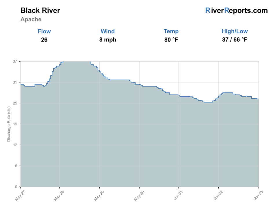
USGS data chart
Official USGS trend
Streamflow over the latest USGS reporting window.
Latest
26 cfs
Jun 3, 4 PM UTC
Weather
River weather report
Weather can change wading safety, road access, water temperature, hatches, and the best time of day to fish.
Live forecast loads as you reach this section
This keeps the report fast while still using the official National Weather Service forecast point.
Hatches and flies
Hatch chart and fly picks
Spring
Blue-winged olives, midges, early caddis
BWO dries, zebra midges, pheasant tails, soft hackles
Late spring to early summer
Caddis, small mayflies, stonefly activity
Elk hair caddis, stimulators, hare's ears, prince nymphs
Summer
Terrestrials, caddis, attractor dry windows
Ants, beetles, small hoppers, parachute Adams, dry-droppers
Fall
Blue-winged olives, midges, sparse caddis
Small BWO dries, RS2-style emergers, zebra midges, soft hackles
High or stained water
Limited surface focus
Small buggers, leeches, dark streamers, bead-head nymphs
Small dries
Parachute Adams, BWO, elk hair caddis, ant, beetle, small hopper
Use in low clear water, shaded pockets, riffles, and summer terrestrial windows.
Nymphs
Pheasant tail, hare's ear, prince nymph, perdigon, zebra midge
Use through pockets, deeper bends, and cold mornings before fish commit to the surface.
Attractor dry-droppers
Stimulator or chubby dry with a small tungsten dropper
Use for covering broken water on the forks without overcomplicating the rig.
Small streamers
Woolly bugger, leech, small sculpin, olive or black streamer
Use near undercut banks, deeper pools, and slightly stained water.
Tactics
How to fish it
Pick the reach before choosing flies. The East Fork, West Fork, and mainstem do not all fish or access the same way.
Fish upstream with short casts in the forks. A few clean drifts in each pocket beat repeated false casts over small water.
In the mainstem corridor, cover deeper bends, boulder shade, and undercut banks with nymphs or small streamers.
After monsoon rain, check the road as seriously as the river. Getting out can be harder than getting in.
Keep native-trout handling fast and wet. Photograph only when the fish can stay close to the water.
Give other anglers room at obvious access points; the best value of this river is often found by walking.
Rigging
Rod, leader, and setup notes
A 9-foot 4-weight is a practical all-around rod for dries, dry-droppers, and light nymphing.
A shorter 3-weight can be useful in tighter fork water when brush and short casts dominate.
Use 4X to 6X tippet depending on clarity, fly size, and fish pressure.
Keep streamer rigs small and controlled; this is often pocket and pool fishing, not big-river stripping.
Wear traction and carry a wading staff for slick rocks, canyon access, and remote crossings.
Access
Access and planning notes
Aspen / East Fork Black River
Upper fork startWade / float / trail
Campground access / walk-and-wade
When to pick it
Start here when you want a high-country fork plan with a simpler first visual check near Alpine.
Caution
Do not assume upper access removes native-trout rules, warm-water stress, or forest-road hazards.
Buffalo Crossing
Mainstream Trail startWade / float / trail
Trail-linked walk-and-wade
When to pick it
Use it when the trail, road, and flow all support a longer mainstem fishing plan.
Caution
Remote access means storms, road issues, and return timing deserve as much attention as fly choice.
Bear Creek / trail corridor
Walk-away pressure reliefWade / float / trail
Non-motorized trail access
When to pick it
Pick this when obvious crossings are busy and you have time to hike legally to quieter water.
Caution
Bring offline maps and avoid committing below safe exit points when storms are possible.
Wildcat / reservation boundary
Advanced boundary checkWade / float / trail
Road scout / permit planning
When to pick it
Use only when you have confirmed roads, forest access, tribal boundaries, and any required permits.
Caution
National forest and reservation waters are not the same access plan; confirm before crossing boundaries.
Use official Forest Service roads, signed trailheads, and current Apache-Sitgreaves alerts. Fire restrictions and closures can change the plan.
The Forest Service warns that Wallow Fire-affected areas can have falling trees, flooding, burned-out stump holes, and storm-related hazards.
Some Black River routes are remote, rough, or non-motorized. Do not assume a passenger car can reach every fishing plan.
Reservation waters require the correct tribal permits and rules. Research White Mountain Apache Tribe and San Carlos Apache Tribe requirements before crossing boundaries.
Regulations
Check before fishing
Check the current Arizona Game and Fish regulations before fishing, especially special regulations for the West Fork Black River and rules for native trout. If your plan touches White Mountain Apache or San Carlos Apache reservation waters, confirm tribal fishing, habitat, and special-use permits separately.
Primary towns
Alpine, Springerville, Eagar
Best day style
Small-stream walk-and-wade, remote trail access
Check first
Flow, monsoon forecast, fire restrictions, permits
Safety
Remote roads, storms, bears, reservation boundaries
Gear
Helpful gear for this water
High-clearance vehicle plan
Not every reach needs one, but rough forest roads and storm damage can make access the limiting factor.
Thermometer
Useful during warm periods so trout handling decisions are based on actual water temperature.
Compact dry-dropper box
Small dries and tungsten droppers cover much of the fork and pocket-water fishing.
Offline map and satellite backup
Cell coverage can be unreliable around remote White Mountains canyons and forest roads.
Nearby water
Other water to research
Backup logic
High or rising water
Skip crossings and compare Canyon Creek, Little Colorado, or Silver Creek only after checking their flow, rules, and roads.
Monsoon or road risk
Leave extra exit time, avoid low road crossings, and treat muddy roads as a hard reason to simplify or skip.
Permit or boundary uncertainty
Stay on verified public national-forest access or choose a different legal water rather than guessing at tribal boundaries.
Heat
Fish early, carry a thermometer, and stop trout fishing when water temperatures become stressful.
Canyon Creek
Another Arizona trout stream to compare when Black River roads, storms, or permits complicate the plan.
Little Colorado River
A White Mountains planning alternative with its own access and regulation checks.
Silver Creek
A managed Arizona trout water where special regulations matter. Research separately before fishing.
FAQ
Fast answers
Is Black River fishable today?
Black River looks very fishable right now. The live score is 91/100, based on current flow, weather, public alerts, and the report's planning context. Recheck the linked gauge and forecast before leaving because conditions can change quickly after rain, heat, access changes, or flow swings.
What flow is best for Black River?
Use the RiverReports/USGS trend more than a single number. Stable or slowly falling clear water is the best trout window; rising monsoon water, muddy color, or road uncertainty should make the plan conservative.
When should I skip Black River?
Skip or scale back when thunderstorms are building, forest roads are muddy, fire or access alerts are active, reservation or permit boundaries are uncertain, water is warm enough to stress trout, or the graph is rising fast.
Is Black River safe to wade right now?
The fishability score is not a wading guarantee. Wade only where your chosen access has safe edges, clear footing, legal entry, and no forced crossings; high, rising, stained, or storm-affected water should be treated conservatively.
Is the Black River in Arizona good for fly fishing?
Yes. It is one of Arizona's important high-country stream systems, with fork water, mainstem canyon water, trout opportunity, and remote access. The best plan depends on flow, roads, permits, and current regulations.
What gauge should I check?
Use USGS 09490500, Black River near Fort Apache, as the official flow fallback. RiverReports also has a Black River at Apache page and chart for quick visual checks.
Do I need a tribal permit?
Possibly. Public national-forest reaches and reservation waters are not the same thing. If your route enters White Mountain Apache or San Carlos Apache lands, confirm the current tribal permit and access rules before fishing.
What flies should I bring?
Carry small caddis and mayfly dries, ants, beetles, small hoppers, pheasant tails, hare's ears, zebra midges, dry-dropper attractors, and a few small streamers.
Sources
Source set for this report
Reviewed 2026-05-31