Arizona / Southwest
Colorado River
A Lees Ferry tailwater report for the Colorado River below Glen Canyon Dam, with RiverReports flow context, USGS water data, trout tactics, access notes, regulations, weather, and source links.
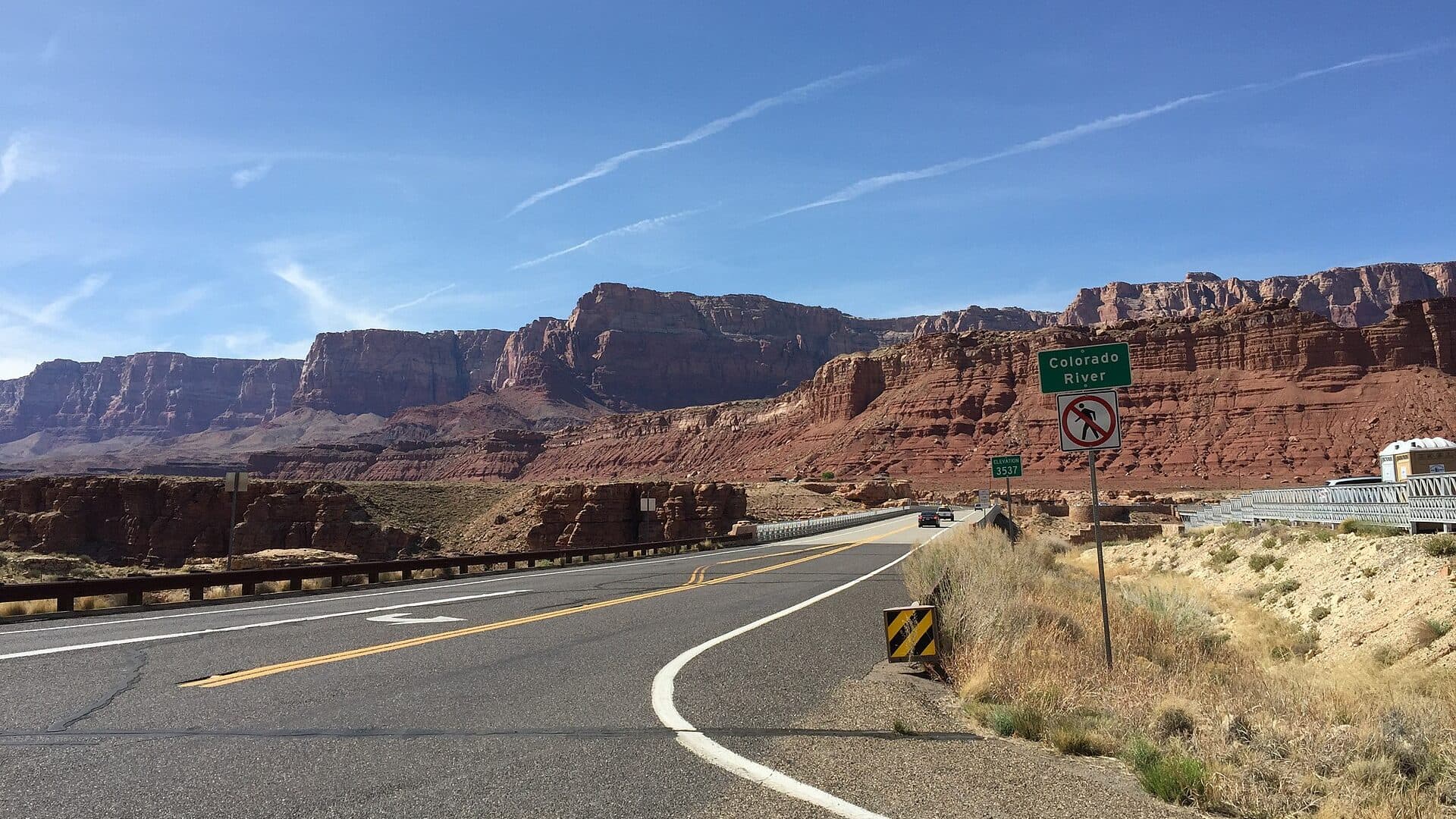
Image: 2016-03-20 14 30 16 View north along U.S. Route 89A just south of the Colorado River at the south end of the new Navajo Bridge in Marble Canyon, Arizona / CC BY-SA 4.0 / FamartinFishability now: Colorado River fishability today
GreatData confidence: High96/100
Fishable now because Lees Ferry gauge is stable, weather is usable, and no public alert is active.
Flow observed
4:00 PM UTC
Weather observed
4:00 PM UTC
Score calculated
4:51 PM UTC
Why this rating
Flow
Water temperature
Public alerts
Next 6-12 hours
Hold
Stable live data supports staying with the plan, but recheck the gauge and forecast before leaving.
USGS flow
7,570 cfs
Current trend: flow stable, so weather, temperature, and access checks drive the next change.
More planning details: flies, flow bands, and live source checks
Fish it today
Start here
Decide walk-in versus boat first. Walk-in anglers should start with legal bank access near Lees Ferry; boat anglers should verify permit, ramp, PFD, wind, and release timing before choosing fly weight or drift length.
Best flow clue
Use the Lees Ferry release trend and water temperature together. Stable releases are the easiest planning window; rising or changing releases should move anglers off low bars and toward safer edges, boat control, or a later check.
Skip trigger
Skip or scale back when releases are changing faster than your access plan can handle, canyon wind is unsafe for your craft, heat and sun exposure are extreme, the backcountry permit or boating setup is not squared away, or rule boundaries are unclear.
Flow decision bands
Low or steady release
Fishable and technical; use long leaders, small midges or scuds, careful wading, and low profiles in clear water.
Best tailwater window
Stable releases with manageable wind give the best mix of walk-in edges, controlled boat drifts, and predictable trout lies.
Changing release
Move off low bars, watch rising edges, and adjust weight, drift length, and boat position before the water traps your plan.
Wind, heat, or permit hold
A good gauge can still be a poor day if canyon wind, desert heat, boat logistics, or permit requirements are not handled.
USGS flow
7,570 cfs
Current trend: flow stable, so weather, temperature, and access checks drive the next change.
Live USGS flow
7,570 cfs / stable
Live NWS forecast
83F / Sunny
Live water temperature
56F from USGS
No NWS alert flag
No active NWS alert was returned for this forecast point.
Use RiverReports and USGS 09380000 before choosing a wade, boat, or backhaul plan.
Check both discharge and water temperature; the USGS station reports streamflow, gage height, and water temperature.
NPS lists artificial fly and lure rules, barbless hooks, and a 2-rainbow-trout limit from Glen Canyon Dam to the beginning of Paria Riffle.
Watercraft users between Glen Canyon Dam and Lees Ferry need the Lees Ferry Backcountry Permit; bank-only anglers do not need that permit.
Editorial review
How this report is maintained
This report is maintained from official flow, temperature, weather, NPS access, and Arizona/NPS regulation sources, then translated into clear Lees Ferry fishability guidance.
Byline
BlueStreamFly editorial desk
Reviewed by
BlueStreamFly source review
Maintained by
BlueStreamFly
Last material review
2026-05-31
Report confidence
High confidence
86/100
Strong NPS regulation and access sources, USGS/RiverReports flow support, water-temperature context, and weather coverage support the Lees Ferry fishability guidance. Confidence is capped by dam-release timing, wind, boating logistics, and heat exposure that still need a same-day check.
Regulations
NPS and Arizona sources document artificial-fly/lure, barbless-hook, limit, closure, and reach-boundary guidance.
Flow support
RiverReports coverage is backed by USGS 09380000 at Lees Ferry, including streamflow and temperature context.
Access support
NPS Lees Ferry information supports launch, bank, permit, and corridor access decisions.
Weather and safety
NWS support is paired with cold-water, dam-release, canyon-wind, desert-heat, PFD, and closure-buoy cautions.
Angler usefulness
The page separates walk-in, boat, backhaul, release, permit, and backup-water decisions.
Editorial review
A public correction path, source standards page, latest verified note, and change log are included.
Fishability source review
2026-05-31 / material content or source review
RiverReports and USGS Lees Ferry flow support, NPS fishing regulations, Lees Ferry access and backcountry-permit guidance, Arizona rule references, and the National Weather Service forecast point were rechecked before adding the current fishability decision layer.
2026-05-31
Upgraded the page to the Pine Creek fishability standard with a reviewed route profile, dam-release decision bands, access cards, backup logic, source-confidence meter, and a top-page current-fishability answer.
2026-05-24
Initial source-reviewed report published with flows, weather, hatches, flies, tactics, access, regulations, and FAQs.
Angler planning edge
Local details that change the plan
Best for
Lees Ferry trout anglers deciding between walk-in, boat, and backhaul plans, Clear-water tailwater nymphing, midges, scuds, worms, and precise long-drift presentations, Trips where dam-release flow, water temperature, wind, and special rules shape the day, Anglers who can treat permits, cold water, sun, and changing releases as part of the fishing plan
Wade or float
Use the route as both a walk-in and boat-planning page. Bank anglers can fish reachable water near Lees Ferry, while boat and backhaul users need the right permit, safety setup, and release-aware plan.
Best flows
Use the Lees Ferry release trend and water temperature together. Stable releases are the easiest planning window; rising or changing releases should move anglers off low bars and toward safer edges, boat control, or a later check.
When to skip
Skip or scale back when releases are changing faster than your access plan can handle, canyon wind is unsafe for your craft, heat and sun exposure are extreme, the backcountry permit or boating setup is not squared away, or rule boundaries are unclear.
Local plan
Decide walk-in versus boat first. Walk-in anglers should start with legal bank access near Lees Ferry; boat anglers should verify permit, ramp, PFD, wind, and release timing before choosing fly weight or drift length.
Pressure
Lees Ferry is a destination fishery. Boat traffic, obvious walk-in runs, and guide pressure can matter, so fish clean drifts, avoid crowding, and use off-angle shelves instead of forcing the most visible water.
Access nuance
Cold water, desert heat, limited shade, dam-release movement, ramp etiquette, closure buoys, and backcountry permits all affect fishability even when trout conditions look good.
Backup water
If Lees Ferry is poor because of wind, releases, permits, or heat, compare smaller Arizona trout waters such as Canyon Creek, Black River, or the Little Colorado only after checking their current rules and access.
About the river
Setting, character, and why it fishes the way it does.
This report covers the Colorado River tailwater at Lees Ferry, below Glen Canyon Dam in Glen Canyon National Recreation Area. The dam changed this reach from a warm, silty desert river into a cold, clear trout fishery.
NPS describes the Glen Canyon Dam to Lees Ferry reach as different from Lake Powell, with cold clear water that makes it a world-class trout fishery. That same clarity means fish can be selective, especially during calm bright conditions.
Lees Ferry is also a historic travel corridor and one of the most important practical reference points in the canyon. For anglers, USGS 09380000 is the day-to-day source for streamflow, gage height, and water temperature.
Target species
Rainbow trout
The primary fly-fishing target at Lees Ferry. NPS lists a 2-rainbow-trout daily limit from Glen Canyon Dam to the beginning of Paria Riffle.
Other sport fish
NPS lists other sport fish categories in Colorado River regulations, but this report is written for the trout-focused Lees Ferry tailwater plan.
Protected native fish
NPS lists bonytail, Colorado pikeminnow, humpback chub, and razorback sucker as prohibited to possess. Release protected native fish immediately if encountered.
Reading the water
Low or steady release
Wade and walk-in options can be easier, but clear water demands longer leaders, smaller flies, and careful angles.
Rising dam release
Move with the water, stay off low bars that may flood, and fish fresh edge water rather than standing in changing current.
Higher release
Boat or backhaul logistics become more important. Fish protected banks, softer seams, and shelves instead of forcing unsafe wades.
Cold clear water
Use small midges, scuds, and slim nymphs with clean drifts. Sight-fishing and long drifts often matter more than changing flies every cast.
Best seasons
Winter
Cold mornings and steady tailwater temperatures make midge and nymph fishing the main plan. Dress for wind and shade inside the canyon.
Spring
A strong trout window when air temperatures are comfortable and small subsurface patterns remain reliable.
Summer
The river stays cold, but desert heat, sun exposure, and afternoon wind make early starts, water, and shade important.
Fall
Often a comfortable season for mixed walk-in and boat plans, with midges, scuds, worms, and small streamers all worth carrying.
Preferred flow source
Colorado River at Lees Ferry
RiverReports is the preferred chart source when coverage exists. When a matching USGS gauge exists, keep it open as the official backstop for station data and current hydrograph context.
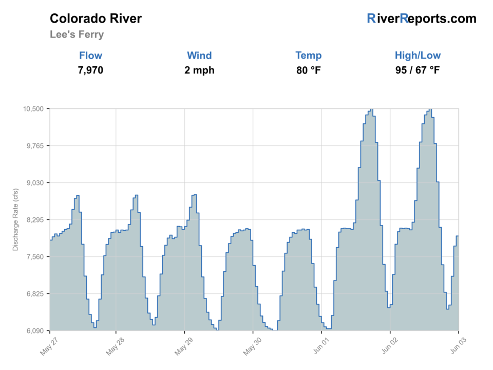
USGS data chart
Official USGS trend
Streamflow over the latest USGS reporting window.
Latest
7,570 cfs
Jun 3, 4 PM UTC
Weather
River weather report
Weather can change wading safety, road access, water temperature, hatches, and the best time of day to fish.
Live forecast loads as you reach this section
This keeps the report fast while still using the official National Weather Service forecast point.
Hatches and flies
Hatch chart and fly picks
Year-round
Midges and tiny aquatic insects
Zebra midges, thread midges, RS2-style emergers, tiny soft hackles
Spring
Midges, small mayflies, scuds, aquatic worms
Midge pupa, small pheasant tails, scuds, San Juan worms
Summer
Midges, scuds, occasional attractor windows near structure
Small midges, scuds, terrestrials near banks, light nymph rigs
Fall
Midges, scuds, baitfish or streamer opportunity
Midges, scuds, leeches, small streamers, soft hackles
High or changing release
Limited surface focus
San Juan worms, scuds, heavier nymph rigs, small streamers
Midges
Zebra midge, thread midge, RS2-style emerger, Griffith's gnat
Use during clear water, calm periods, and trout feeding in slower shelves or soft seams.
Tailwater nymphs
Scuds, pheasant tails, perdigons, small sowbug-style patterns
Use for long clean drifts from the boat or while working seams from shore.
Worms and eggs
San Juan worm, micro worm, small egg patterns
Use when releases move food, the water is slightly off-color, or fish are holding close to the bottom.
Small streamers
Leech, mini bugger, small baitfish, soft hackle streamer
Use along shelves, banks, and low-light structure when fish are willing to chase.
Tactics
How to fish it
Decide first whether the day is a walk-in day, a boat day, or a backhaul day. The reachable water changes the whole report.
For walk-in fishing, start near legal bank access and fish slowly. Clear water rewards long drifts and low profiles.
From a boat, use controlled drifts through shelves, seams, and bank structure instead of racing to every visible trout.
Watch water level changes around bars and shoreline shelves. A safe spot at one release can become unsafe later.
Carry both tiny technical flies and simple food patterns. Lees Ferry fish can be selective, but current changes often make worms and scuds practical.
Do not fish the posted closure immediately below Glen Canyon Dam.
Rigging
Rod, leader, and setup notes
A 9-foot 5-weight is the most practical all-around rod for nymphs, dries, and small streamers.
Use 9- to 12-foot leaders and 5X or 6X tippet when the river is clear and fish are selective.
For nymphing from a boat or deeper bank water, carry enough weight to touch bottom without dragging every drift.
Pinch or use barbless hooks before fishing; NPS lists barbless hooks only for the dam-to-Paria Riffle reach.
Bring sun protection, cold-water layers, and a PFD if you are using any craft.
Access
Access and planning notes
Lees Ferry launch ramp
Boat and backhaul stagingWade / float / trail
Ramp / watercraft access
When to pick it
Use it when your plan involves upriver boat water, backhaul logistics, or controlled drifts beyond the walk-in reach.
Caution
Confirm permit, PFD, ramp etiquette, motor restrictions, wind, and release timing before launching.
Walk-in bank water
No-boat trout planWade / float / trail
Bank / walk-and-wade
When to pick it
Pick it when releases are stable and you want a simpler legal bank plan without watercraft logistics.
Caution
Clear water, cold current, and changing releases still make wading conservative.
Dam-to-Lees Ferry corridor
Permit-aware upriver planWade / float / trail
Boat / backcountry permit
When to pick it
Use it only when the permit, craft, weather, and return logistics are all in place.
Caution
The area immediately below the dam is closed where posted; know the buoys and boundaries.
Paria Riffle / Navajo Bridge context
Rule-boundary checkWade / float / trail
Boundary planning / road scout
When to pick it
Use it when your day may extend beyond the core Lees Ferry trout-rule reach.
Caution
Rules change by reach, so do not treat every Colorado River mile as the same regulation plan.
Lees Ferry is reached from Page by US 89 and US 89A, then a paved road into the ferry area.
Do not block the launch ramp. NPS notes a 30-minute length-of-time restriction at public access courtesy docks and ramps.
The river is cold and clear even when desert air is hot. Wading and boating plans should account for cold-water exposure.
If using a boat, check NPS vessel restrictions, horsepower rules at high releases, PFD rules, and the backcountry permit requirement.
Summer heat, canyon wind, and limited shade can be more dangerous than the fishing looks from the parking lot.
Regulations
Check before fishing
Verify current NPS and Arizona regulations before fishing. NPS lists the Glen Canyon Dam to beginning of Paria Riffle reach as artificial fly and lure only, barbless hooks only, and a 2-rainbow-trout daily limit. Rainbow trout taken from this portion must be killed and retained as part of the bag limit or immediately released. The area immediately below Glen Canyon Dam, posted with buoys, is closed to entry.
Primary towns
Page, Marble Canyon, Lees Ferry
Best day style
Tailwater walk-and-wade, drift boat, or backhaul
Check first
RiverReports, USGS flow and temperature, NPS rules, wind
Safety
Cold water, dam releases, sun, wind, boat permits, closure buoys
Gear
Helpful gear for this water
Water thermometer
USGS reports water temperature, but a thermometer helps confirm bank or side-channel conditions where you fish.
Fine tippet and small fly box
Clear water and small food call for 5X, 6X, midges, scuds, and slim nymphs.
Sun and wind kit
Hat, sun gloves, sunscreen, layers, and extra water matter on a desert tailwater day.
Boat safety setup
If boating, use the required permit, PFD, river map, anchor discipline, and a plan for changing releases.
Nearby water
Other water to research
Backup logic
Changing release
Move to safer bank edges, shorten the plan, or wait for a more stable release window instead of standing on low bars.
Wind or boating issue
Keep the day to walk-in bank water, hire/confirm a safe backhaul, or choose another water if your craft setup is not right.
Heat or sun exposure
Start early, carry extra water and shade, and stop before desert exposure becomes the real risk.
Permit or rule issue
Stay bank-only where permits are not required or choose a different legal water rather than guessing on backcountry, closure, or reach rules.
Little Colorado River
A separate Arizona river report to compare for White Mountains and eastern Arizona planning.
Canyon Creek
A smaller Mogollon Rim trout creek when you want a walk-and-wade stream plan instead of a big tailwater.
Black River
A White Mountains option with more remote road, permit, and forest-access planning.
FAQ
Fast answers
Is Colorado River fishable today?
Colorado River looks very fishable right now. The live score is 96/100, based on current flow, weather, public alerts, and the report's planning context. Recheck the linked gauge and forecast before leaving because conditions can change quickly after rain, heat, access changes, or flow swings.
What flow is best for Colorado River?
Use the Lees Ferry release trend and water temperature together. Stable releases are the easiest planning window; rising or changing releases should move anglers off low bars and toward safer edges, boat control, or a later check.
When should I skip Colorado River?
Skip or scale back when releases are changing faster than your access plan can handle, canyon wind is unsafe for your craft, heat and sun exposure are extreme, the backcountry permit or boating setup is not squared away, or rule boundaries are unclear.
Is Colorado River safe to wade right now?
The fishability score is not a wading guarantee. Wade only where your chosen access has safe edges, clear footing, legal entry, and no forced crossings; high, rising, stained, or storm-affected water should be treated conservatively.
Is the Colorado River at Lees Ferry good for fly fishing?
Yes. NPS describes the cold clear water between Glen Canyon Dam and Lees Ferry as a world-class trout fishery. It is a technical tailwater, so flows, clarity, regulations, and access style matter.
What gauge should I check?
Use RiverReports for a quick chart and USGS 09380000, Colorado River at Lees Ferry, for official streamflow, gage height, and water temperature.
Do I need a permit?
Bank-only hiking and fishing do not require the Lees Ferry Backcountry Permit according to NPS. Visitors using any watercraft between Glen Canyon Dam and Lees Ferry do need the permit.
What flies should I bring?
Bring tiny midges, scuds, pheasant tails, slim nymphs, San Juan worms, small eggs, soft hackles, and a few small streamers.
Sources
Source set for this report
Reviewed 2026-05-31