Wyoming / West
Shoshone River
A Cody-area Shoshone report focused on the mainstem below Buffalo Bill Reservoir, public access, dam-influenced flow, and practical trout tactics.
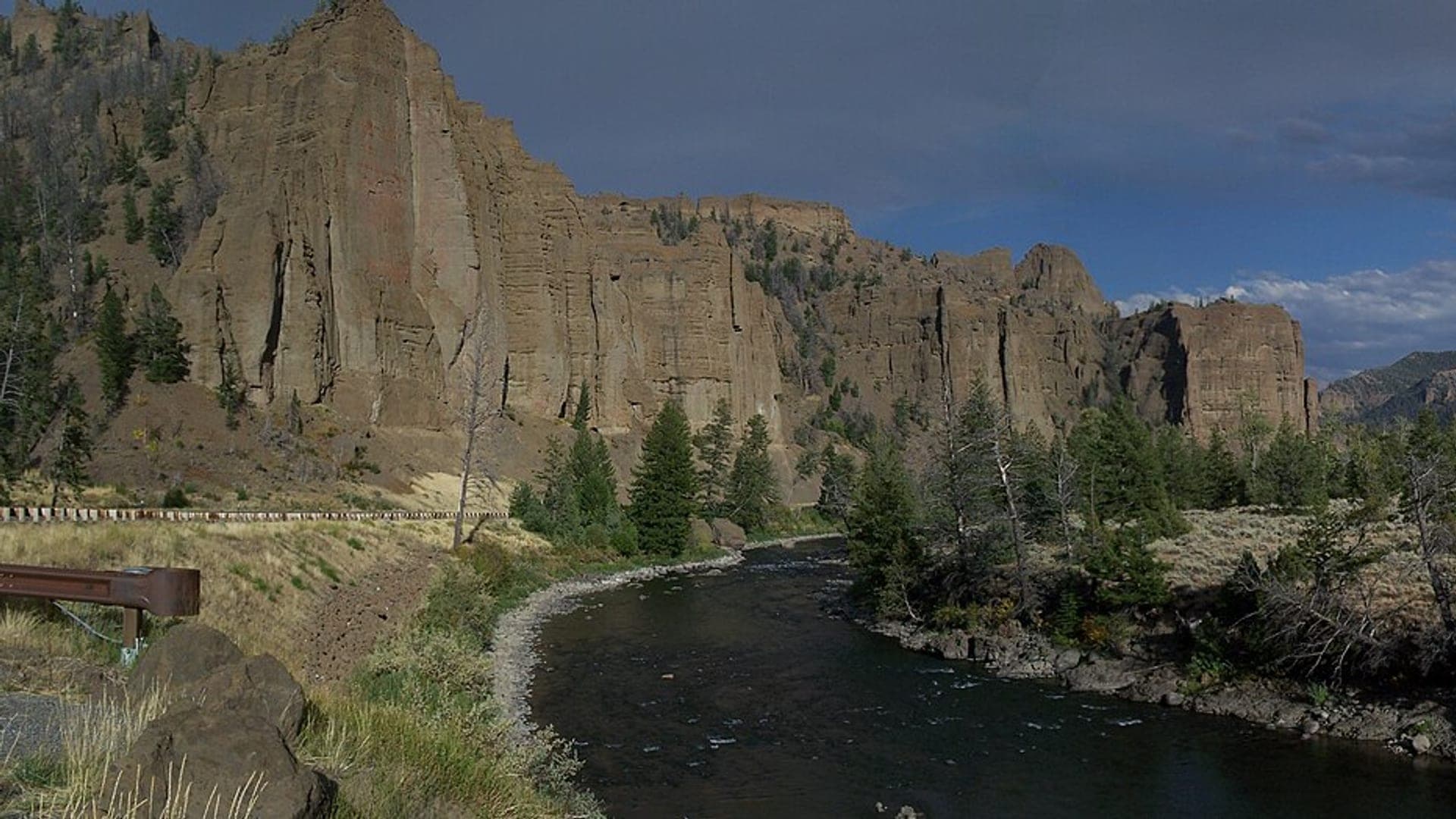
Image: Panoramic view of the Shoshone River, between Cody, WY and East Entrance of Yellowstone / CC BY-SA 3.0 / Betty Jo TindleFishability now: Shoshone River fishability today
GreatData confidence: High96/100
Fishable now because the live gauge is falling, weather is mild, and no public alert is active.
Flow observed
4:00 PM UTC
Weather observed
5:00 PM UTC
Score calculated
5:24 PM UTC
Why this rating
Flow
Water temperature
Public alerts
Next 6-12 hours
Improving / hold
A falling gauge and usable weather should keep the next 6-12 hours in play unless tributaries stain or heat builds.
USGS flow
669 cfs
Current trend: flow falling, rating likely holding strong unless weather or clarity changes.
More planning details: flies, flow bands, and live source checks
Fish it today
Start here
Choose the Cody mainstem first, then choose the access. Use Shoshone Riverway for the main public anchor, below-Buffalo-Bill context for dam-influenced planning, and North Fork sources only when that separate canyon plan is intentional.
Best flow clue
Use USGS 06285100 near Lovell as the live downstream trend and keep USGS 06282000 below Buffalo Bill Reservoir as reach context. Stable flows are easiest to plan around; abrupt dam-operation changes, strong wind, or unclear access boundaries should shorten the day.
Skip trigger
Skip or reset the Shoshone plan when Wyoming rules are unclear, wind makes casting or boat control poor, flow is changing hard, public access is not obvious, or the day depends on treating North Fork, South Fork, and Cody mainstem water as one fishery.
Flow decision bands
Cody mainstem scope
Treat the Cody mainstem as the report focus; the North Fork and South Fork need separate access and rule checks.
Stable Lovell trend
Stable Lovell flow with Buffalo Bill context is the best broad signal for the mainstem plan.
Dam or wind change
Dam-operation changes, hard wind, or fast-rising water should shorten the day.
Access boundary check
WGFD access anchors help, but dam areas, diversions, posted banks, and canyon roads still decide where to fish.
USGS flow
669 cfs
Current trend: flow falling, rating likely holding strong unless weather or clarity changes.
Live USGS flow
669 cfs / falling about 21%
Live NWS forecast
68F / Sunny
Live water temperature
58F from USGS
No NWS alert flag
No active NWS alert was returned for this forecast point.
Use the below-Buffalo-Bill source for Cody context and the Lovell gauge as downstream live flow trend.
Check WGFD rules and public access before fishing any dam, riverway, or diversion reach.
Expect nymph and streamer fishing to be more dependable than unsupported hatch expectations.
Wind and dam operations can change a good-looking plan quickly.
Editorial review
How this report is maintained
This report is maintained from current regulation, access, flow, weather, and public planning sources so anglers can make better trip decisions than a raw gauge or generic overview would allow.
Byline
BlueStreamFly editorial team
Reviewed by
BlueStreamFly source review
Maintained by
Mountain Brook Run LLC
Last material review
2026-06-01
Report confidence
Good confidence
87/100
Good confidence: Wyoming regulation, WGFD access and instream-flow sources, BLM North Fork context, USGS Lovell and below-Buffalo-Bill support, weather coverage, NPS dam background, licensed media, and route-specific Shoshone guidance support the page. Confidence is moderated by dam operations, fork-versus-mainstem differences, downstream gauge context, wind, and access-boundary nuance.
Regulations
Wyoming regulation and 2026 regulation-change sources support current legal checks.
Access
WGFD Shoshone Riverway and BLM North Fork sources support access planning, with exact bank and dam-area boundaries still requiring confirmation.
Flow and weather
USGS 06285100 near Lovell, USGS 06282000 below Buffalo Bill context, and the National Weather Service point support live conditions decisions.
Fishing usefulness
The page now separates Cody mainstem scope, fork context, dam-operation risk, wind, access limits, pressure, and backup-water choices.
Fishability dashboard and source review
2026-06-01 / material content or source review
Wyoming fishing regulations, 2026 regulation-change information, WGFD Shoshone instream-flow and Shoshone Riverway access sources, BLM North Fork Shoshone access context, USGS below-Buffalo-Bill and Lovell sources, National Weather Service data, NPS Buffalo Bill Dam background, and route-specific media-credit sources were checked before updating the current-fishability decision layer.
2026-06-01
Updated Shoshone River to the current fishability-page standard with Cody mainstem flow bands, access cards, backup cues, stable fishability SEO, and confidence signals.
2026-05-28
Added Shoshone trip-fit guidance, Cody mainstem access planning, below-Buffalo-Bill and Lovell flow framing, canyon and dam-operation nuance, pressure timing, backup-water suggestions, editorial review signals, and a page-specific report-confidence meter after source review.
2026-05-25
Initial source-reviewed report published with flows, weather, hatches, flies, tactics, access, regulations, and FAQs.
Angler planning edge
Local details that change the plan
Best for
Anglers planning the Cody-area Shoshone mainstem who want the tailwater and riverway decision separated from the forks, Nymph and streamer trips where dam operations, wind, and public access determine how much water can be covered, Bank and targeted-wade days around legal WGFD access areas rather than a vague whole-drainage plan, Wyoming road-trip anglers who can pivot to the Bighorn, Wind, or Snake when Cody conditions do not cooperate
Wade or float
Treat this as a bank, targeted-wade, and local boat-context report. The useful public plan starts with WGFD access, dam-influenced flow context, wind, and whether the mainstem or a fork is really the intended water.
Best flows
Use USGS 06285100 near Lovell as the live downstream trend and keep USGS 06282000 below Buffalo Bill Reservoir as reach context. Stable flows are easiest to plan around; abrupt dam-operation changes, strong wind, or unclear access boundaries should shorten the day.
When to skip
Skip or reset the Shoshone plan when Wyoming rules are unclear, wind makes casting or boat control poor, flow is changing hard, public access is not obvious, or the day depends on treating North Fork, South Fork, and Cody mainstem water as one fishery.
Local plan
Choose the Cody mainstem first, then choose the access. Use Shoshone Riverway for the main public anchor, below-Buffalo-Bill context for dam-influenced planning, and North Fork sources only when that separate canyon plan is intentional.
Pressure
Pressure is usually concentrated at easy Cody access and better-known public areas. Moving within legal access, starting early, and having a Bighorn or Wind River backup helps when the first stop is busy or wind-exposed.
Access nuance
WGFD and BLM sources give useful anchors, but dam infrastructure, diversion areas, posted land, canyon roads, and exact public-access boundaries still matter. Do not assume the bank stays public beyond the signed access area.
Backup water
If the Shoshone is windy, changing, crowded, or access-limited, compare the Bighorn near Thermopolis, the upper Wind near Dubois, or the Snake River for a different Wyoming trout plan.
About the river
Setting, character, and why it fishes the way it does.
The Shoshone River drains the Absaroka country and runs through the Cody area below Buffalo Bill Reservoir before continuing toward the Bighorn basin.
For fly anglers, the mainstem is a practical mix of tailwater flow, urban edge access, public access areas, and canyon influence.
The forks matter for trip planning, but the live-flow and access focus here is the Cody mainstem below the reservoir.
Target species
Brown trout
A key target around banks, deeper seams, and streamer water.
Rainbow trout
Often the main nymphing target in riffles and soft edge lanes.
Snake River cutthroat
Possible in WGFD access context; identify trout carefully.
Yellowstone cutthroat
May be present in parts of the drainage; handle native fish carefully.
Mountain whitefish
Can be active on nymphs in cold water.
Reading the water
Stable release
Best for nymphing seams, riffle edges, and deeper runs.
High release
Stay near safe edges, avoid aggressive wading, and use heavier nymphs or streamers.
Low clear water
Use smaller flies, longer leaders, and careful angles.
Windy afternoons
Fish heavier rigs, sheltered banks, or early mornings.
Best seasons
Spring
Flow changes and cold water favor nymphs and streamers.
Summer
Mornings and evenings are best; watch temperature and recreation traffic.
Fall
Cooling water can improve streamer fishing and midday nymph windows.
Winter
Tailwater-style nymphing can work when access, ice, and wind allow.
USGS flow
Shoshone River near Lovell downstream context
This is the fallback for rivers that are not covered by RiverReports. Use the official USGS monitoring page for the live hydrograph, station metadata, and current water trend.
Open USGS gaugeUSGS data chart
Shoshone River near Lovell downstream context
Streamflow over the latest USGS reporting window.
Latest
669 cfs
Jun 3, 4 PM UTC
Weather
River weather report
Weather can change wading safety, road access, water temperature, hatches, and the best time of day to fish.
Live forecast loads as you reach this section
This keeps the report fast while still using the official National Weather Service forecast point.
Hatches and flies
Hatch chart and fly picks
March to April
Midges, little black stones, early BWOs, and cold-water nymph windows
Zebra midge, black stonefly, BWO emerger, pheasant tail, small perdigon
May to June
Runoff edges, salmonflies where present, caddis, PMDs, and Green Drakes on some water
Stonefly nymph, Pat's rubber legs, PMD emerger, elk hair caddis, green drake
July to September
Caddis, PMDs, terrestrials, small olives, ants, beetles, and hopper banks
Chubby Chernobyl, hopper, ant, beetle, X-caddis, small parachute Adams
October to February
BWOs, midges, October caddis in places, streamers, and slow winter nymphing
BWO emerger, midge pupa, October caddis pupa, sculpin, black woolly bugger
Dry flies
Chubby Chernobyl, parachute Adams, PMD, BWO, elk hair caddis, ant, beetle, hopper
Use when trout are looking up, when a dry-dropper needs a visible point fly, or when summer banks fish well.
Nymphs
Pat's rubber legs, pheasant tail, perdigon, hare's ear, zebra midge, caddis pupa
Use during cold water, runoff edges, bright afternoons, or when trout are holding in deeper seams.
Streamers
Sculpin, sparkle minnow, olive bugger, black leech, small articulated baitfish
Use around banks, undercuts, structure, and safe stained-water windows.
Tactics
How to fish it
Start with a two-nymph rig in walking-speed seams below structure.
Use streamers near banks and deeper slots when flows have color or cover.
Fish early if wind is forecast; line control matters more than fly changes.
Do not assume North Fork or South Fork conditions match the Cody mainstem.
Respect public access boundaries around riverway and diversion-area reaches.
Rigging
Rod, leader, and setup notes
A 5 or 6-weight with floating line covers most Cody mainstem fishing.
Carry heavier split shot and larger indicators for deeper release lanes.
Use 3X to 5X for nymphs and heavier tippet for streamers.
Bring layers, a wading staff, and eye protection for windy days.
Access
Access and planning notes
Lovell gauge
Downstream live trendWade / float / trail
USGS gauge / mainstem context
When to pick it
Start here for the live trend before committing to Cody-area water.
Caution
It is downstream of the core reach, so match it with Buffalo Bill and access context.
Below Buffalo Bill context
Dam-influenced planningWade / float / trail
Gauge context / bank / wade scout
When to pick it
Use this when Cody mainstem timing and dam influence are the main questions.
Caution
Current discharge may not be the only release or access signal.
Shoshone Riverway and Cody access
Public access frameworkWade / float / trail
WGFD access / bank / selective wade
When to pick it
Pick this when signed access, wind, and stable flow all support a short session.
Caution
Do not assume public access beyond signed areas or across dam infrastructure.
Dam-controlled water can rise, fall, or change character outside a natural runoff pattern.
Public access is available but not every bank is open.
Road, wind, and canyon weather matter as much as fly choice.
Regulations
Check before fishing
Check Wyoming Game and Fish Area 2 regulations and any reach-specific Shoshone River exceptions before fishing or keeping trout.
Primary base
Cody, Wapiti, and Powell
Best day style
Tailwater/mainstem access with city, PAA, and canyon planning
Check first
WGFD Area 2 rules, Buffalo Bill release context, USGS flow, public access, wind, and road conditions
Safety
Dam-controlled flow, slick rocks, canyon weather, wind, and access easement limits
Gear
Helpful gear for this water
4 to 6-weight rod
Covers dries, nymphs, small streamers, and most trout-water wind.
Thermometer
Check water temperature before trout handling in summer or thermal water.
Wading staff
Western rivers and tailwaters have pushy seams, slick rocks, and sudden drop-offs.
Rain shell and layers
Mountain weather can change quickly even when the forecast looks mild.
Nearby water
Other water to research
Backup logic
Hard wind
Use protected banks, shorten the plan, or compare Bighorn, Wind, or Snake River.
Flow changing fast
Wait for a steadier mainstem read instead of forcing Cody-area wading.
Fork confusion
Separate North Fork, South Fork, and Cody mainstem planning before fishing.
Access issue
Stay inside signed WGFD access or switch to a clearer Wyoming route.
Bighorn River
A Thermopolis-area Wyoming tailwater/mainstem alternative.
Wind River
An upper Dubois-area trout plan with a different flow and access pattern.
Snake River
A Jackson Hole cutthroat-focused big-river option.
FAQ
Fast answers
Is Shoshone River fishable today?
Shoshone River looks very fishable right now. The live score is 96/100, based on current flow, weather, public alerts, and the report's planning context. Recheck the linked gauge and forecast before leaving because conditions can change quickly after rain, heat, access changes, or flow swings.
What flow is best for Shoshone River?
Use USGS 06285100 near Lovell as the live downstream trend and keep USGS 06282000 below Buffalo Bill Reservoir as reach context. Stable flows are easiest to plan around; abrupt dam-operation changes, strong wind, or unclear access boundaries should shorten the day.
When should I skip Shoshone River?
Skip or reset the Shoshone plan when Wyoming rules are unclear, wind makes casting or boat control poor, flow is changing hard, public access is not obvious, or the day depends on treating North Fork, South Fork, and Cody mainstem water as one fishery.
Is Shoshone River safe to wade right now?
The fishability score is not a wading guarantee. Wade only where your chosen access has safe edges, clear footing, legal entry, and no forced crossings; high, rising, stained, or storm-affected water should be treated conservatively.
What should I check before fishing Shoshone River?
WGFD Area 2 rules, Buffalo Bill release context, USGS flow, public access, wind, and road conditions
Which flow should I use for Shoshone River?
Use the USGS 06282000 Shoshone River below Buffalo Bill Reservoir station page for Cody mainstem planning. The embedded official USGS graph uses 06285100 near Lovell only as downstream context because the below-reservoir graph endpoint was not usable during review.
Where should I start on Shoshone River?
Start with WGFD Shoshone Riverway and other Cody-area access points, then confirm posted boundaries and current conditions.
Can I wade Shoshone River?
Yes in some normal-flow edge water, but dam releases and slick rocks make conservative wading the right default.
Sources
Source set for this report
Reviewed 2026-06-01