
Wyoming / Rockies
Encampment River
A Wyoming Encampment River report built around the public Baggot Rocks easement, wilderness trail access, and a gauge-backed read on when the canyon water is worth the effort.
Image: Generated Encampment River planning image / BlueStreamFly generated; not exact location / BlueStreamFlyFishability now: Encampment River fishability today
GreatData confidence: High96/100
Fishable now because the live gauge is stable, weather is mild, and no public alert is active.
Flow observed
4:30 PM UTC
Weather observed
5:00 PM UTC
Score calculated
5:24 PM UTC
Why this rating
Flow
Weather
Public alerts
Next 6-12 hours
Hold
Stable live data supports staying with the plan, but recheck the gauge and forecast before leaving.
USGS flow
543 cfs
Current trend: flow stable, so weather, temperature, and access checks drive the next change.
More planning details: flies, flow bands, and live source checks
Fish it today
Start here
Check 06625000 early, fish Baggot Rocks first if you want a public read, then decide whether the upper canyon is worth more effort.
Best flow clue
Best once runoff drops into distinct green seams. Stable summer flows give you the most flexible mix of access options.
Skip trigger
Skip when the lower easement has no soft edges or when the upstream trail corridor is blocked enough to waste the day.
Flow decision bands
Stable after runoff
Stable or slowly falling 06625000 flow with clear edges is the best sign that this canyon trout plan is worth the effort.
Baggot Rocks first
The lower public easement is the cleanest first check before committing to harder upstream walking.
High cold canyon water
Snowmelt push, cold crossings, or no soft edges should turn the day into scouting or a different route.
Deadfall and road reality
Wilderness deadfall, rough roads, or winter access limits can make a good gauge read a poor trip.
USGS flow
543 cfs
Current trend: flow stable, so weather, temperature, and access checks drive the next change.
Live USGS flow
543 cfs / stable
Live NWS forecast
71F / Mostly Sunny
Water temperature not verified
Heat guidance uses weather and river type unless an official water-temperature value is available.
No NWS alert flag
No active NWS alert was returned for this forecast point.
Wyoming Game and Fish says Baggot Rocks is open year-round, but the road and parking areas are not plowed in winter.
The same access page gives you two parking areas and about a mile of pedestrian fishing access, which makes it the cleanest public starting point.
The Forest Service warns the wilderness section has limited access because of yearly downed trees.
Runoff timing matters more than ambition on this river.
Editorial review
How this report is maintained
This report starts with official regulation, access, flow, weather, and public-land sources, then adds practical planning guidance for fly anglers.
Byline
BlueStreamFly editorial desk
Reviewed by
BlueStreamFly source review
Maintained by
BlueStreamFly
Last material review
2026-06-02
Report confidence
Good confidence
88/100
Good confidence: Wyoming regulation, WGFD Baggot Rocks access, Forest Service wilderness access, RiverReports and USGS 06625000 flow, weather coverage, generated media disclosure, and route-specific Encampment guidance support the page. Confidence is moderated by runoff, deadfall, road access, winter maintenance, and private-boundary checks.
Regulations
Wyoming fishing regulations and 2026 regulation-change sources support current legal checks.
Access
WGFD Baggot Rocks and Forest Service wilderness sources provide strong access anchors, with road, trail, deadfall, and boundary checks still needed.
Flow and weather
RiverReports, USGS 06625000, and the National Weather Service point support live flow and weather decisions.
Fishing usefulness
The page now separates lower-easement planning, wilderness effort, runoff timing, road and deadfall risk, temperature restraint, and backup-water choices.
Fishability dashboard and source review
2026-06-02 / material content or source review
Wyoming fishing regulations, 2026 regulation-change information, WGFD Baggot Rocks access, Forest Service Encampment wilderness access, RiverReports and USGS 06625000 flow, National Weather Service data, and route-specific media-credit sources were checked before updating the current-fishability decision layer.
2026-06-02
Updated Encampment River to the current fishability-page standard with runoff-aware flow bands, Baggot Rocks and wilderness access cards, backup cues, stable fishability SEO, and confidence signals.
2026-05-28
Published a new Encampment River report with public-easement access, wilderness-trail cautions, and gauge-backed runoff judgment.
Angler planning edge
Local details that change the plan
Best for
public-access trout scouting, post-runoff summer trips, split-day lower-and-upper river decisions
Wade or float
Treat the Encampment as a wade river first unless you already know the specific float logistics and water level.
Best flows
Best once runoff drops into distinct green seams. Stable summer flows give you the most flexible mix of access options.
When to skip
Skip when the lower easement has no soft edges or when the upstream trail corridor is blocked enough to waste the day.
Local plan
Check 06625000 early, fish Baggot Rocks first if you want a public read, then decide whether the upper canyon is worth more effort.
Pressure
The lower public easement concentrates most casual use, while the wilderness section filters pressure through access difficulty.
Access nuance
The lower river is clear and legal at Baggot Rocks, but upstream access is not guaranteed just because the map shows a trail line.
Backup water
Shift to the Snake or Wind if runoff, deadfall, or warm lower-river conditions make the Encampment a low-value call.
About the river
Setting, character, and why it fishes the way it does.
The Encampment River has the feel of a real Wyoming choice river: enough public access to build a trip, but not enough convenience to fake a good decision. That is why the lower public easement and the upstream wilderness corridor both matter.
The Baggot Rocks access area is the most straightforward official starting point because it puts hard numbers around the experience: two parking areas, one mile of pedestrian access, and clear seasonal cautions.
Upstream, the river tightens into a more rugged canyon and wilderness setting. The Forest Service makes it plain that access can be limited by downed trees, which is exactly the kind of practical detail an angler needs before the drive.
Target species
Brown trout
A core lower-river target, especially around the Baggot Rocks easement and stable shoulder-season flows.
Rainbow trout
Also part of the lower public-access fishery and a reason the river stays attractive beyond pure backcountry appeal.
Cutthroat trout
More relevant farther up the drainage and in the higher-gradient cold-water sections.
Brook trout
A realistic high-country possibility farther upstream in the drainage.
Reading the water
Dropping runoff
The first real green seams after runoff are often the best all-around signal to go.
Stable summer flow
Best for mixing the easement water with a more exploratory upstream look.
High cold canyon water
A pass for most wading plans even if the river still looks fishy from the bridge.
Low warm lower river
Fish early, handle trout quickly, and move higher if temperatures climb.
Best seasons
Late spring
Only after snowmelt pulls back enough to reveal real holding water.
Summer
The best broad window for mixing lower-river public access with cooler upstream exploration.
Early fall
Strong for stable flows, cooler nights, and reduced runoff risk.
Winter
Limited mostly to the easier lower public access when roads and ice allow.
Preferred flow source
ENCAMPMENT RIVER ABOVE COAL CREEK NEAR ENCAMPMENT WY
RiverReports is the preferred chart source when coverage exists. When a matching USGS gauge exists, keep it open as the official backstop for station data and current hydrograph context.
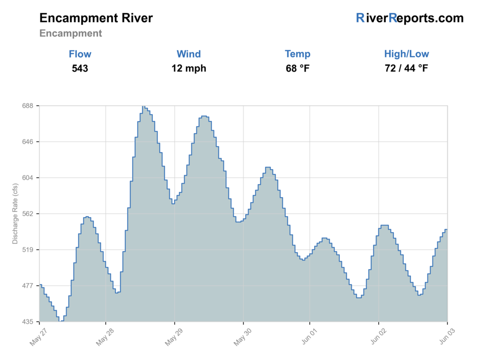
USGS data chart
Official USGS trend
Streamflow over the latest USGS reporting window.
Latest
543 cfs
Jun 3, 4 PM UTC
Weather
River weather report
Weather can change wading safety, road access, water temperature, hatches, and the best time of day to fish.
Live forecast loads as you reach this section
This keeps the report fast while still using the official National Weather Service forecast point.
Hatches and flies
Hatch chart and fly picks
March to April
Midges, little black stones, BWOs, and cold-water nymph windows
Zebra midge, black stonefly, BWO emerger, pheasant tail, perdigon
May to June
Runoff edges, caddis, PMDs, and stonefly activity where the river opens up
Stonefly nymph, caddis pupa, PMD emerger, elk hair caddis, rubber legs
July to September
Caddis, PMDs, terrestrials, ants, beetles, and hopper banks
Chubby Chernobyl, hopper, ant, beetle, X-caddis, parachute Adams
October to winter
BWOs, midges, and short streamer windows in colder water
BWO emerger, midge pupa, olive bugger, sculpin, soft hackle
Dry flies
Chubby Chernobyl, parachute Adams, PMD, BWO, elk hair caddis, ant, beetle
Best when trout are looking up and the banks or meadow edges let you stalk fish cleanly.
Nymphs
Pheasant tail, hare's ear, perdigon, zebra midge, caddis pupa, stonefly
The default choice for runoff edges, cold mornings, and faster slots.
Streamers
Olive bugger, black leech, small sculpin, sparse articulated baitfish
Useful when weather knocks color into the river or bigger fish hug undercuts.
Tactics
How to fish it
Start at Baggot Rocks if you need a clear public-access answer before committing more time and fuel.
On higher flows, fish softer banks and tailouts instead of forcing mid-current hero wades.
If you go upstream, budget more time for walking and log obstacles than the map suggests.
Use the gauge to decide whether the day is a lower-river plan or a full move to another drainage.
Rigging
Rod, leader, and setup notes
A 4- or 5-weight covers most trout plans here, with enough backbone for wind and larger pocket water.
Carry a dry-dropper and a compact streamer option because canyon shade and runoff tint can change the best presentation fast.
Longer leaders help in low clear water, but weight and shorter drifts win more often when the current is still quick.
Access
Access and planning notes
Baggot Rocks public access
Best first public readWade / float / trail
WGFD easement / wade
When to pick it
Start here when the gauge is stable and you want a legal, lower-river answer before hiking farther.
Caution
No camping, no fires, and winter road or parking limits still need current checks.
Encampment wilderness corridor
Higher-effort trout planWade / float / trail
Trail / canyon wade
When to pick it
Use this only when runoff is down, roads are passable, and you have time for deadfall or trail delays.
Caution
Downed trees and cold current can consume the day before fishing does.
Riverside and lower scouting stops
Quick clarity and edge checkWade / float / trail
Roadside scout / short wade
When to pick it
Pick this when you need to decide whether the lower river has fishable seams.
Caution
Do not assume every attractive roadside bank is public or safe.
Wyoming Game and Fish says the Baggot Rocks easement has two parking areas and one mile of pedestrian fishing access.
The same access page notes no camping, no campfires, and no winter plowing on the access road or parking areas.
The Forest Service warns that yearly downed trees can limit upstream wilderness access, so do not overpromise the backcountry plan.
Regulations
Check before fishing
Check Wyoming fishing regulations and the 2026 update notes before fishing because tackle and harvest changes can shift by region and water type.
Primary base
Encampment, Riverside, and the Sierra Madre approach roads
Best day style
Public easement bank access plus trail-based canyon and wilderness options
Check first
Wyoming regulations, 2026 changes, the 06625000 trend, Baggot Rocks access conditions, and whether the trail corridor is actually passable
Safety
Snowmelt push, cold canyon current, downed trees, rough roads, and winter roads that may not be plowed
Gear
Helpful gear for this water
4- to 6-weight rod
Covers dries, nymphs, small streamers, and afternoon wind.
Thermometer
Essential for summer trout ethics on lower or meadow reaches.
Wading staff
A smart default on slick cobble, undercut banks, and fast tailouts.
Layers and rain shell
Mountain weather turns quickly even on bright mornings.
Nearby water
Other water to research
Backup logic
Runoff or high cold water
Avoid crossings and compare Snake River, Wind River, or Shoshone River.
Deadfall or rough roads
Stay with Baggot Rocks or choose a less trail-dependent route.
Heat
Fish early, check temperature, and stop trout handling if recovery looks weak.
Access uncertainty
Stay within signed public access rather than guessing at ranch or trail boundaries.
Snake River
A more famous Wyoming trout plan with different access, pressure, and float logistics.
Wind River
An upstream Wyoming trout option when you want a broader river and different terrain.
Shoshone River
A Cody-area alternative with different flow management and easier road orientation.
FAQ
Fast answers
Is Encampment River fishable today?
Encampment River looks very fishable right now. The live score is 96/100, based on current flow, weather, public alerts, and the report's planning context. Recheck the linked gauge and forecast before leaving because conditions can change quickly after rain, heat, access changes, or flow swings.
What flow is best for Encampment River?
Best once runoff drops into distinct green seams. Stable summer flows give you the most flexible mix of access options.
When should I skip Encampment River?
Skip when the lower easement has no soft edges or when the upstream trail corridor is blocked enough to waste the day.
Is Encampment River safe to wade right now?
The fishability score is not a wading guarantee. Wade only where your chosen access has safe edges, clear footing, legal entry, and no forced crossings; high, rising, stained, or storm-affected water should be treated conservatively.
Where should I start on the Encampment River?
Start at Baggot Rocks near Riverside if you want the clearest official public access, then decide whether the river is good enough to justify more rugged upstream walking.
What should I watch on the Encampment River besides the gauge?
Watch for runoff color, road conditions, winter-plowing limits, and whether the upstream trail corridor is blocked by downed trees.
When is the Encampment River worth skipping?
Skip when runoff is still pushing hard, when the lower easement has no safe edges, or when the upstream trail plan looks more like obstacle management than fishing.
Sources
Source set for this report
Reviewed 2026-06-02