
West Virginia / Southeast
Dry Fork
A Dry Fork report focused on the lower and middle stocked-trout corridor around Hendricks, Harman, and Gladwin, with live flow checks and reach-specific guardrails.
Image: Generated Tucker County planning image for Dry Fork / BlueStreamFly generated; not exact location / BlueStreamFlyFishability now: Dry Fork fishability today
GreatData confidence: High96/100
Fishable now because HENDRICKS gauge is falling, weather is mild, and no public alert is active.
Flow observed
4:30 PM UTC
Weather observed
5:00 PM UTC
Score calculated
5:24 PM UTC
Why this rating
Flow
Weather
Public alerts
Next 6-12 hours
Improving / hold
A falling gauge and usable weather should keep the next 6-12 hours in play unless tributaries stain or heat builds.
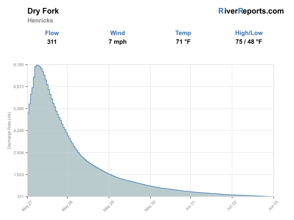
USGS flow
309 cfs
Current trend: flow falling, rating likely holding strong unless weather or clarity changes.
More planning details: flies, flow bands, and live source checks
Fish it today
Start here
Pick one named stocked reach, fish it well, then move only if the next official section clearly improves the day.
Best flow clue
Best when the Hendricks graph is stable or easing down and the mainstem still shows defined seams and bank edges.
Skip trigger
Skip muddy spikes, heavy snowmelt, or crowded stocking-day conditions that push you toward unclear access choices.
Flow decision bands
Stable cool Hendricks flow
This is the best signal for stocked roadside runs, riffle tails, and undercut banks in named public sections.
Fresh rain or snowmelt bump
Wait for the graph to settle before moving between pull-offs or assuming the next reach is safer.
Low clear stocked water
Fish lighter rigs, avoid overworking obvious pools, and watch temperature and pressure.
Fast dirty mainstem
A clear skip signal for the lower and middle roadside trout plan.
USGS flow
309 cfs
Current trend: flow falling, rating likely holding strong unless weather or clarity changes.
Live USGS flow
309 cfs / falling about 43%
Live NWS forecast
70F / Sunny
Water temperature not verified
Heat guidance uses weather and river type unless an official water-temperature value is available.
No NWS alert flag
No active NWS alert was returned for this forecast point.
WVDNR's 2026 rules and trout map both identify Dry Fork as a stocked trout stream in the Randolph-Tucker corridor.
The District 1 fishing guide breaks Dry Fork into reach-specific stocked access around communities and tributaries such as Harman, Gladwin, Elk Lick Run, and Red Run.
Use RiverReports for trend and USGS 03065000 at Hendricks as the official flow check before you commit to a roadside reach.
If the river is climbing or dirty, do not force a broad search. Pick one named stocked section or move to backup water.
Editorial review
How this report is maintained
This report starts with official regulation, access, flow, weather, and public-water sources, then adds practical planning guidance for fly anglers.
Byline
BlueStreamFly editorial desk
Reviewed by
BlueStreamFly source review
Maintained by
BlueStreamFly
Last material review
2026-06-03
Report confidence
Good confidence
88/100
Good confidence: RiverReports, USGS 03065000 at Hendricks, West Virginia regulation sources, WVDNR trout map and District 1 guide, stream-access context, weather data, and route-specific Dry Fork guidance support the page. Confidence is moderated by reach-specific public access, stocking pressure, snowmelt and rain spikes, private-ground boundaries, and summer trout temperature.
Regulations
West Virginia fishing regulations and trout map sources support current legal and stocked-water checks.
Access
WVDNR District 1 and stream-access sources support public planning, with exact pull-offs and private boundaries still requiring day-of care.
Flow and weather
RiverReports, USGS 03065000 at Hendricks, and the National Weather Service point support live flow and weather decisions.
Fishing usefulness
The page now separates Hendricks flow, guide-listed reach choice, stocked-water pressure, muddy and snowmelt skips, access limits, and West Virginia backup choices.
Fishability dashboard and source review
2026-06-03 / material content or source review
RiverReports, USGS 03065000 at Hendricks, West Virginia regulations, WVDNR trout map and District 1 access guide, WVDNR stream-access context, National Weather Service point data, and route-specific stocked-trout safety guidance were checked before updating the current-fishability decision layer.
2026-06-03
Updated Dry Fork to the current fishability-page standard with Hendricks flow bands, guide-listed reach access cards, rain and snowmelt backup cues, stable fishability SEO, and confidence signals.
2026-05-27
Published a new Dry Fork page with stocked-reach access guidance, RiverReports plus USGS flow support, and clear scope limits around the lower and middle river.
Angler planning edge
Local details that change the plan
Best for
Stocked-trout roadside planning, Cool spring and fall sessions, Anglers who want a clear public-reach structure
Wade or float
Wade it. The official guidance is reach-by-reach roadside trout access, not a float-first river day.
Best flows
Best when the Hendricks graph is stable or easing down and the mainstem still shows defined seams and bank edges.
When to skip
Skip muddy spikes, heavy snowmelt, or crowded stocking-day conditions that push you toward unclear access choices.
Local plan
Pick one named stocked reach, fish it well, then move only if the next official section clearly improves the day.
Pressure
Pressure concentrates around the easiest stocked sections in spring, but spreads out once the put-and-take rush fades.
Access nuance
The best Dry Fork trips respect the guide's reach language instead of wandering into side water or unclear private-ground shortcuts.
Backup water
Move to Blackwater, Cranberry, or the South Branch Potomac when flow or crowding makes Dry Fork feel too narrow.
About the river
Setting, character, and why it fishes the way it does.
Dry Fork runs through one of the colder mountain corridors in northeastern West Virginia and gives anglers a trout-centered alternative to the warmwater rivers farther downstream. The most trustworthy way to fish it is to follow the WVDNR reach structure, because that is where the public-access and stocking information is actually clear.
That reach structure matters. Official sources treat Dry Fork as a series of useful public sections instead of one uniform fishery. This page therefore stays anchored to the lower and middle river around the Hendricks gauge, where the official access and flow pairing make the most sense together.
Think of Dry Fork as a stocked-trout planning page with some holdover potential, not as proof that every feeder and named branch is equally open or equally fishable.
Target species
Rainbow trout
A core stocked target and often the most visible fish in the guide-listed public sections.
Brown trout
A realistic second target in deeper runs, undercuts, and lower-pressure windows.
Brook trout
Present in the broader system, but better treated here as a supporting species rather than the lead identity of the gauge reach.
Reading the water
Stable cool flow
Best for covering stocked runs, riffle tails, and softer banks with nymphs or a dry-dropper.
Fresh rain bump
Sometimes fishable after it settles, but not a good excuse to treat every roadside turnout as safe or productive.
Low clear flow
Scale down rigs, fish early and late, and move carefully around the most obvious stocked pools.
Fast, dirty, or snowmelt-heavy
A skip signal on the roadside trout plan, even if the river still looks tempting from the bridge.
Best seasons
Spring
The classic stocked-trout period when flows cooperate and the public sections are in shape.
Early summer
Still good on cooler weeks, especially if you fish early and stay inside cleaner public runs.
Fall
A strong period for less-crowded trout fishing after summer heat breaks.
Winter
Possible on mild stable days, but road conditions, cold water, and ice narrow the safe window quickly.
Preferred flow source
DRY FORK AT HENDRICKS, WV
RiverReports is the preferred chart source when coverage exists. When a matching USGS gauge exists, keep it open as the official backstop for station data and current hydrograph context.
USGS data chart
Official USGS trend
Streamflow over the latest USGS reporting window.
Latest
309 cfs
Jun 3, 4 PM UTC
Weather
River weather report
Weather can change wading safety, road access, water temperature, hatches, and the best time of day to fish.
Live forecast loads as you reach this section
This keeps the report fast while still using the official National Weather Service forecast point.
Hatches and flies
Hatch chart and fly picks
Early spring
Midges, small black stones, and cold-water nymph windows
Zebra midge, pheasant tail, black stonefly, hare's ear
Late spring to early summer
Caddis, sulphurs, March Browns, and attractor-dry pocket-water fishing
Elk hair caddis, sulphur emerger, March Brown, stimulator
Summer
Terrestrials, caddis, and short dry-dropper windows around shade and broken water
Foam ant, beetle, tan caddis, attractor dry, perdigon
Fall to winter
BWOs, midges, and sparse streamer windows
BWO nymph, zebra midge, RS2, olive bugger
Nymphs
Pheasant tail, hare's ear, perdigon, zebra midge, small stonefly
The day-starting choice for stocked water, higher flow, and cold-weather trout.
Dry-dropper flies
Stimulator, elk hair caddis, parachute Adams, foam ant
Best once flows settle and you can cover riffles, pocket water, and softer banks without spooking every lie.
Small streamers
Olive bugger, black bugger, leech, compact sculpin
Useful after rain bumps, during fall brown-trout windows, or when larger fish hug undercuts and buckets.
Tactics
How to fish it
Pick one guide-listed reach and fish it carefully instead of trying to stitch together the whole river from random bridge looks.
Start with nymphs through the stocked runs and deeper seams, then add a dry-dropper once the water and light make surface looks realistic.
Use short accurate casts around undercuts and bank shade where holdover fish can separate themselves from freshly stocked fish.
If the river is too high or too crowded, move to backup water rather than expanding into tributary water this page is not trying to cover.
Rigging
Rod, leader, and setup notes
A 4- or 5-weight with floating line is the right all-around Dry Fork tool.
Carry split shot, yarn or small indicators, and a compact nymph box first; streamer fishing is secondary here.
A short net and wading staff matter more than a heavy pack on the roadside sections.
Keep spare layers dry because cold spring weather and wet roads can turn routine trout fishing into a comfort problem fast.
Access
Access and planning notes
Hendricks and Gladwin guide-listed reaches
Primary stocked-trout frameworkWade / float / trail
Roadside / bank / wade
When to pick it
Start here when the gauge and WVDNR reach guidance both support a controlled trout day.
Caution
Reach-specific guidance is not permission to fish every bridge or field edge.
Harman corridor
Upper end of this page's mainstem scopeWade / float / trail
Roadside / stocked reach / wade
When to pick it
Use it when lower pressure or better clarity makes the upper guide-listed water more useful.
Caution
Upper and tributary water can carry different access and rule complexity.
Elk Lick and nearby roadside sections
Narrowing the day to one named sectionWade / float / trail
Roadside scout / short wade
When to pick it
Pick it when crowding or flow makes a smaller named section easier to manage.
Caution
Do not drift into unclear private ground or side-water assumptions.
This page stays on the lower and middle mainstem because the official guide is reach specific and some nearby water carries extra special-regulation complexity.
Use public roads, signed access, and guide-backed sections. Do not assume every bridge shoulder or field edge is legal entry.
Crowds can bunch into the easiest stocked reaches during spring. First light or weekday windows are usually cleaner.
Regulations
Check before fishing
Check West Virginia fishing regulations, the current trout-stocking map, and the WVDNR District 1 guide before fishing Dry Fork. This page is scoped to the lower and middle stocked public reaches around the Hendricks gauge and should not be treated as blanket guidance for every tributary.
Primary base
Hendricks, Harman, Parsons, and Tucker County's public-road corridor
Best day style
Roadside stocked-trout pull-offs, short wading sessions, and reach-by-reach public access decisions
Check first
West Virginia regulations, the trout map, the District 1 guide reach you want, and the 03065000 trend before committing to a specific section
Safety
Fast rain rises, cold spring water, slippery cobble, and accidentally drifting from public roadside access into private ground
Gear
Helpful gear for this water
4- or 5-weight rod
Covers indicators, dry-dropper rigs, and the small streamers these rivers reward.
Wading staff
Helpful on slick Appalachian cobble, railroad-grade approaches, and short but pushy crossings.
Thermometer
Worth carrying whenever stocked or holdover trout are part of the plan in late spring and summer.
Rain shell and dry bag
Mountain storms can turn a good trout day into a fast-rising access problem.
Nearby water
Other water to research
Backup logic
Muddy or snowmelt-heavy
Compare Blackwater River, Cranberry River, or South Branch Potomac after checking each route's current flow.
Crowded stocked reach
Move to another named public reach or wait for a lower-pressure window.
Warm trout conditions
Fish only a cool short session or stop trout pressure.
Access uncertainty
Stay with WVDNR guide-backed sections instead of improvising at bridges.
Blackwater River
A stocked high-country trout option when you want a smaller state-park-oriented corridor.
Cranberry River
A stronger Monongahela trout corridor if Tucker County weather or pressure closes the Dry Fork window.
South Branch Potomac River
A better mixed trout-to-smallmouth fallback when Dry Fork is too high or too crowded.
FAQ
Fast answers
Is Dry Fork fishable today?
Dry Fork looks very fishable right now. The live score is 96/100, based on current flow, weather, public alerts, and the report's planning context. Recheck the linked gauge and forecast before leaving because conditions can change quickly after rain, heat, access changes, or flow swings.
What flow is best for Dry Fork?
Best when the Hendricks graph is stable or easing down and the mainstem still shows defined seams and bank edges.
When should I skip Dry Fork?
Skip muddy spikes, heavy snowmelt, or crowded stocking-day conditions that push you toward unclear access choices.
Is Dry Fork safe to wade right now?
The fishability score is not a wading guarantee. Wade only where your chosen access has safe edges, clear footing, legal entry, and no forced crossings; high, rising, stained, or storm-affected water should be treated conservatively.
Is this Dry Fork page for the whole watershed?
No. It is a lower- and middle-mainstem page built around the Hendricks gauge and the guide-listed stocked public reaches. Treat tributaries and special-regulation branches as separate planning problems.
What should I check before fishing Dry Fork?
Check the current West Virginia regulations, the trout-stocking map, your intended reach in the District 1 guide, and the USGS 03065000 trend before choosing a pull-off.
Can I just stop at any bridge on Dry Fork?
That is not the safest way to use the page. Stay with public roadside and guide-backed reaches unless you have clear permission or legal access information for another entry.
Sources
Source set for this report
Reviewed 2026-06-03