
Washington / Pacific Northwest
Quinault River
A Quinault report for Olympic Peninsula valley planning with live flow checks, park and forest access guidance, and practical salmonid trip decisions.
Image: Generated Olympic Peninsula planning image for Quinault River / BlueStreamFly generated; not exact location / BlueStreamFlyFishability now: Quinault River fishability today
GoodData confidence: High74/100
Fishable now because flow has been checked, weather is mild, and no public alert is active.
Flow observed
Not returned
Weather observed
5:00 PM UTC
Score calculated
5:24 PM UTC
Why this rating
Flow
Weather
Public alerts
Next 6-12 hours
Hold
Stable live data supports staying with the plan, but recheck the gauge and forecast before leaving.
USGS flow
Check gauge
Current trend: previous-score comparison will become more useful after repeated live checks.
More planning details: flies, flow bands, and live source checks
Fish it today
Start here
Base around Lake Quinault, check current rules and the upper-river trend, then choose an upper-valley bank/wade plan or a clearly separate lower-river option.
Best flow clue
Use the above-lake gauge as a trend signal, then read the actual water at your access. Stable or dropping flow with open roads is best.
Skip trigger
Skip when storm damage affects roads, rules are uncertain, the river is rising, or the plan blurs upper-river wading with lower-river boat context.
Flow decision bands
Stable above-lake flow
Stable or slowly falling USGS 12039380 flow is the best upper Quinault trend signal.
Best valley window
Open roads, current legal rules, safe bars, and a reach-specific upper or lower plan make the route most useful.
Storm rise or road issue
Rainforest storms, road damage, or rising water should simplify or cancel the plan.
Reach-scope confusion
Do not use upper-river flow to assume the lake, outlet, or lower-river boat section fishes the same way.
USGS flow
Check gauge
Current trend: previous-score comparison will become more useful after repeated live checks.
No current flow value
The source loaded, but did not return streamflow or gauge height.
Live NWS forecast
56F / Mostly Cloudy
Water temperature not verified
Heat guidance uses weather and river type unless an official water-temperature value is available.
No NWS alert flag
No active NWS alert was returned for this forecast point.
Olympic National Park's fishing page and current law-and-policy notices show that Quinault rules can tighten when wild steelhead or other conservation issues demand it.
The Quinault area brochure and visiting page give the clearest official picture of roads, campgrounds, ranger-station access, and storm-sensitive valley travel.
Park boating guidance says fishing from a boat is permitted below the North Shore Quinault River Bridge, which helps define the lower-river boundary for boat planning.
Lake influence and valley scale mean the upper-river gauge is best used as a trend signal, not as an excuse to ignore what the river looks like at your access point.
Editorial review
How this report is maintained
This report starts with official regulation, access, flow, weather, and public-land sources, then adds practical planning guidance for fly anglers.
Byline
BlueStreamFly editorial desk
Reviewed by
BlueStreamFly source review
Maintained by
BlueStreamFly
Last material review
2026-06-02
Report confidence
High confidence
89/100
High confidence: RiverReports, USGS above-lake flow, Washington regulations and emergency rules, coastal steelhead context, Olympic park fishing and boating sources, Quinault valley access and policy sources, weather coverage, image disclosure, and route-specific valley guidance support the page. Confidence is moderated by storm damage, reach scope, rule volatility, lake influence, and lower-river boat-boundary details.
Regulations
Washington rules, emergency rules, coastal steelhead context, Olympic National Park fishing rules, and park policy sources support the legal-check path.
Access
Olympic National Park Quinault area, visiting, and boating sources strongly support valley and lower-river orientation.
Flow and weather
RiverReports coverage is backed by USGS 12039380 above Quinault Lake, and the National Weather Service point supports rain and storm decisions.
Fishing usefulness
The page now separates upper-river flow, lake and valley access, lower-river boat-boundary context, storm road issues, rule checks, and backup-water choices.
Fishability dashboard and source review
2026-06-02 / material content or source review
RiverReports, USGS 12039380 above Quinault Lake, Washington sport-fishing and emergency-rule sources, WDFW coastal steelhead context, Olympic National Park fishing, boating, Quinault access, laws and policy sources, National Weather Service data, and image-disclosure sources were checked before updating the current-fishability decision layer.
2026-06-02
Updated Quinault River to the current fishability-page standard with upper-river trend bands, Lake Quinault valley and boat-boundary access cards, storm and reach-scope skip cues, backup logic, stable fishability SEO, and confidence signals.
2026-05-27
Published a new Quinault River report with upper-river flow planning, valley access anchors, and lower-river boat-boundary context tied to official sources.
Angler planning edge
Local details that change the plan
Best for
Olympic valley steelhead planning, upper-river gauge checks, less-remote west-side access decisions
Wade or float
Wade, bank fish, or plan lower-river boat context only after separating upper-river access above the lake from lower-river rules.
Best flows
Use the above-lake gauge as a trend signal, then read the actual water at your access. Stable or dropping flow with open roads is best.
When to skip
Skip when storm damage affects roads, rules are uncertain, the river is rising, or the plan blurs upper-river wading with lower-river boat context.
Local plan
Base around Lake Quinault, check current rules and the upper-river trend, then choose an upper-valley bank/wade plan or a clearly separate lower-river option.
Pressure
The valley is more approachable than the Queets, so day-use traffic and easy scenery can distract from flow and rule discipline.
Access nuance
Park, forest, lake, upper river, and lower river context should stay separate in the decision.
Backup water
Compare Queets for a wilder plan, Hoh for a Highway 101 read, or Bogachiel for easier Forks-area public access.
About the river
Setting, character, and why it fishes the way it does.
The Quinault valley combines Olympic National Park and Olympic National Forest access, which makes it one of the more approachable west-side valleys for planning. That does not make the river simple; it just gives you more official places to orient the day.
Compared with the Hoh and Queets, the Quinault offers a broader day-use framework with scenic loop-drive context, ranger information, and a more obvious valley hub. The fishing still hinges on rules and flow, not scenery.
This page focuses on upper and middle Quinault planning anchored by the official upper-river gauge and public valley access sources. It does not assume every lake outlet or lower-river stretch fishes the same way.
Target species
Steelhead
An important part of the river's identity only when current regulations support it.
Salmon
Seasonal and highly sensitive to exact openings, closures, and handling rules.
Cutthroat trout
A better fit for lower-water windows and lighter presentations.
Char
Protected fish that should be handled as release-only encounters.
Reading the water
Stable moderate flow
Best for upper-river wading, nymphing, and realistic bar access.
Storm rise
Wait it out; valley roads may stay open while the river itself stops being reasonable.
Low clear summer flow
Shift toward stealth and trout or cutthroat-style expectations.
Big autumn water
Good only when the legal target and safe access are both clearly defined.
Best seasons
Winter
Steelhead-oriented when legal and when the upper trend is not too high.
Spring
Useful after storms only if the river drops into manageable shape.
Summer
Better for scouting, cutthroat, and lighter valley fishing expectations.
Fall
Salmon timing and changing weather make careful reach planning essential.
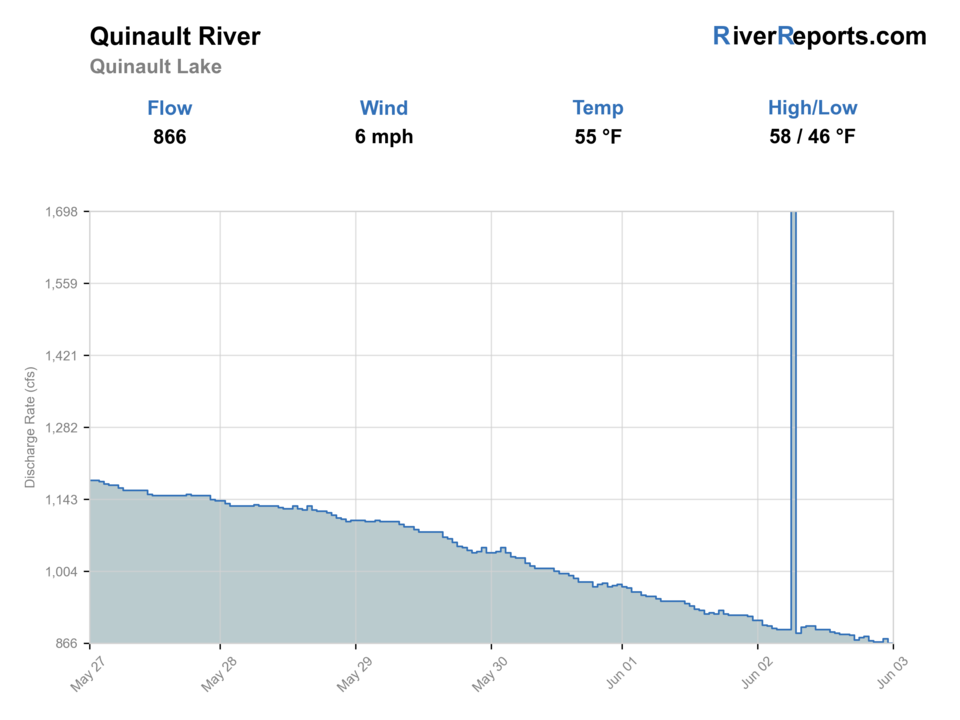
Preferred flow source
Quinault River above Quinault Lake near Quinault
RiverReports is the preferred chart source when coverage exists. When a matching USGS gauge exists, keep it open as the official backstop for station data and current hydrograph context.
USGS data chart
Official USGS trend
Streamflow over the latest USGS reporting window.
Weather
River weather report
Weather can change wading safety, road access, water temperature, hatches, and the best time of day to fish.
Live forecast loads as you reach this section
This keeps the report fast while still using the official National Weather Service forecast point.
Hatches and flies
Hatch chart and fly picks
Winter
Sparse midges, stonefly nymph activity, egg windows around salmon and steelhead water
Black or purple intruder, marabou tube, egg pattern, stonefly nymph
Spring
Skwala-style stoneflies, March browns, caddis, streamer windows in dropping flow
Stonefly nymph, olive bugger, soft hackle, March brown dry
Summer
Caddis, small mayflies, terrestrials on softer edges and side channels
Elk hair caddis, parachute Adams, beetle, hopper-dropper, beadhead nymph
Fall
Caddis, October caddis, eggs, and baitfish-style streamer windows around salmon traffic
October caddis dry, egg pattern, flesh fly, sculpin streamer
Swing flies
Black-and-blue intruder, purple marabou, sparse leech, traditional hairwing
Use in winter and spring steelhead windows when flows are green enough to swing slower edges and tailouts.
Trout and cutthroat dries
Elk hair caddis, parachute Adams, stimulator, foam beetle
Best in summer and early fall when lower water opens softer seams, pocket edges, and side channels.
Nymphs and indicators
Stonefly nymph, perdigon, hare's ear, egg, caddis pupa
Useful when the river is cold, slightly colored, or too pushy for an efficient swing-only approach.
Tactics
How to fish it
Use the upper-river gauge to frame the day, then read the actual water at your access point before you rig.
If the lower river is part of the plan, separate boat-legal sections from upper-valley wading assumptions.
On moderate water, fish inside bars and tailouts patiently because the Quinault rarely rewards rushed big-river coverage.
When the valley is busy, move less and fish better instead of spending the day driving loop roads.
Rigging
Rod, leader, and setup notes
A 6- or 7-weight covers most Quinault planning on this page, with a heavier setup reserved for truly big-water steelhead days.
Carry sink tips and nymph tools so you can follow clarity instead of forcing one style.
A rain shell and traction are standard, not optional, because the valley is wet even when the forecast looks mild.
Access
Access and planning notes
Above Quinault Lake gauge
Primary upper-river trendWade / float / trail
RiverReports / USGS gauge / steelhead
When to pick it
Start here when upper-river flow direction decides the day.
Caution
The gauge is a trend source, not proof that every lake or lower-river section is fishable.
Lake Quinault valley corridor
Road and access baseWade / float / trail
Park and forest corridor / bank / scout
When to pick it
Use it when roads, ranger information, and day-use access help frame the plan.
Caution
Storm damage and posted limits can matter even when the graph looks reasonable.
North Shore Quinault River Bridge context
Lower-river boat boundaryWade / float / trail
Boat-aware / lower river / rule check
When to pick it
Pick it only when lower-river rules and flow support a separate boat-aware plan.
Caution
Do not blur lower-river boat rules with upper-valley wading assumptions.
Storm damage can affect valley roads and trailheads even when the river looks reasonable on a chart.
Upper-river and lower-river plans should not be blurred together just because they share the same river name.
The valley is accessible by Olympic standards, but the river still deserves big-river caution.
Regulations
Check before fishing
Check Washington sport fishing rules, current emergency rule changes, and Olympic National Park regulations before fishing the Quinault. Reach boundaries, steelhead and salmon rules, and park-specific handling requirements all matter.
Primary base
Lake Quinault valley, ranger-station corridor, and upper-river pullouts above the lake
Best day style
Road-access valley pullouts, park and forest trailheads, and lower-river boat-aware sections
Check first
Washington and park rules, the 12039380 trend, valley road status, and whether you are fishing above or below the lake
Safety
Rainforest storms, broad slippery bars, road damage after weather, and lower-river scope confusion
Gear
Helpful gear for this water
6- to 8-weight rod
A 7-weight is the best all-around Olympic Peninsula choice when steelhead, salmon, and large trout water all matter.
Wading staff and studded traction
These rivers are slick, pushy, and log-strewn even when the banks look flat.
Rain shell and dry layers
Weather swings and rainforest humidity can turn a comfortable day into a cold one quickly.
Rubber net and quick release tools
Protected wild fish, char encounters, and selective-gear rules make fast in-water handling the right default.
Nearby water
Other water to research
Backup logic
Storm or road damage
Move to Hoh or Bogachiel only if their access and flow are cleaner.
High or rising water
Wait for the upper trend to settle before committing to bars.
Rule uncertainty
Choose a legally open route before planning for salmon or steelhead.
Reach mismatch
Pick one upper or lower plan instead of trying to make the whole valley fit one gauge.
Queets River
A wilder neighboring option when you want more remoteness and fewer developed valley anchors.
Hoh River
Another big west-side river with a more direct Highway 101 orientation.
Bogachiel River
A smaller-feeling Forks-area move when you want easier public access.
FAQ
Fast answers
Is Quinault River fishable today?
Quinault River looks fishable right now. The live score is 74/100, based on current flow, weather, public alerts, and the report's planning context. Recheck the linked gauge and forecast before leaving because conditions can change quickly after rain, heat, access changes, or flow swings.
What flow is best for Quinault River?
Use the above-lake gauge as a trend signal, then read the actual water at your access. Stable or dropping flow with open roads is best.
When should I skip Quinault River?
Skip when storm damage affects roads, rules are uncertain, the river is rising, or the plan blurs upper-river wading with lower-river boat context.
Is Quinault River safe to wade right now?
The fishability score is not a wading guarantee. Wade only where your chosen access has safe edges, clear footing, legal entry, and no forced crossings; high, rising, stained, or storm-affected water should be treated conservatively.
What gauge should I check for the Quinault River?
Use RiverReports for the quick chart and keep USGS 12039380 above Quinault Lake open as the official trend reference, then read the actual water at your chosen access point before fishing.
Can I fish the Quinault from a boat?
Olympic National Park says fishing from a boat is permitted below the North Shore Quinault River Bridge, so boat plans should stay tied to that lower-river context and current regulations.
Why is the Quinault a better fallback than the Queets for many anglers?
Because the valley has more developed orientation points, road information, and public visitor infrastructure, which makes it easier to build a disciplined day without the same level of remoteness.
Sources
Source set for this report
Reviewed 2026-06-02