
Washington / Pacific Northwest
Queets River
A Queets report for remote Olympic Peninsula planning with live flow checks, park access cautions, and realistic expectations for a large wild river.
Image: Generated Olympic Peninsula planning image for Queets River / BlueStreamFly generated; not exact location / BlueStreamFlyFishability now: Queets River fishability today
GreatData confidence: High96/100
Fishable now because the live gauge is stable, weather is mild, and no public alert is active.
Flow observed
4:30 PM UTC
Weather observed
5:00 PM UTC
Score calculated
5:23 PM UTC
Why this rating
Flow
Weather
Public alerts
Next 6-12 hours
Hold
Stable live data supports staying with the plan, but recheck the gauge and forecast before leaving.
USGS flow
862 cfs
Current trend: flow stable, so weather, temperature, and access checks drive the next change.
More planning details: flies, flow bands, and live source checks
Fish it today
Start here
Commit to one lower-river access plan, fish a short controlled session, and leave enough daylight to turn around early.
Best flow clue
Use the Clearwater gauge with road, rule, and weather checks. Green, stable, or dropping water is the only time the Queets starts to feel predictable.
Skip trigger
Skip when the graph is rising, road or trail conditions are uncertain, park or WDFW rules are unclear, or the plan requires aggressive wading.
Flow decision bands
Green and stable
Stable or slowly falling USGS Clearwater flow with green water is the best Queets signal.
Best remote-window setup
Open rules, road confidence, manageable weather, and obvious retreat routes make the route most useful.
High or storm cycle
Rising rain flow, wet wood, rough bars, or storm-damaged access should cancel the fishing plan.
Remote margin problem
Uncertain roads, fading daylight, or aggressive wading needs can make the Queets a poor call even when the graph looks plausible.
USGS flow
862 cfs
Current trend: flow stable, so weather, temperature, and access checks drive the next change.
Live USGS flow
862 cfs / stable
Live NWS forecast
57F / Mostly Cloudy
Water temperature not verified
Heat guidance uses weather and river type unless an official water-temperature value is available.
No NWS alert flag
No active NWS alert was returned for this forecast point.
Olympic National Park's fishing page and rule documents are critical because the Queets has had conservation-driven closures and special handling requirements.
The boating page confirms that fishing from a boat is allowed below Tshletshy Creek, which helps define the lower-river access picture without overstating it.
The Queets area brochure is a better access-planning source than generic map apps because the valley is remote and conditions change.
This river punishes late decisions, weak retreat plans, and romantic assumptions about wading big rainforest water.
Editorial review
How this report is maintained
This report starts with official regulation, access, flow, weather, and public-land sources, then adds practical planning guidance for fly anglers.
Byline
BlueStreamFly editorial desk
Reviewed by
BlueStreamFly source review
Maintained by
BlueStreamFly
Last material review
2026-06-02
Report confidence
High confidence
88/100
High confidence: RiverReports, USGS Clearwater flow, Washington regulations and emergency rules, WDFW coastal steelhead context, Olympic park fishing and boating sources, Queets access and condition sources, weather coverage, image disclosure, and route-specific remote-river guidance support the page. Confidence is moderated by road and storm damage, emergency rules, remoteness, boat-section limits, wood, and heavy current.
Regulations
Washington rules, emergency rules, coastal steelhead context, and Olympic National Park fishing rules support the legal-check path.
Access
Olympic National Park Queets access, boating, and condition sources support the remote public-corridor plan.
Flow and weather
RiverReports coverage is backed by USGS 12040500 near Clearwater, and the National Weather Service point supports rain and storm decisions.
Fishing usefulness
The page now separates Clearwater flow, remote road access, park rules, boat-section limits, storm damage, retreat margin, and backup-water choices.
Fishability dashboard and source review
2026-06-02 / material content or source review
RiverReports, USGS 12040500 near Clearwater, Washington sport-fishing and emergency-rule sources, WDFW coastal steelhead context, Olympic National Park fishing and boating sources, Queets area access and trail-condition sources, National Weather Service data, and image-disclosure sources were checked before updating the current-fishability decision layer.
2026-06-02
Updated Queets River to the current fishability-page standard with Clearwater trend bands, remote park-corridor and boat-section access cards, road and storm skip cues, backup logic, stable fishability SEO, and confidence signals.
2026-05-27
Published a new Queets River report with remote-access caution, boat-section context, and official-source flow guidance for west-side Olympic planning.
Angler planning edge
Local details that change the plan
Best for
experienced remote-river planning, wild Olympic steelhead context, lower-river go/no-go decisions
Wade or float
Wade only where retreat is obvious and float only when lower-river rules, access, and crew skill are current; the default should be conservative.
Best flows
Use the Clearwater gauge with road, rule, and weather checks. Green, stable, or dropping water is the only time the Queets starts to feel predictable.
When to skip
Skip when the graph is rising, road or trail conditions are uncertain, park or WDFW rules are unclear, or the plan requires aggressive wading.
Local plan
Commit to one lower-river access plan, fish a short controlled session, and leave enough daylight to turn around early.
Pressure
Crowding is rarely the main issue; commitment quality and remote-margin planning are.
Access nuance
Remote public corridor access is not the same as easy access. Road, weather, and park context decide whether the drive is worth it.
Backup water
Move to Quinault for a less remote Olympic valley, Hoh for a more familiar Highway 101 read, or Bogachiel for easier Forks-area access.
About the river
Setting, character, and why it fishes the way it does.
The Queets is famous because it preserves nearly an entire rainforest valley from source to sea, not because it is easy. That wildness is the main value and the main complication for anglers.
Unlike a more developed river corridor, the Queets asks you to solve weather, flow, and access before you ever make a presentation. The fishing is secondary to the planning discipline.
A useful public report for the Queets should help anglers know when to skip the drive, not just when to get excited about it.
Target species
Steelhead
A classic target only when current park and state rules allow it.
Salmon
Iconic to the drainage, but highly sensitive to season and conservation closures.
Sea-run cutthroat trout
A warmer-season lighter-gear possibility in lower-water periods.
Bull trout and Dolly Varden
Protected char that must be released where encountered.
Reading the water
Stable green flow
The only time the Queets starts to feel predictable enough for a real fishing plan.
High and pushy
A no-go for most bank anglers and a serious risk even for experienced boaters.
Low clear water
Fish quieter water and expect a more technical, less romantic day.
Storm cycle
The wrong moment to drive in unless you are scouting and ready to leave.
Best seasons
Winter
Steelhead context when open, but only on the river's terms.
Spring
Useful after storms only if the graph settles and access remains intact.
Summer
More of a cutthroat, scouting, or wilderness-valley visit than a broad steelhead promise.
Fall
Salmon timing and conservation sensitivity both intensify.
Preferred flow source
Queets River near Clearwater
RiverReports is the preferred chart source when coverage exists. When a matching USGS gauge exists, keep it open as the official backstop for station data and current hydrograph context.
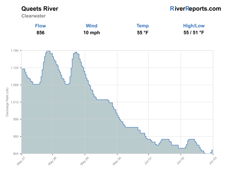
USGS data chart
Official USGS trend
Streamflow over the latest USGS reporting window.
Latest
862 cfs
Jun 3, 4 PM UTC
Weather
River weather report
Weather can change wading safety, road access, water temperature, hatches, and the best time of day to fish.
Live forecast loads as you reach this section
This keeps the report fast while still using the official National Weather Service forecast point.
Hatches and flies
Hatch chart and fly picks
Winter
Sparse midges, stonefly nymph activity, egg windows around salmon and steelhead water
Black or purple intruder, marabou tube, egg pattern, stonefly nymph
Spring
Skwala-style stoneflies, March browns, caddis, streamer windows in dropping flow
Stonefly nymph, olive bugger, soft hackle, March brown dry
Summer
Caddis, small mayflies, terrestrials on softer edges and side channels
Elk hair caddis, parachute Adams, beetle, hopper-dropper, beadhead nymph
Fall
Caddis, October caddis, eggs, and baitfish-style streamer windows around salmon traffic
October caddis dry, egg pattern, flesh fly, sculpin streamer
Swing flies
Black-and-blue intruder, purple marabou, sparse leech, traditional hairwing
Use in winter and spring steelhead windows when flows are green enough to swing slower edges and tailouts.
Trout and cutthroat dries
Elk hair caddis, parachute Adams, stimulator, foam beetle
Best in summer and early fall when lower water opens softer seams, pocket edges, and side channels.
Nymphs and indicators
Stonefly nymph, perdigon, hare's ear, egg, caddis pupa
Useful when the river is cold, slightly colored, or too pushy for an efficient swing-only approach.
Tactics
How to fish it
Decide whether you are fishing the lower river or simply verifying whether the day is worth continuing.
On safe lower bars, work slower inside lanes and protect your retreat route the whole session.
Do not chase mid-river fantasy water on foot; the Queets is not the place to prove toughness.
If the river is fishable but intimidating, shorten the day and keep the plan simple.
Rigging
Rod, leader, and setup notes
A 7- or 8-weight is the realistic default for the Queets because even modest fishable days are still big-water days.
Carry a waterproof pack, spare dry layers, and traction that can handle slick cobble and wet wood.
If boating, keep the setup clean and conservative; extra gear is less useful than a sharp access and safety plan.
Access
Access and planning notes
Clearwater gauge
Primary remote-river trendWade / float / trail
RiverReports / USGS gauge / steelhead
When to pick it
Start here when flow direction decides whether the drive is worth it.
Caution
The gauge does not replace park rules, road checks, or retreat planning.
Queets park corridor
Road and access reality checkWade / float / trail
Park corridor / bank / scout
When to pick it
Use it when the valley road and public access are part of the go/no-go decision.
Caution
Remote access, wet wood, and weather can turn a mediocre plan into a bad day.
Lower river below Tshletshy Creek
Boat-section contextWade / float / trail
Lower river / boat-aware / bank
When to pick it
Pick it only when current rules, flow, and crew skill support a lower-river plan.
Caution
Boat-permitted context is not a safe-flow guarantee.
The Queets is remote enough that a mediocre plan can become a bad day faster than on a more developed river.
Road and weather conditions matter as much as the hydrograph.
Remote access is not the same thing as safe access; choose shorter lower-river plans before bigger ambitions.
Regulations
Check before fishing
Check Washington sport fishing rules, current emergency rule changes, and Olympic National Park regulations before fishing the Queets. Conservation closures, protected species, and reach-specific rules can change the day completely.
Primary base
Queets and Clearwater corridor access with the park valley road as the day-shaping checkpoint
Best day style
Remote park-corridor access, rough bars, and boat-sensitive lower-river planning
Check first
Park regulations, the 12040500 trend, weather, remote road conditions, and whether the day is worth the drive at all
Safety
Remote access, no-easy-retreat bars, heavy current, wet wood, and storm damage risk
Gear
Helpful gear for this water
6- to 8-weight rod
A 7-weight is the best all-around Olympic Peninsula choice when steelhead, salmon, and large trout water all matter.
Wading staff and studded traction
These rivers are slick, pushy, and log-strewn even when the banks look flat.
Rain shell and dry layers
Weather swings and rainforest humidity can turn a comfortable day into a cold one quickly.
Rubber net and quick release tools
Protected wild fish, char encounters, and selective-gear rules make fast in-water handling the right default.
Nearby water
Other water to research
Backup logic
High or rising water
Wait or compare Quinault and Hoh only if they are falling and legally open.
Road or storm damage
Move to Bogachiel or another route with easier current access.
Emergency rule issue
Choose a legally open Washington river before choosing flies.
Remote-margin problem
Shorten the day, scout only, or leave the valley early.
Quinault River
A less remote Olympic option with more developed valley orientation.
Hoh River
Another large rainforest river, but with more familiar Highway 101-based planning.
Bogachiel River
The easiest access backup if the Queets feels too remote for current conditions.
FAQ
Fast answers
Is Queets River fishable today?
Queets River looks very fishable right now. The live score is 96/100, based on current flow, weather, public alerts, and the report's planning context. Recheck the linked gauge and forecast before leaving because conditions can change quickly after rain, heat, access changes, or flow swings.
What flow is best for Queets River?
Use the Clearwater gauge with road, rule, and weather checks. Green, stable, or dropping water is the only time the Queets starts to feel predictable.
When should I skip Queets River?
Skip when the graph is rising, road or trail conditions are uncertain, park or WDFW rules are unclear, or the plan requires aggressive wading.
Is Queets River safe to wade right now?
The fishability score is not a wading guarantee. Wade only where your chosen access has safe edges, clear footing, legal entry, and no forced crossings; high, rising, stained, or storm-affected water should be treated conservatively.
What gauge should I check for the Queets River?
Use RiverReports for the quick view and keep USGS 12040500 near Clearwater open as the official backup when you decide whether the lower river is stable enough to fish.
Is the Queets a good beginner steelhead river?
Usually no. It is remote, large, and punishment-oriented when flow or access is even slightly off, so it is a better river for disciplined planning than for a first blind steelhead drive.
Can I boat the Queets?
Olympic National Park says fishing from a boat is permitted below Tshletshy Creek, which gives lower-river boaters a defined rule framework but not an automatic green light on unsafe flows.
Sources
Source set for this report
Reviewed 2026-06-02