
Washington / Pacific Northwest
Bogachiel River
A Bogachiel report for Forks-area planning with live flow checks, Olympic Peninsula access anchors, steelhead caution, and practical rain-driven decision points.
Image: Generated Olympic Peninsula planning image for Bogachiel River / BlueStreamFly generated; not exact location / BlueStreamFlyFishability now: Bogachiel River fishability today
GreatData confidence: High96/100
Fishable now because flow has been checked, weather is mild, and no public alert is active.
Flow observed
4:30 PM UTC
Weather observed
5:00 PM UTC
Score calculated
5:24 PM UTC
Why this rating
Flow
Water temperature
Public alerts
Next 6-12 hours
Hold
Stable live data supports staying with the plan, but recheck the gauge and forecast before leaving.
USGS flow
Check gauge
Current trend: previous-score comparison will become more useful after repeated live checks.
More planning details: flies, flow bands, and live source checks
Fish it today
Start here
Start with current WDFW and park rules, then choose Bogachiel State Park, the Rain Forest trailhead, or a clearly public lower entry by flow and color.
Best flow clue
Use the La Push gauge with recent rain and color. Green, stable, or dropping water is the best Bogachiel signal.
Skip trigger
Skip when WDFW emergency rules or park rules do not support the plan, the river is high and brown, wood or soft banks are unsafe, or broad gravel bars are rising.
Flow decision bands
Green and dropping
A falling or stable USGS La Push trend with green water is the best steelhead and salmon planning signal.
Best public-access window
Current legal openings, mild rain, visible color, and confirmed public access make the route most useful.
High and brown
Rain spikes, brown water, soft banks, and wood should keep the day to scouting or move it elsewhere.
Rule or boundary issue
Emergency closures, park-specific rules, or unclear lower-river access can override fishable water.
USGS flow
Check gauge
Current trend: previous-score comparison will become more useful after repeated live checks.
Live USGS flow
24.57 ft / no clear trend
Live NWS forecast
58F / Mostly Cloudy
Live water temperature
62F from USGS
No NWS alert flag
No active NWS alert was returned for this forecast point.
The Washington regulations page and emergency-rule list should be checked before every coastal trip because steelhead and salmon opportunities can shift outside the annual pamphlet.
Bogachiel State Park gives a reliable public access anchor near Forks, which is better than improvising random roadside pull-offs on a wet peninsula day.
The Bogachiel Rain Forest Trail provides another public entry corridor where the river can be reached before the trail crosses into Olympic National Park.
Rain-driven spikes change color and wading safety faster than the river's broad shape first suggests.
Editorial review
How this report is maintained
This report starts with official regulation, access, flow, weather, and public-land sources, then adds practical planning guidance for fly anglers.
Byline
BlueStreamFly editorial desk
Reviewed by
BlueStreamFly source review
Maintained by
BlueStreamFly
Last material review
2026-06-02
Report confidence
High confidence
88/100
High confidence: RiverReports, USGS La Push flow, Washington regulations and emergency rules, WDFW coastal steelhead context, Olympic park rules, state park and forest access sources, weather coverage, image disclosure, and route-specific coastal guidance support the page. Confidence is moderated by emergency rule volatility, rain-driven color, private and park boundaries, wood, soft banks, and steelhead conservation limits.
Regulations
Washington sport-fishing rules, emergency rule changes, coastal steelhead context, and Olympic park rules support the legal-check path.
Access
Bogachiel State Park and Olympic National Forest trailhead sources strongly support named public starts.
Flow and weather
RiverReports coverage is backed by USGS 12043015 near La Push, and the National Weather Service point supports rain and storm decisions.
Fishing usefulness
The page now separates La Push flow, rain and color timing, WDFW rule checks, state park and forest access, wood and bank safety, and backup-water choices.
Fishability dashboard and source review
2026-06-02 / material content or source review
RiverReports, USGS 12043015 near La Push, Washington sport-fishing regulations, WDFW emergency rule changes, WDFW coastal steelhead management, Olympic National Park fishing rules, Bogachiel State Park, Olympic National Forest trailhead sources, National Weather Service data, and image-disclosure sources were checked before updating the current-fishability decision layer.
2026-06-02
Updated Bogachiel River to the current fishability-page standard with La Push trend bands, state park and rain-forest trail access cards, coastal rules and rain-rise skip cues, backup logic, stable fishability SEO, and confidence signals.
2026-05-27
Published a new Bogachiel River report with public-access anchors, coastal steelhead caution, and rain-driven flow guidance for Olympic Peninsula trip planning.
Angler planning edge
Local details that change the plan
Best for
coastal steelhead, salmon-season planning, Forks-area public access
Wade or float
Bank fish, wade conservatively, or plan a float only with current rules, access, and rain-driven flow in hand.
Best flows
Use the La Push gauge with recent rain and color. Green, stable, or dropping water is the best Bogachiel signal.
When to skip
Skip when WDFW emergency rules or park rules do not support the plan, the river is high and brown, wood or soft banks are unsafe, or broad gravel bars are rising.
Local plan
Start with current WDFW and park rules, then choose Bogachiel State Park, the Rain Forest trailhead, or a clearly public lower entry by flow and color.
Pressure
Forks-area pressure builds quickly when the river turns green after rain.
Access nuance
Public anchors are strong, but tribal-adjacent, private, park, and forest boundaries make rule and access checks non-negotiable.
Backup water
Compare Hoh River, Quinault River, or Sauk River when the Bogachiel is blown out, closed, crowded, or access-limited.
About the river
Setting, character, and why it fishes the way it does.
The Bogachiel is a west-side rainforest river with a different personality from glacial Washington rivers. It is usually about rain timing, wood, and river level changes more than about snowmelt color.
It is closely tied to the Quillayute system and to Washington's coastal steelhead management, which means a good report has to be honest about rules and season drift instead of pretending the same opportunity exists every year.
The public-facing strength of a Bogachiel page is practical planning: where to start, when the hydrograph matters, and how to decide between a short lower-river session and a full day of moving around.
Target species
Steelhead
The main reason many anglers plan the Bogachiel, but only under current legal openings and with quick release for wild fish.
Salmon
Seasonal and rule-sensitive depending on timing and exact reach.
Sea-run cutthroat trout
A lighter-gear target during lower-flow windows and warmer-season conditions.
Resident trout
Present in the drainage, especially in lighter summer-style planning.
Reading the water
Green and dropping
The strongest all-around steelhead and salmon planning window.
High and brown
Use road access for scouting only and skip aggressive wading.
Low clear water
Fish softer edges carefully and expect more pressure on easy access.
Fresh rain bump
Good only if the graph crests and starts falling before you commit to the day.
Best seasons
Winter
Primary coastal steelhead season when open, driven by rain timing and emergency rules.
Spring
Dropping flows can still fish well, but closures and fish protection remain more important than nostalgia.
Summer
Lighter sea-run cutthroat or scouting-style days make more sense than winter-style expectations.
Fall
Coho and salmon timing can matter, but the legal window must be checked first.
Preferred flow source
Bogachiel River near La Push
RiverReports is the preferred chart source when coverage exists. When a matching USGS gauge exists, keep it open as the official backstop for station data and current hydrograph context.
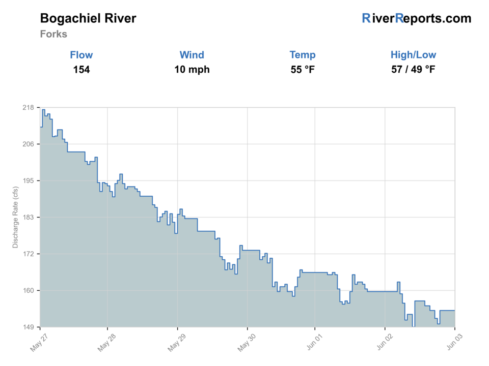
USGS data chart
Official USGS trend
Streamflow over the latest USGS reporting window.
Weather
River weather report
Weather can change wading safety, road access, water temperature, hatches, and the best time of day to fish.
Live forecast loads as you reach this section
This keeps the report fast while still using the official National Weather Service forecast point.
Hatches and flies
Hatch chart and fly picks
Winter
Sparse midges, stonefly nymph activity, egg windows around salmon and steelhead water
Black or purple intruder, marabou tube, egg pattern, stonefly nymph
Spring
Skwala-style stoneflies, March browns, caddis, streamer windows in dropping flow
Stonefly nymph, olive bugger, soft hackle, March brown dry
Summer
Caddis, small mayflies, terrestrials on softer edges and side channels
Elk hair caddis, parachute Adams, beetle, hopper-dropper, beadhead nymph
Fall
Caddis, October caddis, eggs, and baitfish-style streamer windows around salmon traffic
October caddis dry, egg pattern, flesh fly, sculpin streamer
Swing flies
Black-and-blue intruder, purple marabou, sparse leech, traditional hairwing
Use in winter and spring steelhead windows when flows are green enough to swing slower edges and tailouts.
Trout and cutthroat dries
Elk hair caddis, parachute Adams, stimulator, foam beetle
Best in summer and early fall when lower water opens softer seams, pocket edges, and side channels.
Nymphs and indicators
Stonefly nymph, perdigon, hare's ear, egg, caddis pupa
Useful when the river is cold, slightly colored, or too pushy for an efficient swing-only approach.
Tactics
How to fish it
Start from a named public entry and fish one corridor thoroughly instead of bouncing from pull-off to pull-off.
On dropping winter flow, cover soft tailouts, ledge edges, and inside seams before stepping into heavier water.
In clear summer water, shorten the day, use lighter flies, and work lower-river cutthroat water with more stealth.
When the river is rising, keep both boots and expectations on the bank.
Rigging
Rod, leader, and setup notes
A 6- or 7-weight single hand rod is enough for many Bogachiel days, while a short two-hander helps on broader winter swings.
Carry sink tips, a floating line, and a dry bag because conditions can move from soft swing water to bank-hugging flows in one storm cycle.
Bring 0X through 4X tippet so you can switch between steelhead and summer cutthroat styles without overcomplicating the kit.
Access
Access and planning notes
La Push gauge
Primary coastal-river trendWade / float / trail
RiverReports / USGS gauge / steelhead
When to pick it
Start here when rain, color, and broad gravel-bar safety decide the day.
Caution
The gauge does not replace WDFW emergency rules, park rules, or access-boundary checks.
Bogachiel State Park
Cleanest public bank anchorWade / float / trail
State park / bank / wade
When to pick it
Use it when you want a source-backed public start near Forks.
Caution
Wet banks, wood, crowds, and changing gravel still require conservative wading.
Bogachiel Rain Forest trailhead
Forest trail accessWade / float / trail
Forest trail / bank / wade
When to pick it
Pick it when flow and weather support a walk-in river check before park-boundary rules change.
Caution
Confirm trail conditions, forest alerts, and Olympic National Park boundary details.
Do not assume every roadside opening is a legal entry or safe turnaround during wet weather.
Public access near Forks is easier than on some nearby rivers, but wood, soft banks, and changing gravel still demand caution.
Inside Olympic National Park, park-specific fishing rules replace generic statewide assumptions.
Regulations
Check before fishing
Check Washington sport fishing rules, current emergency rule changes, and Olympic National Park regulations before fishing the Bogachiel, especially for steelhead, salmon, selective-gear requirements, and park-boundary reach changes.
Primary base
Forks, Bogachiel State Park, and lower public access near Highway 101
Best day style
State-park pull-ins, forest trail access, and lower-river gravel bars that change with rain
Check first
Washington rules, emergency updates, the 12043015 trend, recent rain, and whether your entry point is clearly public
Safety
Fast rain rises, wood, slick cobble, soft banks, and overconfidence on broad gravel bars
Gear
Helpful gear for this water
6- to 8-weight rod
A 7-weight is the best all-around Olympic Peninsula choice when steelhead, salmon, and large trout water all matter.
Wading staff and studded traction
These rivers are slick, pushy, and log-strewn even when the banks look flat.
Rain shell and dry layers
Weather swings and rainforest humidity can turn a comfortable day into a cold one quickly.
Rubber net and quick release tools
Protected wild fish, char encounters, and selective-gear rules make fast in-water handling the right default.
Nearby water
Other water to research
Backup logic
High brown water
Compare Hoh or Quinault only if they are falling and legally open; otherwise wait.
Emergency rule issue
Choose a legally open Washington route before choosing flies.
Soft banks or wood hazard
Stay bank-first at a public anchor or move to a safer river.
Crowded green window
Shift timing, use a different public anchor, or compare Sauk River.
Hoh River
A larger nearby rainforest river that usually needs the same rain-driven caution.
Quinault River
Another west-side option when you want a bigger valley and broader access network.
Sauk River
A more rule-sensitive North Cascades alternative when coastal rivers are blown out.
FAQ
Fast answers
Is Bogachiel River fishable today?
Bogachiel River looks very fishable right now. The live score is 96/100, based on current flow, weather, public alerts, and the report's planning context. Recheck the linked gauge and forecast before leaving because conditions can change quickly after rain, heat, access changes, or flow swings.
What flow is best for Bogachiel River?
Use the La Push gauge with recent rain and color. Green, stable, or dropping water is the best Bogachiel signal.
When should I skip Bogachiel River?
Skip when WDFW emergency rules or park rules do not support the plan, the river is high and brown, wood or soft banks are unsafe, or broad gravel bars are rising.
Is Bogachiel River safe to wade right now?
The fishability score is not a wading guarantee. Wade only where your chosen access has safe edges, clear footing, legal entry, and no forced crossings; high, rising, stained, or storm-affected water should be treated conservatively.
What gauge should I check for the Bogachiel River?
Start with RiverReports for the fast chart view and keep USGS 12043015 open as the official backup when you judge whether rain has pushed the river too high to wade safely.
Is the Bogachiel mostly a steelhead river?
That is the main planning identity for many anglers, but only when the current Washington rules support it. Outside those windows, the Bogachiel is better treated as a scouting or lighter cutthroat-style river.
Where should I start for public access?
Bogachiel State Park and the Bogachiel Rain Forest trailhead are the cleanest starting points because they provide obvious public access without guessing at roadside ownership.
Sources
Source set for this report
Reviewed 2026-06-02