
Washington / Pacific Northwest
Calawah River
A Calawah report for Forks-area planning with live flow checks, public-land orientation, and realistic winter steelhead and summer trout judgment.
Image: Generated Washington planning image for Calawah River / BlueStreamFly generated; not exact location / BlueStreamFlyFishability now: Calawah River fishability today
GreatData confidence: High96/100
Fishable now because the live gauge is stable, weather is mild, and no public alert is active.
Flow observed
3:30 PM UTC
Weather observed
4:00 PM UTC
Score calculated
4:20 PM UTC
Why this rating
Flow
Water temperature
Public alerts
Next 6-12 hours
Hold
Stable live data supports staying with the plan, but recheck the gauge and forecast before leaving.
USGS flow
158 cfs
Current trend: flow stable, so weather, temperature, and access checks drive the next change.
More planning details: flies, flow bands, and live source checks
Fish it today
Start here
Start with WDFW rules and the Calawah gauge, then choose a Forks-area public pull-in, North Fork corridor, or lower gravel-bar check by water color.
Best flow clue
Use the Forks gauge with recent rain. Green and dropping flow is the best Calawah signal.
Skip trigger
Skip when WDFW rules are closed or unclear, water is high and colored, gravel bars are changing, wood is moving, or access depends on private banks.
Flow decision bands
Green dropping flow
A dropping USGS Forks trend with green water is the best all-around steelhead signal.
Best public-entry window
Current legal openings, stable rain pattern, readable gravel bars, and clear public entry make the river most useful.
High colored water
High, brown, or still-rising water should move the plan to scouting or another route.
Private-bank or gravel-bar risk
Unclear bank access, moving wood, changing bars, or soft edges can override fishable color.
USGS flow
158 cfs
Current trend: flow stable, so weather, temperature, and access checks drive the next change.
Live USGS flow
158 cfs / stable
Live NWS forecast
55F / Mostly Cloudy
Live water temperature
57F from USGS
No NWS alert flag
No active NWS alert was returned for this forecast point.
Recent rain can push the Calawah out of shape quickly, and the river often fishes best after the biggest color starts to leave.
The Olympic National Forest Forks-area guidance is the best public-land orientation source for the North Fork corridor.
A clean gravel bar is not proof of public access on every reach, so road-end discipline matters.
Summer and early fall are lower-pressure windows for lighter trout and cutthroat-style fishing when flows stay cool enough.
Editorial review
How this report is maintained
This report starts with official regulation, access, flow, weather, and public-land sources, then adds practical planning guidance for fly anglers.
Byline
BlueStreamFly editorial desk
Reviewed by
BlueStreamFly source review
Maintained by
BlueStreamFly
Last material review
2026-06-02
Report confidence
Good confidence
86/100
Good confidence: RiverReports, USGS Forks flow, Washington regulations and emergency rules, WDFW coastal steelhead context, Olympic National Forest access context, weather coverage, image disclosure, and route-specific rain-window guidance support the page. Confidence is moderated by emergency rule volatility, private-bank uncertainty, rain spikes, changing gravel bars, wood, and color timing.
Regulations
Washington sport-fishing rules, emergency rule changes, and coastal steelhead context support the legal-check path.
Access
Olympic National Forest Forks-area context supports public-land orientation, but exact banks and pull-ins still require local confirmation.
Flow and weather
RiverReports coverage is backed by USGS 12043000 near Forks, and the National Weather Service point supports rain, storm, and safety decisions.
Fishing usefulness
The page now separates Forks flow, green-dropping timing, WDFW rule checks, public pull-ins, private-bank risk, gravel-bar safety, and backup-water choices.
Fishability dashboard and source review
2026-06-02 / material content or source review
RiverReports, USGS 12043000 near Forks, Washington sport-fishing regulations, WDFW emergency rule changes, WDFW coastal steelhead management, Olympic National Forest Forks-area access context, National Weather Service data, and image-disclosure sources were checked before updating the current-fishability decision layer.
2026-06-02
Updated Calawah River to the current fishability-page standard with Forks trend bands, forest-road and gravel-bar access cards, rain-color and emergency-rule skip cues, backup logic, stable fishability SEO, and confidence signals.
2026-05-28
Published a new Calawah River report with flow guidance, Forks-area access anchors, and conservative steelhead-season planning notes.
Angler planning edge
Local details that change the plan
Best for
winter steelhead, Forks-area rain-window timing, coho and cutthroat context
Wade or float
Bank and wade conservatively from clearly public Forks-area entries; treat floats and private banks as access-sensitive, not automatic.
Best flows
Use the Forks gauge with recent rain. Green and dropping flow is the best Calawah signal.
When to skip
Skip when WDFW rules are closed or unclear, water is high and colored, gravel bars are changing, wood is moving, or access depends on private banks.
Local plan
Start with WDFW rules and the Calawah gauge, then choose a Forks-area public pull-in, North Fork corridor, or lower gravel-bar check by water color.
Pressure
Steelhead pressure rises fast when a green window opens near Forks.
Access nuance
Olympic National Forest access context helps, but every bank beyond obvious public entries needs private-land discipline.
Backup water
Compare Bogachiel, Hoh, or Quinault when the Calawah is too high, too colored, closed, crowded, or access-uncertain.
About the river
Setting, character, and why it fishes the way it does.
The Calawah is part of the broader Quillayute country near Forks, but it fishes differently enough that it deserves its own planning page. It is smaller and often clearer than some neighboring rivers, which makes timing and presentation matter more.
Official public-land information is thinner here than on the park-heavy Olympic destination rivers, so the responsible approach is to anchor on the forest-access corridor and avoid casual assumptions about every roadside bank.
For BlueStreamFly readers, the useful way to think about the Calawah is as a decision river: it is either green enough to fish confidently, or it is a move-to-something-else day.
Target species
Winter steelhead
The headline draw when flows are green enough and current regulations keep the fishery open.
Coho salmon
Part of the fall river context even when your fly plan stays focused on steelhead-ready water.
Cutthroat trout
More relevant in lower, clearer seasonal windows when lighter flies make more sense.
Whitefish
A realistic cold-season backup target when bigger migratory fish are not cooperating.
Reading the water
High colored water
Usually a pass unless you know a very specific inside edge and can wade safely.
Green dropping flow
The best all-around steelhead window for swung flies or controlled indicator work.
Low summer flow
Shrink the river and fish pocket water, seams, and softer tailouts with smaller flies.
Sharp overnight rise
Assume the bars and edges changed and reset the access plan before stepping in.
Best seasons
Winter
Primary steelhead season when rain timing, not just calendar date, decides the quality of the day.
Spring
Useful if flows are dropping and the river keeps enough green color to move fish.
Summer
A lower-pressure small-fly window rather than a classic big-river steelhead trip.
Fall
Good for scouting the system and fishing lighter water when regulations and conditions line up.
Preferred flow source
Calawah River near Forks
RiverReports is the preferred chart source when coverage exists. When a matching USGS gauge exists, keep it open as the official backstop for station data and current hydrograph context.
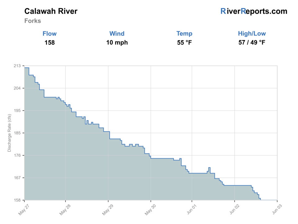
USGS data chart
Official USGS trend
Streamflow over the latest USGS reporting window.
Latest
158 cfs
Jun 3, 4 PM UTC
Weather
River weather report
Weather can change wading safety, road access, water temperature, hatches, and the best time of day to fish.
Live forecast loads as you reach this section
This keeps the report fast while still using the official National Weather Service forecast point.
Hatches and flies
Hatch chart and fly picks
Winter
Sparse midges, stonefly nymphs, and egg windows around steelhead or salmon traffic
Black intruder, purple marabou, egg pattern, stonefly nymph
Spring
March browns, caddis, and dropping-flow streamer windows
Soft hackle, olive bugger, stonefly nymph, March Brown dry
Summer
Caddis, small mayflies, and terrestrials around softer edges
Elk hair caddis, beetle, parachute Adams, hopper-dropper
Fall
October caddis, eggs, and baitfish-style streamer windows
October caddis, egg pattern, flesh fly, sculpin streamer
Swing flies
Black-and-blue intruder, purple leech, sparse marabou, hairwing
Best in green winter water when you can cover tailouts and walking-speed seams cleanly.
Indicator and nymph rigs
Stonefly nymph, perdigon, egg, caddis pupa
Useful when the river is cold, slightly colored, or too pushy for a clean swing.
Summer dries and light trout flies
Elk hair caddis, parachute Adams, foam beetle, small stimulator
Helpful when summer levels shrink the river into pocket water and side-channel edges.
Tactics
How to fish it
On winter days, cover the softer walking-speed seams thoroughly instead of racing from bar to bar.
When the river drops into summer shape, downsize the fly and fish pocket-water edges rather than forcing big steelhead presentations.
If color is still heavy after rain, fish only where you can see structure and step out safely.
Use the Calawah as part of a Forks-area rotation instead of making it the only option on a weather-sensitive trip.
Rigging
Rod, leader, and setup notes
A Skagit-style setup or short sink-tip system covers the winter plan cleanly when flows are green and pushy.
Carry an indicator rig with a stonefly or egg-style support fly for deeper buckets and slow insides.
Switch to a floating line and lighter leader in lower summer water where cutthroat-style presentations matter more.
Access
Access and planning notes
Forks gauge
Primary rain-window trendWade / float / trail
RiverReports / USGS gauge / steelhead
When to pick it
Start here when color, height, and recent rain decide whether the river is worth a look.
Caution
The gauge does not replace WDFW emergency rules or public-entry checks.
Forks-area public pull-ins
Conservative first lookWade / float / trail
Public pull-in / bank / wade
When to pick it
Use these to inspect height, color, and gravel before committing.
Caution
Do not turn a visible gravel bar into a private-bank roam.
North Fork Calawah corridor
Forest-based access contextWade / float / trail
Forest road / bank / wade
When to pick it
Pick it when forest access, weather, and flow all support a public-land plan.
Caution
Confirm roads, signs, and weather; fresh rain can change the hike back.
Use the Olympic National Forest Forks-area page as the first public-land access reference.
Treat every bank beyond obvious public entries as private unless clearly signed or mapped otherwise.
Fresh rain can erase the easy-looking path back across a gravel bar by the time you hike out.
Regulations
Check before fishing
Check Washington sport fishing rules and current emergency changes before fishing because steelhead and salmon windows on coastal rivers can change faster than old forum posts suggest.
Primary base
Forks, Washington
Best day style
Forest-road pull-ins, broad gravel bars, and public-land entries that still demand private-land discipline
Check first
Washington rules, emergency changes, the 12043000 trend, recent rain, and whether your chosen bar or bank is clearly public
Safety
Fast rain rises, shifting gravel bars, wood, slick cobble, and poor visibility in colored water
Gear
Helpful gear for this water
6- to 8-weight rod
A 7-weight is the safe all-around choice when steelhead, salmon, and larger river current all matter.
Studded boots and wading staff
These rivers stay slick and pushy even when the banks or bars make them look friendlier.
Rain shell and dry layers
Washington weather can flip from comfortable to hypothermia territory faster than many inland anglers expect.
Compact pliers and rubber net
A better default for selective-gear handling and quick releases around protected wild fish.
Nearby water
Other water to research
Backup logic
High colored water
Compare Bogachiel or Hoh only if they are falling and legally open.
Emergency rule issue
Choose another legally open Washington route before choosing flies.
Unclear public access
Stay at obvious public entries or move to Bogachiel State Park-style access.
Changing gravel or wood
Stay bank-first, scout only, or wait for a safer flow.
Bogachiel River
A nearby system with a broader public-water identity and another good Forks fallback.
Hoh River
A larger Olympic option when you want more room and are ready for a bigger river.
Quinault River
A broader valley plan when west-side weather lines up farther south.
FAQ
Fast answers
Is Calawah River fishable today?
Calawah River looks very fishable right now. The live score is 96/100, based on current flow, weather, public alerts, and the report's planning context. Recheck the linked gauge and forecast before leaving because conditions can change quickly after rain, heat, access changes, or flow swings.
What flow is best for Calawah River?
Use the Forks gauge with recent rain. Green and dropping flow is the best Calawah signal.
When should I skip Calawah River?
Skip when WDFW rules are closed or unclear, water is high and colored, gravel bars are changing, wood is moving, or access depends on private banks.
Is Calawah River safe to wade right now?
The fishability score is not a wading guarantee. Wade only where your chosen access has safe edges, clear footing, legal entry, and no forced crossings; high, rising, stained, or storm-affected water should be treated conservatively.
When is the Calawah River worth fishing?
Usually when the river is green and dropping after rain. If it is still muddy or climbing, the better move is often to wait or switch rivers.
Is the Calawah mostly a bank-fishing or boat river?
Most visiting fly anglers treat it as a careful bank-and-bar planning river. Access and safety matter more than squeezing in extra casts.
What should I check before fishing the Calawah?
Check RiverReports, USGS 12043000, current Washington rules, emergency updates, and whether your planned stop is clearly public.
Sources
Source set for this report
Reviewed 2026-06-02