Utah / West
Weber River
A Weber River report for the upper river and Oakley/Echo flow context, with access-law cautions, hatches, flies, and planning notes.
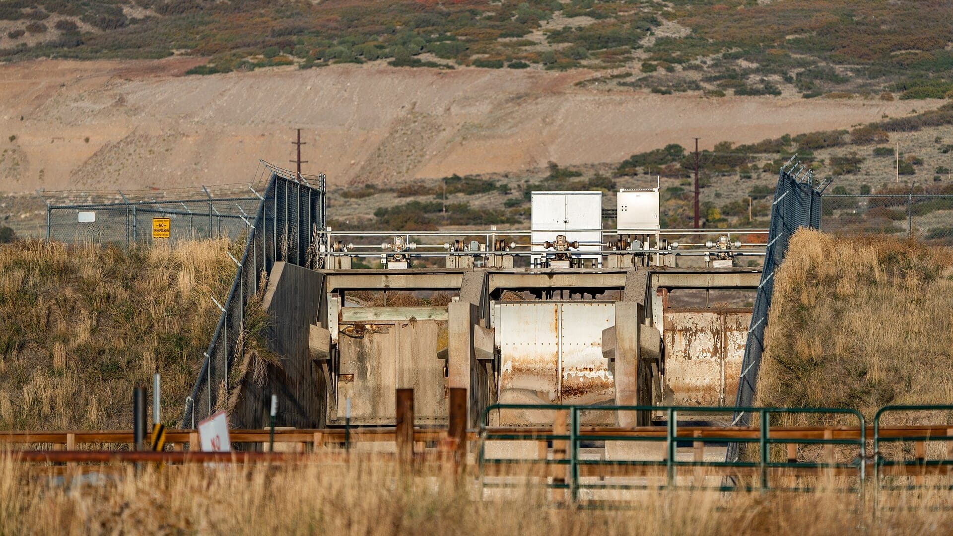
Image: Willard Bay Reservoir - Weber River Dam - Willard - Utah / CC BY 2.0 / Tony WebsterFishability now: Weber River fishability today
GreatData confidence: High96/100
Fishable now because the live gauge is stable, weather is mild, and no public alert is active.
Flow observed
4:15 PM UTC
Weather observed
5:00 PM UTC
Score calculated
5:23 PM UTC
Why this rating
Flow
Weather
Public alerts
Next 6-12 hours
Hold
Stable live data supports staying with the plan, but recheck the gauge and forecast before leaving.
USGS flow
381 cfs
Current trend: flow stable, so weather, temperature, and access checks drive the next change.
More planning details: flies, flow bands, and live source checks
Fish it today
Start here
Start with the access corridor. Oakley gives the clearest flow match for this page, Holiday Park to Echo demands careful stream-access checks, and downstream water should be treated as a separate planning problem.
Best flow clue
Use RiverReports and USGS 10128500 near Oakley as the upper-river trend. Stable post-runoff flows are the best fit, while storm spikes, irrigation swings, reservoir influence, or very low warm water should narrow the plan quickly.
Skip trigger
Skip the Weber when legal access is uncertain, when high water would force risky crossings, when ice or warm-water stress controls the day, or when you need a simpler public-access river.
Flow decision bands
Stable upper-river flow
Stable or slowly falling Oakley flow after runoff is the best signal for dry-dropper, stonefly nymph, caddis, PMD, and terrestrial work.
Best access-first window
A fishable gauge, confirmed legal access, mild weather, and cool enough trout water make the Weber strongest.
High, icy, or low warm water
Storm spikes, risky crossings, shelf ice, irrigation swings, or very low warm water should narrow or cancel the plan.
Boundary-sensitive
Posted signs, reservoir influence, upper-versus-lower reach differences, and private-boundary uncertainty can matter more than the fly box.
USGS flow
381 cfs
Current trend: flow stable, so weather, temperature, and access checks drive the next change.
Live USGS flow
381 cfs / stable
Live NWS forecast
69F / Mostly Sunny
Water temperature not verified
Heat guidance uses weather and river type unless an official water-temperature value is available.
No NWS alert flag
No active NWS alert was returned for this forecast point.
Check Utah DWR stream access guidance before walking the bed or banks.
Use RiverReports and USGS Oakley flow to understand upper Weber conditions.
Post-runoff caddis, PMDs, stones, terrestrials, and small nymphs are the core trout plan.
If the access question is unclear, choose a different public reach instead of guessing.
Editorial review
How this report is maintained
This report is maintained from current regulation, access, flow, weather, and public planning sources so anglers can make better trip decisions than a raw gauge or generic overview would allow.
Byline
BlueStreamFly editorial team
Reviewed by
BlueStreamFly source review
Maintained by
Mountain Brook Run LLC
Last material review
2026-06-01
Report confidence
Good confidence
89/100
Good confidence: Utah regulation, stream-access, Fish Utah, RiverReports plus USGS Oakley flow, weather coverage, image credit, and route-specific access-first guidance support the page. Confidence is moderated by access complexity, reservoir and irrigation influence, upper-versus-lower reach differences, pressure, and temperature.
Regulations
Utah DWR fishing and guidebook sources support the current rule-check path for Weber River trips.
Access
Stream-access and Fish Utah sources support the public framework, but the Weber's public-access context remains the main thing to verify before fishing.
Flow and weather
RiverReports coverage is backed by USGS 10128500 near Oakley, and the National Weather Service point supports live flow, weather, and safety decisions.
Fishing usefulness
The page now separates access-first planning, upper-river flow context, reservoir and irrigation influence, skip cues, pressure, and backup-water choices.
Fishability dashboard and source review
2026-06-01 / material content or source review
Utah DWR fishing, guidebook, stream-access, and Fish Utah sources, RiverReports and USGS Oakley flow support, National Weather Service data, and the Weber media credit were checked before updating the current-fishability decision layer.
2026-06-01
Updated Weber River to the current fishability-page standard with Oakley flow bands, access-first section cards, backup cues, stable fishability SEO, and confidence signals.
2026-05-28
Added Weber-specific trip-fit guidance, wade-first planning, Oakley trend framing, stream-access nuance, pressure timing, backup-water suggestions, editorial review signals, and a page-specific report-confidence meter after source checks.
2026-05-25
Initial source-reviewed report published with flows, weather, hatches, flies, tactics, access, regulations, and FAQs.
Angler planning edge
Local details that change the plan
Best for
Anglers who want a Utah trout day but are willing to solve access before fishing, Upper Weber plans that use the Oakley gauge trend rather than downstream city assumptions, Post-runoff dry-dropper, stonefly-nymph, caddis, PMD, and terrestrial fishing, Shorter Wasatch-region sessions where legal access and water temperature decide the plan
Wade or float
Treat the Weber as a wade-first trout report. The useful plan is to choose clearly legal public water and fish it on foot; access questions should be resolved before any broader mileage plan.
Best flows
Use RiverReports and USGS 10128500 near Oakley as the upper-river trend. Stable post-runoff flows are the best fit, while storm spikes, irrigation swings, reservoir influence, or very low warm water should narrow the plan quickly.
When to skip
Skip the Weber when legal access is uncertain, when high water would force risky crossings, when ice or warm-water stress controls the day, or when you need a simpler public-access river.
Local plan
Start with the access corridor. Oakley gives the clearest flow match for this page, Holiday Park to Echo demands careful stream-access checks, and downstream water should be treated as a separate planning problem.
Pressure
The Weber can feel quiet compared with the Provo, but obvious public corridors and bridge-area water still concentrate anglers during the best post-runoff and fall windows.
Access nuance
This is one of the Utah pages where access nuance is central. Use Utah DWR stream-access guidance, Fish Utah, posted signs, and obvious public corridors rather than assuming the streambed or banks are open everywhere.
Backup water
If the Weber access or flow plan is not clean, compare the Provo for a technical Wasatch day, the Green for a clearer tailwater objective, or the Duchesne for a freestone alternative.
About the river
Setting, character, and why it fishes the way it does.
The Weber River drains northern Utah mountain country before moving through reservoirs, towns, and valley corridors. It has trout water, but the access picture can be more complicated than the fishing.
Utah DWR specifically calls out Weber River access context, including differences on parts of the upper Weber. That makes a source-driven page more useful than broad fishing shortcuts.
This page uses the Oakley RiverReports and USGS gauge as the primary flow anchor because it matches the seeded report topic better than a downstream city-only gauge.
Target species
Brown trout
A common river target around banks, deeper bends, and undercut structure.
Rainbow trout
Present in managed reaches; verify current DWR and Fish Utah information.
Cutthroat trout
Relevant in upper basin context; handle carefully and verify reach-specific rules.
Mountain whitefish
Can be part of the nymphing picture in colder months.
Reading the water
Runoff or high water
Avoid crossings and focus on safer public edges or another water.
Post-runoff
Fish dry-droppers, stonefly nymphs, caddis, and PMDs through pocket water.
Low clear water
Use smaller flies, longer leaders, and avoid repeated wading through holding water.
Winter
Pick mild stable days and watch icy banks.
Best seasons
Spring
Pre-runoff can fish, but snowmelt may change flows quickly.
Summer
Post-runoff trout fishing and terrestrials can be good when water stays cool.
Fall
Lower crowds, clear water, BWOs, and streamer windows improve.
Winter
Slow nymphing is possible on mild days with safe access.
Preferred flow source
Weber River near Oakley
RiverReports is the preferred chart source when coverage exists. When a matching USGS gauge exists, keep it open as the official backstop for station data and current hydrograph context.
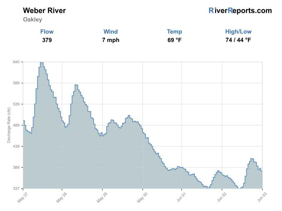
USGS data chart
Official USGS trend
Streamflow over the latest USGS reporting window.
Latest
381 cfs
Jun 3, 4 PM UTC
Weather
River weather report
Weather can change wading safety, road access, water temperature, hatches, and the best time of day to fish.
Live forecast loads as you reach this section
This keeps the report fast while still using the official National Weather Service forecast point.
Hatches and flies
Hatch chart and fly picks
April to May
Pre-runoff midges, BWOs, early caddis, and nymph windows
BWO emerger, zebra midge, caddis pupa, pheasant tail, perdigon
June to July
Post-runoff caddis, PMDs, golden stones, drakes where present, and attractors
Chubby Chernobyl, PMD, caddis dry, stonefly nymph, hare's ear
August to September
Terrestrials, ants, beetles, hoppers, evening caddis, and low-water nymphs
Hopper, foam ant, beetle, elk hair caddis, perdigon, small streamer
October to March
BWOs, midges, small stones, and slow winter nymphing
BWO emerger, zebra midge, stonefly nymph, midge pupa, leech
Nymphs
Perdigon, pheasant tail, hare's ear, zebra midge, caddis pupa, stonefly
Use before hatches, in pocket water, or when trout hold near the bottom.
Dries and dry-droppers
Parachute Adams, BWO, caddis, sulphur, ant, beetle, hopper, stimulator
Use during visible rises, pocket-water searching, and low clear water.
Streamers
Sculpin, olive bugger, black bugger, leech, small baitfish
Use after rain, in stained water, and around undercut banks or boulders.
Tactics
How to fish it
Confirm legal access before choosing a run.
Fish dry-droppers around riffles, banks, and pocket water after runoff.
Use smaller nymphs and light tippet in low clear water.
Try streamers near undercut banks and deeper bends during low light.
Use the Fish Utah map and local signage to avoid private-land problems.
Rigging
Rod, leader, and setup notes
A 9-foot 4 or 5-weight covers most Weber trout fishing.
Carry 4X to 6X and a mix of attractor dries, caddis, PMDs, and small nymphs.
Bring heavier nymphs for post-runoff pocket water.
Wading staff and good traction help on uneven freestone bottom.
Access
Access and planning notes
Oakley gauge
Primary upper-river trendWade / float / trail
RiverReports / USGS gauge / wade
When to pick it
Start here because it matches the upper Weber planning scope better than a downstream city-only assumption.
Caution
The gauge does not settle access, reservoir influence, or irrigation-driven reach differences.
Oakley and upper Weber corridors
Clearest flow matchWade / float / trail
Wade / bank / access
When to pick it
Use this when flow, access, and temperature support a focused upper-river trout plan.
Caution
Confirm posted signs, public corridors, and private boundaries before fishing.
Holiday Park to Echo context
Access-sensitive comparisonWade / float / trail
Wade / scout / access
When to pick it
Pick this only after stream-access context and exact legal entry are clear.
Caution
This is not a place to assume every bank or streambed is open.
The Weber has special stream-access sensitivity; check current DWR guidance.
Private property and posted land must be respected.
Irrigation and reservoir operations can affect flows and wading.
Regulations
Check before fishing
Check the Utah DWR guidebook, Fish Utah, stream access guidance, and current emergency changes before fishing the Weber.
Primary base
Oakley, Kamas, Coalville, or Ogden area
Best day style
Utah trout river with stream-access complexity, public corridors, private land, and pressured reaches
Check first
Utah stream access guidance, RiverReports/USGS flow, DWR rules, weather, and temperature
Safety
Private land, changing access law context, irrigation flows, slick rocks, and winter ice
Gear
Helpful gear for this water
Four or five-weight rod
Covers most dry-fly, nymph, and dry-dropper work.
Six-weight or streamer rod
Useful for wind, higher water, and larger flies.
Thermometer
Use it before catch-and-release trout fishing in warm weather.
Wading staff
Helpful on freestone rocks, tailwater ledges, and pushy runs.
Barbless-hook box
Speeds handling on wild trout and special-regulation water.
Nearby water
Other water to research
Backup logic
Access uncertainty
Compare Provo River, Green River, or Duchesne River instead of guessing at boundaries.
High or changing water
Wait for the flow to settle or choose a tailwater with clearer release context.
Warm trout water
Fish only the coolest responsible window or pick a colder option.
Crowded public corridors
Shift timing, use a confirmed secondary access, or choose another Utah trout river.
Provo River
A technical Wasatch trout river with heavy pressure.
Green River
A clear canyon tailwater below Flaming Gorge.
Duchesne River
A Uinta freestone plan with access and runoff checks.
FAQ
Fast answers
Is Weber River fishable today?
Weber River looks very fishable right now. The live score is 96/100, based on current flow, weather, public alerts, and the report's planning context. Recheck the linked gauge and forecast before leaving because conditions can change quickly after rain, heat, access changes, or flow swings.
What flow is best for Weber River?
Use RiverReports and USGS 10128500 near Oakley as the upper-river trend. Stable post-runoff flows are the best fit, while storm spikes, irrigation swings, reservoir influence, or very low warm water should narrow the plan quickly.
When should I skip Weber River?
Skip the Weber when legal access is uncertain, when high water would force risky crossings, when ice or warm-water stress controls the day, or when you need a simpler public-access river.
Is Weber River safe to wade right now?
The fishability score is not a wading guarantee. Wade only where your chosen access has safe edges, clear footing, legal entry, and no forced crossings; high, rising, stained, or storm-affected water should be treated conservatively.
What should I check first before fishing Weber River?
Check Utah stream access guidance, DWR rules, RiverReports or USGS 10128500, weather, and temperature.
Where should a first-time visitor start on Weber River?
Start with clearly public access near the upper Weber or agency-managed corridors after checking Fish Utah and signs.
Can I wade Weber River?
Yes in some public reaches at safe flows, but legal access and private property are the main constraints.
What flies should I bring for Weber River?
Bring the seasonal fly box, then adjust size, weight, and color to the water level, clarity, temperature, and fishing pressure you find.
Sources
Source set for this report
Reviewed 2026-06-01