
Utah / Rockies
Fremont River
A Fremont River report for anglers planning the Bicknell Bottoms to Capitol Reef corridor with live flow checks, walk-in access, and desert-river caution.
Image: Generated regional planning image for Fremont River / BlueStreamFly generated; not exact location / BlueStreamFlyFishability now: Fremont River fishability today
GreatData confidence: High96/100
Fishable now because the live gauge is stable, weather is usable, and no public alert is active.
Flow observed
4:45 PM UTC
Weather observed
5:00 PM UTC
Score calculated
5:23 PM UTC
Why this rating
Flow
Weather
Public alerts
Next 6-12 hours
Hold
Stable live data supports staying with the plan, but recheck the gauge and forecast before leaving.
USGS flow
51 cfs
Current trend: flow stable, so weather, temperature, and access checks drive the next change.
More planning details: flies, flow bands, and live source checks
Fish it today
Start here
Base in Torrey or Bicknell, choose either Bicknell Bottoms or a short upper Capitol Reef corridor stop, fish one section carefully, and leave once clarity or temperature drops below the line.
Best flow clue
Fish best on stable moderate flow that keeps Bicknell channels connected and the upper corridor clear enough to read without turning every step into a mud-and-brush problem.
Skip trigger
Skip when the water is muddy, warm, or obviously degraded at the access point, when storms are pushing desert runoff, or when the only plan depends on unverified private-land frontage.
Flow decision bands
Stable Bicknell flow
Stable or slowly falling 09330000 flow with clear channels is the best short-session signal.
Public corridor first
Choose Bicknell Bottoms or a focused upper Capitol Reef stop before treating the valley as open water.
Storm mud or water quality
Dirty runoff, E. coli concern, or long soak-style wading in the park should end the trout plan.
Warm desert low water
Warm low flow should shorten the day or move the plan to another Utah trout river.
USGS flow
51 cfs
Current trend: flow stable, so weather, temperature, and access checks drive the next change.
Live USGS flow
51 cfs / stable
Live NWS forecast
74F / Mostly Sunny
Water temperature not verified
Heat guidance uses weather and river type unless an official water-temperature value is available.
No NWS alert flag
No active NWS alert was returned for this forecast point.
The Utah Fishing Guidebook says Bicknell Bottoms is open to fishing except where posted closed, and specifically identifies the area as being along the Fremont River.
The Bicknell Bottoms habitat plan says access is walk-in only and often requires waders, which is a practical warning against treating the reach like casual roadside bank water.
Capitol Reef notes that upstream reaches of Fruita in the Fremont gorge support brown trout, while the lower reaches through Fruita and downstream do not support a sport fishery in the same way.
Capitol Reef also warns against swimming or long wading in the Fremont River because E. coli is routinely detected above Utah water-quality standards, so long soak-style park wading is the wrong default.
Editorial review
How this report is maintained
This report starts with official regulation, access, flow, weather, and public-water sources, then adds practical planning guidance for fly anglers.
Byline
BlueStreamFly editorial desk
Reviewed by
BlueStreamFly source review
Maintained by
BlueStreamFly
Last material review
2026-06-02
Report confidence
Good confidence
86/100
Good confidence: Utah guidebook, WMA access sources, Capitol Reef fishery and access context, RiverReports and USGS 09330000 flow, weather coverage, generated media disclosure, and route-specific Fremont guidance support the page. Confidence is moderated by desert runoff, water quality, private-land access, small public corridors, and heat.
Regulations
Utah guidebook and site-posting references support the current legal-check path.
Access
Bicknell Bottoms and Capitol Reef sources support the planning corridor, with exact postings, private land, and walk-in conditions still requiring current checks.
Flow and weather
RiverReports, USGS 09330000 near Bicknell, and the National Weather Service point support live flow and weather decisions.
Fishing usefulness
The page now separates desert-river flow, WMA access, upper park context, water-quality limits, heat restraint, and backup-water choices.
Fishability dashboard and source review
2026-06-02 / material content or source review
Utah fishing guidebook sources, Bicknell Bottoms WMA access sources, Capitol Reef fishery, road, campground, and water-quality context, RiverReports and USGS 09330000 flow, National Weather Service data, and generated-image disclosure were checked before updating the current-fishability decision layer.
2026-06-02
Updated Fremont River to the current fishability-page standard with desert-river flow bands, Bicknell Bottoms and Capitol Reef access cards, backup cues, stable fishability SEO, and confidence signals.
2026-05-27
Published a new Fremont River report with Bicknell Bottoms public-access framing, Capitol Reef fishery limits, and desert-river safety guidance.
Angler planning edge
Local details that change the plan
Best for
Short trout sessions tied to one verified public corridor, Anglers already visiting Capitol Reef or Wayne County who want a focused side trip, Spring and fall days when the river still has clarity and a real trout window
Wade or float
This is a wade-first and walk-in-first page. Floating is not the main Fremont plan here, and the strongest public access is built around deliberate on-foot fishing.
Best flows
Fish best on stable moderate flow that keeps Bicknell channels connected and the upper corridor clear enough to read without turning every step into a mud-and-brush problem.
When to skip
Skip when the water is muddy, warm, or obviously degraded at the access point, when storms are pushing desert runoff, or when the only plan depends on unverified private-land frontage.
Local plan
Base in Torrey or Bicknell, choose either Bicknell Bottoms or a short upper Capitol Reef corridor stop, fish one section carefully, and leave once clarity or temperature drops below the line.
Pressure
Pressure is usually lighter than on Utah's famous tailwaters, but the useful public water is smaller than the map suggests, so even a few anglers can crowd the best seams.
Access nuance
The Fremont looks open from roads and viewpoints, but the trustworthy public-fishing signal comes from Bicknell Bottoms and short clearly public park corridors, not from assuming the whole valley is open.
Backup water
Green River is the better backup for a premium trout day, while Duchesne River makes more sense when you still want moving Utah trout water without forcing a marginal desert-river call.
About the river
Setting, character, and why it fishes the way it does.
The Fremont River is one of Utah's most visually striking trout-planning waters because it runs from mountain country into red-rock desert. That beauty can fool anglers into thinking the whole corridor fishes the same way, but official sources show a different picture: the useful trout water narrows as you move through the system.
Bicknell Bottoms is the most practical public-water anchor because Utah DWR explicitly manages the Fremont and Pine Creek channels there for fish habitat, and the area is open for hunting, fishing, and wildlife viewing. It is still a walk-in wetland setting, not a convenience stop.
Capitol Reef adds another reason to stay specific. The park identifies brown trout and some rainbow trout in parts of the Fremont, but it also makes clear that the lower Fruita corridor is not the place to invent a full-blown trout fantasy when the official fishery signal weakens.
Target species
Brown trout
The main trout target in the stronger upper-gorge and Bicknell Bottoms planning water.
Rainbow trout
Present in parts of the Fremont corridor and worth keeping in the mix without treating every reach as a rainbow fishery.
Reading the water
Stable moderate flow
Best for short wade sessions in Bicknell Bottoms channels or upper-gorge pockets where trout still hold in defined lanes.
Slight color with shape
Can still fish if the edges remain readable and you keep the plan close to obvious public entries.
Warm low desert flow
Shorten the day, focus early, and avoid forcing trout expectations through lower Fruita-style water that is better for scenery than fishing.
Dirty runoff or storm pulse
A skip signal because the river's small size and mixed land use can erase clarity and footing quickly.
Best seasons
Spring
Strong once runoff moderates and before summer heat and water-quality issues push the river into a narrower window.
Early summer
Best for morning sessions when the upper corridor still carries good oxygen and clarity.
Fall
Often the cleanest second window for short trout-focused days if the river has not been muddied by recent storms.
Winter
More limited, but Bicknell Bottoms and upper pockets can still reward a small-fly approach on stable days.
Preferred flow source
Fremont River near Bicknell
RiverReports is the preferred chart source when coverage exists. When a matching USGS gauge exists, keep it open as the official backstop for station data and current hydrograph context.
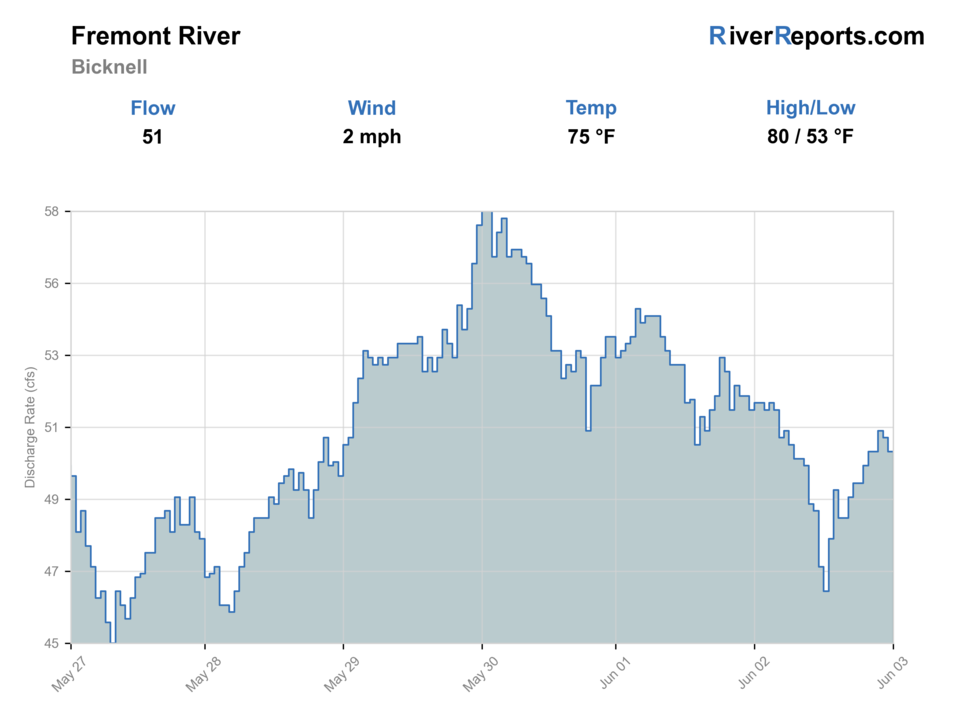
USGS data chart
Official USGS trend
Streamflow over the latest USGS reporting window.
Latest
51 cfs
Jun 3, 4 PM UTC
Weather
River weather report
Weather can change wading safety, road access, water temperature, hatches, and the best time of day to fish.
Live forecast loads as you reach this section
This keeps the report fast while still using the official National Weather Service forecast point.
Hatches and flies
Hatch chart and fly picks
April-June
Blue-winged olives, caddis, small attractor windows
BWO nymph, soft hackle, caddis pupa, Adams
June-August
Caddis and terrestrials during short low-light feeding windows
Elk hair caddis, ant, beetle, small hopper-dropper
September-October
Olives, caddis, sparse fall attractor windows
BWO dry, hare's ear, pheasant tail, olive bugger
Winter
Midges and occasional tiny olives
Zebra midge, RS2-style emerger, slim nymph
Small nymphs
Pheasant tail, hare's ear, zebra midge, perdigon
The best default whenever the river is clear enough to fish but too quiet for obvious surface activity.
Dry-dropper rigs
Adams, caddis dry, small hopper, beadhead dropper
Best in late spring through early fall when you need a mobile setup for mixed pocket and bank water.
Light streamers
Olive bugger, black bugger, slim leech
Useful around deeper slots, undercuts, or lower-light water where a single better trout may slide out.
Tactics
How to fish it
Decide before leaving the truck whether the day is a Bicknell Bottoms walk-in plan or a Capitol Reef upper-corridor stop, because the gear and expectations are different.
At Bicknell Bottoms, fish the cleaner channels thoroughly instead of wandering the whole wetland looking for a perfect seam that may not exist.
In the park corridor, keep wading short and deliberate. The scenic water can hide weaker fishery value and worse water-quality tradeoffs than the upstream look suggests.
If the flow chart looks good but the water is carrying obvious mud or warmth at the access point, trust the river in front of you and leave.
Rigging
Rod, leader, and setup notes
A 4- or 5-weight is enough for nearly every trout plan on the Fremont.
Carry 4X through 6X tippet and enough split shot to slow a small nymph through deeper slots or grassy channels.
Chest waders are often more useful than wet-wading in Bicknell Bottoms because the area can demand depth and brush tolerance, not just ankle access.
Bring a thermometer and treat it as a decision tool, not an accessory.
Access
Access and planning notes
Bicknell Bottoms WMA
Best public trout anchorWade / float / trail
Walk-in / wade
When to pick it
Start here when flow, clarity, and walk-in access support a short focused session.
Caution
Wetland footing, posted closures, and private edges still need current checks.
Upper Capitol Reef corridor
Short scenic scoutWade / float / trail
Roadside / selective wade
When to pick it
Use this only when the upper gorge has clear fishable water and park guidance supports the plan.
Caution
The lower Fruita corridor and long wades are not the same trout opportunity.
Fremont near Bicknell gauge
Primary flow readWade / float / trail
RiverReports / USGS gauge
When to pick it
Check it before deciding whether the day is fish, scout, or skip.
Caution
A good chart does not override muddy water, heat, or water-quality concerns at the access.
Bicknell Bottoms is walk-in only and can require waders, so do not plan on clean dry-shoe access to every channel.
Private land still shapes the Fremont corridor outside the named public areas. Keep the day tied to obvious public water and legal entry.
Capitol Reef access is great for viewing and short stops, but the park itself warns about Fremont River water quality and does not promise a uniform sport fishery through the whole Fruita reach.
Regulations
Check before fishing
Utah lists Bicknell Bottoms along the Fremont River as open to fishing except where posted closed. Recheck the current Utah Fishing Guidebook and any site-specific postings before fishing because closures and special-area rules can matter at small public corridors.
Primary base
Torrey, Bicknell, Loa, or a short Capitol Reef side trip built around one verified access zone
Best day style
Walk-in wetland and roadside canyon access where private land, water quality, and changing desert flow all matter
Check first
RiverReports, USGS 09330000, Utah guidebook rules, Bicknell Bottoms access conditions, and the NWS forecast
Safety
Walk-in wetland footing, variable desert runoff, private-land access constraints, hot-weather water quality, and long wading concerns in Capitol Reef
Gear
Helpful gear for this water
4- or 5-weight rod
Plenty for the Fremont's trout-focused windows and easier to manage in brushier access than a heavier setup.
Chest waders
More practical than ankle-height optimism at Bicknell Bottoms, especially when channels and wet ground spread out.
Thermometer
Important because the desert setting can leave the water fishable on paper but weaker in reality by midday.
Compact pack and water
A better fit than overloading the day when you may already be mixing hiking, scenic travel, and short fishing windows.
Nearby water
Other water to research
Backup logic
Muddy runoff
Wait for clarity or compare Green River, Duchesne River, or Yellowstone Creek.
Heat
Fish only cool windows and stop trout handling if the water warms.
Water-quality concern
Avoid long wading and move to a cleaner public-water option.
Access uncertainty
Stay with Bicknell Bottoms or verified park corridors instead of guessing at private frontage.
Green River
A stronger backup when you need a more reliable trout identity and can commit to a dedicated destination day.
Duchesne River
A useful alternative when Fremont conditions are too warm, too muddy, or too access-limited for a clean trout plan.
Yellowstone Creek
A smaller nearby-style planning alternative when you want mountain character instead of stretching a marginal desert-river day.
FAQ
Fast answers
Is Fremont River fishable today?
Fremont River looks very fishable right now. The live score is 96/100, based on current flow, weather, public alerts, and the report's planning context. Recheck the linked gauge and forecast before leaving because conditions can change quickly after rain, heat, access changes, or flow swings.
What flow is best for Fremont River?
Fish best on stable moderate flow that keeps Bicknell channels connected and the upper corridor clear enough to read without turning every step into a mud-and-brush problem.
When should I skip Fremont River?
Skip when the water is muddy, warm, or obviously degraded at the access point, when storms are pushing desert runoff, or when the only plan depends on unverified private-land frontage.
Is Fremont River safe to wade right now?
The fishability score is not a wading guarantee. Wade only where your chosen access has safe edges, clear footing, legal entry, and no forced crossings; high, rising, stained, or storm-affected water should be treated conservatively.
What gauge should I check for the Fremont River?
Start with RiverReports for the quick chart and keep USGS 09330000 open as the official flow backstop before deciding if Bicknell Bottoms or the upper park corridor is worth the trip.
Where is the safest public access on the Fremont River?
Bicknell Bottoms is the strongest public-water anchor because Utah DWR explicitly identifies it along the Fremont River and manages it for public use, but it is still walk-in only and often requires waders.
Can I just fish the Fremont River through Capitol Reef all day?
That is usually the wrong plan. Capitol Reef notes that the lower reaches through Fruita and downstream do not support the same sport fishery as the upstream gorge, and the park also warns about water-quality exposure in the river.
Sources
Source set for this report
Reviewed 2026-06-02