
Texas / Southwest
San Gabriel River
A San Gabriel River report for anglers planning Georgetown and Laneport water with live flow checks, named public access, and realistic Central Texas warmwater guidance.
Image: Generated regional planning image for San Gabriel River / BlueStreamFly generated; not exact location / BlueStreamFlyFishability now: San Gabriel River fishability today
GreatData confidence: High96/100
Fishable now because Laneport gauge is stable, weather is usable, and no public alert is active.
Flow observed
5:15 PM UTC
Weather observed
5:00 PM UTC
Score calculated
5:24 PM UTC
Why this rating
Flow
Weather
Public alerts
Next 6-12 hours
Hold
Stable live data supports staying with the plan, but recheck the gauge and forecast before leaving.
USGS flow
1,960 cfs
Current trend: flow stable, so weather, temperature, and access checks drive the next change.
More planning details: flies, flow bands, and live source checks
Fish it today
Start here
Start with the Laneport gauge, then pick Georgetown public access, a legal low-water crossing, or Tejas Park before choosing flies.
Best flow clue
Use the Laneport trend with water color and crossing safety. Stable or slowly falling water is the cleanest signal.
Skip trigger
Skip when low-water crossings are unsafe, storms stain the river, heat is excessive, park access is crowded, or the plan depends on unverified private banks.
Flow decision bands
Stable clear Laneport trend
Stable Laneport flow with clear limestone current is the best sign for bass, sunfish, and shoal fishing.
Best crossing and park window
Mild weather, safe crossings, confirmed public access, and no storm stain make the river most useful.
Rising or stained
Storm runoff can quickly turn the San Gabriel off-color and make low-water crossings a poor bet.
Hot, low, or access-limited
Thin summer water, unsafe parking, crowded parks, or private-bank uncertainty should push the plan elsewhere.
USGS flow
1,960 cfs
Current trend: flow stable, so weather, temperature, and access checks drive the next change.
Live USGS flow
1,960 cfs / stable
Live NWS forecast
84F / Mostly Sunny
Water temperature not verified
Heat guidance uses weather and river type unless an official water-temperature value is available.
No NWS alert flag
No active NWS alert was returned for this forecast point.
TPWD's Texas waterways analysis says the Georgetown City Park to Laneport section stays mostly 20 to 40 feet wide, keeps at least a minimum recreational flow most of the time, and is a good fit for inexperienced river users.
That same TPWD analysis names Georgetown City Park as a strong entry, noting about one-half mile of shoreline plus restrooms and picnic tables.
TPWD says low-water crossings provide adequate access through this reach, which is why bridge and park starts matter more here than long private-bank assumptions.
TPWD San Gabriel River records show Guadalupe bass, largemouth bass, white bass, bluegill, and Rio Grande cichlids on this water, which matches a mixed warmwater fly box instead of a one-pattern plan.
Editorial review
How this report is maintained
This report starts with official regulation, access, flow, weather, and public-water sources, then adds practical planning guidance for fly anglers.
Byline
BlueStreamFly editorial desk
Reviewed by
BlueStreamFly source review
Maintained by
BlueStreamFly
Last material review
2026-06-02
Report confidence
Good confidence
88/100
Good confidence: RiverReports, USGS Laneport flow, TPWD waterways, Georgetown and Tejas Park access context, TPWD water-body and freshwater-regulation sources, weather coverage, image disclosure, and route-specific warmwater guidance support the page. Confidence is moderated by low-water crossings, private frontage, storm stain, heat, and access crowding.
Regulations
TPWD freshwater regulation and water-body sources support the current legal and species-check path.
Access
Georgetown, Tejas Park, and TPWD waterways sources support public planning, with low-water crossing and private-frontage caution retained.
Flow and weather
RiverReports coverage is backed by USGS 08105700 at Laneport, and the National Weather Service point supports storm and heat decisions.
Fishing usefulness
The page now separates Laneport flow, Georgetown-area access, Tejas Park backup, low-crossing safety, summer heat, and backup-water choices.
Fishability dashboard and source review
2026-06-02 / material content or source review
RiverReports, USGS 08105700 at Laneport, TPWD waterways, Georgetown and Tejas Park access context, TPWD water-body and freshwater-regulation sources, image-disclosure, and National Weather Service sources were checked before updating the current-fishability decision layer.
2026-06-02
Updated San Gabriel River to the current fishability-page standard with Laneport trend bands, Georgetown and Tejas access cards, low-crossing and storm skip cues, stable fishability SEO, and confidence signals.
2026-05-27
Published a new San Gabriel River report with Georgetown and Laneport access guidance, RiverReports plus USGS flow support, and original warmwater planning notes.
Angler planning edge
Local details that change the plan
Best for
Central Texas Guadalupe bass, Georgetown-area short sessions, limestone shoal and crossing checks
Wade or float
Short wade, bank, or light paddle plans from named public access; confirm park rules and avoid private frontage.
Best flows
Use the Laneport trend with water color and crossing safety. Stable or slowly falling water is the cleanest signal.
When to skip
Skip when low-water crossings are unsafe, storms stain the river, heat is excessive, park access is crowded, or the plan depends on unverified private banks.
Local plan
Start with the Laneport gauge, then pick Georgetown public access, a legal low-water crossing, or Tejas Park before choosing flies.
Pressure
Georgetown-area access can be busy; earlier starts and simple public-entry plans help.
Access nuance
Public parks and listed access points help, but road crossings and lake-adjacent reaches require a legal-access check.
Backup water
Compare Bull Creek, Llano River, or Pedernales River when the San Gabriel is muddy, too hot, crowded, or access-limited.
About the river
Setting, character, and why it fishes the way it does.
The San Gabriel is formed at Georgetown where the North and South forks meet, then runs northeast toward Laneport and the Little River. That matters for fly anglers because the upper city stretch feels like a park-linked Central Texas river, while the lower Laneport reach opens into a quieter, broader corridor.
TPWD describes the Georgetown-to-Laneport section as a good recreational waterway with varied scenery, shallow water in dry periods, and access at multiple low-water crossings. That supports a practical fishing plan built around a few public entries and moderate expectations for long-distance wading.
This is still Hill Country-adjacent warmwater fishing. Limestone footing, summer heat, and fast runoff after storms shape the day as much as the fish do, especially where the water looks gentle from the bank but spreads wide and slick across the bottom.
Target species
Guadalupe bass
A headline fly-rod target on the San Gabriel and a good reason to focus on faster seams, broken limestone current, and clean moderate flow.
Largemouth and white bass
Useful secondary targets in deeper pools, slower bends, and broader lower-river buckets when the fast water is quiet.
Bluegill and Rio Grande cichlid
A realistic backup that keeps the day productive when bass activity is short or you are fishing the more urban Georgetown water.
Reading the water
Stable moderate flow
The best fit for wading shoals, fishing current tongues, and covering enough water without fighting soft muddy edges at every entry.
Slight rise with clear color
Often better than dead-low summer water because more lanes connect and fish spread out beyond the deepest pools.
Very low summer water
Shorten the day, stay near the strongest shade or current, and expect more pressure where the few fishable slots remain obvious.
Storm rise or chocolate color
A skip signal because crossings and limestone shelves lose footing margin quickly once runoff takes over.
Best seasons
Spring
Usually the best blend of moderate flow, active Guadalupe bass, and enough current definition to make the broad river fish well.
Early summer
Good for dawn topwater and small streamers before heat, swimmers, and lower water compress the fishable window.
Fall
Often the cleanest mix of stable weather, lighter park pressure, and clear water in the Georgetown corridor.
Winter
A selective warmwater season where mild afternoons and slower bugs or streamers in deeper slots matter more than numbers.
Preferred flow source
San Gabriel River at Laneport
RiverReports is the preferred chart source when coverage exists. When a matching USGS gauge exists, keep it open as the official backstop for station data and current hydrograph context.
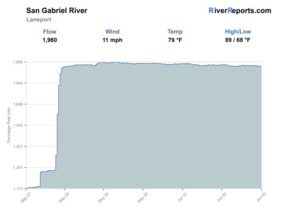
USGS data chart
Official USGS trend
Streamflow over the latest USGS reporting window.
Latest
1,960 cfs
Jun 3, 5 PM UTC
Weather
River weather report
Weather can change wading safety, road access, water temperature, hatches, and the best time of day to fish.
Live forecast loads as you reach this section
This keeps the report fast while still using the official National Weather Service forecast point.
Hatches and flies
Hatch chart and fly picks
March-May
Baitfish movement, crawfish activity, and mixed spring aquatic insects
Olive streamer, small craw pattern, black bugger, rubber-leg nymph
June-August
Terrestrials, minnows, and low-light topwater windows
Small popper, slider, foam bug, baitfish streamer, ant
September-November
Crawfish and baitfish feeding windows during cooler stable flows
Clouser, jig streamer, bugger, crayfish fly
Winter stable days
Sparse insect activity with slower forage-driven feeding
Small leech, jig streamer, lightly weighted bugger
Compact streamers
Small Clouser, woolly bugger, leech-style streamer, olive baitfish pattern
The first-choice set for San Gabriel bass water, especially around current seams, limestone shelves, and slower tailouts.
Topwater and foam
Small popper, slider, beetle, ant, foam bug
Best during calm early or late windows when fish slide onto softer banks and broken slicks.
Bottom-oriented bugs
Small crawfish fly, jig bug, rubber-leg nymph, soft hackle
Useful when clear water keeps fish low and the deeper ledges need a slower pass.
Tactics
How to fish it
Start with Georgetown City Park, Blue Hole, or another named public park and fish that section thoroughly before gambling on extra driving.
Treat the Laneport gauge corridor as a better fit for quieter warmwater fishing when the city stretch is crowded or low.
On moderate flows, work the inside seams and rock edges first because bass often sit where current has shape but not too much speed.
If the river is muddy, jumping fast, or full of weekend swimmers, leave rather than force a marginal public-water fit.
Rigging
Rod, leader, and setup notes
A 5- or 6-weight with floating line covers most San Gabriel fishing.
Use 2X to 4X for streamers and poppers, then lengthen a little for low clear water and smaller bugs.
Traction-focused wet-wading shoes matter because the limestone gets slick before the river looks difficult.
A light pack, thermometer, and weather radar check are more useful here than carrying a boat-size fly selection.
Access
Access and planning notes
Laneport gauge
Primary downstream trendWade / float / trail
RiverReports / USGS gauge / scout
When to pick it
Start here when flow direction, storm stain, and crossing safety decide the day.
Caution
The gauge does not confirm upstream park conditions, public parking, or private-bank access.
Georgetown public access
Most practical short sessionWade / float / trail
City park / bank / wade
When to pick it
Pick it when you want the simplest public plan around the Georgetown corridor.
Caution
Check posted park rules, parking, crowding, and slippery low-water crossings.
Tejas Park and lake-side backup
Upper-basin alternativeWade / float / trail
Park / bank / paddle context
When to pick it
Use it when the lower river plan is crowded or when Georgetown Lake context shapes the day.
Caution
Lake-adjacent water and river shoals can fish differently; confirm current access terms.
Use named Georgetown parks, trails, and public crossings only; long stretches outside town still border private land.
Tejas Park is better as an upper-basin backup access point than as a promise that the whole North Fork fishes well every day.
Weekend recreation pressure can reshape the best city-water windows, so dawn, weekdays, or the downstream Laneport section are often better angling fits.
Regulations
Check before fishing
Check TPWD freshwater regulations before fishing and follow posted Georgetown park or trail rules at the access point you use.
Primary base
Georgetown or the Laneport side of Williamson County
Best day style
Selective walk-in warmwater fishing with one Georgetown park start and one downstream backup
Check first
RiverReports, USGS 08105700, weather radar, Georgetown park access, and the lower river's water color
Safety
Flashy runoff, slick limestone, muddy low-water crossings, heat, and summer recreation pressure
Gear
Helpful gear for this water
5- or 6-weight rod
A practical match for bass bugs, small streamers, and all-day warmwater coverage.
Wet-wading shoes with real grip
Needed for slick rock and shallow pushy crossings.
Compact day pack
The best public entries reward mobility more than heavy gear.
Water and sun protection
Open Texas river corridors heat up quickly once the shade fades.
Nearby water
Other water to research
Backup logic
Muddy or rising water
Compare Bull Creek, Pedernales River, or Llano River before committing to stained crossings.
Heat
Fish early, focus on shaded current, or shift to a cooler or deeper backup.
Crowded park or crossing
Move to another named public access instead of improvising across private frontage.
Access uncertainty
Stay with city, county, federal, or clearly public land before fishing.
Bull Creek
A smaller Austin-area warmwater option when you want a shorter public-access session.
Llano River
A better move when you want a stronger named-access bass plan with less city pressure.
Pedernales River
Another Hill Country warmwater option when stable flow matters more than urban convenience.
FAQ
Fast answers
Is San Gabriel River fishable today?
San Gabriel River looks very fishable right now. The live score is 96/100, based on current flow, weather, public alerts, and the report's planning context. Recheck the linked gauge and forecast before leaving because conditions can change quickly after rain, heat, access changes, or flow swings.
What flow is best for San Gabriel River?
Use the Laneport trend with water color and crossing safety. Stable or slowly falling water is the cleanest signal.
When should I skip San Gabriel River?
Skip when low-water crossings are unsafe, storms stain the river, heat is excessive, park access is crowded, or the plan depends on unverified private banks.
Is San Gabriel River safe to wade right now?
The fishability score is not a wading guarantee. Wade only where your chosen access has safe edges, clear footing, legal entry, and no forced crossings; high, rising, stained, or storm-affected water should be treated conservatively.
Can you fly fish the San Gabriel River around Georgetown?
Yes, but the best plan is to use named public parks and crossings, check the Laneport gauge first, and fish it like a warmwater river with mixed bass and sunfish rather than a trout stream.
What should I watch before fishing the San Gabriel River?
Start with RiverReports and USGS 08105700, then confirm weather radar, water color, and the access point you want to use. Summer drought and fast storm rises both change the river quickly.
Is the San Gabriel better for wading or floating?
Most fly anglers will do better with selective wading from public parks and crossings. The Georgetown-to-Laneport section can float, but this page is built first for access-controlled walk-in fishing.
Sources
Source set for this report
Reviewed 2026-06-02