
Texas / Southwest
Pedernales River
A Pedernales River report for anglers planning the Johnson City and Pedernales Falls corridor with live flow checks, public-access limits, and realistic warmwater fly guidance.
Image: Generated regional planning image for Pedernales River / BlueStreamFly generated; not exact location / BlueStreamFlyFishability now: Pedernales River fishability today
GreatData confidence: High96/100
Fishable now because the live gauge is falling, weather is usable, and no public alert is active.
Flow observed
5:00 PM UTC
Weather observed
5:00 PM UTC
Score calculated
5:24 PM UTC
Why this rating
Flow
Weather
Public alerts
Next 6-12 hours
Improving / hold
A falling gauge and usable weather should keep the next 6-12 hours in play unless tributaries stain or heat builds.
USGS flow
25 cfs
Current trend: flow falling, rating likely holding strong unless weather or clarity changes.
More planning details: flies, flow bands, and live source checks
Fish it today
Start here
Start with the Johnson City gauge, then choose Pedernales Falls State Park or a verified crossing before picking flies.
Best flow clue
Use the Johnson City trend with clarity. Stable or slowly falling clear water is the best signal.
Skip trigger
Skip when the river is rising, muddy from storms, too low and hot, the falls area is closed or unsafe, or public access cannot be confirmed.
Flow decision bands
Clear stable limestone flow
Stable Johnson City flow with visible pocket water and readable seams is the best Pedernales fly-fishing signal.
Best state-park window
Mild weather, clear current, confirmed park access, and no closed-area warning make the river most fishable.
Storm pulse or stained water
Rising Hill Country water can turn pushy and off-color quickly; shorten the plan or wait for the trend to fall.
Low hot water or closure issue
Very low summer water, heat, closed falls access, or private-frontage uncertainty can make the trip a poor call.
USGS flow
25 cfs
Current trend: flow falling, rating likely holding strong unless weather or clarity changes.
Live USGS flow
25 cfs / falling about 31%
Live NWS forecast
82F / Partly Sunny
Water temperature not verified
Heat guidance uses weather and river type unless an official water-temperature value is available.
No NWS alert flag
No active NWS alert was returned for this forecast point.
TPWD says the Pedernales Falls State Park corridor is the main public-access anchor on this 39-mile reach, with only three road crossings across the broader section.
TPWD's waterways analysis says the river stays relatively shallow at normal levels and fishes or paddles best when it is on a 1 to 2 foot rise rather than scraping low.
Pedernales Falls State Park allows fishing and paddling, but it does not allow swimming, wading, or put-ins and take-outs in the falls area itself because the river can rise from calm to dangerous very quickly.
TPWD water-body records show the river supports Guadalupe bass, largemouth bass, white bass, catfish, carp, gar, and other mixed warmwater targets that fit a versatile Hill Country fly plan.
Editorial review
How this report is maintained
This report starts with official regulation, access, flow, weather, and public-water sources, then adds practical planning guidance for fly anglers.
Byline
BlueStreamFly editorial desk
Reviewed by
BlueStreamFly source review
Maintained by
BlueStreamFly
Last material review
2026-06-02
Report confidence
Good confidence
87/100
Good confidence: RiverReports, USGS Johnson City flow, Pedernales Falls State Park, TPWD waterways, river-fishing, water-body, and freshwater-regulation sources, weather coverage, image disclosure, and route-specific Hill Country guidance support the page. Confidence is moderated by flash-rise risk, closed park areas, private frontage, low summer water, and storm stain.
Regulations
TPWD freshwater regulation, river-fishing, and water-body sources support the legal and species-check path.
Access
Pedernales Falls State Park and TPWD waterways sources support public planning, with posted closures and private-frontage limits emphasized.
Flow and weather
RiverReports coverage is backed by USGS 08153500 near Johnson City, and the National Weather Service point supports storm and heat decisions.
Fishing usefulness
The page now separates Johnson City flow, state-park access, closed-area safety, storm stain, low-water heat, and backup-water choices.
Fishability dashboard and source review
2026-06-02 / material content or source review
RiverReports, USGS 08153500 near Johnson City, Pedernales Falls State Park, TPWD waterways, river-fishing, water-body, and freshwater-regulation sources, image-disclosure, and National Weather Service sources were checked before updating the current-fishability decision layer.
2026-06-02
Updated Pedernales River to the current fishability-page standard with Johnson City trend bands, Pedernales Falls access cards, storm and closed-falls skip cues, stable fishability SEO, and confidence signals.
2026-05-27
Published a new Pedernales River report with state-park access guidance, RiverReports plus USGS flow support, and original Hill Country warmwater planning notes.
Angler planning edge
Local details that change the plan
Best for
Hill Country Guadalupe bass, state-park short sessions, clear limestone pocket water
Wade or float
Wade, bank, or short paddle only from verified public access; do not treat private frontage, ranch roads, or closed park zones as open water.
Best flows
Use the Johnson City trend with clarity. Stable or slowly falling clear water is the best signal.
When to skip
Skip when the river is rising, muddy from storms, too low and hot, the falls area is closed or unsafe, or public access cannot be confirmed.
Local plan
Start with the Johnson City gauge, then choose Pedernales Falls State Park or a verified crossing before picking flies.
Pressure
State-park water and bridge checks can get busy, so early timing and a simple access plan matter.
Access nuance
Pedernales Falls State Park is the main public anchor, but posted park closures and the closed falls corridor decide where fishing is appropriate.
Backup water
Compare Llano River, Guadalupe River, or Bull Creek when Pedernales is muddy, too low, crowded, or access-limited.
About the river
Setting, character, and why it fishes the way it does.
The useful version of the Pedernales page is the Johnson City and Pedernales Falls corridor tied to the active gauge and the clearly documented public access points. It is not a promise that every scenic bend between ranches is a legal or worthwhile fly-fishing stop.
TPWD describes the Pedernales as an isolated Hill Country river with outstanding scenery, shallow water at normal levels, and better conditions when the river has a modest rise. That matches a fly plan built around current seams, boulder edges, and short mobile sessions.
This is also a river that demands respect for river safety. The same limestone and broad shallow structure that make it appealing can become slick, pushy, and hard to read after storms, especially near the falls corridor.
Target species
Guadalupe bass
The most natural fly-rod target in the faster river sections and a strong reason to focus on clean current and broken limestone water.
Largemouth and white bass
Useful supporting targets in deeper pools, slower runs, and broader lower-gradient sections when the river opens up.
Carp, catfish, gar, and mixed warmwater fish
A realistic part of the river's record book and worth keeping in mind when bass activity slows or lower-angle presentations make more sense.
Reading the water
Stable moderate flow
The best fit for wading selected runs, fishing seams off the limestone shelves, and covering enough water without forcing long hikes.
Slight rise
Often better than dead-low water because more channels connect and the current becomes easier to read, but only when the river still looks safe and clear.
Very low water
Shorten the day, target the strongest shade and slots, and accept that some broad famous-looking runs are just too thin to fish well.
Storm rise or muddy water
A strong skip signal because the park itself warns that the river can rise quickly and become dangerous within minutes.
Best seasons
Spring
Usually the strongest mix of moderate flows, active bass, and enough current to make the broad limestone structure fish well.
Early summer
Good for dawn surface action and compact streamer work before heavy heat and weekend traffic take over.
Fall
Often the cleanest combination of stable weather, lower crowd pressure, and readable water.
Winter
A selective warmwater season where mild afternoons and patient presentations matter more than numbers.
Preferred flow source
Pedernales River
RiverReports is the preferred chart source when coverage exists. When a matching USGS gauge exists, keep it open as the official backstop for station data and current hydrograph context.
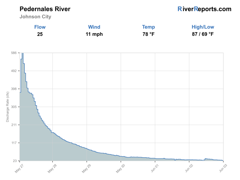
USGS data chart
Official USGS trend
Streamflow over the latest USGS reporting window.
Latest
25 cfs
Jun 3, 5 PM UTC
Weather
River weather report
Weather can change wading safety, road access, water temperature, hatches, and the best time of day to fish.
Live forecast loads as you reach this section
This keeps the report fast while still using the official National Weather Service forecast point.
Hatches and flies
Hatch chart and fly picks
March-May
Baitfish movement, crawfish activity, and mixed spring insects
Olive streamer, small craw pattern, rubber-leg bug, black bugger
June-August
Terrestrials, minnows, and dawn topwater windows
Small popper, slider, foam bug, baitfish streamer, ant
September-November
Crawfish and baitfish feeding windows in cooling water
Clouser, bugger, crayfish fly, jig streamer
Winter stable days
Sparse insect activity with slower forage-driven feeding
Small leech, jig streamer, lightly weighted bugger
Compact streamers
Small Clouser, woolly bugger, leech-style streamer, olive baitfish pattern
The first-choice set for current seams, deeper slots, and mixed bass water across the state-park corridor.
Topwater and foam
Small popper, slider, beetle, ant, foam bug
Best during calm low-light windows when bass push shallow along the limestone edges and softer banks.
Bottom-oriented bugs
Small crawfish fly, jig bug, rubber-leg nymph, soft hackle
Useful when the river is clear and fish hold low around rock shelves and slower buckets.
Tactics
How to fish it
Build the day around Pedernales Falls State Park or an obvious crossing rather than spending the morning trying to invent access.
Fish the first clean riffle-to-pool sequence thoroughly before hiking farther because public water is more limited than the map makes it look.
When the river is low, target the shade, drop-offs, and current tongues instead of casting across every wide shallow shelf.
If the water is rising, muddying, or pushing harder than expected, leave early rather than treating the falls corridor as a place to gamble.
Rigging
Rod, leader, and setup notes
A 5- or 6-weight with floating line covers most Pedernales fishing.
Use 2X to 4X for streamers and poppers, then lengthen slightly only when low clear water makes fish visibly wary.
Wet-wading shoes with real traction matter because the limestone gets slick well before the river looks dangerous.
A thermometer, radar check, and light pack are more important here than a heavy all-day setup.
Access
Access and planning notes
Johnson City gauge
Primary flow and trend checkWade / float / trail
RiverReports / USGS gauge / scout
When to pick it
Start here when storm pulses, low-water risk, and clarity decide whether to go.
Caution
The gauge does not confirm park openings, safe crossings, water color, or legal shoreline access.
Pedernales Falls State Park
Main public anchorWade / float / trail
State park / bank / wade / paddle
When to pick it
Use it for the most straightforward public plan when posted park rules and river conditions line up.
Caution
Respect closed falls areas, slick limestone, high-water closures, and park-specific rules.
US 281 and Hammett's Crossing
Quick corridor checksWade / float / trail
Road crossing / short look
When to pick it
Pick these only as practical public checks when a short session is safer than a longer park plan.
Caution
Roadside access can be limited; avoid trespass, unsafe parking, and private banks.
Stay inside state-park rules and obvious road rights-of-way; large private stretches separate the named entries.
Do not plan on swimming, wading, or launching in the Pedernales Falls area itself because the park explicitly restricts that zone for safety.
Reservations can matter on busy days because Pedernales Falls State Park can reach capacity and close to day visitors without permits.
Regulations
Check before fishing
Check TPWD freshwater regulations and any park-specific access or safety notices before fishing because this page relies on statewide warmwater rules plus state-park access conditions.
Primary base
Johnson City or a Hill Country day trip anchored to the state-park corridor
Best day style
Selective walk-in wading with one clear access point and one backup crossing
Check first
RiverReports, USGS 08153500, Pedernales Falls State Park status, weather radar, and crowd level
Safety
Flash flooding, slick limestone, long private stretches, and hazards near the falls
Gear
Helpful gear for this water
5- or 6-weight rod
A practical fit for mixed bass water, small streamers, and poppers.
Traction-focused wet-wading shoes
Needed for slick limestone shelves and shallow crossings.
Compact day pack
Public access is selective, so moving efficiently matters more than carrying extras.
Water and sun protection
The broad exposed river corridor gets hot quickly outside the shoulder seasons.
Nearby water
Other water to research
Backup logic
High or muddy water
Compare Llano River, Guadalupe River, or Bull Creek before forcing stained limestone water.
Low hot water
Fish early, shorten the route, or move to a more resilient Hill Country option.
Park closure or unsafe falls corridor
Use a different verified public access or leave the river for another day.
Private-frontage uncertainty
Stay with state-park or clearly public access before fishing.
Llano River
A better move when you want named leased access and a clearer bass-focused warmwater plan.
Guadalupe River
A stronger option when you want a more trout-oriented Texas fly plan.
Bull Creek
A shorter Austin-area backup when the Pedernales feels too crowded, too low, or too far for the day.
FAQ
Fast answers
Is Pedernales River fishable today?
Pedernales River looks very fishable right now. The live score is 96/100, based on current flow, weather, public alerts, and the report's planning context. Recheck the linked gauge and forecast before leaving because conditions can change quickly after rain, heat, access changes, or flow swings.
What flow is best for Pedernales River?
Use the Johnson City trend with clarity. Stable or slowly falling clear water is the best signal.
When should I skip Pedernales River?
Skip when the river is rising, muddy from storms, too low and hot, the falls area is closed or unsafe, or public access cannot be confirmed.
Is Pedernales River safe to wade right now?
The fishability score is not a wading guarantee. Wade only where your chosen access has safe edges, clear footing, legal entry, and no forced crossings; high, rising, stained, or storm-affected water should be treated conservatively.
What flow should I trust for the Pedernales River?
Use the RiverReports chart for a quick read and keep USGS 08153500 open as the official backstop before committing to the state-park corridor.
Can I fish right at Pedernales Falls?
Plan around the broader river corridor inside the park, not the falls zone itself. The park says swimming, wading, and put-ins or take-outs are not allowed in the falls area for safety.
When should I skip the Pedernales River?
Skip it when storms are nearby, the gauge is jumping, the water is muddy, or the public-access points are too crowded to make the limited legal water worth it.
Sources
Source set for this report
Reviewed 2026-06-02