
South Dakota / Midwest
Whitewood Creek
A Whitewood Creek near Vale report for anglers planning the lowest trout-capable Whitewood corridor with live flow checks, legal crossing access, and honest warm-season skip signals.
Image: Generated regional planning image for Whitewood Creek near Vale / BlueStreamFly generated; not exact location / BlueStreamFlyFishability now: Whitewood Creek fishability today
GreatData confidence: High91/100
Fishable now because the live gauge is falling, weather is mild, and no public alert is active.
Flow observed
5:00 PM UTC
Weather observed
5:00 PM UTC
Score calculated
5:27 PM UTC
Why this rating
Flow
Weather
Public alerts
Next 6-12 hours
Improving / hold
A falling gauge and usable weather should keep the next 6-12 hours in play unless tributaries stain or heat builds.
USGS flow
12 cfs
Current trend: flow falling, rating likely holding strong unless weather or clarity changes.
More planning details: flies, flow bands, and live source checks
Fish it today
Start here
Start with USGS 06436198 near Vale, then choose a legal crossing or move upstream to Whitewood or upper Whitewood before picking flies.
Best flow clue
Use the Vale gauge with lower-valley clarity and temperature. Stable cool flow is required before this route makes sense.
Skip trigger
Skip when water is warm, colored, rising, muddy after storms, private access is uncertain, or the lower valley looks too exposed for trout.
Flow decision bands
Stable Vale flow
Stable USGS Vale flow with cool, clear lower-valley water is the minimum good signal.
Best lower-valley window
Mild weather, confirmed public crossings, clear water, and enough trout temperature margin make the route useful.
Warm or colored lower water
Heat, stain, mining-history color changes, or muddy storm pulses should move the plan upstream.
Access or footing uncertainty
Private banks, slick lower banks, and unclear right-of-way access are enough to skip the reach.
USGS flow
12 cfs
Current trend: flow falling, rating likely holding strong unless weather or clarity changes.
Live USGS flow
12 cfs / falling about 31%
Live NWS forecast
68F / Slight Chance Rain Showers
Water temperature not verified
Heat guidance uses weather and river type unless an official water-temperature value is available.
No NWS alert flag
No active NWS alert was returned for this forecast point.
South Dakota's Black Hills stream-management plan treats Whitewood Creek as a managed trout system, but the lower valley near Vale is the reach where clarity, temperature, and corridor openness matter most before the drainage loses its best trout feel.
USGS site 06436198 near Vale gives this route a distinct official flow read separate from the upstream Whitewood and Deadwood gauges, which matters when lower-valley conditions lag or warm faster than the headwaters.
South Dakota states that Black Hills stream access comes through adjacent-landowner permission or a public right-of-way such as a road crossing or public land, which is the only safe planning lens for the Vale corridor.
Mining-history cleanup and lower-valley exposure mean this route deserves a more conservative go-or-no-go standard than the tighter upper Whitewood pages.
Editorial review
How this report is maintained
This report starts with official regulation, access, flow, weather, and public-water sources, then adds practical planning guidance for fly anglers.
Byline
BlueStreamFly editorial desk
Reviewed by
BlueStreamFly source review
Maintained by
BlueStreamFly
Last material review
2026-06-02
Report confidence
Good confidence
84/100
Good confidence: RiverReports, USGS Vale flow, upstream Whitewood flow context, South Dakota GFP stream plan and 2026 handbook, weather coverage, image disclosure, and route-specific lower-valley guidance support the page. Confidence is moderated by private-bank limits, lower-valley heat, color changes, storm runoff, and access uncertainty.
Regulations
South Dakota GFP stream-plan and 2026 fishing handbook sources support the trout-rule and species-check path.
Access
South Dakota right-of-way guidance supports a conservative bridge-and-permission access plan, but no broad public corridor is documented for the lower valley.
Flow and weather
RiverReports coverage is backed by USGS 06436198 near Vale with upstream USGS context, and the National Weather Service point supports storm and heat decisions.
Fishing usefulness
The page now separates Vale flow, lower-valley temperature and clarity, public right-of-way access, private-bank risk, and backup-water choices.
Fishability dashboard and source review
2026-06-02 / material content or source review
RiverReports, USGS 06436198 near Vale, USGS 06436190 near Whitewood, South Dakota GFP Black Hills stream plan and 2026 handbook, image-disclosure, and National Weather Service sources were checked before updating the current-fishability decision layer.
2026-06-02
Updated Whitewood Creek near Vale to the current fishability-page standard with Vale trend bands, lower-valley right-of-way access cards, heat and color skip cues, backup logic, stable fishability SEO, and confidence signals.
2026-05-27
Published a new Whitewood Creek near Vale report with lower-valley access guidance, trout-margin skip signals, and same-drainage backup planning.
Angler planning edge
Local details that change the plan
Best for
lower Whitewood trout checks, short bridge-based sessions, brown trout undercut and bank water
Wade or float
Make short bank and careful wade checks from clearly public road crossings; do not plan a continuous private-valley walk.
Best flows
Use the Vale gauge with lower-valley clarity and temperature. Stable cool flow is required before this route makes sense.
When to skip
Skip when water is warm, colored, rising, muddy after storms, private access is uncertain, or the lower valley looks too exposed for trout.
Local plan
Start with USGS 06436198 near Vale, then choose a legal crossing or move upstream to Whitewood or upper Whitewood before picking flies.
Pressure
This is less about crowds and more about whether the lower reach still has trout-credible water and legal access.
Access nuance
South Dakota right-of-way guidance keeps this page bridge-and-permission focused; the open valley is not open access.
Backup water
Move to Whitewood Creek at Whitewood, upper Whitewood, or Spearfish Creek Spearfish when Vale is warm, colored, or access-uncertain.
About the river
Setting, character, and why it fishes the way it does.
This page is not a generic Whitewood Creek summary. It is the downstream Vale corridor, where the drainage opens up, access gets more private, and the trout decision depends even more on clear cool flow than it does upstream.
The useful Vale version of Whitewood is a short crossing-to-crossing plan, not a promise that the whole valley is publicly fishable. Treat it as a reach you earn only when the lower gauge and the water in front of you still say trout.
Because this corridor sits farther from the higher, colder upper basin, it is also the quickest Whitewood route to lose quality during heat or after runoff. That makes your skip decision part of the value here, not a failure of the page.
Target species
Brown trout
The clearest fit for the lower Whitewood Vale corridor, especially when deeper banks and undercuts hold fish through warming periods.
Rainbow trout
Still part of the documented Whitewood trout mix and worth expecting when the lower valley holds stable cool flow.
Brook trout
More of an upstream-drainage context fish than a Vale expectation, but still part of the watershed identity this page depends on.
Reading the water
Clear cool stable flow
Best for lower-valley nymphing and short streamer passes through the deepest defined runs and undercuts.
Late-spring or summer warmth
Watch temperature and fish handling closely because this reach loses its trout margin earlier than the upper corridor.
After rain or runoff color
A strong skip signal because the lower valley can hold off-color water longer than the headwaters.
Cold clear shoulder seasons
Often the most realistic time to fish Vale without forcing the marginal lower-reach summer conditions.
Best seasons
Spring
Good only when runoff stays controlled enough to preserve clear lower-valley seams.
Early summer
Fishable on cool stable mornings, but not a reach to force through heat or low clarity.
Fall
Usually the cleanest season for a Vale check because cooler nights help the trout margin.
Winter
Possible in short windows, but not worth the drive unless gauges and weather align cleanly.
Preferred flow source
Whitewood Creek near Vale
RiverReports is the preferred chart source when coverage exists. When a matching USGS gauge exists, keep it open as the official backstop for station data and current hydrograph context.
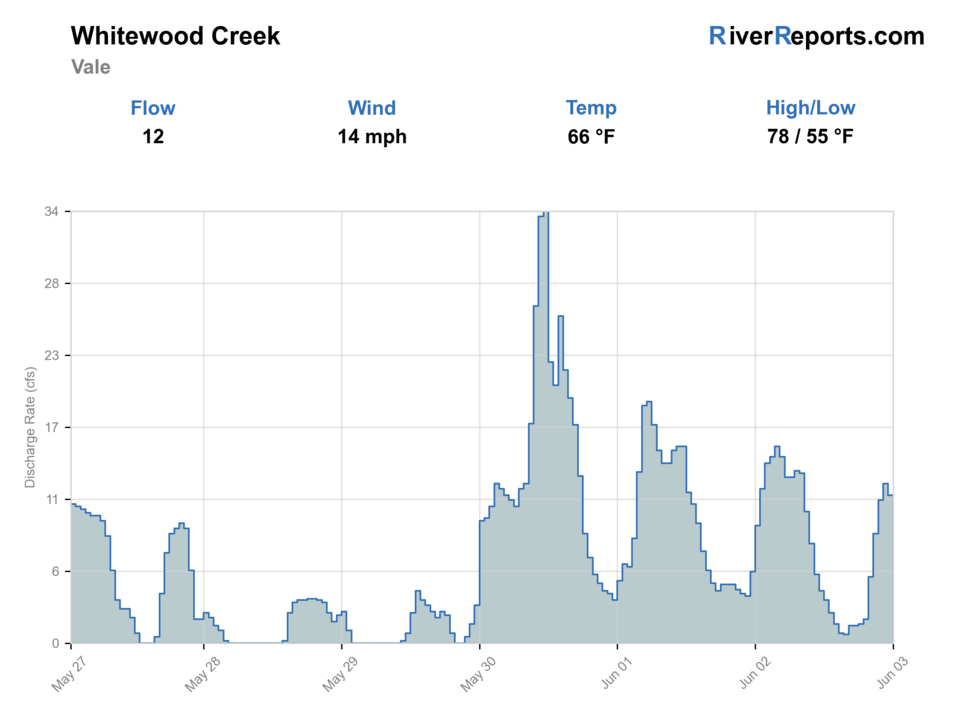
USGS data chart
Official USGS trend
Streamflow over the latest USGS reporting window.
Latest
12 cfs
Jun 3, 5 PM UTC
Weather
River weather report
Weather can change wading safety, road access, water temperature, hatches, and the best time of day to fish.
Live forecast loads as you reach this section
This keeps the report fast while still using the official National Weather Service forecast point.
Hatches and flies
Hatch chart and fly picks
March-May
Blue-winged olives, midges, small caddis
BWO nymph, zebra midge, tan caddis pupa
Late spring
Caddis and mixed mayflies
Soft hackle, hare's ear, prince nymph
Summer
Caddis, terrestrials, sparse streamer windows
Elk hair caddis, foam ant, olive bugger
Fall
BWOs, midges, streamer windows
RS2, zebra midge, black bugger
Core nymphs
Hare's ear, prince, pheasant tail, zebra midge
The best starting point for deeper lower-valley slots and cooler stable mornings.
Small streamers
Olive bugger, black bugger, mini leech
Useful when slight color or deeper banks make a more visible fly the better call.
Dry-dropper
Elk hair caddis, parachute Adams, foam ant with a small nymph
Worth a look only when the lower creek still feels cool, clear, and distinctly trout-friendly.
Tactics
How to fish it
Fish the deepest legal crossing water first because the lower valley loses quality faster than the upper reach.
Keep one eye on temperature and clarity all day instead of assuming a clean first bend means the whole corridor is in shape.
If the creek looks marginal, move upstream rather than hoping the next crossing will save the day.
Treat this route as a precise lower-basin check, not as an all-day wander.
Rigging
Rod, leader, and setup notes
A 4- to 6-weight with floating line covers most Vale situations well.
Carry 4X to 5X for nymphs and streamers, and go lighter only when the creek is exceptionally clear and cool.
A thermometer is essential here because lower-valley summer decisions should be driven by actual conditions, not optimism.
Reliable boot traction matters on muddy banks and undercut entries near crossings.
Access
Access and planning notes
Vale gauge
Primary lower-reach trendWade / float / trail
RiverReports / USGS gauge / trout
When to pick it
Start here when lower-valley stability, clarity, and temperature decide whether the route is worth checking.
Caution
The gauge does not make private valley banks public or confirm every bridge's safe footing.
Vale-area public road crossings
Legal short checksWade / float / trail
Road right-of-way / bank / short wade
When to pick it
Use only clearly public crossings when the water still looks trout-credible.
Caution
Do not string together bends through private land unless access is confirmed.
Whitewood town reach backup
Same-drainage fallbackWade / float / trail
Bridge corridor / bank / wade
When to pick it
Pick it when Vale loses clarity or temperature margin but upstream water still looks usable.
Caution
Upstream still requires public right-of-way or permission discipline.
South Dakota says Black Hills stream access comes through landowner permission or a public right-of-way such as a road crossing or public land.
Do not turn the open valley into a trespass-risk shortcut between bends.
If the lower corridor is not clearly legal and trout-credible, move upstream.
Regulations
Check before fishing
Recheck the 2026 South Dakota Fishing Handbook before fishing because Black Hills trout regulations and seasonal exceptions can change.
Primary base
Whitewood, Vale, or a northern Black Hills day with Whitewood and Spearfish backup options already mapped
Best day style
Bridge-and-right-of-way trout checks on the lower valley corridor, with strict private-land caution and no float assumption
Check first
RiverReports, USGS 06436198, lower-valley weather, the South Dakota fishing handbook, and real-time water clarity and temperature
Safety
Heat, off-color water, private-land boundaries, slick lower banks, and fast storms moving out of the Black Hills
Gear
Helpful gear for this water
4- to 6-weight rod
A solid fit for lower-valley nymphing and compact streamers when the creek still holds enough push.
Thermometer
Mandatory on this route because lower-valley trout decisions depend on actual water temperature.
Polarized glasses
Helpful for reading clarity, depth, and undercut banks before you commit to a marginal crossing.
Wading staff
Useful when muddy banks or deeper lower runs make entry less obvious than they looked from the road.
Nearby water
Other water to research
Backup logic
Lower water is warm
Move upstream, fish early only, or stop trout fishing.
Color or storm pulse
Compare Whitewood at Whitewood, upper Whitewood, or Spearfish before fishing Vale.
Access uncertainty
Stay at confirmed public crossings or choose a route with clearer public access.
Thin or exposed water
Move upstream to colder cover or pick a different Black Hills trout page.
Whitewood Creek Whitewood
The best same-drainage fallback when Vale loses clarity or trout temperature margin.
Whitewood Creek Above Whitewood
The better move when you want colder tighter upper-basin water and a more obvious public trail corridor.
Spearfish Creek Spearfish
A stronger backup when you want obvious public access and a more established town-water trout plan.
FAQ
Fast answers
Is Whitewood Creek fishable today?
Whitewood Creek looks very fishable right now. The live score is 91/100, based on current flow, weather, public alerts, and the report's planning context. Recheck the linked gauge and forecast before leaving because conditions can change quickly after rain, heat, access changes, or flow swings.
What flow is best for Whitewood Creek?
Use the Vale gauge with lower-valley clarity and temperature. Stable cool flow is required before this route makes sense.
When should I skip Whitewood Creek?
Skip when water is warm, colored, rising, muddy after storms, private access is uncertain, or the lower valley looks too exposed for trout.
Is Whitewood Creek safe to wade right now?
The fishability score is not a wading guarantee. Wade only where your chosen access has safe edges, clear footing, legal entry, and no forced crossings; high, rising, stained, or storm-affected water should be treated conservatively.
What flow should I trust for Whitewood Creek near Vale?
Use the RiverReports chart for quick reads and keep USGS site 06436198 open as the official lower-reach backstop.
When should I skip the Vale reach and move upstream?
Move upstream when the lower creek is warming, carrying color, or losing enough depth that it no longer looks like honest trout water.
Can I fish the open lower valley wherever I can see the creek?
No. South Dakota says legal access comes through adjacent-landowner permission or a public right-of-way such as a road crossing or public land.
Sources
Source set for this report
Reviewed 2026-06-02