
South Dakota / Midwest
Whitewood Creek
A Whitewood Creek near Whitewood report for anglers planning bridge-access trout water, quick flow checks, and conservative valley-wading decisions on the lower Black Hills corridor.
Image: Generated regional planning image for Whitewood Creek near Whitewood / BlueStreamFly generated; not exact location / BlueStreamFlyFishability now: Whitewood Creek fishability today
GreatData confidence: High96/100
Fishable now because Whitewood gauge is falling, weather is mild, and no public alert is active.
Flow observed
4:15 PM UTC
Weather observed
5:00 PM UTC
Score calculated
5:27 PM UTC
Why this rating
Flow
Weather
Public alerts
Next 6-12 hours
Improving / hold
A falling gauge and usable weather should keep the next 6-12 hours in play unless tributaries stain or heat builds.
USGS flow
11 cfs
Current trend: flow falling, rating likely holding strong unless weather or clarity changes.
More planning details: flies, flow bands, and live source checks
Fish it today
Start here
Start with the Whitewood gauge, check a legal bridge corridor, and keep upper Whitewood or Spearfish ready if color, heat, or access is not right.
Best flow clue
Use USGS 06436190 near Whitewood with upstream gauge context. Stable, clear, cool flow is the best signal.
Skip trigger
Skip when flow is rising, water is colored after storms, legal access is uncertain, water is warm, banks are slick, or private boundaries are unclear.
Flow decision bands
Stable Whitewood flow
Stable USGS Whitewood flow with clear water and cool conditions is the best town-corridor signal.
Best bridge-check window
Mild weather, legal right-of-way access, clear water, and safe footing make short sessions most useful.
Rising or colored water
Storm pulses, mining-history color changes, or rising flow should move the plan upstream or elsewhere.
Warm or private-boundary risk
Warm trout conditions or unclear ownership are enough to skip the route even if the gauge is stable.
USGS flow
11 cfs
Current trend: flow falling, rating likely holding strong unless weather or clarity changes.
Live USGS flow
11 cfs / falling about 10%
Live NWS forecast
67F / Partly Sunny
Water temperature not verified
Heat guidance uses weather and river type unless an official water-temperature value is available.
No NWS alert flag
No active NWS alert was returned for this forecast point.
South Dakota's Black Hills stream-management plan identifies Whitewood Creek from I-90 to the confluence with Whitetail and Englewood Creeks as a 25.8-mile managed reach, with multiple trout-class samples that support a trout-focused plan rather than a generic warmwater assumption.
The same plan says Whitewood Creek still carries mining-related issues in parts of the drainage, even though cleanup work and fish recovery have progressed, so clear stable water matters more here than on a simpler headwater creek.
South Dakota states that legal stream access on Black Hills waters comes through permission from adjacent landowners or a public right-of-way such as a road crossing or public land, which is the right access lens for the Whitewood corridor near town.
USGS site 06436190 tracks Whitewood Creek near Whitewood with a 77.3-square-mile drainage area, giving this route a dependable official flow reference for valley conditions.
Editorial review
How this report is maintained
This report starts with official regulation, access, flow, weather, and public-land sources, then adds practical planning guidance for fly anglers.
Byline
BlueStreamFly editorial desk
Reviewed by
BlueStreamFly source review
Maintained by
BlueStreamFly
Last material review
2026-06-02
Report confidence
Good confidence
86/100
Good confidence: RiverReports, USGS Whitewood flow, upstream Whitewood gauge context, City of Deadwood trail backup, South Dakota GFP stream plan and 2026 handbook, weather coverage, image disclosure, and route-specific town-corridor guidance support the page. Confidence is moderated by private-boundary limits, water color, storm response, footing, and summer heat.
Regulations
South Dakota GFP stream-plan and 2026 fishing handbook sources support the trout-rule and species-check path.
Access
Right-of-way and public-land guidance support a conservative access plan, while the Deadwood trail gives an upstream public backup.
Flow and weather
RiverReports coverage is backed by USGS 06436190 near Whitewood with upstream USGS context, and the National Weather Service point supports storm and heat decisions.
Fishing usefulness
The page now separates Whitewood flow, bridge-right-of-way access, upstream backup choices, color-change caution, trout heat risk, and private-boundary limits.
Fishability dashboard and source review
2026-06-02 / material content or source review
RiverReports, USGS 06436190 near Whitewood, USGS 06436180 above Whitewood, City of Deadwood Whitewood Creek Trail, South Dakota GFP Black Hills stream plan and 2026 handbook, image-disclosure, and National Weather Service sources were checked before updating the current-fishability decision layer.
2026-06-02
Updated Whitewood Creek at Whitewood to the current fishability-page standard with Whitewood trend bands, bridge-right-of-way and trail-backup access cards, mining-history color skip cues, backup logic, stable fishability SEO, and confidence signals.
2026-05-27
Published a new Whitewood Creek near Whitewood report with legal-access guidance, valley-flow planning, and lower Black Hills safety notes.
Angler planning edge
Local details that change the plan
Best for
Whitewood town-corridor trout, bridge and right-of-way checks, brown and rainbow trout windows
Wade or float
Bank and wade from clearly public right-of-way or permission-based access; this is a short-check route, not an assumption that the whole creek is open.
Best flows
Use USGS 06436190 near Whitewood with upstream gauge context. Stable, clear, cool flow is the best signal.
When to skip
Skip when flow is rising, water is colored after storms, legal access is uncertain, water is warm, banks are slick, or private boundaries are unclear.
Local plan
Start with the Whitewood gauge, check a legal bridge corridor, and keep upper Whitewood or Spearfish ready if color, heat, or access is not right.
Pressure
Pressure is usually less important than legal access certainty, water color, and whether the town reach still looks trout-credible.
Access nuance
Use public right-of-way, public land, or permission. The Deadwood trail is a useful upstream backup, not proof that every Whitewood bend is open.
Backup water
Compare upper Whitewood, Whitewood near Vale, Spearfish Creek Spearfish, or Spearfish Canyon when the town reach is colored, warm, or access-limited.
About the river
Setting, character, and why it fishes the way it does.
This Whitewood page is intentionally scoped to the near-Whitewood corridor instead of the tighter upstream water above town or the broader downstream valley toward Vale. That narrower scope keeps the access advice honest and lines up with the RiverReports and USGS station pairing for this reach.
Whitewood Creek is not a place to improvise across private banks. The useful version of this report is a disciplined bridge-access and right-of-way plan with short looks into the better bends, undercuts, and current breaks that stay legally reachable.
The drainage has a long mining and cleanup history, so practical anglers should treat water clarity, recent rain, and any unusual discoloration as decision-making inputs instead of assuming every fishable-looking run is the same from one week to the next.
Target species
Brown trout
The main planning target for the Whitewood corridor, especially through the deeper valley bends and cover-rich banks.
Rainbow trout
Part of the documented Whitewood trout mix and worth expecting in the steadier runs.
Brook trout
More common in colder upstream sections, but still useful as part of the broader Whitewood drainage context.
Reading the water
Clear stable flow
Best for short nymph or streamer passes through outside bends, cutbanks, and bridge-current seams.
After rain
Watch for fast color changes because Black Hills storm pulses can move quickly through Whitewood Creek.
Lower summer flow
Fish early, keep sessions short, and skip the day if clarity drops or water temperatures lose the trout margin.
Cold shoulder seasons
A good fit for compact midday windows when you want current but do not need an all-day walk.
Best seasons
Spring
Good when runoff is not blowing out the creek and trout use the deeper valley slots with confidence.
Early summer
Worth the drive on stable clear flow, especially before hot weather shortens the safe trout window.
Fall
Often the cleanest planning season for a bridge-to-bridge trout check with less heat risk.
Winter
Possible in short spurts, but ice edges and valley shading make this a selective, conservative call.
Preferred flow source
Whitewood Creek at Whitewood
RiverReports is the preferred chart source when coverage exists. When a matching USGS gauge exists, keep it open as the official backstop for station data and current hydrograph context.
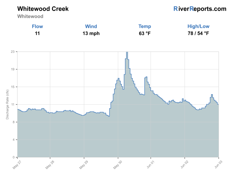
USGS data chart
Official USGS trend
Streamflow over the latest USGS reporting window.
Latest
11 cfs
Jun 3, 4 PM UTC
Weather
River weather report
Weather can change wading safety, road access, water temperature, hatches, and the best time of day to fish.
Live forecast loads as you reach this section
This keeps the report fast while still using the official National Weather Service forecast point.
Hatches and flies
Hatch chart and fly picks
March-May
Blue-winged olives, midges, little black stones
BWO nymph, zebra midge, black stonefly
May-June
Caddis and mixed mayflies
Soft hackle, hare's ear, tan caddis pupa
Summer
Caddis, terrestrials, attractor windows
Elk hair caddis, foam ant, beetle, prince nymph
Fall
BWOs, midges, streamer windows
RS2, zebra midge, olive bugger
Core nymphs
Pheasant tail, hare's ear, prince, perdigon
The best starting point for bridge-access drifts and moderate slots.
Small streamers
Olive bugger, black bugger, leech-style mini streamer
Useful in darker bends or after slight color changes when trout stop rising.
Dry-dropper
Parachute Adams, elk hair caddis, foam ant with a small nymph
Worth trying on clear stable flow when the creek feels settled rather than stormy.
Tactics
How to fish it
Treat Whitewood as a sequence of short legal stops instead of one long continuous wade.
Fish the first obvious seam below a bridge or right-of-way before walking farther because pressure and limited public reach make the near water important.
If clarity is falling, switch to a shorter heavier nymph pass or a compact streamer and leave once the creek stops reading cleanly.
Do not force midstream positions when the better decision is covering accessible banks and protecting your exit route.
Rigging
Rod, leader, and setup notes
A 9-foot 4- to 6-weight covers most Whitewood near-town situations well.
Carry 4X through 5X tippet for nymphs and streamers, with 6X only when the creek is exceptionally clear and calm.
A compact indicator rig or tight-line setup works better here than overbuilt multi-fly rigs.
Sticky soles and a wading staff are useful because bank entries can be uneven and slippery after rain.
Access
Access and planning notes
Whitewood gauge
Primary town-flow trendWade / float / trail
RiverReports / USGS gauge / trout
When to pick it
Start here when the town reach needs a direct flow and clarity check.
Caution
The gauge does not confirm legal access, safe footing, local signs, or water color at every crossing.
Whitewood bridge right-of-way
Short legal checksWade / float / trail
Road crossing / bank / short wade
When to pick it
Use only clearly public right-of-way or permission-based access when water is cool and clear.
Caution
Do not use bridges as a shortcut into private-bank water.
Deadwood trail upstream backup
Colder public-corridor optionWade / float / trail
Trail / bank / wade
When to pick it
Pick it when town water is warm, colored, or access-uncertain but upper flow still looks stable.
Caution
The trail helps the upper page more than the town page; confirm signs and public access.
South Dakota says Black Hills stream access comes through landowner permission or a public right-of-way such as a road crossing or public land.
If the ownership picture is not obvious from the crossing, skip the bend and keep moving.
This is not the creek to turn into a fence-hopping exploration day.
Regulations
Check before fishing
Recheck the 2026 South Dakota Fishing Handbook before fishing because trout limits and Black Hills exceptions can change by water and season.
Primary base
Whitewood, Deadwood, or a northern Black Hills day built around quick legal stops instead of one long float or hike
Best day style
Mostly short bridge-and-right-of-way stops with selective walk-in fishing, not an all-day public-land wade program
Check first
RiverReports, USGS 06436190, Whitewood-area weather, South Dakota stream-access rules, and the current South Dakota fishing handbook
Safety
Fast storm pulses, private-land boundaries, slick banks, valley heat, and water-color changes tied to runoff or disturbance
Gear
Helpful gear for this water
4- to 6-weight rod
A practical fit for nymphing, small streamers, and compact dry-dropper rigs on valley trout water.
Wading staff
Helpful because the legal entries are often short, steep, and uneven rather than soft trail access.
Thermometer
Useful on summer afternoons when lower-valley trout handling becomes the real decision point.
Rain shell
Black Hills thunderstorms can change flow and footing quickly.
Nearby water
Other water to research
Backup logic
Town water is colored
Compare upper Whitewood or Spearfish Creek before fishing through the color change.
Warm trout conditions
Fish early, move upstream, or stop trout fishing.
Right-of-way uncertainty
Choose upper Whitewood trail water or Spearfish town water with clearer public access.
Storms or slick banks
Stay bank-first or switch to a route with safer footing and exits.
Spearfish Creek Spearfish
The stronger backup when you want a more obvious in-town public corridor with less access ambiguity.
Spearfish Creek
A better option when you want a colder larger system and can commit to a more trout-specific day.
Whitewood Creek Above Whitewood
A pending upstream reach worth watching when you want tighter colder water than the lower Whitewood valley.
FAQ
Fast answers
Is Whitewood Creek fishable today?
Whitewood Creek looks very fishable right now. The live score is 96/100, based on current flow, weather, public alerts, and the report's planning context. Recheck the linked gauge and forecast before leaving because conditions can change quickly after rain, heat, access changes, or flow swings.
What flow is best for Whitewood Creek?
Use USGS 06436190 near Whitewood with upstream gauge context. Stable, clear, cool flow is the best signal.
When should I skip Whitewood Creek?
Skip when flow is rising, water is colored after storms, legal access is uncertain, water is warm, banks are slick, or private boundaries are unclear.
Is Whitewood Creek safe to wade right now?
The fishability score is not a wading guarantee. Wade only where your chosen access has safe edges, clear footing, legal entry, and no forced crossings; high, rising, stained, or storm-affected water should be treated conservatively.
What flow should I trust for Whitewood Creek near Whitewood?
Use the RiverReports chart for quick reads and keep USGS site 06436190 open as the official near-Whitewood backstop.
Can I just pull over anywhere on Whitewood Creek?
No. South Dakota says legal Black Hills stream access comes through landowner permission or a public right-of-way such as a road crossing or public land.
Why is Whitewood Creek a cautious clarity call after rain?
South Dakota's stream-management plan says mining-related issues still exist in parts of the drainage, so stable clear water is a much better trigger than optimistic guesswork after storms.
Sources
Source set for this report
Reviewed 2026-06-02