
South Dakota / Midwest
Whitewood Creek
A Whitewood Creek above Whitewood report for anglers planning the colder, tighter upper corridor with live flow checks, legal walk-in access, and honest storm-surge warnings.
Image: Generated regional planning image for Whitewood Creek above Whitewood / BlueStreamFly generated; not exact location / BlueStreamFlyFishability now: Whitewood Creek fishability today
GreatData confidence: High96/100
Fishable now because the live gauge is stable, weather is mild, and no public alert is active.
Flow observed
4:50 PM UTC
Weather observed
5:00 PM UTC
Score calculated
5:26 PM UTC
Why this rating
Flow
Weather
Public alerts
Next 6-12 hours
Hold
Stable live data supports staying with the plan, but recheck the gauge and forecast before leaving.
USGS flow
13 cfs
Current trend: flow stable, so weather, temperature, and access checks drive the next change.
More planning details: flies, flow bands, and live source checks
Fish it today
Start here
Start with USGS 06436180 and the Deadwood trail corridor, then decide whether to stay high, slide toward Whitewood, or use a Spearfish backup.
Best flow clue
Use the above-Whitewood gauge with clarity and upper-basin weather. Stable cool flow is the best signal.
Skip trigger
Skip when water is stained, flow is rising, storms are active, legal access is uncertain, water is warm, or trail footing is unsafe.
Flow decision bands
Stable upper-basin flow
Stable USGS above-Whitewood flow with cool weather and clear water is the best upper Whitewood signal.
Best trail-corridor window
Mild weather, safe trail footing, legal public access, and clear water make this route most useful.
Color change or rising water
Mining-history color changes, storm stain, or rising flow should move the plan downstream, bank-first, or elsewhere.
Warm or access-uncertain
Warm trout conditions or any ownership guesswork should stop the plan before the fishing decision.
USGS flow
13 cfs
Current trend: flow stable, so weather, temperature, and access checks drive the next change.
Live USGS flow
13 cfs / stable
Live NWS forecast
65F / Partly Sunny
Water temperature not verified
Heat guidance uses weather and river type unless an official water-temperature value is available.
No NWS alert flag
No active NWS alert was returned for this forecast point.
South Dakota's Black Hills stream-management plan identifies Whitewood Creek from the upper watershed through the Whitewood corridor as a managed trout drainage, with brook, brown, and rainbow trout documented in different parts of the system.
The City of Deadwood maintains the Whitewood Creek Trail, which gives this upper-reach page a more defensible walk-in public corridor than the downstream valley pages.
South Dakota says legal Black Hills stream access comes through adjacent-landowner permission or a public right-of-way such as a road crossing or public land, which keeps this page anchored to the trail and clearly public entries.
USGS site 06436180 tracks Whitewood Creek above Whitewood and gives this reach the best official read on upper-corridor stability before you commit to a trout session.
Editorial review
How this report is maintained
This report starts with official regulation, access, flow, weather, and public-water sources, then adds practical planning guidance for fly anglers.
Byline
BlueStreamFly editorial desk
Reviewed by
BlueStreamFly source review
Maintained by
BlueStreamFly
Last material review
2026-06-02
Report confidence
Good confidence
86/100
Good confidence: RiverReports, USGS above-Whitewood and near-Whitewood flow context, City of Deadwood trail access, South Dakota GFP stream plan and 2026 handbook, weather coverage, image disclosure, and route-specific upper-corridor guidance support the page. Confidence is moderated by private-boundary limits, mining-history color changes, trail condition, storms, and summer heat.
Regulations
South Dakota GFP stream-plan and 2026 fishing handbook sources support the trout-rule and species-check path.
Access
The City of Deadwood trail source supports a strong public anchor, but road-crossing access still requires right-of-way certainty or permission.
Flow and weather
RiverReports coverage is backed by USGS 06436180 above Whitewood with downstream USGS context, and the National Weather Service point supports storm and heat decisions.
Fishing usefulness
The page now separates upper-basin flow, Deadwood trail access, public right-of-way limits, color-change caution, trout heat risk, and backup-water choices.
Fishability dashboard and source review
2026-06-02 / material content or source review
RiverReports, USGS 06436180 above Whitewood, USGS 06436190 near Whitewood, City of Deadwood Whitewood Creek Trail, South Dakota GFP Black Hills stream plan and 2026 handbook, image-disclosure, and National Weather Service sources were checked before updating the current-fishability decision layer.
2026-06-02
Updated upper Whitewood Creek to the current fishability-page standard with above-Whitewood trend bands, Deadwood trail and right-of-way access cards, private-boundary skip cues, backup logic, stable fishability SEO, and confidence signals.
2026-05-27
Published a new Whitewood Creek above Whitewood report with trail-based access guidance, upper-basin trout planning, and storm-response cautions.
Angler planning edge
Local details that change the plan
Best for
upper Whitewood trout, short trail-corridor sessions, brook, brown, and rainbow trout checks
Wade or float
Wade and bank from the Deadwood trail corridor or unmistakable public right-of-way crossings; do not treat the upper valley as open roaming water.
Best flows
Use the above-Whitewood gauge with clarity and upper-basin weather. Stable cool flow is the best signal.
When to skip
Skip when water is stained, flow is rising, storms are active, legal access is uncertain, water is warm, or trail footing is unsafe.
Local plan
Start with USGS 06436180 and the Deadwood trail corridor, then decide whether to stay high, slide toward Whitewood, or use a Spearfish backup.
Pressure
Obvious trail water can fish small and pressured, so a short precise plan is better than trying to cover private bends.
Access nuance
The Deadwood trail source is the clearest public anchor; other stops need public right-of-way certainty or permission.
Backup water
Compare Whitewood Creek at Whitewood, Spearfish Creek Spearfish, or Spearfish Canyon when upper Whitewood is too small, warm, colored, or access-limited.
About the river
Setting, character, and why it fishes the way it does.
This route is intentionally narrower than the already-published near-Whitewood page. It covers the upper corridor above town where the creek is tighter, colder, and more trail-oriented, which better matches what fly anglers can responsibly plan from official access and gauge sources.
The upper Whitewood reach behaves like a small Black Hills trout creek, not like an all-day float or a valley road-trip. The useful version of the page is a short, careful walk with a compact box, a live flow check, and an exit strategy if weather changes.
Because Whitewood has a long mining and cleanup history, even this colder reach still rewards anglers who watch clarity and recent rain instead of assuming a fishy-looking streambed means conditions are safe or consistent.
Target species
Brook trout
The best fit for the colder upper-corridor identity of this page and a realistic target in the smaller, tighter water above Whitewood.
Brown trout
Present through the Whitewood drainage and worth expecting in darker banks, plunge pockets, and the better cover-heavy slots.
Rainbow trout
Part of the documented Black Hills trout mix and a reasonable supporting target on stable cool flow.
Reading the water
Clear stable upper-basin flow
Best for small nymphs, compact dries, and short streamer swings through pocket water and cutbank slots.
After storms
A strong caution signal because the upper basin can send quick color and debris into a small creek with limited exit space.
Late-summer low flow
Fish only the coolest part of the day and skip it if water temperatures or clarity stop looking like trout water.
Cool shoulder seasons
Often the best fit for an upper Whitewood session when the trout margin is strong and the creek stays readable.
Best seasons
Spring
Good once runoff settles enough to reveal pocket seams and let you move safely on the trail corridor.
Early summer
A strong window for cool upper-basin water before hotter lower-valley conditions arrive.
Fall
Often the cleanest mix of stable weather, clear water, and trail-friendly trout fishing.
Winter
Possible in short midday windows, but footing and ice edges make this a selective call.
Preferred flow source
Whitewood Creek above Whitewood
RiverReports is the preferred chart source when coverage exists. When a matching USGS gauge exists, keep it open as the official backstop for station data and current hydrograph context.
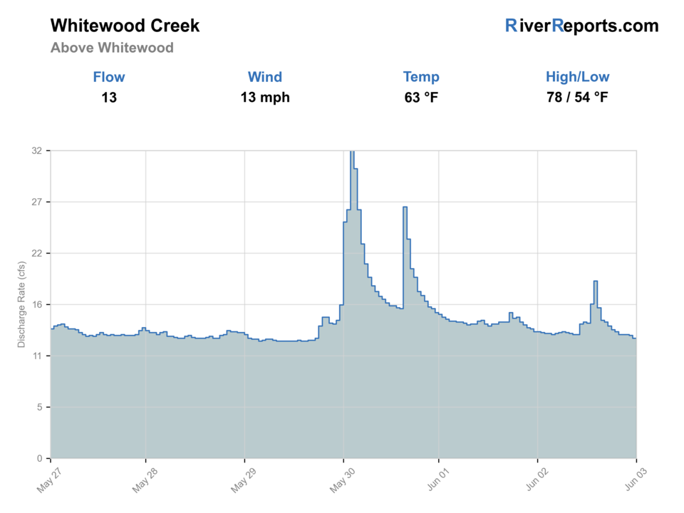
USGS data chart
Official USGS trend
Streamflow over the latest USGS reporting window.
Latest
13 cfs
Jun 3, 4 PM UTC
Weather
River weather report
Weather can change wading safety, road access, water temperature, hatches, and the best time of day to fish.
Live forecast loads as you reach this section
This keeps the report fast while still using the official National Weather Service forecast point.
Hatches and flies
Hatch chart and fly picks
March-May
Blue-winged olives, midges, small stoneflies
BWO nymph, zebra midge, black stonefly
May-June
Caddis and mixed mayflies
Tan caddis pupa, hare's ear, soft hackle
Summer
Caddis, terrestrials, attractor dry windows
Elk hair caddis, parachute Adams, foam ant
Fall
BWOs, midges, streamer windows
RS2, zebra midge, olive bugger
Small nymphs
Pheasant tail, hare's ear, zebra midge, perdigon
The best default for upper Whitewood pockets, runs, and trail-side seams on stable flow.
Dry-dropper
Parachute Adams, elk hair caddis, foam ant with a small nymph
Worth leaning on when clear water and light current make the creek feel settled and fishable at short range.
Micro streamers
Olive bugger, mini leech, sparse black streamer
Useful in darker plunge pockets or when slight color knocks down dry confidence.
Tactics
How to fish it
Start with the public trail corridor and fish the first defined pocket-water sequence before hiking farther.
Keep casts short, use the cover, and let the creek's size dictate a one-pass approach instead of repeat casting over the same lie.
If the upper basin throws color, leave early rather than convincing yourself the next bend will clean up.
Treat the day as a sequence of short controlled checks, not as a mileage contest.
Rigging
Rod, leader, and setup notes
A 3- to 5-weight with floating line is the cleanest fit for the upper Whitewood corridor.
Carry 5X and 6X for nymphs and dry-dropper rigs, with 4X only for small streamers or heavy water.
A compact wading setup and light pack matter more here than extra fly boxes.
Studded or sticky-soled boots help on damp banks, roots, and small rock shelves near the trail corridor.
Access
Access and planning notes
Above-Whitewood gauge
Primary upper-reach trendWade / float / trail
RiverReports / USGS gauge / trout
When to pick it
Start here when upper-basin stability, clarity, and storm response decide the day.
Caution
The gauge does not confirm trail condition, private boundaries, or legal access at every bend.
Deadwood Whitewood Creek Trail
Clearest walk-in public corridorWade / float / trail
Trail / bank / short wade
When to pick it
Use it when you want the most defensible public upper-corridor starting point.
Caution
Stay within public trail access, obey signs, and avoid unsafe slick entries.
Public right-of-way crossings
Short condition checksWade / float / trail
Road crossing / bank / brief wade
When to pick it
Pick only obvious legal crossings when the trail water is too small or crowded.
Caution
If ownership requires guessing, skip the bend.
Keep access anchored to the Deadwood trail corridor, public right-of-way crossings, or verified public land.
If a bend requires guessing about ownership, skip it.
This upper reach is better as a careful walk-in plan than as a roadside improvisation day.
Regulations
Check before fishing
Recheck the 2026 South Dakota Fishing Handbook before fishing because Black Hills trout regulations and seasonal exceptions can change.
Primary base
Deadwood or Whitewood, with a short-session upper-basin trout plan and a lower Whitewood or Spearfish backup
Best day style
Short walk-in trout water from public trail and right-of-way entries, not a full private-valley roam
Check first
RiverReports, USGS 06436180, upper-basin weather, the South Dakota fishing handbook, and Deadwood trail access conditions
Safety
Thunderstorms, slick trail entries, private-land boundaries outside the public corridor, and sudden color changes after rain
Gear
Helpful gear for this water
3- to 5-weight rod
A better fit than a heavier setup for short precise trout casts on smaller upper-basin water.
Compact chest pack
Keeps the trail approach light and makes quick entry-exit decisions easier.
Wading staff or trekking pole
Useful for short steep entries and uneven footing near crossings and trail banks.
Rain shell
Upper Black Hills weather can change faster than the creek looks from the parking area.
Nearby water
Other water to research
Backup logic
Water is colored or rising
Compare Whitewood Creek at Whitewood or Spearfish Creek before forcing upper Whitewood.
Warm trout conditions
Fish early, move colder, or stop trout fishing.
Access is uncertain
Stay on the Deadwood trail corridor or move to a clearer public-access route.
Trail footing is unsafe
Shift bank-first, use a clearer crossing, or pick Spearfish town water.
Whitewood Creek Whitewood
The better move when you want a broader valley reach and a larger public-crossing search radius.
Spearfish Creek Spearfish
A stronger backup when you want a more obvious public in-town trout corridor.
Spearfish Creek
A better choice when you want a fuller trout-day commitment on a larger, more established Black Hills stream.
FAQ
Fast answers
Is Whitewood Creek fishable today?
Whitewood Creek looks very fishable right now. The live score is 96/100, based on current flow, weather, public alerts, and the report's planning context. Recheck the linked gauge and forecast before leaving because conditions can change quickly after rain, heat, access changes, or flow swings.
What flow is best for Whitewood Creek?
Use the above-Whitewood gauge with clarity and upper-basin weather. Stable cool flow is the best signal.
When should I skip Whitewood Creek?
Skip when water is stained, flow is rising, storms are active, legal access is uncertain, water is warm, or trail footing is unsafe.
Is Whitewood Creek safe to wade right now?
The fishability score is not a wading guarantee. Wade only where your chosen access has safe edges, clear footing, legal entry, and no forced crossings; high, rising, stained, or storm-affected water should be treated conservatively.
What flow should I trust for Whitewood Creek above Whitewood?
Use the RiverReports chart for quick reads and keep USGS site 06436180 open as the official upper-corridor backstop.
What makes the upper Whitewood page different from the Whitewood route below town?
This page is built around colder, tighter upper-basin water and the Deadwood trail corridor, while the lower page focuses more on bridge-access valley fishing near Whitewood.
Can I leave the public trail and fish anywhere the creek looks good?
No. South Dakota says Black Hills stream access comes through adjacent-landowner permission or a public right-of-way such as a road crossing or public land.
Sources
Source set for this report
Reviewed 2026-06-02