
South Carolina / Southeast
Chattooga River
A Chattooga River report for anglers planning the South Carolina border corridor around Burrells Ford, Earl's Ford, Forest Service access, flows, and wading judgment.
Image: Generated regional planning image for Chattooga River / BlueStreamFly generated; not exact location / BlueStreamFlyFishability now: Chattooga River fishability today
GreatData confidence: High96/100
Fishable now because the live gauge is falling, weather is usable, and no public alert is active.
Flow observed
5:00 PM UTC
Weather observed
5:00 PM UTC
Score calculated
5:26 PM UTC
Why this rating
Flow
Weather
Public alerts
Next 6-12 hours
Improving / hold
A falling gauge and usable weather should keep the next 6-12 hours in play unless tributaries stain or heat builds.
USGS flow
471 cfs
Current trend: flow falling, rating likely holding strong unless weather or clarity changes.
More planning details: flies, flow bands, and live source checks
Fish it today
Start here
Start with the Clayton gauge, then pick Burrells Ford, Earl's Ford, or a Chattooga River Trail approach before choosing flies.
Best flow clue
Use the Clayton trend with weather and trail conditions. Stable or slowly falling mountain flow is the safest starting point.
Skip trigger
Skip when the river is rising, storms are active, water is warm for trout, the trail plan is too long, or regulation/license boundaries are unclear.
Flow decision bands
Stable mountain trout flow
Stable Clayton flow with cool weather, clear current, and safe crossings is the best signal for Chattooga trout.
Best trail-and-wade window
Mild weather, confirmed access, legal reach clarity, and no thunderstorm threat make the river most fishable.
Rising or stormy
Mountain storms can make crossings, trails, and gorge water dangerous quickly; wait for the trend to settle.
Warm trout water or rule uncertainty
Heat, low warm water, or uncertainty about exact reach rules should move the day to a safer backup.
USGS flow
471 cfs
Current trend: flow falling, rating likely holding strong unless weather or clarity changes.
Live USGS flow
471 cfs / falling about 18%
Live NWS forecast
73F / Sunny
Water temperature not verified
Heat guidance uses weather and river type unless an official water-temperature value is available.
No NWS alert flag
No active NWS alert was returned for this forecast point.
The Forest Service says the Chattooga runs 57 miles through North Carolina, South Carolina, and Georgia and includes a Wild and Scenic river corridor with wilderness water.
Forest Service boating guidance says the Greens Creek to Burrells Ford section is only open to boating from December 1 through April 30 at 350 cfs and above during daylight hours, which is a useful reminder that current matters here.
South Carolina trout resources and stocking summaries still treat the Chattooga as a core mountain-trout water, but the river is broad enough that public access and safe wading matter more than chasing the latest stocking rumor.
The easiest entries draw the most pressure, so a short disciplined session often beats a long hike with no clear exit plan.
Editorial review
How this report is maintained
This report starts with official regulation, access, flow, weather, and public-land sources, then adds practical planning guidance for fly anglers.
Byline
BlueStreamFly editorial desk
Reviewed by
BlueStreamFly source review
Maintained by
BlueStreamFly
Last material review
2026-06-02
Report confidence
Good confidence
89/100
Good confidence: RiverReports, USGS Clayton flow, Forest Service Wild and Scenic and trail sources, SCDNR fishing, trout-stocking, and trout-guide sources, weather coverage, image disclosure, and route-specific mountain-trout guidance support the page. Confidence is moderated by state-line rules, trail distance, rapid storm response, summer heat, and reach-specific access details.
Regulations
SCDNR fishing, trout-stocking, and trout-guide sources support the South Carolina rule-check path, with state-line and federal-corridor verification retained.
Access
Forest Service Wild and Scenic and trail sources support Burrells Ford, Earl's Ford, and trail-based planning.
Flow and weather
RiverReports coverage is backed by USGS 02177000 near Clayton, and the National Weather Service point supports mountain storm and heat decisions.
Fishing usefulness
The page now separates Clayton flow, Burrells Ford access, trail mileage, trout heat risk, storm safety, state-line rules, and backup-water choices.
Fishability dashboard and source review
2026-06-02 / material content or source review
RiverReports, USGS 02177000 near Clayton, Forest Service Chattooga Wild and Scenic River and trail sources, SCDNR fishing, trout-stocking, and trout-guide sources, image-disclosure, and National Weather Service sources were checked before updating the current-fishability decision layer.
2026-06-02
Updated Chattooga River to the current fishability-page standard with Clayton trend bands, Burrells Ford and trail access cards, wild-and-scenic safety cues, stable fishability SEO, and confidence signals.
2026-05-26
Published a new Chattooga River report with access-focused planning, Forest Service safety context, and mountain-river wading guidance.
Angler planning edge
Local details that change the plan
Best for
Wild and Scenic trout water, Burrells Ford and Earl's Ford sessions, cool mountain wade-and-hike days
Wade or float
Wade and hike from official corridor access; treat boating, whitewater, and long trail plans as separate safety decisions.
Best flows
Use the Clayton trend with weather and trail conditions. Stable or slowly falling mountain flow is the safest starting point.
When to skip
Skip when the river is rising, storms are active, water is warm for trout, the trail plan is too long, or regulation/license boundaries are unclear.
Local plan
Start with the Clayton gauge, then pick Burrells Ford, Earl's Ford, or a Chattooga River Trail approach before choosing flies.
Pressure
Classic access points can be busy; trail mileage often creates better spacing than forcing the first pool.
Access nuance
The Wild and Scenic corridor crosses public-land and state-line complexity, so anglers should verify the exact reach rules before fishing.
Backup water
Compare Davidson River, Nantahala River, or Tuckasegee River when the Chattooga is high, hot, stormy, or access-limited.
About the river
Setting, character, and why it fishes the way it does.
The Chattooga is a true mountain-border river, not a roadside park stream. That changes how you should plan it. Access can mean a trail, a ford, or a long walk back to the truck, so the page stays focused on the South Carolina-side access corridor most anglers can actually fish in a day.
Forest Service management also matters more here than on many southeastern trout rivers because so much of the public water sits inside a federal corridor with wilderness character, boat-use rules, and trail-based entry points.
This is also not a one-speed trout stream. Pocket water, slick ledge, soft inside seams, and bouldery slots can all show up within one reach, which is why flow trend and wading judgment decide more than fly choice.
Target species
Rainbow trout
A common target in the public mountain corridor, especially in cooler flow and hatch windows.
Brown trout
Worth watching around boulders, wood, and lower-light streamer conditions.
Brook trout
More realistic in colder tributary or upper-small-water context than across every main-stem reach.
Smallmouth bass
Relevant lower in the system and during warm-season shifts away from a strict trout plan.
Reading the water
Stable moderate flow
Best window for pocket-water nymphing, dry-dropper rigs, and safe edge wading.
Low clear water
Lengthen leaders, fish early and late, and approach obvious pools carefully.
Rising after rain
Stick to soft banks and obvious exits or wait it out; the Chattooga gets serious quickly.
Cold pushy winter water
Shrink the river, fish slower pockets, and avoid long wades that depend on perfect footing.
Best seasons
Spring
A strong window for classic mountain-trout fishing when flows settle and insect activity builds.
Early summer
Good for dry-dropper and caddis-style fishing before heat and thunderstorm spikes become the main story.
Late summer
Fish early, watch temperature, and stay realistic about pressure on the easiest public entries.
Fall
Cooling water and steadier weather often make this one of the most balanced seasons for wading and streamer work.
Preferred flow source
Chattooga River near Clayton
RiverReports is the preferred chart source when coverage exists. When a matching USGS gauge exists, keep it open as the official backstop for station data and current hydrograph context.
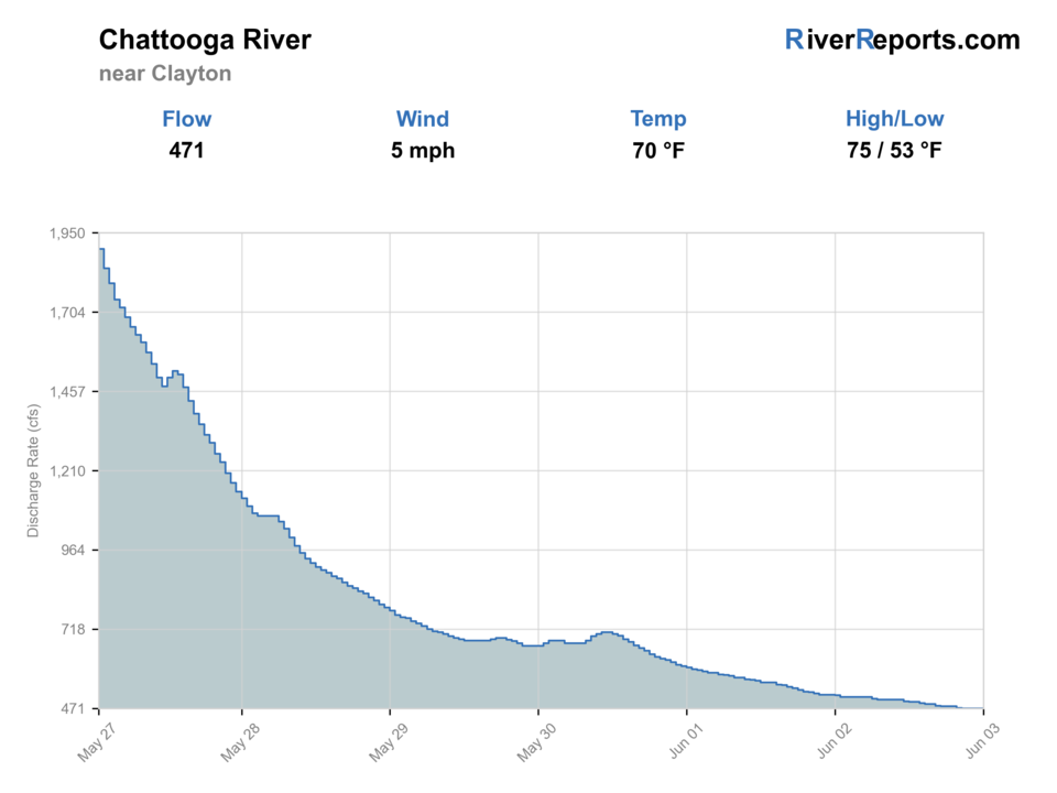
USGS data chart
Official USGS trend
Streamflow over the latest USGS reporting window.
Latest
471 cfs
Jun 3, 5 PM UTC
Weather
River weather report
Weather can change wading safety, road access, water temperature, hatches, and the best time of day to fish.
Live forecast loads as you reach this section
This keeps the report fast while still using the official National Weather Service forecast point.
Hatches and flies
Hatch chart and fly picks
March-April
Blue-winged olives, little black stones, early caddis
BWO emerger, black stonefly nymph, elk hair caddis
April-June
March browns, caddis, yellow sallies
March brown dry, soft hackle, yellow stimulator, hare's ear
June-August
Caddis, terrestrials, attractor windows
Foam ant, beetle, caddis pupa, yellow dry-dropper
September-November
BWOs, midges, baitfish windows
Small BWO, zebra midge, olive bugger, small sculpin
Nymphs
Pheasant tail, hare's ear, perdigon, stonefly nymph
Start here when the river is fishable but no obvious hatch is showing.
Dry-dropper
Yellow stimulator, parachute Adams, caddis dry, small dropper
Best for covering pocket water and broken current in stable summer flow.
Streamers
Olive bugger, black bugger, small sculpin
Use on stained edges, lower light, or whenever bigger fish hug structure.
Tactics
How to fish it
Pick one access point and fish it thoroughly instead of burning time on repeated trail moves.
On moderate flow, work the first soft seam next to boulders, ledge pockets, and inside current breaks before stepping deeper.
If the river is pushy, fish from the bank or a short wade only. The Chattooga is not the place to force a crossing because the next run looks good.
Carry enough split shot to touch the lower seam a few times per drift, then lighten up quickly when fish slide higher in broken current.
Rigging
Rod, leader, and setup notes
A 9-foot 4- or 5-weight covers most trout days and still handles a small streamer.
Carry 4X through 6X tippet for nymphs, dry-dropper rigs, and hatch work, with 3X available for streamers.
A short indicator setup is usually easier to manage here than a long high-stick rig once wind and pocket water mix together.
A wading staff and sticky-soled boots matter more on this river than an extra fly box.
Access
Access and planning notes
Clayton gauge
Primary mountain-flow checkWade / float / trail
RiverReports / USGS gauge / trout safety
When to pick it
Start here when rising water, crossings, and trail safety decide the plan.
Caution
The gauge does not replace local trail, storm, license, or reach-specific regulation checks.
Burrells Ford and Earl's Ford
Classic public accessWade / float / trail
Forest corridor / wade / hike
When to pick it
Use these when you want the most recognizable public starts in the trout corridor.
Caution
Expect trail effort, slick rocks, crowds near the first pools, and state-line rule complexity.
Chattooga River Trail
Walk into quieter waterWade / float / trail
Trail / wade / hike
When to pick it
Pick it when conditions are stable and you are prepared for the return hike.
Caution
Do not commit to long trail water during thunderstorms, high water, or heat-stress windows.
Use only signed public access and Forest Service trailheads.
The most popular accesses fish fine, but they also collect the most pressure and the fastest parking turnover.
Trail access can make the river feel smaller on the walk in and much bigger on the walk out. Leave enough margin for the return.
Regulations
Check before fishing
South Carolina freshwater rules apply on South Carolina water, but the Chattooga also touches Georgia and federal land management. Recheck current trout regulations, license requirements, and any access notices before fishing your exact reach.
Primary base
Long Creek, Mountain Rest, Clayton, or a focused day trip from the Upstate
Best day style
Forest Service trailheads, walk-in access, and wade-first planning with remote-river caution
Check first
RiverReports, USGS 02177000, Forest Service access pages, South Carolina trout resources, and the NWS forecast
Safety
Fast current, slick ledge rock, remote trail exits, mountain weather, and long wades with no easy bailout
Gear
Helpful gear for this water
4- or 5-weight rod
Best all-around choice for dry-dropper, nymph, and light streamer fishing.
Wading staff
A real safety item here, not optional gear decoration.
Sticky-soled boots
Helpful on algae-slick rock and uneven ledge.
Compact day pack
Carry water, layers, and enough food for a trail-access day instead of overloading the hike.
Nearby water
Other water to research
Backup logic
High or rising water
Compare Davidson River or Nantahala River before forcing dangerous crossings.
Warm trout conditions
Fish early, move higher/cooler, or leave trout alone for a cooler window.
Trail or weather risk
Use a shorter official access or pick a river with easier exits.
Reach-rule uncertainty
Confirm South Carolina, Georgia, and federal corridor rules before fishing.
Davidson River
A clearer and more technical western North Carolina trout option.
Nantahala River
A colder release-driven trout backup when the freestone is blown out.
Tuckasegee River
A more access-friendly western Carolina trout option when you want easier public entries.
FAQ
Fast answers
Is Chattooga River fishable today?
Chattooga River looks very fishable right now. The live score is 96/100, based on current flow, weather, public alerts, and the report's planning context. Recheck the linked gauge and forecast before leaving because conditions can change quickly after rain, heat, access changes, or flow swings.
What flow is best for Chattooga River?
Use the Clayton trend with weather and trail conditions. Stable or slowly falling mountain flow is the safest starting point.
When should I skip Chattooga River?
Skip when the river is rising, storms are active, water is warm for trout, the trail plan is too long, or regulation/license boundaries are unclear.
Is Chattooga River safe to wade right now?
The fishability score is not a wading guarantee. Wade only where your chosen access has safe edges, clear footing, legal entry, and no forced crossings; high, rising, stained, or storm-affected water should be treated conservatively.
What gauge should I check for the Chattooga River?
Start with RiverReports for the quick chart and use USGS 02177000 near Clayton as the official flow reference behind the report.
Is the Chattooga a good beginner trout river?
Only in moderation. The fish are approachable, but current, footing, and trail exits can punish bad decisions faster than on easier roadside trout water.
Can I float this South Carolina Chattooga reach?
The Forest Service posts specific seasonal and daylight boating rules for part of the corridor. Check the current federal guidance before treating a float idea as legal or safe.
Sources
Source set for this report
Reviewed 2026-06-02