
Pennsylvania / Northeast
Slippery Rock Creek
A western Pennsylvania gorge report for anglers planning Slippery Rock Creek around the Wurtemburg gauge, Armstrong Bridge fly water, and steep-gorge safety.
Image: Generated regional planning image for Slippery Rock Creek / BlueStreamFly generated; not exact location / BlueStreamFlyFishability now: Slippery Rock Creek fishability today
GreatData confidence: High96/100
Fishable now because Wurtemburg gauge is falling, weather is usable, and no public alert is active.
Flow observed
4:30 PM UTC
Weather observed
5:00 PM UTC
Score calculated
5:26 PM UTC
Why this rating
Flow
Weather
Public alerts
Next 6-12 hours
Improving / hold
A falling gauge and usable weather should keep the next 6-12 hours in play unless tributaries stain or heat builds.
USGS flow
375 cfs
Current trend: flow falling, rating likely holding strong unless weather or clarity changes.
More planning details: flies, flow bands, and live source checks
Fish it today
Start here
Start with the Wurtemburg gauge, then pick Armstrong Bridge trout water only if flow, footing, and current Pennsylvania rules line up.
Best flow clue
Use the Wurtemburg trend more than a fixed number. Stable or slowly falling, clear edge water is the most useful signal.
Skip trigger
Skip or scale back when the creek is rising, stained, whitewater-heavy, slick at entries, too warm for trout, or crowded at bridge water.
Flow decision bands
Moderate and clear
Stable or slowly falling Wurtemburg flow with visible edge water is the best setup for Armstrong Bridge trout water and careful mixed-water seams.
Best gorge window
Readable current, mild weather, clear exits, and a conservative entry point make the creek most fishable.
Whitewater, stained, or slick
High flow, rain stain, rapids, slick rock, or poor exits should move the plan to bank scouting or another river.
Warm or pressure-shifted
Summer warmth, crowded bridge water, or trout-stress conditions should shift the plan toward bass, edges, or a colder backup.
USGS flow
375 cfs
Current trend: flow falling, rating likely holding strong unless weather or clarity changes.
Live USGS flow
375 cfs / falling about 20%
Live NWS forecast
77F / Sunny
Water temperature not verified
Heat guidance uses weather and river type unless an official water-temperature value is available.
No NWS alert flag
No active NWS alert was returned for this forecast point.
Use RiverReports for the fast chart and USGS 03106500 at Wurtemburg for the official gauge reference.
DCNR says fishing is allowed anywhere along Slippery Rock Creek in the park except the dam structures, and identifies a fly-fishing-only, catch-and-release area by Armstrong Bridge.
The park also warns that the gorge holds smooth slippery rocks, deep pools, rapids, swift current, and a real history of serious accidents.
This is a trout-and-bass creek. Fly anglers usually do best by choosing one access and fishing it carefully instead of trying to force a full-gorge tour.
Editorial review
How this report is maintained
This report starts with official regulation, access, flow, weather, and public-land sources, then adds practical planning guidance for fly anglers.
Byline
BlueStreamFly editorial desk
Reviewed by
BlueStreamFly source review
Maintained by
BlueStreamFly
Last material review
2026-06-02
Report confidence
Good confidence
88/100
Good confidence: RiverReports, USGS Wurtemburg flow, Pennsylvania regulation sources, McConnells Mill fishing, map, whitewater, and park sources, weather coverage, image disclosure, and route-specific gorge guidance support the page. Confidence is moderated by fast gorge hazards, slick rock, bridge pressure, warm-water shifts, and the generated regional image.
Regulations
Pennsylvania regulations and McConnells Mill fishing guidance support the current rule-check path, including the Armstrong Bridge fly-fishing-only context.
Access
DCNR McConnells Mill access, park, whitewater, and map sources support the public corridor and safety framework.
Flow and weather
RiverReports coverage is backed by USGS 03106500 at Wurtemburg, and the National Weather Service point supports storm and weather decisions.
Fishing usefulness
The page now separates trout reach choice, gorge flow risk, slick-rock safety, warmwater pivots, pressure, and backup-water choices.
Fishability dashboard and source review
2026-06-02 / material content or source review
RiverReports, USGS 03106500 at Wurtemburg, Pennsylvania regulations, McConnells Mill fishing, overview, whitewater, park-map, image-disclosure, and National Weather Service sources were checked before updating the current-fishability decision layer.
2026-06-02
Updated Slippery Rock Creek to the current fishability-page standard with Wurtemburg trend bands, McConnells Mill access cards, gorge-safety backup cues, stable fishability SEO, and confidence signals.
2026-05-26
Published a new Slippery Rock Creek report with Armstrong Bridge trout guidance, gorge hazard warnings, and bridge-based access planning.
Angler planning edge
Local details that change the plan
Best for
Careful gorge trout sessions, mixed-water edge fishing, short public-access scouting
Wade or float
Mostly wade, bank, or scout. Treat higher gorge flows as whitewater context, not casual trout-wading water.
Best flows
Use the Wurtemburg trend more than a fixed number. Stable or slowly falling, clear edge water is the most useful signal.
When to skip
Skip or scale back when the creek is rising, stained, whitewater-heavy, slick at entries, too warm for trout, or crowded at bridge water.
Local plan
Start with the Wurtemburg gauge, then pick Armstrong Bridge trout water only if flow, footing, and current Pennsylvania rules line up.
Pressure
Armstrong Bridge and obvious park water concentrate pressure; less obvious public water still needs safe access and posted-sign checks.
Access nuance
McConnells Mill has real public access, but steep banks, slick rock, rapids, and private edges can be the limiting factor.
Backup water
Compare Oil Creek, Kettle Creek, or Spring Creek when Slippery Rock is high, stained, warm, or unsafe to enter.
About the river
Setting, character, and why it fishes the way it does.
McConnells Mill State Park sits in a National Natural Landmark gorge carved by glacial drainage, with steep walls, huge boulders, and a historic mill corridor. Those landscape features define the fishing just as much as the trout and bass do.
The creek supports both coldwater and warmwater species, and DCNR says sections are stocked with trout by the Pennsylvania Fish and Boat Commission. That mixed profile is why the page works best as a seasonal planning report instead of a one-style trout promise.
Fly anglers should think of Slippery Rock as a corridor of distinct decision points: Armstrong Bridge for regulation-focused trout fishing, bridge and trail access for short sessions, and whitewater-influenced reaches where safety matters more than forcing a cast count.
Target species
Brown trout
A realistic target in cooler periods and stocked or holdover-friendly sections.
Rainbow trout
Relevant where PFBC stocking supports the park fishery.
Smallmouth bass
A strong warm-season fallback in the broader gorge and downstream water.
Panfish and other warmwater species
More important when summer temperatures reduce trout opportunity.
Reading the water
Moderate clear flow
Best for controlled wading near public access, nymphs through seams, and short streamer swings.
Low clear water
Use stealth, fish mornings or evenings, and stay honest about fish pressure.
Whitewater push
Treat as a no-wade day unless you are staying on the bank in a safe accessible section.
Warm summer water
Shift toward bass or another trout option if temperature and handling risk climb.
Best seasons
Spring
Good trout and mixed-species opportunity when water settles between rain events.
Early summer
Still useful for trout in cooler windows, with bass becoming more relevant as heat builds.
Mid to late summer
Best for early or late bass-focused sessions unless cool weather keeps trout water in shape.
Fall
A strong reset for both trout and bass once temperatures drop and flows stabilize.
Preferred flow source
Slippery Rock Creek at Wurtemburg
RiverReports is the preferred chart source when coverage exists. When a matching USGS gauge exists, keep it open as the official backstop for station data and current hydrograph context.
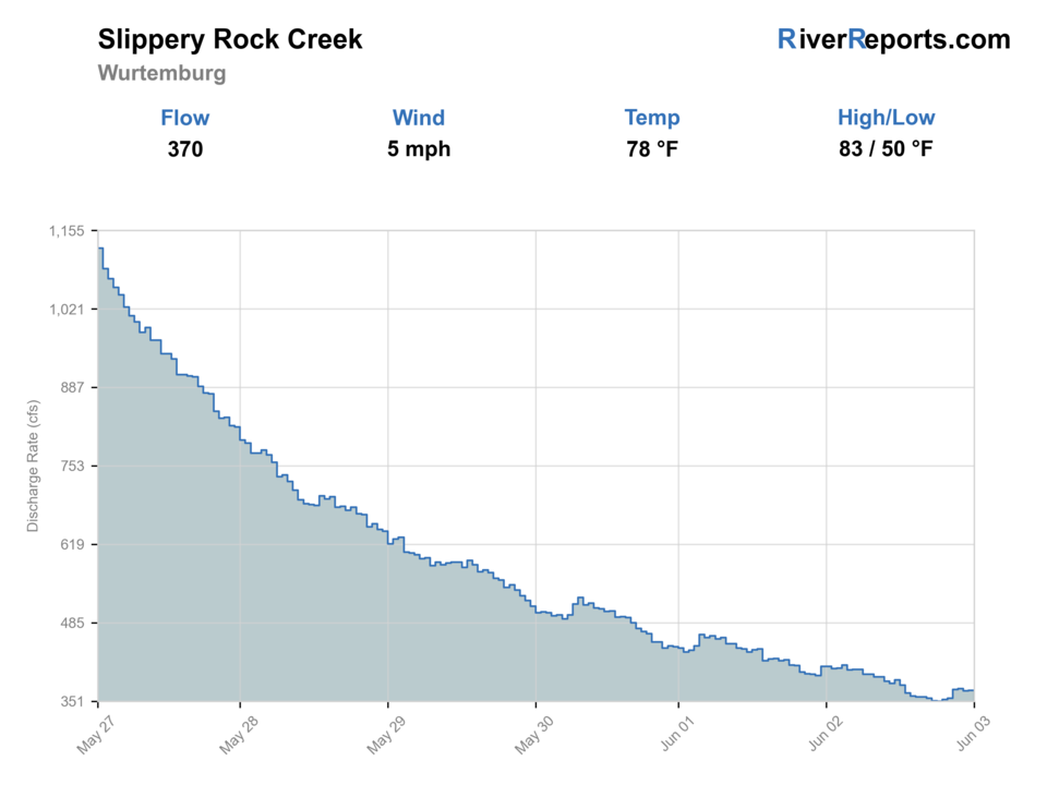
USGS data chart
Official USGS trend
Streamflow over the latest USGS reporting window.
Latest
375 cfs
Jun 3, 4 PM UTC
Weather
River weather report
Weather can change wading safety, road access, water temperature, hatches, and the best time of day to fish.
Live forecast loads as you reach this section
This keeps the report fast while still using the official National Weather Service forecast point.
Hatches and flies
Hatch chart and fly picks
March-April
Midges, BWOs, early stones
Midge pupa, pheasant tail, black stone, BWO emerger
April-June
Caddis, March brown-style mayflies, Hendrickson-style mayflies
Elk hair caddis, March Brown, hare's ear, soft hackle
July-August
Terrestrials, caddis, warmwater baitfish windows
Foam ant, beetle, bugger, small baitfish streamer
September-October
Caddis, olives, streamer conditions
BWO dry, caddis pupa, olive bugger, leech
Trout nymphs
Pheasant tail, hare's ear, stonefly nymph, perdigon
You can safely reach seams around the fly-only or bridge-accessed water.
Drys and wets
Elk hair caddis, parachute Adams, soft hackles, foam ant
Fish rise in softer current or you are prospecting broken pocket water.
Bass and mixed-water streamers
Olive bugger, black bugger, small baitfish, crayfish pattern
Summer warmth or stained water turns the day toward bass.
Tactics
How to fish it
Pick one access point and fish it well. The creek fishes better when you stop chasing the whole gorge and match your rig to one safe entry.
Use the Armstrong Bridge fly-only water when you want the clearest trout-focused plan. Elsewhere, treat trout and bass as coexisting options rather than forcing one species story.
If the current is pushy, fish from the bank, work softer inside edges, and do not wade just because the run looks reachable.
A short nymph rig or soft-hackle swing usually makes more sense than long drifts in this broken, hazard-heavy water.
Rigging
Rod, leader, and setup notes
A 4- or 5-weight covers trout work, while a 6-weight is useful if you expect more streamer or bass time.
Carry 4X through 6X for trout, plus 3X for streamers.
Use compact indicators or tight-line style rigs where casting room is limited by trees, boulders, or steep banks.
Studded boots and a wading staff are worth carrying, but they do not turn unsafe whitewater into a wading day.
Access
Access and planning notes
Wurtemburg gauge
Primary gorge trendWade / float / trail
RiverReports / USGS gauge / wade caution
When to pick it
Start here when flow direction and wading margin decide whether the gorge is worth fishing.
Caution
The gauge does not make slick rocks, rapids, deep pools, or steep exits safe.
Armstrong Bridge fly water
Trout-specific planWade / float / trail
Wade / bank / fly-only reach
When to pick it
Use it when Pennsylvania rules, flow, and safe entry all support a focused trout session.
Caution
Bridge access concentrates pressure and still needs current rule and footing checks.
McConnells Mill gorge corridor
Public access and safety checkWade / float / trail
Park / trail / bank
When to pick it
Pick this when park access and whitewater context determine whether to fish, scout, or leave.
Caution
Park access is real, but the terrain is often the limiting factor.
The park map marks the catch-and-release fly-fishing-only stretch and the main bridge access points; use it before you leave cell service.
Some of the best-looking water sits below steep trails and polished rock. If you are questioning the entry, that is the answer.
Boaters must portage the dam and should never run it. Anglers should give that hazard plenty of room too.
This gorge is a poor place to discover after dark that your exit trail is longer than expected.
Regulations
Check before fishing
Pennsylvania Fish and Boat Commission regulations apply. Recheck current trout rules, permits, and any special regulations before fishing the Armstrong Bridge section or any stocked water.
Primary base
Portersville, Wurtemburg, or a quick day trip from western Pennsylvania
Best day style
Bridge-based public access, steep gorge paths, and selective wading only when the level and entry both look right
Check first
RiverReports, USGS 03106500, Pennsylvania regulations, McConnells Mill access pages, and NWS weather
Safety
Steep gorge walls, polished rocks, deep pools, rapids, whitewater, poor phone signal, and long walk-outs
Gear
Helpful gear for this water
Wading staff
One of the few pieces of gear that can genuinely save the day here.
Studded boots or strong traction
Useful because the gorge is exactly as slippery as the name suggests.
Compact chest pack
Better than a bulky setup on steep trails and rocky banks.
Headlamp and charged phone
Important when trail exits, weather, or timing do not go to plan.
Nearby water
Other water to research
Backup logic
High or stained water
Compare Oil Creek, Kettle Creek, or Spring Creek instead of forcing the gorge.
Warm trout conditions
Switch to bass water, fish only the coolest responsible window, or choose colder trout water.
Unsafe entry
Stay on the bank or leave; traction gear does not turn whitewater into a wade day.
Crowded bridge water
Use another clearly public access or pick a less concentrated western Pennsylvania option.
Oil Creek
A more structured park-access option with delayed-harvest trout water and gentler scouting.
Kettle Creek
A colder-feeling freestone alternative when you want less gorge hazard.
Spring Creek
A steadier limestone fallback when weather and runoff punish freestones.
FAQ
Fast answers
Is Slippery Rock Creek fishable today?
Slippery Rock Creek looks very fishable right now. The live score is 96/100, based on current flow, weather, public alerts, and the report's planning context. Recheck the linked gauge and forecast before leaving because conditions can change quickly after rain, heat, access changes, or flow swings.
What flow is best for Slippery Rock Creek?
Use the Wurtemburg trend more than a fixed number. Stable or slowly falling, clear edge water is the most useful signal.
When should I skip Slippery Rock Creek?
Skip or scale back when the creek is rising, stained, whitewater-heavy, slick at entries, too warm for trout, or crowded at bridge water.
Is Slippery Rock Creek safe to wade right now?
The fishability score is not a wading guarantee. Wade only where your chosen access has safe edges, clear footing, legal entry, and no forced crossings; high, rising, stained, or storm-affected water should be treated conservatively.
What gauge should I use for Slippery Rock Creek?
Use RiverReports for the quick chart and USGS 03106500 at Wurtemburg for the official flow reference.
Where is the fly-only section?
DCNR identifies a fly-fishing-only, catch-and-release area by Armstrong Bridge inside McConnells Mill State Park.
Is Slippery Rock Creek safe to wade?
Only at conservative levels and only in access points you have already judged carefully. The park warns about smooth slippery rocks, deep pools, rapids, and swift current, and serious accidents have happened here.
Sources
Source set for this report
Reviewed 2026-06-02