
Pennsylvania / Northeast
Oil Creek
A northwestern Pennsylvania report for anglers planning Oil Creek around delayed-harvest water, state-park access, flows, and warm-versus-cool-water timing.
Image: Generated regional planning image for Oil Creek / BlueStreamFly generated; not exact location / BlueStreamFlyFishability now: Oil Creek fishability today
GreatData confidence: High96/100
Fishable now because Rouseville gauge is falling, weather is usable, and no public alert is active.
Flow observed
4:45 PM UTC
Weather observed
5:00 PM UTC
Score calculated
5:26 PM UTC
Why this rating
Flow
Weather
Public alerts
Next 6-12 hours
Improving / hold
A falling gauge and usable weather should keep the next 6-12 hours in play unless tributaries stain or heat builds.
USGS flow
223 cfs
Current trend: flow falling, rating likely holding strong unless weather or clarity changes.
More planning details: flies, flow bands, and live source checks
Fish it today
Start here
Base near Oil City, Titusville, or Petroleum Centre, check the Rouseville gauge, then decide between delayed-harvest trout water and a bass-oriented backup.
Best flow clue
Stable or gently dropping levels that leave enough edge and clarity for nymphs and dry-droppers without pushing you off the bank.
Skip trigger
Skip trout fishing in warm summer water, after muddy rain spikes, or when current is high enough that you are guessing at exits.
Flow decision bands
Stable Rouseville flow
Stable or slowly falling 03020500 flow with workable clarity is the best trout-and-bass signal.
Delayed-harvest trout window
Cool water and moderate flow make the park's delayed-harvest sections the first trout check.
High or floatable
A level that works for permitted boats can still be a poor and unsafe wading setup.
Warm summer pivot
Warm low water should push the plan toward bass, tributary scouting, or no trout handling.
USGS flow
223 cfs
Current trend: flow falling, rating likely holding strong unless weather or clarity changes.
Live USGS flow
223 cfs / falling about 21%
Live NWS forecast
76F / Sunny
Water temperature not verified
Heat guidance uses weather and river type unless an official water-temperature value is available.
No NWS alert flag
No active NWS alert was returned for this forecast point.
RiverReports gives the quick chart and USGS 03020500 at Rouseville is the official flow backstop.
DCNR says Oil Creek State Park has two delayed-harvest, artificial-lures-only sections covering 2.5 miles of creek.
Brook trout tributaries like Boughton Run, Toy Run, and Jones Run make good backup scouting water when the main creek is warm or pushy.
Oil Creek can be a beginner-friendly float at the right level, but DCNR warns that water levels can change rapidly and gives clear level thresholds for boating decisions.
Editorial review
How this report is maintained
This report starts with official regulation, access, flow, weather, and public-land sources, then adds practical planning guidance for fly anglers.
Byline
BlueStreamFly editorial desk
Reviewed by
BlueStreamFly source review
Maintained by
BlueStreamFly
Last material review
2026-06-02
Report confidence
Good confidence
88/100
Good confidence: PFBC regulation sources, Oil Creek State Park fishing, access, history, and boating pages, RiverReports and USGS 03020500 flow, weather coverage, generated media disclosure, and route-specific Oil Creek guidance support the page. Confidence is moderated by rapid level changes, temperature-sensitive trout water, float-versus-wade differences, posted access, and mixed-species seasonality.
Regulations
PFBC fishing regulation sources support Pennsylvania trout, permit, and delayed-harvest rule checks.
Access
Oil Creek State Park fishing and overview pages provide a strong public access framework, with posted areas, day-use timing, tributaries, and float permits still needing checks.
Flow and weather
RiverReports, USGS 03020500 at Rouseville, and the National Weather Service point support live flow and weather decisions.
Fishing usefulness
The page now separates delayed-harvest trout planning, mixed-species backup, float thresholds, warm-water restraint, park access, and backup-water choices.
Fishability dashboard and source review
2026-06-02 / material content or source review
PFBC fishing regulation sources, Oil Creek State Park fishing, overview, history, and boating pages, RiverReports and USGS 03020500 flow, National Weather Service data, and generated-image disclosure were checked before updating the current-fishability decision layer.
2026-06-02
Updated Oil Creek to the current fishability-page standard with Rouseville flow bands, delayed-harvest and state-park access cards, backup cues, stable fishability SEO, and confidence signals.
2026-05-26
Published a new Oil Creek report with delayed-harvest planning, park access notes, temperature guidance, and mixed-species backup advice.
Angler planning edge
Local details that change the plan
Best for
Park-access trout planning, Beginner-friendly mixed trout and bass trips, Spring and fall walk-and-wade days
Wade or float
Wade first. Short floats make sense only when level, permit, and shuttle logistics are already lined up.
Best flows
Stable or gently dropping levels that leave enough edge and clarity for nymphs and dry-droppers without pushing you off the bank.
When to skip
Skip trout fishing in warm summer water, after muddy rain spikes, or when current is high enough that you are guessing at exits.
Local plan
Base near Oil City, Titusville, or Petroleum Centre, check the Rouseville gauge, then decide between delayed-harvest trout water and a bass-oriented backup.
Pressure
Expect the easiest public sections to see the most pressure, especially around stocked water and bike-trail-adjacent access.
Access nuance
The state park gives you a real public corridor, but tributary and roadside moves still require posted-access discipline.
Backup water
Kettle Creek is the colder trout backup, while Slippery Rock Creek is the western Pennsylvania alternative when you want a different regulation mix.
About the river
Setting, character, and why it fishes the way it does.
Oil Creek runs through the valley where the modern petroleum industry started, and the park still interprets boomtown history, wells, and transportation routes around the water. That makes it a fishing page with real access structure instead of a vague map-dot river.
DCNR describes the park as a steep-hollow gorge corridor between Titusville and Oil City. For fly anglers that means easy parking and bike-path visibility in some sections, but more confined banks and quicker water in others.
This is also a mixed fishery page. Trout matter most in the delayed-harvest sections and cold tributary context, while bass and warmwater fishing become more realistic lower in the season and farther from the coldest tributary influence.
Target species
Brown trout
A practical target in delayed-harvest water and cooler shoulder-season conditions.
Rainbow trout
Relevant where PFBC management and seasonal stocking support the delayed-harvest plan.
Brook trout
Most important in the tributary backup water called out by the state park.
Smallmouth bass
A better warm-season fallback when trout water temperatures stop making sense.
Reading the water
Moderate and clear
Best for covering delayed-harvest runs with nymphs, caddis, and small streamers.
Low summer flow
Fish early, monitor temperature, and shift toward bass or tributary scouting if trout water warms.
Rising after rain
Hold off on wading and let clarity return before forcing the day.
High floatable level
Useful for boaters with the right permits and skill, but often a poor wading setup.
Best seasons
Early spring
Good for nymphing and streamer days when levels settle and stocking windows line up.
Late spring to early summer
Usually the strongest trout window for delayed-harvest structure, caddis, and mixed hatch activity.
Mid to late summer
Shift to early starts and let water temperature decide whether trout or bass is the responsible plan.
Fall
Strong for mixed-species fishing and trout-friendly temperatures once flows stabilize again.
Preferred flow source
Oil Creek at Rouseville
RiverReports is the preferred chart source when coverage exists. When a matching USGS gauge exists, keep it open as the official backstop for station data and current hydrograph context.
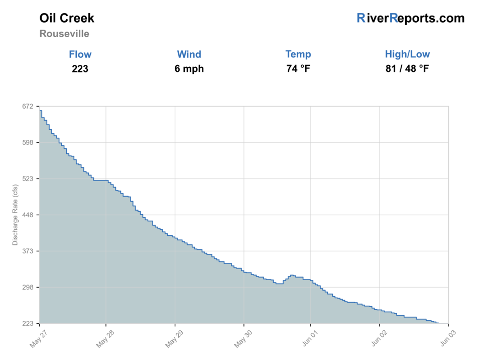
USGS data chart
Official USGS trend
Streamflow over the latest USGS reporting window.
Latest
223 cfs
Jun 3, 4 PM UTC
Weather
River weather report
Weather can change wading safety, road access, water temperature, hatches, and the best time of day to fish.
Live forecast loads as you reach this section
This keeps the report fast while still using the official National Weather Service forecast point.
Hatches and flies
Hatch chart and fly picks
March-April
Midges, early black stones, BWOs
Zebra midge, pheasant tail, black stone, BWO emerger
April-June
Caddis, Hendrickson-style mayflies, March brown-style mayflies
Elk hair caddis, soft hackle, hare's ear, parachute Adams
July-August
Terrestrials, caddis, small mayflies
Foam ant, beetle, caddis pupa, small olive bugger
September-October
Caddis, BWOs, baitfish windows
BWO comparadun, soft hackle, woolly bugger, small sculpin
Nymphs
Pheasant tail, hare's ear, perdigon, caddis pupa
Water is moderate and you need to cover seams in delayed-harvest runs.
Dries and wets
Elk hair caddis, parachute Adams, ant, beetle, soft hackles
Fish rise in softer current or caddis activity starts to show.
Small streamers
Olive bugger, black bugger, small sculpin
Water has color, trout are hugging banks, or you pivot toward bass.
Tactics
How to fish it
Split the creek into two plans: delayed-harvest trout water when temperatures and clarity cooperate, or broader mixed-species water when summer warmth pushes trout management into the background.
Use the Rouseville gauge first, then confirm whether your chosen access has enough room for a safe entry and exit. Oil Creek fishes smaller than some of its drainage numbers suggest once banks tighten up.
A dry-dropper or light two-fly nymph rig covers most productive water. Save streamers for stained water, lower light, or bass-oriented stretches.
If the main stem is too warm, too high, or too crowded, scout the park's named brook-trout tributaries only where access and posted rules are clear.
Rigging
Rod, leader, and setup notes
A 4- or 5-weight handles most trout work, while a 6-weight becomes useful if you expect streamers or more bass time.
Carry 4X through 6X for trout and 3X for streamer or bass adjustments.
Use enough weight to touch the lower seam a few times per drift, but avoid constant ticking in the slower delayed-harvest buckets.
For short floats, keep gear simple and protect dry storage; the creek is easier to manage with a compact kit than a raft-sized loadout.
Access
Access and planning notes
Rouseville gauge
Primary flow and trend checkWade / float / trail
RiverReports / USGS gauge
When to pick it
Start here before deciding whether the day is delayed-harvest trout, bass, float, or skip.
Caution
Flow does not confirm temperature, clarity, or safe exits at a chosen park access.
Oil Creek State Park corridor
Public trout and mixed-water baseWade / float / trail
State park / wade / bank
When to pick it
Use this when sunrise-to-sunset park access and moderate flow support a compact session.
Caution
Day-use hours, posted areas, and rapidly changing levels still matter.
Petroleum Centre and day-use areas
Short access planWade / float / trail
Park pullout / trail / wade
When to pick it
Pick this when you want a practical public starting point and a fast backup move.
Caution
Tributary and roadside moves still require posted-access discipline.
The park is open sunrise to sunset, and day-use areas close at dusk.
Use only signed public access and treat tributary pull-offs carefully; some of the valley is straightforward, but not every roadside break is public.
The paved bike path and valley roads make navigation easier than on many freestones, which is useful when you need a fast backup move.
Boating and wading are different plans here. A level that makes for an easy float may still be a poor wading day.
Regulations
Check before fishing
Pennsylvania Fish and Boat Commission rules apply. Recheck current statewide regulations and any delayed-harvest details before fishing because permit, season, and harvest limits can change by water type.
Primary base
Oil City, Titusville, or Petroleum Centre
Best day style
State-park pull-offs, trail-access wading, and selective short floats when levels stay friendly
Check first
RiverReports, USGS 03020500, Pennsylvania regulations, Oil Creek State Park access pages, and NWS weather
Safety
Fast level changes, warm trout water, slippery banks, railroad corridor awareness, and posted access boundaries
Gear
Helpful gear for this water
4- or 5-weight rod
Ideal for the delayed-harvest trout plan and light streamers.
Thermometer
Important for deciding when trout fishing is no longer responsible.
Wading staff
Useful when current spreads across slick shallow ledge and gravel.
Compact float kit
Only if you are legally floating and the level fits park guidance.
Nearby water
Other water to research
Backup logic
High or muddy water
Wait for Rouseville to settle or compare Kettle Creek and Spring Creek.
Warm trout water
Shift toward bass, fish only cool windows, or stop trout fishing.
Float threshold mismatch
Do not turn a boatable level into a wade day; use permits and DCNR guidance before floating.
Access crowding
Move within signed park access or compare Slippery Rock Creek.
Kettle Creek
A colder-feeling north-central freestone when you want more classic mountain-trout water.
Spring Creek
A more technical limestone option when you want steadier trout conditions.
Slippery Rock Creek
A western Pennsylvania backup with stronger gorge hazards and a fly-only section.
FAQ
Fast answers
Is Oil Creek fishable today?
Oil Creek looks very fishable right now. The live score is 96/100, based on current flow, weather, public alerts, and the report's planning context. Recheck the linked gauge and forecast before leaving because conditions can change quickly after rain, heat, access changes, or flow swings.
What flow is best for Oil Creek?
Stable or gently dropping levels that leave enough edge and clarity for nymphs and dry-droppers without pushing you off the bank.
When should I skip Oil Creek?
Skip trout fishing in warm summer water, after muddy rain spikes, or when current is high enough that you are guessing at exits.
Is Oil Creek safe to wade right now?
The fishability score is not a wading guarantee. Wade only where your chosen access has safe edges, clear footing, legal entry, and no forced crossings; high, rising, stained, or storm-affected water should be treated conservatively.
What gauge should I check for Oil Creek?
Use RiverReports for the quick chart and USGS 03020500 at Rouseville as the official flow reference.
Is Oil Creek mostly a trout river?
It is a trout-and-bass river. Trout planning matters most in the delayed-harvest water and cooler months, while bass becomes a smarter fallback in warm periods.
Can I float Oil Creek?
Yes, but only with the right permit and only when levels fit park guidance. DCNR recommends at least 2.75 feet for kayaks, 3.0 feet for canoes, and says 5.0 feet or more is not recommended.
Sources
Source set for this report
Reviewed 2026-06-02