
Pennsylvania / Northeast
Kettle Creek
A north-central Pennsylvania freestone report for Kettle Creek at Cross Fork, built around RiverReports flow, USGS data, DCNR access notes, trout-rule checks, hatches, and practical trip planning.
Image: Kettle Creek Valley / CC BY 2.0 / Nicholas A. TonelliFishability now: Kettle Creek fishability today
GreatData confidence: High96/100
Fishable now because Cross Fork gauge is falling, weather is usable, and no public alert is active.
Flow observed
5:00 PM UTC
Weather observed
5:00 PM UTC
Score calculated
5:25 PM UTC
Why this rating
Flow
Water temperature
Public alerts
Next 6-12 hours
Improving / hold
A falling gauge and usable weather should keep the next 6-12 hours in play unless tributaries stain or heat builds.
USGS flow
137 cfs
Current trend: flow falling, rating likely holding strong unless weather or clarity changes.
More planning details: flies, flow bands, and live source checks
Fish it today
Start here
Start near Cross Fork for the flow read, compare that with the state park and tributary plan, then choose the coldest legal public water that matches your time and skill.
Best flow clue
Use the Cross Fork gauge trend more than a single number: stable or slowly falling water is usually more useful than a sharp rise. Match the gauge to actual clarity and depth before wading.
Skip trigger
Skip trout fishing during blown-out water, thunderstorm runoff, weak ice, posted-access uncertainty, or warm low-flow afternoons.
Flow decision bands
Stable Cross Fork trend
Stable or slowly falling Cross Fork flow with cool water is the best freestone trout signal.
Low and warm
Low clear water can still fish early, but warm afternoons should end trout handling.
Storm stain or push
Fresh rain, rising water, stained banks, or rough roads should shorten or cancel the trip.
Reach-by-reach quality
State park, tributary, and lower-water sections can fish differently; DCNR notes lower quality below the Lower Campground.
USGS flow
137 cfs
Current trend: flow falling, rating likely holding strong unless weather or clarity changes.
Live USGS flow
137 cfs / falling about 28%
Live NWS forecast
77F / Sunny
Live water temperature
57F from USGS
No NWS alert flag
No active NWS alert was returned for this forecast point.
Use RiverReports for the quick chart and USGS 01544500 as the official Cross Fork flow source.
Carry a thermometer from late spring through early fall; low, warm water should change the plan.
Expect classic Pennsylvania freestone tactics: dry-dropper rigs, small nymphs, caddis, mayflies, terrestrials, and small streamers.
Check PFBC trout rules, special-regulation listings, and DCNR park information before choosing a reach.
Editorial review
How this report is maintained
This report uses official regulation, flow, weather, access, and public-source material first, then adds practical angler planning guidance without replacing current rules.
Byline
BlueStreamFly editorial desk
Reviewed by
BlueStreamFly source review
Maintained by
BlueStreamFly
Last material review
2026-06-01
Report confidence
Good confidence
89/100
Good confidence: PFBC trout and permit sources, DCNR Kettle Creek State Park access and fishing sources, RiverReports and USGS Cross Fork flow, weather coverage, licensed media, and route-specific freestone guidance support the page. Confidence is moderated by reach-by-reach access, temperature sensitivity, storm response, weak cell service, and lower-water quality notes.
Regulations
PFBC trout regulation and permit sources support current Pennsylvania trout rule checks.
Access
DCNR state-park access and fishing sources provide a strong public planning base, with posted land, tributary access, and park rules still requiring checks.
Flow and weather
RiverReports, USGS 01544500 at Cross Fork, and the National Weather Service point support live flow and weather decisions.
Fishing usefulness
The page now separates Cross Fork flow, state-park access, tributary choices, storm runoff, temperature restraint, lower-water quality context, and backup-water choices.
Fishability dashboard and source review
2026-06-01 / material content or source review
PFBC trout rule and permit pages, DCNR Kettle Creek State Park access and fishing pages, RiverReports and USGS Cross Fork flow, National Weather Service data, and route-specific media-credit sources were checked before updating the current-fishability decision layer.
2026-06-01
Updated Kettle Creek to the current fishability-page standard with Cross Fork flow bands, state-park and tributary access cards, backup cues, stable fishability SEO, and confidence signals.
2026-05-25
Published a new Kettle Creek report with flow, weather, hatch, fly, access, regulation, image-credit, editorial, and angler-planning sections.
Angler planning edge
Local details that change the plan
Best for
Freestone trout anglers who want a north-central Pennsylvania plan with a real gauge., Dry-dropper and light-nymph days after flows settle., Anglers willing to scout public access and check water temperature.
Wade or float
Treat Kettle Creek as a wade-first trout stream. Do not force crossings during high or stained water, and use the reservoir/lower-water context as a separate plan.
Best flows
Use the Cross Fork gauge trend more than a single number: stable or slowly falling water is usually more useful than a sharp rise. Match the gauge to actual clarity and depth before wading.
When to skip
Skip trout fishing during blown-out water, thunderstorm runoff, weak ice, posted-access uncertainty, or warm low-flow afternoons.
Local plan
Start near Cross Fork for the flow read, compare that with the state park and tributary plan, then choose the coldest legal public water that matches your time and skill.
Pressure
Expect easier access near park and road corridors to see more traffic. Move carefully, fish secondary water, and avoid crowding small tributaries.
Access nuance
DCNR park access helps, but the watershed includes private and remote land. Map first, respect posted property, and use signs or official maps over assumptions.
Backup water
If Kettle is high, warm, or crowded, Pine Creek gives a larger nearby plan with its own gauge and access structure.
About the river
Setting, character, and why it fishes the way it does.
Kettle Creek is a freestone stream in north-central Pennsylvania's wilds country. The Cross Fork area is a practical planning anchor because it has a public USGS gauge and sits near trout water, tributaries, forest roads, and small-town access.
DCNR describes Kettle Creek State Park as a 1,793-acre park along Kettle Creek in western Clinton County, set in a valley surrounded by mountainous terrain and wilderness. That terrain gives the creek its appeal, but it also makes weather, cell service, and road planning part of the fishing decision.
The state park fishing page notes good water quality and many nearby native trout streams, while also warning that mine drainage limits fishing quality below the Lower Campground. Treat Kettle as a reach-by-reach creek, not one uniform report.
Target species
Brook trout
Important in cold tributaries and native-trout settings around the watershed; use quick releases and conservative temperature judgment.
Brown trout
A realistic target in larger freestone runs, undercut banks, and deeper pools when conditions are cool and stable.
Rainbow trout
Possible where Pennsylvania stocking or reservoir influence applies; check PFBC stocking and trout-rule sources for the exact reach.
Bass and panfish
More relevant around the reservoir and warmer lower-water context than the cold tributary trout plan.
Reading the water
Stable medium flow
Best all-around window for dry-dropper fishing, light nymph rigs, and covering riffle-to-pool transitions.
Low and clear
Use longer leaders, smaller dries or nymphs, careful positioning, and shaded pocket water. Fish early if the day will warm.
Rising or stained
Stay conservative with wading. If clarity is fair, work banks, softer inside seams, and small streamers before stepping into pushy current.
Warm water
Use a thermometer. When trout water is warm, switch to cooler tributaries where legal or stop trout fishing instead of stressing fish.
Best seasons
March to April
Good for early black stones, midges, BWOs, and short nymph windows when flows are safe and the season/regulation status is clear.
Late April to June
The strongest classic trout window: caddis, mayflies, better dry-fly chances, and comfortable water temperatures between storms.
July to September
Fish early, focus on shade and tributary-cooled water, and let water temperature decide whether trout fishing is responsible.
October to winter
Can be quiet and useful for small nymphs, BWOs, midges, and streamers, but check current rules and cold-weather safety first.
Preferred flow source
Kettle Creek at Cross Fork
RiverReports is the preferred chart source when coverage exists. When a matching USGS gauge exists, keep it open as the official backstop for station data and current hydrograph context.
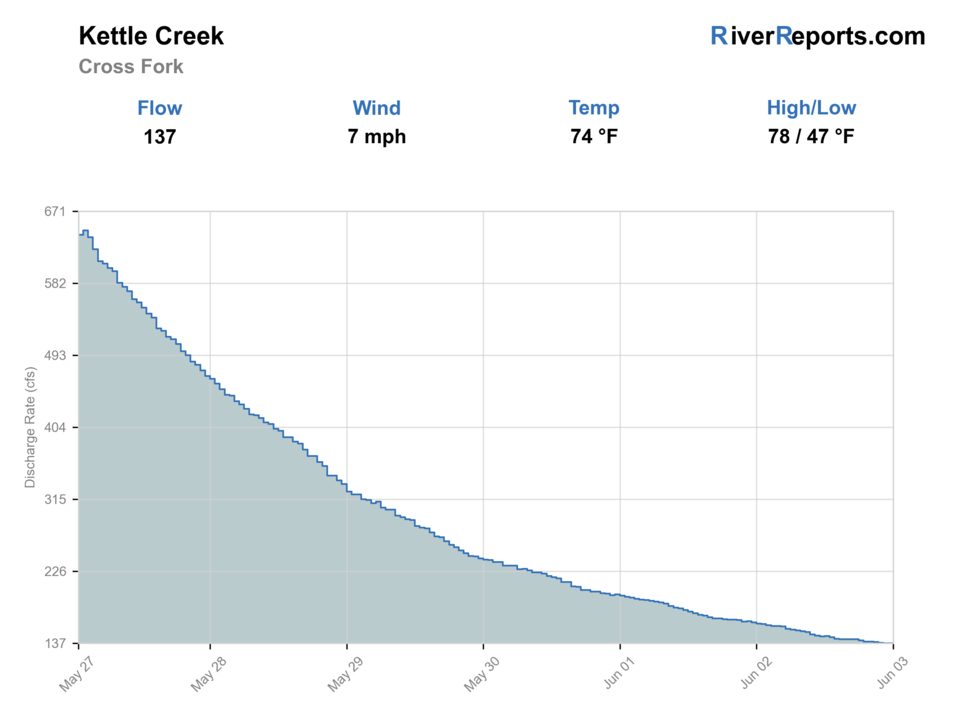
USGS data chart
Official USGS trend
Streamflow over the latest USGS reporting window.
Latest
137 cfs
Jun 3, 5 PM UTC
Weather
River weather report
Weather can change wading safety, road access, water temperature, hatches, and the best time of day to fish.
Live forecast loads as you reach this section
This keeps the report fast while still using the official National Weather Service forecast point.
Hatches and flies
Hatch chart and fly picks
March to April
Midges, little black stones, early BWOs, and early caddis
Zebra midge, black stonefly nymph, BWO emerger, pheasant tail, caddis pupa
Late April to May
Quill Gordons, Hendricksons, caddis, March Browns, and sulfurs where timing lines up
Parachute Adams, Hendrickson, March Brown, elk hair caddis, sulfur comparadun
June to July
Caddis, yellow sallies, slate drakes, small mayflies, and pocket-water attractor windows
Stimulator, X-caddis, yellow sally, parachute Adams, perdigon, hare's ear
August to September
Terrestrials, ants, beetles, hoppers, small caddis, and evening spinner falls
Foam ant, beetle, small hopper, CDC caddis, rusty spinner
October to winter
BWOs, midges, small streamers, and slow cold-water nymphing
BWO emerger, midge pupa, soft hackle, small olive bugger, jig nymph
Dry flies
Parachute Adams, BWO, Hendrickson, elk hair caddis, X-caddis, ant, beetle, small hopper
Use during visible rises, soft riffle edges, pocket-water prospecting, and summer terrestrial windows.
Nymphs
Pheasant tail, hare's ear, perdigon, caddis pupa, zebra midge, small black stonefly
Use in cold water, low light, deeper slots, or when the surface hatch is not strong enough to move fish.
Streamers
Olive bugger, black bugger, small sculpin, leech, soft-hackle streamer
Use along banks and deeper bends when flows have enough color for a moving fly but are still safe.
Soft hackles
Partridge and orange, partridge and green, pheasant tail soft hackle, caddis soft hackle
Swing or lift them through broken riffles when caddis, olives, or small mayflies are active.
Tactics
How to fish it
Start with the gauge and temperature, then choose the reach. Kettle Creek can change character between tributary water, state park water, and lower affected sections.
In clear water, stay low, fish upstream or quartering upstream, and make the first drift count before stepping into the run.
Use a dry-dropper through pocket water when fish are willing to look up; switch to a light nymph rig when bright sun pushes fish deeper.
After rain, fish softer edges and bank cover before wading. A small streamer can be better than forcing a dry fly through stained water.
Do not assume every pullout is public. Match maps, signs, DCNR/PFBC information, and posted property before entering.
Rigging
Rod, leader, and setup notes
A 3 to 5-weight rod covers most Kettle Creek trout work. Use the lighter rod on small tributaries and a 5-weight when wind, indicators, or streamers matter.
For dries, start with a 9-foot 4X or 5X leader and adjust down only when larger flies or stained water make it reasonable.
For dry-droppers, use a buoyant caddis, stimulator, or parachute dry with a small pheasant tail, hare's ear, or caddis pupa 18 to 30 inches below.
For nymphs, keep weight light enough to avoid constant bottom contact in shallow riffles, then add depth for bigger pools and cold water.
Access
Access and planning notes
Cross Fork gauge area
Primary flow and clarity checkWade / float / trail
RiverReports / USGS gauge / wade
When to pick it
Start here when flow, temperature, and storm response decide whether to fish.
Caution
The gauge does not confirm every nearby pullout, bank, or private edge.
Kettle Creek State Park
Public planning baseWade / float / trail
State park / wade / bank
When to pick it
Use this when DCNR rules, park access, cool water, and safe banks line up.
Caution
Day-use hours, road conditions, and lower-water quality notes still matter.
Upper watershed and tributaries
Cool-water backupWade / float / trail
Forest road / small-stream scout
When to pick it
Pick these when mainstem heat or pressure makes a smaller legal public reach more responsible.
Caution
Each tributary needs its own access, rule, and temperature check.
Download maps before leaving service; DCNR notes cell service can be unpredictable in many Pennsylvania state parks.
Use state park and state forest information for public access, but still respect signs, closures, and private land.
Treat tributary fishing as a separate rule and access check. Small streams can have special rules, fragile wild trout, and limited parking.
After storms, consider road safety and bank stability before deciding that the gauge alone makes the trip worthwhile.
Regulations
Check before fishing
A Pennsylvania fishing license and trout permit may be required when fishing for trout. PFBC trout rules, stocked-water dates, special-regulation sections, and DCNR park rules should be checked before fishing; this report does not replace current regulations.
Primary base
Cross Fork, Kettle Creek State Park, and Renovo-area services
Best day style
Walk-and-wade freestone trout scouting with a temperature check
Check first
RiverReports, USGS 01544500, NWS forecast, PFBC trout rules, DCNR access, and water temperature
Safety
Fast rises after rain, cold water, warm low-flow trout stress, posted land, rough roads, and weak cell service
Gear
Helpful gear for this water
Thermometer
The most important summer tool; let temperature decide whether trout fishing is responsible.
3 to 5-weight rod
Covers small dries, dry-droppers, light nymphing, and modest streamers.
Wading staff
Freestone rocks, stained water, and sudden depth changes can make simple crossings risky.
Offline map
Use it for state park, state forest, road, and private-land decisions when cell service drops.
Small streamer box
Useful when rain adds a little color but the creek is still safe.
Nearby water
Other water to research
Backup logic
High or stained water
Wait for the Cross Fork trend to settle or compare Pine Creek.
Heat
Carry a thermometer, fish early only if trout recovery is safe, or shift to colder legal water.
Access uncertainty
Use DCNR/PFBC-supported public areas instead of guessing at pullouts or posted land.
Lower reach quality issue
Move upstream, use a legal tributary plan, or choose Pine Creek rather than forcing impacted water.
Pine Creek
A larger nearby Pennsylvania trout plan with the same temperature-first summer caution.
First Fork Sinnemahoning Creek
A nearby RiverReports candidate worth researching for another north-central Pennsylvania trout plan.
Kettle Creek tributaries
Cold tributaries can be the better wild-trout plan, but each one needs its own access and regulation check.
FAQ
Fast answers
Is Kettle Creek fishable today?
Kettle Creek looks very fishable right now. The live score is 96/100, based on current flow, weather, public alerts, and the report's planning context. Recheck the linked gauge and forecast before leaving because conditions can change quickly after rain, heat, access changes, or flow swings.
What flow is best for Kettle Creek?
Use the Cross Fork gauge trend more than a single number: stable or slowly falling water is usually more useful than a sharp rise. Match the gauge to actual clarity and depth before wading.
When should I skip Kettle Creek?
Skip trout fishing during blown-out water, thunderstorm runoff, weak ice, posted-access uncertainty, or warm low-flow afternoons.
Is Kettle Creek safe to wade right now?
The fishability score is not a wading guarantee. Wade only where your chosen access has safe edges, clear footing, legal entry, and no forced crossings; high, rising, stained, or storm-affected water should be treated conservatively.
Is Kettle Creek good for fly fishing?
Yes, when flows are stable and water temperatures are trout-safe. It is most useful as a reach-by-reach freestone plan rather than one uniform creek report.
Which flow should I check for Kettle Creek?
Use the RiverReports Kettle Creek at Cross Fork chart for a quick visual read and USGS 01544500 as the official monitoring source.
What flies should I bring to Kettle Creek?
Bring caddis, BWOs, classic eastern mayflies, small stoneflies, pheasant tails, hare's ears, perdigons, ants, beetles, and small streamers.
Can I fish Kettle Creek State Park?
The park is a useful public planning base, but anglers still need the correct Pennsylvania license/permit, current PFBC rules, DCNR rules, and reach-specific access awareness.
Sources
Source set for this report
Reviewed 2026-06-01