
North Carolina / Southeast
Toe River
A Toe River report for anglers sorting out North Toe town water, South Toe public access, delayed-harvest rules, and mountain weather before the drive.
Image: Generated regional planning image for Toe River / BlueStreamFly generated; not exact location / BlueStreamFlyFishability now: Toe River fishability today
GreatData confidence: High96/100
Fishable now because the live gauge is falling, weather is mild, and no public alert is active.
Flow observed
4:30 PM UTC
Weather observed
5:00 PM UTC
Score calculated
5:24 PM UTC
Why this rating
Flow
Weather
Public alerts
Next 6-12 hours
Improving / hold
A falling gauge and usable weather should keep the next 6-12 hours in play unless tributaries stain or heat builds.
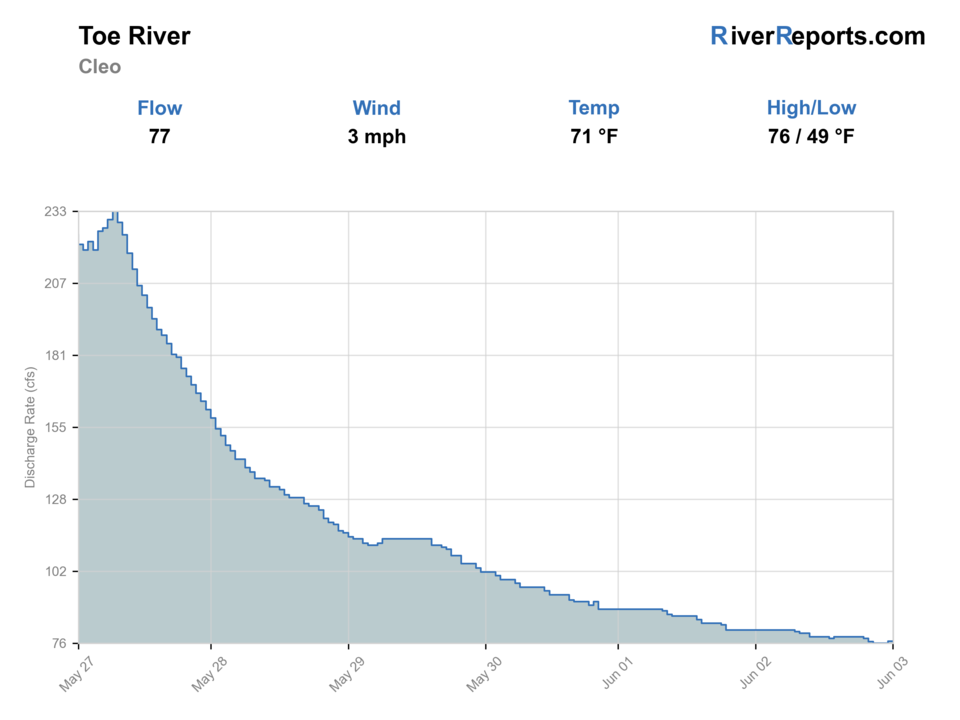
USGS flow
76 cfs
Current trend: flow falling, rating likely holding strong unless weather or clarity changes.
More planning details: flies, flow bands, and live source checks
Fish it today
Start here
Base from Spruce Pine or Burnsville, check the gauge, then choose between managed North Toe water and the quieter South Toe public corridor.
Best flow clue
Stable or gently falling clear flows that leave fishable pocket-water seams and safe wading along banks or bars.
Skip trigger
Skip when storms are building, flows are rising, South Toe access is uncertain, or you cannot verify the rule set for your target reach.
Flow decision bands
Stable clear South Toe flow
This is the best signal for short Blue Ridge wades, dry-droppers, and pocket-water nymphing.
Rising storm water
A jumping gauge, muddy tributaries, or thunderstorm risk should move the day off the river.
Low bright trout water
Fish shaded low-light windows with lighter tippet, fewer casts, and temperature checks.
Branch or rule mismatch
A fishable gauge does not confirm the North Toe, South Toe, delayed-harvest, or Mountain Heritage rule set for your exact spot.
USGS flow
76 cfs
Current trend: flow falling, rating likely holding strong unless weather or clarity changes.
Live USGS flow
76 cfs / falling about 14%
Live NWS forecast
71F / Sunny
Water temperature not verified
Heat guidance uses weather and river type unless an official water-temperature value is available.
No NWS alert flag
No active NWS alert was returned for this forecast point.
RiverReports is the quick chart, backed by USGS 03463300 South Toe River near Celo for official gauge context.
North Carolina trout rules vary by reach, and the Spruce Pine Mountain Heritage Trout Water section follows its own seasonal tackle and harvest rules.
Pisgah and ranger-district access in the South Toe corridor can change with weather, storm recovery, or campground status.
Clear water, slick cobble, and fast storm rises reward a smaller-water mindset even when the river looks broad enough to cover aggressively.
Editorial review
How this report is maintained
This report starts with official regulation, access, flow, weather, and public-land sources, then adds practical planning guidance for fly anglers.
Byline
BlueStreamFly editorial desk
Reviewed by
BlueStreamFly source review
Maintained by
BlueStreamFly
Last material review
2026-06-03
Report confidence
Good confidence
88/100
Good confidence: RiverReports, USGS 03463300 South Toe near Celo, NCWRC trout sources, Spruce Pine Mountain Heritage materials, Pisgah access pages, weather data, and route-specific Toe River guidance support the page. Confidence is moderated by branch-to-branch differences, storm recovery, campground status, and seasonal rule changes.
Regulations
NCWRC trout regulations, maps, and Mountain Heritage materials support branch-specific rule checks.
Access
Pisgah South Toe access sources and Spruce Pine materials support public planning, with campground, road, and posted access status still requiring current checks.
Flow and weather
RiverReports, USGS 03463300 near Celo, and the National Weather Service point support live flow and weather decisions.
Fishing usefulness
The page now separates South Toe flow, branch choice, town versus forest access, storm skips, warm-water restraint, and Blue Ridge backup choices.
Fishability dashboard and source review
2026-06-03 / material content or source review
RiverReports, USGS 03463300 South Toe River near Celo, NCWRC trout regulations and maps, Spruce Pine Mountain Heritage Trout Water materials, Pisgah South Toe access sources, National Weather Service point data, and route-specific Blue Ridge safety sources were checked before updating the current-fishability decision layer.
2026-06-03
Updated Toe River to the current fishability-page standard with South Toe flow bands, branch and access cards, storm and rule backup cues, stable fishability SEO, and confidence signals.
2026-05-26
Published a new Toe River report with branch-specific planning, source-checked North Carolina trout rule reminders, South Toe access context, and mountain-weather guidance.
Angler planning edge
Local details that change the plan
Best for
Blue Ridge trout wading, Dry-dropper and pocket-water days, Flexible branch-by-branch mountain trip planning
Wade or float
This is a wade-first report. The Toe rewards short careful sessions, not trying to power through every visible run.
Best flows
Stable or gently falling clear flows that leave fishable pocket-water seams and safe wading along banks or bars.
When to skip
Skip when storms are building, flows are rising, South Toe access is uncertain, or you cannot verify the rule set for your target reach.
Local plan
Base from Spruce Pine or Burnsville, check the gauge, then choose between managed North Toe water and the quieter South Toe public corridor.
Pressure
Easy town access can pull anglers into the same obvious North Toe water. Walking a little or shifting branches often improves the day.
Access nuance
The basin gets tricky when weather damages roads or campgrounds. A fishable gauge does not guarantee your chosen South Toe access is open.
Backup water
Watauga River, Linville River, and Oconaluftee River are safer pivots than forcing the wrong Toe branch on the wrong day.
About the river
Setting, character, and why it fishes the way it does.
The Toe is best understood as a basin page, not a single uniform trout run. The North Toe around Spruce Pine carries town-water and seasonal management context, while the South Toe corridor adds public forest access, campground pressure, and a more classic Blue Ridge freestone feel.
That split is what makes the river useful. If one branch is crowded, blown out, or under the wrong seasonal rule set for your day, the other may still be worth a look.
The tradeoff is that you have to plan better than the average roadside stop. Delayed-harvest timing, Mountain Heritage Trout Water dates, and ranger-district access status all matter here.
Target species
Rainbow trout
A common target in managed Toe-basin trout water when flows and seasonal rules line up.
Brown trout
Worth targeting in deeper bends, lower light, and bigger pocket-water seams.
Brook trout
Native-trout context is strongest in colder tributary or upper-water situations; handle fish carefully.
Reading the water
Stable clear flow
Best for dry-dropper fishing, short nymph drifts, and careful seam-by-seam coverage.
Rising storm water
Leave the river. Blue Ridge freestones can change fast.
Low bright water
Use longer leaders, lighter tippet, and shaded-bank approaches.
Light stain
Small streamers or slightly larger nymphs can work well in protected current edges.
Best seasons
Spring
Good hatches and active trout when storms are not spiking flows.
Summer
Fish early and let temperature, storms, and recreation pressure shape the day.
Fall
Often the easiest mix of cooler water, better wading, and clear basin choices.
Winter
A technical but reasonable plan in the right weather and rule window.
Preferred flow source
Toe River near Celo
RiverReports is the preferred chart source when coverage exists. When a matching USGS gauge exists, keep it open as the official backstop for station data and current hydrograph context.
USGS data chart
Official USGS trend
Streamflow over the latest USGS reporting window.
Latest
76 cfs
Jun 3, 4 PM UTC
Weather
River weather report
Weather can change wading safety, road access, water temperature, hatches, and the best time of day to fish.
Live forecast loads as you reach this section
This keeps the report fast while still using the official National Weather Service forecast point.
Hatches and flies
Hatch chart and fly picks
March-April
Quill-style mayflies, midges, and early caddis
Parachute Adams, pheasant tail, zebra midge, caddis pupa
April-June
Caddis, yellow sallies, and sulphur-style mayflies
Elk hair caddis, yellow stimulator, hare's ear, soft hackle
June-August
Terrestrials, caddis, and small mayflies
Ant, beetle, foam dry-dropper, X-caddis
September-November
BWOs, midges, and caddis
BWO emerger, zebra midge, olive bugger
Blue Ridge dries
Parachute Adams, elk hair caddis, yellow stimulator, ant
Broken current and shaded banks let fish look up without long drifts.
Pocket-water nymphs
Pheasant tail, hare's ear, caddis pupa, perdigon
Fish stay down in clear current or when cooler morning water slows surface activity.
Small streamers
Olive bugger, black bugger, small sculpin
Low light, light stain, or deeper banks make a bigger profile worthwhile.
Tactics
How to fish it
Choose the branch first: North Toe for easier managed access, South Toe for forest-corridor scouting and public pull-ins.
Fish short drifts through pocket water and soft seams before stepping into the run.
Use lighter tippet and cleaner first casts when the river is low and bright.
Let weather and rule changes make the go or no-go decision early instead of after a long mountain drive.
Rigging
Rod, leader, and setup notes
A 4- or 5-weight rod covers most Toe trout plans.
Carry 4X through 6X for dries and nymphs, with 3X for small streamers or heavier dropper rigs.
Dry-dropper rigs are efficient in summer pocket water, while small indicators help in deeper spring slots.
Pack a wading staff and rain shell because slick cobble and fast storm shifts are standard Blue Ridge problems.
Access
Access and planning notes
Spruce Pine Mountain Heritage corridor
Town-water rule checkWade / float / trail
Mapped town water / wade
When to pick it
Use it when current seasonal rules and clear water support a simple legal session.
Caution
Town-water rules and timing can differ from nearby trout water.
Black Mountain Campground and South Toe Road
Forest-corridor startWade / float / trail
Campground / road scout / wade
When to pick it
Start here when Pisgah access, weather, and flow are all straightforward.
Caution
Storm recovery or campground status can override a good gauge.
Carolina Hemlocks Recreation Area
South Toe public accessWade / float / trail
Recreation area / wade / short walks
When to pick it
Pick it when the recreation area is open and water is cool and clear enough for trout handling.
Caution
Recreation pressure, slick cobble, and storm rises narrow the safe window.
The Toe is not one uniform rule zone. Match your branch and pullout to the current NC trout map or posted site guidance.
South Toe access depends on ranger-district conditions as much as river level.
After major storms, do not assume repaired roads, campgrounds, or pull-ins are open just because the gauge looks fishable.
Regulations
Check before fishing
Confirm current NCWRC trout rules, including Mountain Heritage Trout Water or delayed-harvest details where applicable to your chosen Toe reach.
Primary base
Spruce Pine, Burnsville, Little Switzerland, or the broader Blue Ridge high country
Best day style
Roadside town water plus forest-corridor public access with rule changes by reach
Check first
RiverReports, USGS 03463300, NC trout regulations and maps, South Toe access status, and the NWS mountain forecast
Safety
Fast storm rises, slick cobble, road or campground closures, and mixing up branch-specific trout rules
Gear
Helpful gear for this water
4- or 5-weight rod
A good fit for dries, nymphs, and small streamers in Blue Ridge trout water.
Long leaders
Helpful in clear water and on pressured town-water stretches.
Wading staff
Useful on slick ledge rock and rounded mountain cobble.
Rain shell
Thunderstorms and cool ridge weather shifts can change the day fast.
Nearby water
Other water to research
Backup logic
Storm rise or stain
Compare the Watauga, Linville, or Oconaluftee only after checking each route's current flow and access.
Warm trout water
Fish a cool short window or stop trout fishing rather than extending handling pressure.
Forest access issue
Switch branches or use confirmed town access instead of assuming a campground or pull-in is open.
Rule uncertainty
Use NCWRC trout maps and posted signs before choosing tackle or harvest expectations.
Watauga River
A stronger backup when you want a better-known North Carolina trout program.
Linville River
A nearby freestone option with its own public-land planning demands.
Oconaluftee River
A Smokies-adjacent backup when you want different access and trout-management context.
FAQ
Fast answers
Is Toe River fishable today?
Toe River looks very fishable right now. The live score is 96/100, based on current flow, weather, public alerts, and the report's planning context. Recheck the linked gauge and forecast before leaving because conditions can change quickly after rain, heat, access changes, or flow swings.
What flow is best for Toe River?
Stable or gently falling clear flows that leave fishable pocket-water seams and safe wading along banks or bars.
When should I skip Toe River?
Skip when storms are building, flows are rising, South Toe access is uncertain, or you cannot verify the rule set for your target reach.
Is Toe River safe to wade right now?
The fishability score is not a wading guarantee. Wade only where your chosen access has safe edges, clear footing, legal entry, and no forced crossings; high, rising, stained, or storm-affected water should be treated conservatively.
What gauge should I check for the Toe River?
Use RiverReports for the quick chart and USGS 03463300 South Toe River near Celo for the official gauge reference.
Is the Toe River mostly a wade fishery?
Yes. Most fly anglers plan short wading sessions from town pull-ins or forest-road access points rather than a float trip.
What is the main mistake on the Toe?
Mixing up the branch, the access corridor, or the seasonal trout rules. Confirm all three before you fish.
Sources
Source set for this report
Reviewed 2026-06-03