
Montana / West
Smith River
A Smith River planning report for anglers who need more than a flow number: permit rules, multi-day logistics, trout tactics, and when the float is not worth forcing.
Image: Generated regional planning image for Smith River / BlueStreamFly generated; not exact location / BlueStreamFlyFishability now: Smith River fishability today
GreatData confidence: High96/100
Fishable now because the live gauge is stable, weather is mild, and no public alert is active.
Flow observed
4:45 PM UTC
Weather observed
5:00 PM UTC
Score calculated
5:24 PM UTC
Why this rating
Flow
Weather
Public alerts
Next 6-12 hours
Hold
Stable live data supports staying with the plan, but recheck the gauge and forecast before leaving.
USGS flow
914 cfs
Current trend: flow stable, so weather, temperature, and access checks drive the next change.
More planning details: flies, flow bands, and live source checks
Fish it today
Start here
Start with the Eden gauge, permit details, launch date, and camp plan. If those pieces still work, build the fishing day around a few clean banks and shelves instead of assuming every mile of the corridor will fish well.
Best flow clue
Use RiverReports and USGS 06077500 near Eden together. The best window is a flow that keeps boats moving while still letting you fish shelves, banks, and canyon structure; high push, low drag, or ugly weather should change the whole plan.
Skip trigger
Skip or pivot when high water makes the canyon unsafe, low water turns the trip into a drag, permits or launch logistics are not solid, or weather and smoke turn a multi-day float into a bad risk.
Flow decision bands
Low but still possible
Low Smith flow can still fish, but drag risk, slower boat travel, and exposed riffles should make you reassess whether the permit trip is still worth the effort.
Best permit-float window
Steady Eden flow that still moves boats cleanly while leaving fishable banks and canyon structure is the cleanest signal for a worthwhile Smith launch.
Pushy or unsafe
High cold water, fast banks, or weather that turns the canyon into a safety problem should cancel the launch instead of just changing fly choice.
Logistics and weather caution
A fishable graph does not override permit details, camp obligations, wind, smoke, food and waste planning, or a takeout that no longer feels cleanly manageable.
USGS flow
914 cfs
Current trend: flow stable, so weather, temperature, and access checks drive the next change.
Live USGS flow
908 cfs / stable
Live NWS forecast
62F / Mostly Sunny
Water temperature not verified
Heat guidance uses weather and river type unless an official water-temperature value is available.
No NWS alert flag
No active NWS alert was returned for this forecast point.
Montana FWP says permits and fees are required to float the 59-mile Camp Baker to Eden Bridge corridor.
RiverReports provides the quick chart, with USGS 06077500 near Eden used as the official gauge reference for this page.
FWP notes that the typical float season often runs from mid-April through mid-July, but actual conditions vary with snowpack, rain, irrigation, and fall opportunities.
The Smith needs food storage, waste, boat-inspection, camp, shuttle, and weather planning before it needs a perfect fly list.
Editorial review
How this report is maintained
This Smith River report is maintained from RiverReports and USGS Eden flow data, Montana FWP Smith River corridor and permit-holder information, restricted-use river permit guidance, fishing-access information, weather, generated-image disclosure, and permit-managed float trout planning sources.
Byline
BlueStreamFly editorial team
Reviewed by
BlueStreamFly source review
Maintained by
Mountain Brook Run LLC
Last material review
2026-05-31
Report confidence
High confidence
90/100
High confidence: RiverReports, USGS Eden flow, Montana FWP Smith corridor and permit-holder information, restricted-use permit guidance, fishing-access sources, weather, and generated-image disclosure are present. Confidence is moderated by permit timing, multi-day logistics, spring weather, low-water drag risk, and canyon safety.
Regulations
Montana FWP Smith River and restricted-use permit guidance are linked for current corridor and launch checks.
Flow support
RiverReports Smith River near Eden is backed by USGS 06077500.
Access support
FWP Smith corridor, permit-holder, and fishing-access sources provide concrete launch and takeout planning anchors.
Weather and safety
The National Weather Service point resolved and the page calls out canyon weather, high-water safety, low-water drag risk, and multi-day float logistics.
Angler usefulness
The page separates permit logistics, launch timing, floatability, weather, and backup-river decisions.
Editorial review
A public correction path, source standards page, generated-image disclosure, and public review history are included.
Fishability source review
2026-05-31 / material content or source review
RiverReports Eden flow support, USGS 06077500, Montana FWP Smith River corridor and permit-holder information, restricted-use river permit guidance, fishing-access information, the National Weather Service point, and image disclosure were rechecked before adding the Pine Creek-standard current-fishability layer.
2026-05-31
Upgraded the page to the Pine Creek fishability standard with reviewed route profile, permit-float decision bands, access cards, backup logic, and a top-page current-fishability answer.
2026-05-26
Initial source-reviewed report published with Smith River permit, flow, access, tactics, regulations, and FAQs.
Angler planning edge
Local details that change the plan
Best for
Permit-based multi-day float anglers who need the Smith to be both fishable and logistically realistic before launching, Trips where the Eden gauge, permit timing, camp schedule, weather, and low-impact corridor rules all matter as much as the trout fishing, Spring and early-season canyon trout plans when flow still moves boats cleanly without turning the corridor unsafe, Anglers deciding whether to keep a Smith launch or pivot to an open-access Montana river when flow or logistics fall apart
Wade or float
Treat the Smith as a permit-managed float river first and a trout trip second. The access issue is not finding the river; it is making sure the launch, camps, weather, and takeout all still fit a safe corridor trip.
Best flows
Use RiverReports and USGS 06077500 near Eden together. The best window is a flow that keeps boats moving while still letting you fish shelves, banks, and canyon structure; high push, low drag, or ugly weather should change the whole plan.
When to skip
Skip or pivot when high water makes the canyon unsafe, low water turns the trip into a drag, permits or launch logistics are not solid, or weather and smoke turn a multi-day float into a bad risk.
Local plan
Start with the Eden gauge, permit details, launch date, and camp plan. If those pieces still work, build the fishing day around a few clean banks and shelves instead of assuming every mile of the corridor will fish well.
Pressure
Permit limits protect the corridor better than open-access rivers, but launch timing, camp spacing, and the number of multi-day boats on the water still shape the experience.
Access nuance
FWP's Smith corridor and permit-holder guidance are the public framework. Follow launch, camp, inspection, and takeout rules exactly instead of improvising access or camps once you are committed to the canyon.
Backup water
If Smith flow or permit logistics fall apart, move to an open-access Montana trout river instead of forcing a low-water drag or high-water canyon launch.
About the river
Setting, character, and why it fishes the way it does.
The Smith River is a remote central Montana canyon float with one main public put-in at Camp Baker and one take-out at Eden Bridge for the managed corridor.
Its appeal is the combination of limestone canyon scenery, multi-day rhythm, and trout fishing, but that same remoteness makes planning mistakes bigger than on a roadside river.
This page is written for anglers deciding whether a permitted launch window still looks fishable, what to check before packing, and how to fish responsibly once the trip begins.
Target species
Brown trout
A key target around undercut banks, canyon shelves, and low-light streamer water.
Rainbow trout
Common enough to shape nymphing and dry-dropper plans through good holding water.
Mountain whitefish
Often part of the catch when nymphing deeper runs and softer seams.
Reading the water
Good float flow
The sweet spot keeps boats moving, leaves room for safe camp landings, and still gives trout defined bank structure.
Low water
Expect more dragging, slower travel, warmer afternoons, and a need to fish early and carefully.
High cold water
Prioritize boat safety and fish inside seams, protected banks, and slower canyon edges.
Warm summer water
Shorten fishing windows and stop when trout handling would be stressful.
Best seasons
Mid-April to June
Often the core permit-and-fishing window if runoff and storms stay manageable.
Early July
Can still fish well in some years, but low or warm water becomes a larger risk.
September and October
Occasional fall opportunities exist when flows and weather cooperate.
Winter
Not a practical fly-fishing target for most users because access, weather, and float logistics dominate.
Preferred flow source
Smith River near Eden
RiverReports is the preferred chart source when coverage exists. When a matching USGS gauge exists, keep it open as the official backstop for station data and current hydrograph context.
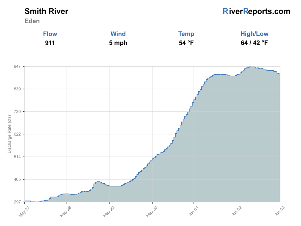
USGS data chart
Official USGS trend
Streamflow over the latest USGS reporting window.
Latest
914 cfs
Jun 3, 3 PM UTC
Weather
River weather report
Weather can change wading safety, road access, water temperature, hatches, and the best time of day to fish.
Live forecast loads as you reach this section
This keeps the report fast while still using the official National Weather Service forecast point.
Hatches and flies
Hatch chart and fly picks
Spring
Midges, BWOs, skwalas, early caddis
Zebra midge, BWO emerger, skwala dry, caddis pupa
Early summer
Caddis, PMDs, golden stones
Elk hair caddis, PMD cripple, pat's rubber legs
Summer
Caddis, terrestrials, attractors
Foam hopper, ant, chubby, beadhead dropper
Fall
BWOs, midges, streamer windows
BWO emerger, zebra midge, olive bugger
Boat nymphs
Pat's rubber legs, pheasant tail, caddis pupa, perdigon
You need steady production through deeper banks and canyon seams.
Smith dries
Skwala dry, elk hair caddis, PMD cripple, hopper
The river is clear enough and fish are willing to rise along banks.
Canyon streamers
Olive bugger, black leech, tan sculpin
Cloud cover, off-color water, or low light makes larger fish more willing.
Tactics
How to fish it
Build the fishing plan around the daily float mileage and camp schedule; do not let one good bank make you miss a campsite window.
Fish from the boat where safe, then stop only at durable legal bars and camps where footing and land ownership are clear.
Use dry-dropper rigs for banks and soft seams, then switch to nymphs or streamers when weather turns cold or water stains.
Treat every trout carefully. Remote trips tempt anglers to overfish long days, but warm afternoons and low water should shorten the session.
Rigging
Rod, leader, and setup notes
A 5- or 6-weight rod is the safest all-around Smith choice for nymphs, dries, and light streamers from a boat.
Carry backup leaders and tippet because multi-day canyon trips punish small missing items.
Pack a thermometer, rain shell, dry bags, repair kit, and enough flies to handle both cold spring weather and clear low water.
Use barbless or pinched-barb flies for faster releases during long float days.
Access
Access and planning notes
Eden gauge check
Primary launch decisionWade / float / trail
Gauge / float
When to pick it
Start here when the river has to be both fishable and floatable before you commit to the whole permit trip.
Caution
The gauge does not settle weather, camp logistics, shuttle timing, or the practical feel of the canyon on your launch dates.
Camp Baker permit launch
Launch and logistics checkpointWade / float / trail
Permit access / float launch
When to pick it
Use it when you need to confirm the launch itself still fits the flow, gear, and schedule before thinking about the first trout bank.
Caution
A valid permit does not make a bad flow, rough weather, or weak shuttle plan acceptable.
Eden Bridge takeout plan
Trip finish and safety checkWade / float / trail
Takeout / shuttle / float logistics
When to pick it
Pick it when you want the takeout and multi-day timing settled before committing to a canyon launch.
Caution
Do not treat the takeout as an afterthought if flow, weather, or camp timing are already straining the trip.
A Smith River trip is not a casual day float. FWP requires permits and fees for the managed corridor, and floaters need to follow registration and camp procedures.
FWP highlights food storage, human-waste, aquatic-invasive-species, and travel-in-bear-country requirements for permit holders.
Private-land boundaries, limited exits, and remote weather mean the safest plan is conservative even when the fishing looks good.
Regulations
Check before fishing
Check Montana fishing regulations plus the current Smith River permit-holder rules before packing. A valid fishing license is separate from Smith River float authorization.
Primary base
White Sulphur Springs, Camp Baker, or Great Falls
Best day style
Permit-based multi-day float with limited public put-in and take-out options
Check first
RiverReports, USGS 06077500, FWP Smith River permit instructions, weather, camp schedule, and current restrictions
Safety
Remote canyon travel, limited exits, cold spring storms, low-water dragging, food storage, waste rules, and boat inspection requirements
Gear
Helpful gear for this water
5- or 6-weight rod
Covers the full mix of boat nymphing, dry-dropper fishing, and streamer work.
Thermometer
Important in low or warm water when trout handling decisions matter.
Dry bags and rain gear
Required practical gear for changing canyon weather and multi-day packing.
Permit paperwork and river kit
Keep float authorization, camp plan, waste system, and boat inspection requirements organized.
Nearby water
Other water to research
Backup logic
High water
Cancel the Smith launch when high water makes canyon travel unsafe and move to an open-access river instead of trying to tough it out.
Low water or drag risk
Be honest about whether shallow riffles and long drag sections turn the permit trip into work instead of fishing, then pivot before launching.
Smoke or weather
Treat smoke, cold storm systems, or hard wind as full fishability and safety limiters for a multi-day canyon float.
Permit or access issue
Use only confirmed Smith permit and corridor rules and pivot immediately if launch, camp, inspection, or shuttle details are not fully resolved.
Missouri River
A more reliable tailwater backup if Smith River permit timing or flows do not cooperate.
Dearborn River
A smaller freestone comparison in the same broad region when access and flows line up.
Jefferson River
A larger valley-river option with less permit complexity but stronger warm-water constraints.
FAQ
Fast answers
Is Smith River fishable today?
Smith River looks very fishable right now. The live score is 96/100, based on current flow, weather, public alerts, and the report's planning context. Recheck the linked gauge and forecast before leaving because conditions can change quickly after rain, heat, access changes, or flow swings.
What flow is best for Smith River?
Use RiverReports and USGS 06077500 near Eden together. The best window is a flow that keeps boats moving while still letting you fish shelves, banks, and canyon structure; high push, low drag, or ugly weather should change the whole plan.
When should I skip Smith River?
Skip or pivot when high water makes the canyon unsafe, low water turns the trip into a drag, permits or launch logistics are not solid, or weather and smoke turn a multi-day float into a bad risk.
Is Smith River safe to wade right now?
The fishability score is not a wading guarantee. Wade only where your chosen access has safe edges, clear footing, legal entry, and no forced crossings; high, rising, stained, or storm-affected water should be treated conservatively.
Do you need a permit to float the Smith River in Montana?
Yes. Montana FWP says permits and fees are required to float the 59-mile Camp Baker to Eden Bridge corridor.
When is the best time to fish the Smith River?
The typical float season often centers on mid-April through mid-July, but the best fishing depends on snowpack, rain, irrigation, water temperature, and your permit date.
Can you fish the Smith River as a simple day trip?
Not in the managed corridor. Most Smith River fishing is tied to the permitted multi-day float structure, so logistics come first.
Sources
Source set for this report
Reviewed 2026-05-31