Montana / West
Middle Fork Flathead River
A Middle Fork Flathead report for anglers checking West Glacier flow, Glacier and USFS access rules, native cutthroat tactics, and weather.
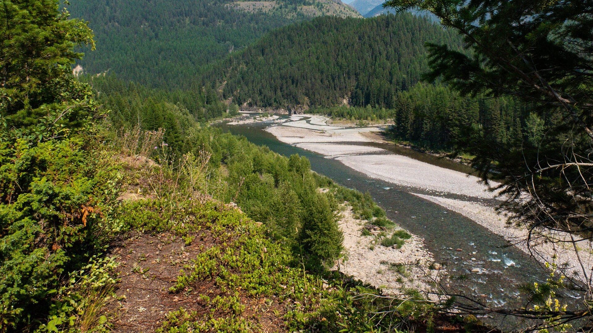
Image: Middle Fork Flathead River near Izaak Walton Inn Montana / CC BY-SA 4.0 / Burley PackwoodFishability now: Middle Fork Flathead River fishability today
GreatData confidence: High96/100
Fishable now because the live gauge is falling, weather is mild, and no public alert is active.
Flow observed
3:45 PM UTC
Weather observed
4:00 PM UTC
Score calculated
4:20 PM UTC
Why this rating
Flow
Water temperature
Public alerts
Next 6-12 hours
Improving / hold
A falling gauge and usable weather should keep the next 6-12 hours in play unless tributaries stain or heat builds.
USGS flow
13,800 cfs
Current trend: flow falling, rating likely holding strong unless weather or clarity changes.
More planning details: flies, flow bands, and live source checks
Fish it today
Start here
Start with the West Glacier flow and decide whether the day is a short roadside wade, a Paola-area access plan, or a boat/camp plan. Then keep flies simple and prioritize soft edges over hero wading.
Best flow clue
Use RiverReports and USGS 12358500 near West Glacier together. Dropping green water after runoff is the practical window; high cold runoff or storm jumps should move the plan to safe banks or another river.
Skip trigger
Skip or pivot when runoff is high, roads or river camping rules do not fit the plan, park and state boundary details are unclear, bear-country travel is not prepared, or native-trout handling would be poor.
Flow decision bands
Cold but fishable
Cold clear Middle Fork water can still fish, but native-trout care and glacial current mean the best day usually happens on soft edges, not hero wades.
Best dropping green-water window
Dropping West Glacier flow with green clear water is the cleanest signal for attractor dries, caddis, dry-dropper fishing, and careful boat or bank plans.
Pushy or unsafe
High cold runoff, storm jumps, or any plan that depends on deep crossings or uncertain camp-to-boat logistics should move the day to safer water.
Park boundary and native-trout caution
A useful graph does not override park rules, river-camping logistics, bear-country travel, or cutthroat and bull-trout handling concerns.
USGS flow
13,800 cfs
Current trend: flow falling, rating likely holding strong unless weather or clarity changes.
Live USGS flow
13,800 cfs / falling about 11%
Live NWS forecast
58F / Sunny
Live water temperature
46F from USGS
No NWS alert flag
No active NWS alert was returned for this forecast point.
Use the West Glacier gauge for lower Middle Fork trend and wading safety.
Single-point hook and cutthroat handling rules matter; check FWP and NPS guidance.
Glacier boundary and licensing rules can differ depending on where you stand.
Runoff, cold water, and bear-country travel make safety part of the fishing plan.
Editorial review
How this report is maintained
This Middle Fork Flathead River report is maintained from RiverReports and USGS West Glacier flow data, Montana FWP fishing regulations, current closure and restriction sources, Glacier National Park fishing and river-camping information, Flathead National Forest access information, weather, media-credit, and native-trout freestone planning guidance.
Byline
BlueStreamFly editorial team
Reviewed by
BlueStreamFly source review
Maintained by
Mountain Brook Run LLC
Last material review
2026-05-31
Report confidence
High confidence
91/100
High confidence: RiverReports, USGS West Glacier flow, Montana FWP regulations, current restrictions, Glacier National Park guidance, Flathead National Forest access information, weather, and image credit are present. Confidence is moderated by park-boundary details, runoff, river-camping rules, remote travel, and native-trout protections.
Regulations
Montana FWP regulations, current restrictions, and Glacier fishing guidance are linked.
Flow support
RiverReports Middle Fork Flathead near West Glacier is backed by USGS 12358500.
Access support
Glacier and Flathead National Forest sources provide concrete access and river-camping planning anchors.
Weather and safety
The National Weather Service point resolved and the page calls out cold runoff, fast current, bears, park boundaries, and remote access.
Angler usefulness
The page separates runoff timing, native-trout care, park versus forest access, wade/boat choice, and backup-water decisions.
Editorial review
A public correction path, source standards page, image credit, and public review history are included.
Fishability source review
2026-05-31 / material content or source review
RiverReports West Glacier flow support, USGS 12358500, Montana FWP fishing regulations, current restriction pages, Glacier National Park fishing and river-camping pages, Flathead National Forest Paola River Access information, the National Weather Service point, and image credit were rechecked before adding the Pine Creek-standard current-fishability layer.
2026-05-31
Upgraded the page to the Pine Creek fishability standard with Glacier-edge decision bands, access cards, backup logic, and a reviewed route profile.
2026-05-28
Added Glacier-edge trip fit, wade-versus-float framing, runoff and native-trout skip cues, park and Forest Service access nuance, backup-water suggestions, editorial review signals, and a page-specific report-confidence meter after source review.
2026-05-25
Initial source-reviewed report published with flows, weather, hatches, flies, tactics, access, regulations, and FAQs.
Angler planning edge
Local details that change the plan
Best for
Glacier-area anglers planning a cold freestone day around West Glacier, Bear Creek, Paola, and the Hwy 2 corridor, Trips where West Glacier flow, park boundary rules, river-camping details, cold runoff, and native-trout handling all matter, Attractor dry, dry-dropper, caddis, stonefly, and terrestrial windows after runoff starts dropping, Anglers comparing Middle Fork Flathead water with the North Fork, Kootenai, or Bitterroot before choosing a valley
Wade or float
Treat the Middle Fork Flathead as a cold, powerful freestone with both wade and boat possibilities. The correct choice depends on the West Glacier flow, Glacier boundary details, river-camping rules, and your ability to stay out of fast glacial current.
Best flows
Use RiverReports and USGS 12358500 near West Glacier together. Dropping green water after runoff is the practical window; high cold runoff or storm jumps should move the plan to safe banks or another river.
When to skip
Skip or pivot when runoff is high, roads or river camping rules do not fit the plan, park and state boundary details are unclear, bear-country travel is not prepared, or native-trout handling would be poor.
Local plan
Start with the West Glacier flow and decide whether the day is a short roadside wade, a Paola-area access plan, or a boat/camp plan. Then keep flies simple and prioritize soft edges over hero wading.
Pressure
Pressure follows Glacier travel, summer clarity, and easy Hwy 2 access. Early starts and a conservative access plan help more than racing between pullouts.
Access nuance
Glacier National Park, Flathead National Forest, and Montana rules can all matter. Check whether you are fishing from park land, national forest access, bridges, or river-camping areas before assuming one rule set covers the day.
Backup water
If the Middle Fork is too high, cold, smoky, or logistically complicated, compare the North Fork Flathead for a more remote native-trout plan, the Kootenai for a larger below-dam option, or the Bitterroot for easier valley access.
About the river
Setting, character, and why it fishes the way it does.
The Middle Fork Flathead flows along the southern edge of Glacier National Park and the Hwy 2 corridor before joining the Flathead system near West Glacier.
The river's identity is cold, clear, and glacial. It has gravel bars, long runs, braided edges, powerful current, and native-trout considerations that require careful handling.
A useful report must clarify access boundaries. Fishing from park lands, bridges, USFS sites, and river camps can involve different rules or planning steps.
Target species
Westslope cutthroat trout
The main native trout focus; release carefully and follow current catch-and-release rules.
Rainbow trout
Present in some reaches; check current reach rules and identification carefully.
Mountain whitefish
Common in freestone runs and a useful nymphing indicator.
Bull trout
Protected. Do not target or retain bull trout, and release any incidental fish immediately.
Reading the water
Runoff high
Cold, fast, and unsafe for most wading. Wait for dropping flows and better clarity.
Dropping green
Fish big attractor dries, stonefly nymphs, and soft edges.
Clear summer flow
Use caddis, small attractors, ants, beetles, and light droppers.
Fall low water
Use stealth, smaller flies, and warmer afternoon windows.
Best seasons
Spring
Often high or cold; fish only safe windows and check access.
Early summer
Runoff drop opens the best attractor and stonefly opportunities.
Late summer
Caddis, terrestrials, and cutthroat dry-fly fishing are practical with temperature checks.
Fall
BWOs, small attractors, and streamers can work during stable weather.
Preferred flow source
Middle Fork Flathead near West Glacier
RiverReports is the preferred chart source when coverage exists. When a matching USGS gauge exists, keep it open as the official backstop for station data and current hydrograph context.
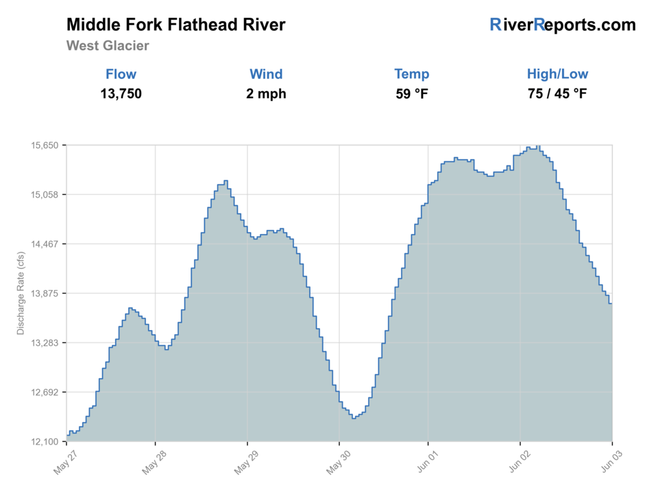
USGS data chart
Official USGS trend
Streamflow over the latest USGS reporting window.
Latest
13,800 cfs
Jun 3, 3 PM UTC
Weather
River weather report
Weather can change wading safety, road access, water temperature, hatches, and the best time of day to fish.
Live forecast loads as you reach this section
This keeps the report fast while still using the official National Weather Service forecast point.
Hatches and flies
Hatch chart and fly picks
Spring
Midges, BWOs, early stones, and cold-water nymphs
BWO emerger, zebra midge, rubberleg, pheasant tail
Late June to July
Runoff drop, caddis, PMDs, golden stones, and salmonfly leftovers
Chubby Chernobyl, caddis, PMD, Pat's rubber legs, small streamer
August
Hoppers, ants, beetles, spruce moths where present, evening caddis
Foam hopper, ant, beetle, caddis, small attractor dry
September to October
BWOs, October caddis, small baitfish, and cooling-water cutthroat windows
BWO, October caddis, soft hackle, small sculpin, leech
Stoneflies
Pat's rubber legs, Chubby Chernobyl, skwala, golden stone
Use before, during, and after stonefly movement or when trout sit tight to banks.
Mayflies and caddis
BWO, March Brown, PMD, caddis pupa, X-caddis
Use during spring and fall hatches or summer evening riffle feeding.
Terrestrials
Hoppers, ants, beetles, hopper-dropper rigs
Use during summer near grass, shade, undercuts, and slower bank seams.
Streamers
Sculpin, leech, sparkle minnow, small articulated streamer
Use in stained water, cloud cover, fall, or when larger trout hunt edges.
Tactics
How to fish it
Fish soft side channels, drop-offs, gravel edges, and boulder cushions after flows drop.
Use buoyant attractor dries with a small dropper when trout are opportunistic.
Keep fish wet and handle cutthroat quickly; identification matters in this drainage.
Avoid wading far from the bank in fast glacial current.
Plan access with Glacier, USFS, and river-camping rules before launching or camping.
Rigging
Rod, leader, and setup notes
A 5-weight is right for dry flies and small droppers; a 6-weight helps with wind and big water.
Use 4X to 5X for most dries and droppers, heavier for streamers.
Carry a wading staff, PFD for boats, and layers for cold water and mountain weather.
Bring bear-aware travel gear for Glacier-area access.
Keep rigs simple so you can move safely through braided water.
Access
Access and planning notes
West Glacier gauge check
Primary runoff decisionWade / float / trail
Gauge / wade edge / boat
When to pick it
Start here when the runoff trend decides whether the Middle Fork is ready for a real day or just a quick look from safe banks.
Caution
The gauge does not resolve park boundaries, river camping, or exact access farther up and down Hwy 2.
Paola and Hwy 2 corridor
Public access backboneWade / float / trail
Road corridor / short wade / boat scout
When to pick it
Use it when clear public access and fast scouting matter more than pushing deeper into remote logistics.
Caution
Fast current, railroad or highway edges, and crowding can still make a fishable river a poor fit.
Park edge and river-camping plan
Longer day or float setupWade / float / trail
Boundary check / camp / boat
When to pick it
Pick this when the day depends on Glacier-side rules, camping details, and a clearly defined drift instead of a casual roadside stop.
Caution
Do not assume one rule set covers park land, national forest access, and Montana river use all at once.
Glacier National Park, Montana FWP, and USFS rules can all matter depending on where you fish from.
River camping and boating plans require official rule checks, not just a map pin.
Cold runoff can make clear-looking water dangerous. Use the gauge and conservative wading.
Regulations
Check before fishing
Montana FWP and Glacier National Park guidance include Flathead-specific rules such as single-point hook and native-trout protections. Check current sources before fishing.
Primary base
West Glacier, Essex, Hungry Horse, or Columbia Falls
Best day style
Roadside river access, Glacier boundary planning, boats, gravel bars, and cold-water safety
Check first
West Glacier flow, Glacier/NPS rules, FWP restrictions, weather, and river camping rules
Safety
Cold glacial runoff, fast current, park boundary rules, bears, and remote access
Gear
Helpful gear for this water
5-weight rod
Best for dry flies, cutthroat presentations, and lighter nymphs.
6-weight rod
Useful for wind, larger attractors, streamers, and bigger water.
PFD
Wear one when boating or wading near pushy glacial current.
Bear-aware kit
Carry appropriate safety gear and know the rules for Glacier-area travel.
Nearby water
Other water to research
Backup logic
High water
Skip deep glacial current and compare the Kootenai or another safer option when the West Glacier trend is still too pushy.
Smoke or road issue
Treat smoke, closures, and rough travel as full fishability limiters and pivot before committing to a long Glacier drive.
Native-trout concern
Keep cutthroat and bull-trout handling ahead of convenience and move on if cold runoff or warm edges make clean releases doubtful.
Access issue
Use only confirmed Glacier or Flathead National Forest access and pivot if camping, boundary, or road details are not clear enough.
North Fork Flathead River
A more remote border-river option with similar native-trout care.
Kootenai River
A bigger tailwater-style northwest Montana option below Libby Dam.
Bitterroot River
A western Montana freestone comparison with easier valley access.
FAQ
Fast answers
Is Middle Fork Flathead River fishable today?
Middle Fork Flathead River looks very fishable right now. The live score is 96/100, based on current flow, weather, public alerts, and the report's planning context. Recheck the linked gauge and forecast before leaving because conditions can change quickly after rain, heat, access changes, or flow swings.
What flow is best for Middle Fork Flathead River?
Use RiverReports and USGS 12358500 near West Glacier together. Dropping green water after runoff is the practical window; high cold runoff or storm jumps should move the plan to safe banks or another river.
When should I skip Middle Fork Flathead River?
Skip or pivot when runoff is high, roads or river camping rules do not fit the plan, park and state boundary details are unclear, bear-country travel is not prepared, or native-trout handling would be poor.
Is Middle Fork Flathead River safe to wade right now?
The fishability score is not a wading guarantee. Wade only where your chosen access has safe edges, clear footing, legal entry, and no forced crossings; high, rising, stained, or storm-affected water should be treated conservatively.
What should I check first before fishing the Middle Fork Flathead River?
Check West Glacier flow, FWP and NPS rules, Glacier boundary details, weather, and river access conditions.
Are there special regulations on the Middle Fork Flathead River?
Yes. Flathead-specific native-trout rules and park/state boundary details can affect methods and licensing.
What flies should I bring for the Middle Fork Flathead River?
Bring the hatch-chart flies, a few confidence nymphs, and a streamer box. Then adjust for water temperature, clarity, and the insects you actually see.
Can I wade the Middle Fork Flathead River?
Sometimes, but runoff and glacial current are serious. Use official access and stay conservative.
When should I skip the Middle Fork Flathead River?
Skip it when flows are unsafe, temperatures stress trout, wildfire or emergency closures are active, or legal access for the reach is not clear.
Sources
Source set for this report
Reviewed 2026-05-31