
Montana / West
Clark Fork at Deer Lodge
A Deer Lodge reach page for anglers deciding whether the upper Clark Fork has enough clarity, flow, and public access to justify a quieter Montana day away from headline rivers.
Image: Generated regional planning image for Clark Fork at Deer Lodge / BlueStreamFly generated; not exact location / BlueStreamFlyFishability now: Clark Fork at Deer Lodge fishability today
GreatData confidence: High96/100
Fishable now because the live gauge is falling, weather is mild, and no public alert is active.
Flow observed
4:30 PM UTC
Weather observed
5:00 PM UTC
Score calculated
5:25 PM UTC
Why this rating
Flow
Water temperature
Public alerts
Next 6-12 hours
Improving / hold
A falling gauge and usable weather should keep the next 6-12 hours in play unless tributaries stain or heat builds.
USGS flow
315 cfs
Current trend: flow falling, rating likely holding strong unless weather or clarity changes.
More planning details: flies, flow bands, and live source checks
Fish it today
Start here
Start with the Deer Lodge gauge and one access anchor such as Kohrs Bend. Fish slower banks, seams, and softer inside water first instead of turning the day into a mileage contest across the whole valley.
Best flow clue
Use RiverReports and USGS 12324200 near Deer Lodge together. Stable clear or slightly off-color flow that still leaves defined soft edges is the best signal; muddy runoff, hot low water, or a featureless flat glide should change the plan.
Skip trigger
Skip or pivot when runoff mud takes over, current restrictions are active, late-summer heat makes trout handling poor, or soft banks and broad current erase the safe seams you need.
Flow decision bands
Low but still possible
Low clear Deer Lodge water can still fish, but broad shallow banks and warm afternoons should keep the session focused on cool hours and softer edges.
Best stable valley window
Stable Deer Lodge flow with workable clarity and moderate weather is the cleanest signal for seam fishing, nymphing, and short streamer shots on the upper valley.
Muddy or pushy
Runoff color, storm pulses, or current that erases the slow banks should move the day to a colder tributary or a different river.
Heat and soft-bank caution
A fishable graph does not override hot afternoons, active restrictions, collapsing banks, or a float plan with uncertain public endpoints.
USGS flow
315 cfs
Current trend: flow falling, rating likely holding strong unless weather or clarity changes.
Live USGS flow
320 cfs / falling about 47%
Live NWS forecast
63F / Sunny
Live water temperature
53F from USGS
No NWS alert flag
No active NWS alert was returned for this forecast point.
Montana FWP's upper Clark Fork plan defines this drainage from the headwaters near Warm Springs downstream past Deer Lodge toward Flint Creek and notes that the first 40 miles meander through the Deer Lodge valley.
FWP also says the upper Clark Fork has a long mining-impact history and remains more lightly used than many western Montana trout rivers, even as cleanup and habitat work have improved opportunity.
FWP's Kohrs Bend decision notice places Kohrs Bend Fishing Access Site about 7 miles north of Deer Lodge and describes it as a public site improved for better boat access to the Clark Fork.
Use RiverReports as the quick trend line, but keep USGS 12324200 near Deer Lodge as the official flow check before you plan a float or long wade.
Editorial review
How this report is maintained
This Clark Fork at Deer Lodge report is maintained from RiverReports and USGS Deer Lodge flow data, Montana FWP fishing regulations, current closure and restriction sources, Upper Clark Fork drainage planning material, Kohrs Bend access information, stream-access law, weather, generated-image disclosure, and broad-valley trout planning sources.
Byline
BlueStreamFly editorial team
Reviewed by
BlueStreamFly source review
Maintained by
Mountain Brook Run LLC
Last material review
2026-05-31
Report confidence
Good confidence
89/100
Good confidence: RiverReports, USGS Deer Lodge flow, Montana FWP regulations, current restrictions, Upper Clark Fork drainage planning material, Kohrs Bend access information, stream-access law, weather, and generated-image disclosure are present. Confidence is moderated by runoff color, broad-valley heat, soft-bank safety, and access gaps between named public sites.
Regulations
Montana FWP regulations and current restriction pages are linked for current upper Clark Fork checks.
Flow support
RiverReports Clark Fork near Deer Lodge is backed by USGS 12324200.
Access support
Kohrs Bend and stream-access-law sources support planning, but valley access between named sites remains limited and parcel-sensitive.
Weather and safety
The National Weather Service point resolved and the page calls out heat, runoff color, soft banks, broad current, and float discipline.
Angler usefulness
The page separates valley flow shape, clarity, access, wade versus float choice, and backup-water decisions.
Editorial review
A public correction path, source standards page, generated-image disclosure, and public review history are included.
Fishability source review
2026-05-31 / material content or source review
RiverReports Deer Lodge flow support, USGS 12324200, Montana FWP fishing regulations, current restriction pages, Upper Clark Fork drainage planning material, Kohrs Bend access information, the stream-access law page, the National Weather Service point, and image disclosure were rechecked before adding the Pine Creek-standard current-fishability layer.
2026-05-31
Upgraded the page to the Pine Creek fishability standard with reviewed route profile, upper-valley decision bands, access cards, backup logic, and a top-page current-fishability answer.
2026-05-26
Initial source-reviewed report published with Deer Lodge reach flows, access, tactics, regulations, and FAQs.
Angler planning edge
Local details that change the plan
Best for
Quiet upper-valley trout days around Deer Lodge when flow shape, clarity, and moderate temperatures finally line up, Trips where the Deer Lodge gauge, current restrictions, Kohrs Bend access, and soft-bank safety all matter before wading or floating, Shoulder-season seams, slower banks, and light streamer or nymph plans rather than famous-hatch myth chasing, Anglers comparing Deer Lodge with Goldcreek, Rock Creek, or colder tributaries when the valley gets muddy or warm
Wade or float
Treat the Deer Lodge Clark Fork as mixed wade-and-float valley water with a named-access plan. Wading can be good in the right conditions, but soft banks, broad current, and public-entry discipline still decide the day.
Best flows
Use RiverReports and USGS 12324200 near Deer Lodge together. Stable clear or slightly off-color flow that still leaves defined soft edges is the best signal; muddy runoff, hot low water, or a featureless flat glide should change the plan.
When to skip
Skip or pivot when runoff mud takes over, current restrictions are active, late-summer heat makes trout handling poor, or soft banks and broad current erase the safe seams you need.
Local plan
Start with the Deer Lodge gauge and one access anchor such as Kohrs Bend. Fish slower banks, seams, and softer inside water first instead of turning the day into a mileage contest across the whole valley.
Pressure
Pressure is lighter than on Montana's destination rivers, but the better public access points still draw anglers quickly on stable-flow days.
Access nuance
The valley crosses a lot of agricultural ground, so legal on-water access and convenient roadside entry are not the same thing. Use named public access and stay strict about parking and fences.
Backup water
If the Deer Lodge reach is muddy, warm, or too broad to fish cleanly, compare Goldcreek for another upper Clark Fork look, Rock Creek for a stronger wade-first option, or a colder tributary instead.
About the river
Setting, character, and why it fishes the way it does.
Montana FWP says the Clark Fork begins near Warm Springs and flows roughly 70 miles through Deer Lodge, Powell, and Granite counties before reaching Flint Creek. The Deer Lodge section is broad, agricultural valley water, not the Missoula town river and not yet the lower gorge-style Clark Fork farther downstream.
Because of the basin's mining history, this river rewards anglers who pay attention to present-day clarity, habitat condition, and temperature rather than relying on old reputation alone.
When it is on, the Deer Lodge reach offers a quieter Montana option with enough room to spread out, enough current to structure trout, and enough public access to build a real plan without pretending every bank is open.
Target species
Brown trout
The most realistic primary trout target in the Deer Lodge valley water when flows and clarity cooperate.
Mountain whitefish
Common and useful as a sign that the river is fishing honestly even on tougher trout days.
Westslope cutthroat trout
Part of the broader drainage's native-fish story, but not the main expectation for this main-stem Deer Lodge plan.
Reading the water
Stable clear flow
Best for covering seams, slower banks, and current edges with nymphs or small streamers.
Moderate off-color flow
Can still fish if you tighten your targets and use slightly bigger bugs, but the river should still show defined structure.
Heavy runoff or mud pulse
Usually not worth forcing because the Deer Lodge valley reach loses visual feeding lanes fast.
Hot bright summer day
A warning to shorten the day or move to colder tributary or higher-elevation options.
Best seasons
Spring shoulder windows
Useful when the river clears between storms and before summer heat becomes the main limiting factor.
Early summer
Can fish well if runoff is settling and the river still has clean shape.
Late summer mornings
Best kept to short windows when overnight cooling gives trout time to recover.
Fall
Often the clearest reset for this reach when cooler nights improve water and fish behavior.
Preferred flow source
Clark Fork near Deer Lodge
RiverReports is the preferred chart source when coverage exists. When a matching USGS gauge exists, keep it open as the official backstop for station data and current hydrograph context.
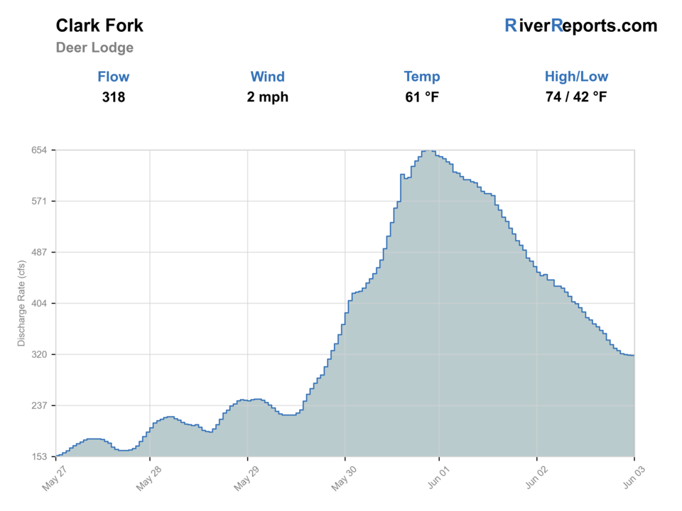
USGS data chart
Official USGS trend
Streamflow over the latest USGS reporting window.
Latest
320 cfs
Jun 3, 4 PM UTC
Weather
River weather report
Weather can change wading safety, road access, water temperature, hatches, and the best time of day to fish.
Live forecast loads as you reach this section
This keeps the report fast while still using the official National Weather Service forecast point.
Hatches and flies
Hatch chart and fly picks
Spring
BWOs, March Browns, midges
BWO emerger, March Brown, zebra midge, soft hackle
Early summer
Caddis, PMDs, stonefly leftovers
Sparkle caddis, PMD nymph, rubberleg, caddis pupa
Summer
Caddis and terrestrials
Hopper-dropper, ant, beetle, elk hair caddis
Fall
BWOs, mahoganies, streamer windows
Parachute BWO, mahogany dun, mini sculpin, leech
Valley-river nymphs
Pheasant tail, perdigon, zebra midge, rubberleg
Stable current and defined seams make depth and drift more important than fly size.
Terrestrials and caddis
Hopper, ant, beetle, elk hair caddis
Summer banks and evening windows give fish reason to slide toward the edges.
Small streamers
Sculpin, bugger, mini leech
Cloud cover, cooler fall days, or slightly colored water improve the swing or strip game.
Tactics
How to fish it
Decide first whether the river has enough clarity and shape to support real feeding lanes, then commit to the best seams rather than covering dead water.
Use Kohrs Bend or another named public access as the center of the day so you are not improvising legal entry in agricultural country.
Treat this as a thinking angler's river: soft inside bends, protected depth, and subtle current changes matter more than splashy hero water.
If the river looks wide, warm, and empty by late morning, believe that signal and move on.
Rigging
Rod, leader, and setup notes
A 4- to 6-weight rod handles most Deer Lodge Clark Fork fishing.
Carry 3X through 5X because the river can swing from colored and forgiving to clear and selective.
One indicator rig and one short streamer setup are enough for most days here.
Polarized glasses matter because reading soft edges and inside turns is more important than bombing long casts.
Access
Access and planning notes
Deer Lodge gauge check
Primary upper-valley decisionWade / float / trail
Gauge / wade / float
When to pick it
Start here when you need one reviewed trend before committing to a broad valley river that changes quickly with runoff and heat.
Caution
The gauge does not settle exact clarity at access points, soft-bank footing, or current restrictions for the day.
Kohrs Bend anchor
Named public accessWade / float / trail
Fishing access / short wade / launch
When to pick it
Use it when one improved public access point is better than guessing at roadside entry across private valley land.
Caution
A public access site does not make every nearby fence line, bridge shoulder, or field approach public.
One short valley reach
Low-risk seam planWade / float / trail
Road scout / short float / short wade
When to pick it
Pick this when the river has enough shape to fish one defined seam-and-soft-edge program instead of forcing the whole valley.
Caution
Do not turn a marginal river into a long float just because the gauge looks acceptable on paper.
Kohrs Bend is the most defensible public anchor for this route. Start there before chasing less-certain entry points.
Montana stream-access rights apply once you access the river legally, but they do not replace private-land respect around parking, fences, or bank entry.
This Deer Lodge page should not be confused with the Missoula Clark Fork page or the larger lower-river reaches near St. Regis.
Regulations
Check before fishing
Check Montana's current fishing regulations and any active closure or restriction notices before fishing. The upper Clark Fork can change quickly with runoff, heat, and seasonal management decisions.
Primary base
Deer Lodge
Best day style
Walk-wade and selective float planning from named public access on a broad valley river
Check first
RiverReports trend, USGS 12324200, Montana regulations and restrictions, and Deer Lodge weather
Safety
Runoff color swings, warm afternoons, soft valley banks, and private-land boundaries around access
Gear
Helpful gear for this water
4- to 6-weight rod
Enough rod for nymphs, dries, and compact streamers on a broad valley river.
Polarized glasses
Useful for reading subtle current edges and avoiding blind coverage of dead water.
Thermometer
Important once summer warmth reaches the valley floor.
Wading staff or cautious footing plan
Helpful where banks are soft and entry points are less obvious than on bouldery freestones.
Nearby water
Other water to research
Backup logic
Muddy runoff
Move to clearer tributary water or another river as soon as valley mud wipes out the soft edges and visibility you need.
Heat or restrictions
Fish only cool windows and pivot if trout-safe handling or active closure language no longer support the Deer Lodge reach.
Soft banks or unsafe wading
Treat unstable banks and pushy current as real fishability limiters and stop before the day becomes a rescue problem.
Access issue
Use only confirmed public access such as Kohrs Bend and pivot if roadside entry or shuttle details stay unclear.
Clark Fork River near Missoula
A larger, more urban Clark Fork comparison with different access and flow behavior.
Lower Clark Fork River
A downstream big-river option once you want St. Regis and below-town context.
Rock Creek
A more famous freestone backup if the upper valley Clark Fork looks too warm or too muddy.
FAQ
Fast answers
Is Clark Fork at Deer Lodge fishable today?
Clark Fork at Deer Lodge looks very fishable right now. The live score is 96/100, based on current flow, weather, public alerts, and the report's planning context. Recheck the linked gauge and forecast before leaving because conditions can change quickly after rain, heat, access changes, or flow swings.
What flow is best for Clark Fork at Deer Lodge?
Use RiverReports and USGS 12324200 near Deer Lodge together. Stable clear or slightly off-color flow that still leaves defined soft edges is the best signal; muddy runoff, hot low water, or a featureless flat glide should change the plan.
When should I skip Clark Fork at Deer Lodge?
Skip or pivot when runoff mud takes over, current restrictions are active, late-summer heat makes trout handling poor, or soft banks and broad current erase the safe seams you need.
Is Clark Fork at Deer Lodge safe to wade right now?
The fishability score is not a wading guarantee. Wade only where your chosen access has safe edges, clear footing, legal entry, and no forced crossings; high, rising, stained, or storm-affected water should be treated conservatively.
What should I check first on the Clark Fork at Deer Lodge?
Check RiverReports, USGS 12324200 near Deer Lodge, and current Montana restrictions before you commit to the drive or a float plan.
Where is the cleanest public starting point?
Kohrs Bend Fishing Access Site is the clearest named public access for this Deer Lodge-focused page.
Is this the same fishery as the Clark Fork near Missoula?
No. Deer Lodge is upper-valley Clark Fork water with more cleanup-history context, lighter use, and different access and temperature behavior than the Missoula reach.
Sources
Source set for this report
Reviewed 2026-05-31