
Montana / West
Lower Clark Fork River
A Lower Clark Fork report for anglers checking St. Regis flow, big-river access, trout and warmwater transitions, restrictions, and weather.
Image: Generated regional planning image for Lower Clark Fork River / BlueStreamFly generated; not exact location / BlueStreamFlyFishability now: Lower Clark Fork River fishability today
GreatData confidence: High96/100
Fishable now because St. Regis gauge is falling, weather is mild, and no public alert is active.
Flow observed
4:45 PM UTC
Weather observed
5:00 PM UTC
Score calculated
5:25 PM UTC
Why this rating
Flow
Weather
Public alerts
Next 6-12 hours
Improving / hold
A falling gauge and usable weather should keep the next 6-12 hours in play unless tributaries stain or heat builds.
USGS flow
20,700 cfs
Current trend: flow falling, rating likely holding strong unless weather or clarity changes.
More planning details: flies, flow bands, and live source checks
Fish it today
Start here
Start by deciding whether the day is a St. Regis river plan, a Superior-area float, or a lower dam-influenced trip. Then match flies, leaders, and species expectations to that exact reach.
Best flow clue
Use RiverReports and USGS 12354500 at St. Regis for the river reach, and avoid applying that gauge blindly to reservoir-influenced water farther downstream. Stable visibility is the best trout window; warm or slow lower water can shift the target to warmwater species.
Skip trigger
Skip or pivot when the exact lower reach is unclear, FWP restrictions are active, wind makes the boat plan unsafe, water is too warm for trout handling, or public access and takeout details are not confirmed.
Flow decision bands
Low clear trout window
Lower clear St. Regis flow can still fish for trout, but reach choice, heat, and mixed-species expectations should stay tighter than the graph alone suggests.
Best stable river reach
Stable visibility around the St. Regis gauge is the cleanest signal for a trout-focused float or edge-fishing plan before reservoir influence takes over farther downriver.
Pushy or unsafe
Big current, strong wind, or any reach that depends on uncertain launches, dams, or long exposed boat lanes should move the day to safer water.
Warm lower water and reservoir caution
A fishable-looking upstream graph does not override warm lower water, species changes, or reservoir influence that can make the day better for warmwater targets than trout.
USGS flow
20,700 cfs
Current trend: flow falling, rating likely holding strong unless weather or clarity changes.
Live USGS flow
20,600 cfs / falling about 16%
Live NWS forecast
64F / Sunny
Water temperature not verified
Heat guidance uses weather and river type unless an official water-temperature value is available.
No NWS alert flag
No active NWS alert was returned for this forecast point.
Use the St. Regis gauge for the river reach, and do not apply it blindly to reservoir sections.
Expect a mix of trout, pike, bass, and reservoir influence depending on how far downstream you go.
Check FWP rules, current restrictions, and consumption guidance before harvest.
Large water, wind, and dams make boat and wading plans more serious than casual roadside fishing.
Editorial review
How this report is maintained
This Lower Clark Fork River report is maintained from RiverReports and USGS St. Regis flow data, Montana FWP fishing regulations, current closure and restriction sources, stream-access law, weather, generated-image disclosure, and reach-specific lower-river planning guidance.
Byline
BlueStreamFly editorial team
Reviewed by
BlueStreamFly source review
Maintained by
Mountain Brook Run LLC
Last material review
2026-05-31
Report confidence
Good confidence
86/100
Good confidence: RiverReports, USGS St. Regis flow, Montana FWP regulation and restriction sources, stream-access law, weather, and generated-image disclosure are present. Confidence is moderated by broad reach scope, reservoir and dam influence, mixed species, and fewer concrete access anchors than some Montana pages.
Regulations
Montana FWP regulations and current restriction pages are linked for reach and species checks.
Flow support
RiverReports Clark Fork at St. Regis is backed by USGS 12354500 for the river reach.
Access support
Stream-access law is linked, but launch, takeout, dam, reservoir, and private-bank details remain reach-specific.
Weather and safety
The National Weather Service point resolved and the page calls out big current, wind, reservoirs, dams, heat, and boat logistics.
Angler usefulness
The page separates river versus reservoir water, trout versus warmwater species, reach choice, access, and backup-water decisions.
Editorial review
A public correction path, source standards page, generated-image disclosure, and public review history are included.
Fishability source review
2026-05-31 / material content or source review
RiverReports St. Regis flow support, USGS 12354500, Montana FWP fishing regulations, stream-access law, current restriction pages, the National Weather Service point, and image disclosure were rechecked before adding the Pine Creek-standard current-fishability layer.
2026-05-31
Upgraded the page to the Pine Creek fishability standard with reach-first decision bands, access cards, backup logic, and a reviewed route profile.
2026-05-28
Added St. Regis versus reservoir-reach trip framing, mixed-species and warm-water skip cues, wade-versus-float guidance, access nuance, backup-water suggestions, editorial review signals, generated-image disclosure context, and a page-specific report-confidence meter after source review.
2026-05-25
Initial source-reviewed report published with flows, weather, hatches, flies, tactics, access, regulations, and FAQs.
Angler planning edge
Local details that change the plan
Best for
Anglers planning the St. Regis, Superior, Plains, and downstream lower Clark Fork corridor with reach identity in mind, Trips where trout water, pike or bass water, reservoir influence, wind, and water temperature need to be separated before rigging, Boat or edge-fishing days when RiverReports, USGS, restrictions, and stream-access checks all look reasonable, Anglers comparing the lower Clark Fork with colder tributary-style options before committing to big lower water
Wade or float
Treat the Lower Clark Fork as a reach-first big-river report. Some edges can fish well, but boat logistics, dams, wind, reservoir influence, and private banks often matter more than a single fly pattern.
Best flows
Use RiverReports and USGS 12354500 at St. Regis for the river reach, and avoid applying that gauge blindly to reservoir-influenced water farther downstream. Stable visibility is the best trout window; warm or slow lower water can shift the target to warmwater species.
When to skip
Skip or pivot when the exact lower reach is unclear, FWP restrictions are active, wind makes the boat plan unsafe, water is too warm for trout handling, or public access and takeout details are not confirmed.
Local plan
Start by deciding whether the day is a St. Regis river plan, a Superior-area float, or a lower dam-influenced trip. Then match flies, leaders, and species expectations to that exact reach.
Pressure
Pressure is spread out on the lower river, but obvious launches and better trout-temperature windows concentrate anglers. A defined reach and backup access point usually matter more than covering extra miles.
Access nuance
Montana stream-access law supports river use below the ordinary high-water mark, but it does not solve private-bank entry, railroad, bridge, reservoir, or dam-area issues.
Backup water
If the Lower Clark Fork is warm, windy, unclear, or too reservoir-influenced for the goal, compare the Blackfoot for colder freestone water, the main Clark Fork near Missoula for a more familiar town reach, or Rock Creek for a wade-focused trout plan.
About the river
Setting, character, and why it fishes the way it does.
The lower Clark Fork is not the same fishing experience as the Missoula town reach. Downstream of major tributaries, the river gets bigger and eventually becomes influenced by dams and reservoirs.
Anglers may find trout-oriented seams, warmwater species, pike water, and broad boat runs depending on reach. That mix makes specificity important.
This report anchors the river near St. Regis and Superior so the flow module, access notes, and tactics stay useful instead of turning into a generic Clark Fork summary.
Target species
Rainbow and brown trout
Relevant in river reaches with cool enough water and current structure.
Westslope cutthroat trout
Release native cutthroat carefully where present under current rules.
Northern pike
Possible downstream and in slower water; FWP rules can differ from trout rules.
Bass and other warmwater fish
More relevant in reservoir-influenced sections and warmer lower water.
Reading the water
Stable river flow
Fish seams, bars, side channels, and bank structure with nymphs, dries, or streamers.
High water
Avoid heavy wading and focus on protected banks only if safe.
Warm lower water
Check temperature and shift away from trout if handling would be stressful.
Reservoir influence
Treat slower sections as a different fishery with wind, boat, and species changes.
Best seasons
Spring
Pre-runoff hatches and streamer windows can work, but flow changes are important.
Early summer
Runoff drop and caddis or stonefly activity can improve river reaches.
Summer
Hoppers, ants, and warmwater options matter, with temperature checks.
Fall
Cooling water brings BWOs, streamers, and more comfortable trout handling.
Preferred flow source
Clark Fork River at St. Regis
RiverReports is the preferred chart source when coverage exists. When a matching USGS gauge exists, keep it open as the official backstop for station data and current hydrograph context.
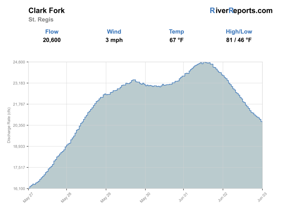
USGS data chart
Official USGS trend
Streamflow over the latest USGS reporting window.
Latest
20,600 cfs
Jun 3, 4 PM UTC
Weather
River weather report
Weather can change wading safety, road access, water temperature, hatches, and the best time of day to fish.
Live forecast loads as you reach this section
This keeps the report fast while still using the official National Weather Service forecast point.
Hatches and flies
Hatch chart and fly picks
March to April
Skwalas, March Browns, BWOs, midges, and early stonefly movement
Skwala dry, rubberleg, March Brown, BWO emerger, zebra midge
May to June
Runoff edges, salmonflies, golden stones, caddis, PMDs
Chubby Chernobyl, Pat's rubber legs, caddis pupa, PMD emerger, streamer
July to August
Hoppers, ants, beetles, nocturnal stones, spruce moths where present
Hopper-dropper, foam ant, beetle, nocturnal stone, small perdigon
September to October
Mahoganies, BWOs, October caddis, baitfish, fall streamer windows
Mahogany, BWO, October caddis, sculpin, leech
Stoneflies
Pat's rubber legs, Chubby Chernobyl, skwala, golden stone
Use before, during, and after stonefly movement or when trout sit tight to banks.
Mayflies and caddis
BWO, March Brown, PMD, caddis pupa, X-caddis
Use during spring and fall hatches or summer evening riffle feeding.
Terrestrials
Hoppers, ants, beetles, hopper-dropper rigs
Use during summer near grass, shade, undercuts, and slower bank seams.
Streamers
Sculpin, leech, sparkle minnow, small articulated streamer
Use in stained water, cloud cover, fall, or when larger trout hunt edges.
Tactics
How to fish it
Decide whether you are fishing a river reach or reservoir-influenced water before rigging.
Fish soft inside current, drop-offs, side channels, and bank seams on stable flows.
Use streamers for browns and pike in deeper or stained water.
On warm days, target smallmouth or pike instead of stressing trout in marginal temperatures.
If floating, account for wind, distance, takeouts, and dam-influenced water.
Rigging
Rod, leader, and setup notes
A 6-weight is the best all-around rod for big water, wind, streamers, and mixed species.
Carry trout leaders from 3X to 5X and heavier leaders or wire for pike water.
Use floating line for dries and a sink tip or intermediate line for streamers.
Bring a PFD for boat plans and a wading staff for large slippery edges.
Pack temperature and regulation checks into the plan before keeping fish.
Access
Access and planning notes
St. Regis gauge and river reach
Primary trout decisionWade / float / trail
Gauge / wade edge / float
When to pick it
Start here when you need one reviewed flow trend before deciding whether the lower river still fits a trout plan.
Caution
The gauge does not settle reservoir influence or downstream reach character by itself.
Superior to St. Regis corridor
Classic lower-river floatWade / float / trail
Boat / bank scout / reach choice
When to pick it
Use it when a river-style plan with clearer trout expectations fits better than the slower lower reaches.
Caution
Wind, private banks, and take-out certainty still decide whether the float is worth forcing.
Plains and reservoir-influenced water
Mixed-species fallbackWade / float / trail
Boat / bank / target change
When to pick it
Pick this when warmer slower water still offers a fishable day, but only if you are planning for the right species and conditions.
Caution
Do not use the St. Regis read as a precise safety or trout-quality signal for dam-influenced lower water.
Do not assume every lower-river bank is public. Use FWP access information and Montana stream-access rules.
Dams, reservoirs, and wind can change boat safety and fish behavior downstream.
Check consumption and harvest guidance before keeping fish from lower Clark Fork reaches.
Regulations
Check before fishing
Montana FWP regulations differ by Clark Fork reach and species. Check current rules, restrictions, and any advisory context before fishing or keeping fish.
Primary base
St. Regis, Superior, Plains, or Thompson Falls
Best day style
Large-river floats, FAS planning, wading edges, reservoir transition awareness
Check first
St. Regis flow, FWP restrictions, reach identity, access points, and weather
Safety
Big current, reservoirs, dams, private banks, wind, heat, and consumption advisories
Gear
Helpful gear for this water
5-weight rod
Covers dries, light nymphs, and most trout presentations.
6-weight rod
Better for wind, stonefly rigs, streamers, and hopper-dropper banks.
Wading staff
Useful in pushy freestone water, tailouts, slick ledges, and roadside access.
Thermometer
Check summer temperatures and stop trout fishing when handling becomes unsafe.
Nearby water
Other water to research
Backup logic
High or windy water
Leave the big lower-river float alone and compare the Blackfoot or another colder river when wind and current stack too much risk.
Heat
Switch to warmwater expectations or move to colder trout water when afternoon heat or active restrictions make trout handling questionable.
Reach mismatch
Reset the plan around one exact reach instead of treating St. Regis, Superior, and the lower reservoir water as one interchangeable fishery.
Access issue
Use only confirmed legal launches and bank entry and pivot if railroad, private-bank, or dam-area details are not clear.
Clark Fork River
The Missoula reach comparison for anglers staying closer to town.
Blackfoot River
A colder tributary-style freestone option when lower water is warm.
Rock Creek
A wade-focused creek alternative with stronger trout-water identity.
FAQ
Fast answers
Is Lower Clark Fork River fishable today?
Lower Clark Fork River looks very fishable right now. The live score is 96/100, based on current flow, weather, public alerts, and the report's planning context. Recheck the linked gauge and forecast before leaving because conditions can change quickly after rain, heat, access changes, or flow swings.
What flow is best for Lower Clark Fork River?
Use RiverReports and USGS 12354500 at St. Regis for the river reach, and avoid applying that gauge blindly to reservoir-influenced water farther downstream. Stable visibility is the best trout window; warm or slow lower water can shift the target to warmwater species.
When should I skip Lower Clark Fork River?
Skip or pivot when the exact lower reach is unclear, FWP restrictions are active, wind makes the boat plan unsafe, water is too warm for trout handling, or public access and takeout details are not confirmed.
Is Lower Clark Fork River safe to wade right now?
The fishability score is not a wading guarantee. Wade only where your chosen access has safe edges, clear footing, legal entry, and no forced crossings; high, rising, stained, or storm-affected water should be treated conservatively.
What should I check first before fishing the Lower Clark Fork River?
Check the St. Regis gauge, exact reach, FWP restrictions, weather, access, and any harvest or consumption guidance.
Are there special regulations on the Lower Clark Fork River?
Yes. Lower Clark Fork rules vary by reach and species, especially as the river transitions toward reservoir water.
What flies should I bring for the Lower Clark Fork River?
Bring the hatch-chart flies, a few confidence nymphs, and a streamer box. Then adjust for water temperature, clarity, and the insects you actually see.
Can I wade the Lower Clark Fork River?
Some edges are wadeable, but it is big water. Use official access and avoid assuming private banks are available.
When should I skip the Lower Clark Fork River?
Skip it when flows are unsafe, temperatures stress trout, wildfire or emergency closures are active, or legal access for the reach is not clear.
Sources
Source set for this report
Reviewed 2026-05-31