Montana / West
Clark Fork River
A Clark Fork River report for Missoula anglers checking below-town flow, freestone tactics, access, heat restrictions, and current Montana rules.
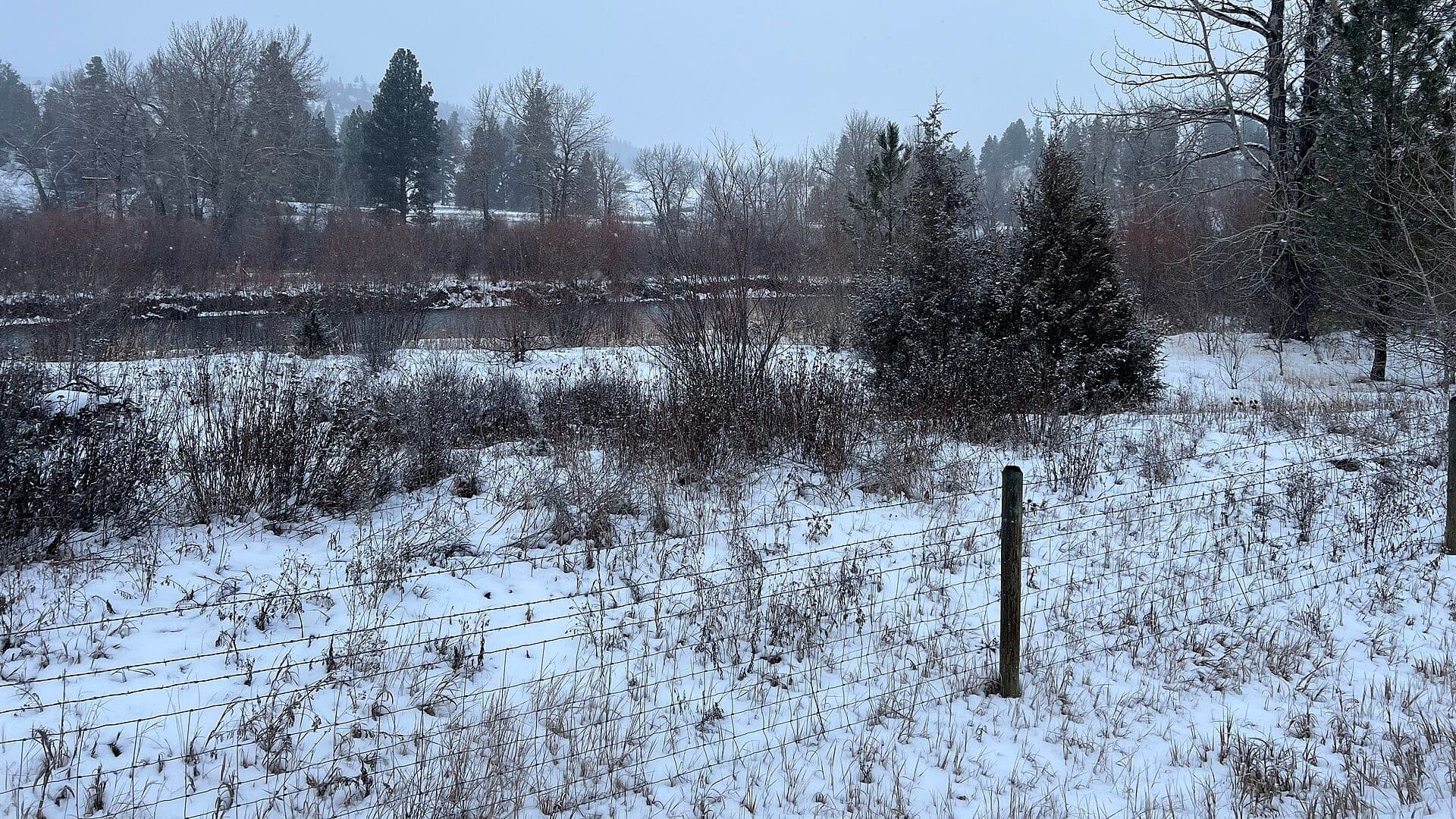
Image: Clark Fork River behind the Bearmouth Rest Area / CC BY 4.0 / PinchyCCFishability now: Clark Fork River fishability today
GreatData confidence: High96/100
Fishable now because the live gauge is falling, weather is mild, and no public alert is active.
Flow observed
3:00 PM UTC
Weather observed
4:00 PM UTC
Score calculated
4:20 PM UTC
Why this rating
Flow
Weather
Public alerts
Next 6-12 hours
Improving / hold
A falling gauge and usable weather should keep the next 6-12 hours in play unless tributaries stain or heat builds.
USGS flow
16,200 cfs
Current trend: flow falling, rating likely holding strong unless weather or clarity changes.
More planning details: flies, flow bands, and live source checks
Fish it today
Start here
Start by choosing town water, below-town water, or a downstream float. Match flies and safety to that reach instead of applying one Clark Fork plan to the whole drainage.
Best flow clue
Use RiverReports and USGS 12353000 below Missoula together. Stable or dropping flow with improving clarity is the better window; big, brown, rising, or warm water should push the plan to softer banks or another river.
Skip trigger
Skip or narrow the plan when FWP restrictions are active, tributary color makes the reach unreadable, heat compromises trout handling, or parking and legal river entry are unclear.
Flow decision bands
Low but still fishable
Low clear Clark Fork water can still fish, but heat, bridge pressure, and trout handling should tighten the plan to the best cool reach and a shorter session.
Best stable-clearing window
Stable or slowly dropping below-Missoula flow with improving tributary clarity is the cleanest signal for dry-dropper, caddis, hopper, and short streamer water.
Pushy or unsafe
Big brown runoff, fast side channels, or any reach that depends on uncertain wades, urban edges, or float exits should move the day to softer banks or another river.
Heat and tributary color caution
A usable gauge does not override hot afternoons, FWP restrictions, or a colored tributary pushing one Clark Fork reach well behind another.
USGS flow
16,200 cfs
Current trend: flow falling, rating likely holding strong unless weather or clarity changes.
Live USGS flow
16,200 cfs / falling about 25%
Live NWS forecast
60F / Sunny
Water temperature not verified
Heat guidance uses weather and river type unless an official water-temperature value is available.
No NWS alert flag
No active NWS alert was returned for this forecast point.
Use the below-Missoula gauge for the main page flow trend and watch tributary clarity.
Fish soft banks, riffles, and side channels instead of heavy middle current during high water.
Summer heat can trigger FWP restrictions, so carry a thermometer and fish early.
The Alberton Gorge is a different whitewater-style plan from casual town wading.
Editorial review
How this report is maintained
This Clark Fork River report is maintained from RiverReports and USGS below-Missoula flow data, Montana FWP fishing regulations, current closure and restriction sources, stream-access law, weather, media-credit, and Missoula-area freestone planning sources.
Byline
BlueStreamFly editorial team
Reviewed by
BlueStreamFly source review
Maintained by
Mountain Brook Run LLC
Last material review
2026-05-31
Report confidence
Good confidence
88/100
Good confidence: RiverReports, USGS below-Missoula flow, Montana FWP regulation and restriction sources, stream-access law, weather, and image credit are present. Confidence is moderated by the Clark Fork's size, tributary-driven clarity swings, urban access variability, and broad reach differences below Missoula.
Regulations
Montana FWP regulations and current restriction pages are linked for exact-reach checks.
Flow support
RiverReports Clark Fork below Missoula is backed by USGS 12353000.
Access support
Stream-access law is linked, but the page has fewer concrete FAS anchors and access remains reach-specific around town, bridges, and private land.
Weather and safety
The National Weather Service point resolved and the page calls out big water, runoff, heat stress, urban hazards, and gorge separation.
Angler usefulness
The page separates town water, below-town flow, tributary clarity, access, heat, and backup-water choices.
Editorial review
A public correction path, source standards page, image credit, and public review history are included.
Fishability source review
2026-05-31 / material content or source review
RiverReports below-Missoula flow support, USGS 12353000, Montana FWP fishing regulations, stream-access law, current closure and restriction pages, the National Weather Service point, and image credit were rechecked before adding the Pine Creek-standard current-fishability layer.
2026-05-31
Upgraded the page to the Pine Creek fishability standard with reach-aware decision bands, access cards, backup logic, and a reviewed route profile.
2026-05-28
Added Missoula-reach trip fit, town-versus-downstream framing, runoff and warm-water skip cues, access and private-bank nuance, backup-water suggestions, editorial review signals, and a page-specific report-confidence meter after source review.
2026-05-25
Initial source-reviewed report published with flows, weather, hatches, flies, tactics, access, regulations, and FAQs.
Angler planning edge
Local details that change the plan
Best for
Missoula-area anglers deciding between town water, below-town riffles, and downstream float water, Trips where tributary clarity, below-Missoula flow, FWP restrictions, heat, and legal access all shape the day, Freestone dry-dropper, hopper, caddis, PMD, and streamer plans when the big river is stable enough to read, Anglers comparing the Clark Fork with the Blackfoot, Bitterroot, and Rock Creek before committing to one valley
Wade or float
Treat the Clark Fork as mixed bank, wade, and float water, but choose the reach first. Town edges, below-town riffles, and Alberton-style water are different plans with different access and safety demands.
Best flows
Use RiverReports and USGS 12353000 below Missoula together. Stable or dropping flow with improving clarity is the better window; big, brown, rising, or warm water should push the plan to softer banks or another river.
When to skip
Skip or narrow the plan when FWP restrictions are active, tributary color makes the reach unreadable, heat compromises trout handling, or parking and legal river entry are unclear.
Local plan
Start by choosing town water, below-town water, or a downstream float. Match flies and safety to that reach instead of applying one Clark Fork plan to the whole drainage.
Pressure
Pressure is highest around Missoula bridges, obvious launches, and comfortable summer evenings. A clear access plan and willingness to move away from the first lot help more than fishing through crowds.
Access nuance
FWP stream-access law supports below-high-water river use, but it does not allow trespass across private banks, railroad edges, bridge infrastructure, or closed access.
Backup water
If the Clark Fork is high, dirty, warm, or crowded, compare the Blackfoot for colder freestone water, the Bitterroot for a valley hatch plan, or Rock Creek for a more wade-focused day.
About the river
Setting, character, and why it fishes the way it does.
The Clark Fork drains a large piece of western Montana and runs through Missoula before bending downstream toward Alberton, Superior, and the lower drainage. It is not one uniform river.
Near Missoula, anglers get a mix of town access, big riffles, side channels, bank seams, and float water shaped by the Blackfoot and Bitterroot. That makes flow and clarity checks essential.
A helpful Clark Fork plan starts with reach choice. Town water, below-town riffles, and gorge-style water require different access, boats, tactics, and safety judgment.
Target species
Rainbow and hybrid trout
Common targets in riffles, seams, and bank water when flows and temperature cooperate.
Brown trout
More likely around deeper bends, undercuts, and low-light streamer water.
Westslope cutthroat trout
Present in the drainage; release native cutthroat carefully under current rules.
Northern pike
Possible in some reaches; FWP rules may differ from trout rules, so check before harvest.
Reading the water
Dropping post-runoff
Fish banks, side channels, soft riffles, rubberlegs, and streamers.
Clear summer flow
Use caddis, PMDs, hoppers, ants, and small droppers through riffles and banks.
Rising or stained
Fish edges only if safe and avoid wading pushy crossings.
Warm low water
Check restrictions and switch to early mornings or another river if trout are stressed.
Best seasons
Spring
Skwalas, March Browns, olives, and pre-runoff windows can fish well.
Early summer
Runoff drop brings stonefly, caddis, PMD, and streamer opportunities.
Summer
Hoppers, ants, caddis, and evening riffles matter, with temperature checks.
Fall
BWOs, mahoganies, October caddis, and streamers are practical.
Preferred flow source
Clark Fork River below Missoula
RiverReports is the preferred chart source when coverage exists. When a matching USGS gauge exists, keep it open as the official backstop for station data and current hydrograph context.
USGS data chart
Official USGS trend
Streamflow over the latest USGS reporting window.
Latest
16,200 cfs
Jun 3, 3 PM UTC
Weather
River weather report
Weather can change wading safety, road access, water temperature, hatches, and the best time of day to fish.
Live forecast loads as you reach this section
This keeps the report fast while still using the official National Weather Service forecast point.
Hatches and flies
Hatch chart and fly picks
March to April
Skwalas, March Browns, BWOs, midges, and early stonefly movement
Skwala dry, rubberleg, March Brown, BWO emerger, zebra midge
May to June
Runoff edges, salmonflies, golden stones, caddis, PMDs
Chubby Chernobyl, Pat's rubber legs, caddis pupa, PMD emerger, streamer
July to August
Hoppers, ants, beetles, nocturnal stones, spruce moths where present
Hopper-dropper, foam ant, beetle, nocturnal stone, small perdigon
September to October
Mahoganies, BWOs, October caddis, baitfish, fall streamer windows
Mahogany, BWO, October caddis, sculpin, leech
Stoneflies
Pat's rubber legs, Chubby Chernobyl, skwala, golden stone
Use before, during, and after stonefly movement or when trout sit tight to banks.
Mayflies and caddis
BWO, March Brown, PMD, caddis pupa, X-caddis
Use during spring and fall hatches or summer evening riffle feeding.
Terrestrials
Hoppers, ants, beetles, hopper-dropper rigs
Use during summer near grass, shade, undercuts, and slower bank seams.
Streamers
Sculpin, leech, sparkle minnow, small articulated streamer
Use in stained water, cloud cover, fall, or when larger trout hunt edges.
Tactics
How to fish it
Pick a reach first: town, below-town, or downstream float water each fishes differently.
Fish inside bends and soft bank seams before stepping into heavy current.
Use dry-droppers on broken riffles and single dries when pods feed in slicks.
Streamer fish clouds, stain, and deeper bank lines with a controlled swing or strip.
Give other anglers, boats, and town users room around popular bridges and access points.
Rigging
Rod, leader, and setup notes
A 5-weight works for dries and nymphs; a 6-weight helps with wind, hoppers, and streamers.
Carry 3X to 5X tippet for hoppers, caddis, and nymph rigs.
Use a short stout leader for streamers and avoid over-weighted rigs in fast wading water.
Pack a thermometer, polarized glasses, wading staff, and a plan for legal parking.
If floating, confirm launch, takeout, and skill level before committing to gorge-style water.
Access
Access and planning notes
Below-Missoula gauge check
Primary flow decisionWade / float / trail
Gauge / bank / wade / float
When to pick it
Start here when tributary color and the main-stem trend decide whether the Clark Fork is worth fishing at all.
Caution
One gauge does not settle every bridge access, town edge, or lower-river clarity question.
Missoula bridge and town edges
Fast after-work planWade / float / trail
Bank / short wade / urban scout
When to pick it
Use these when parking, quick access, and a short defined session matter more than covering the whole drainage.
Caution
Crowding, private edges, railroad infrastructure, and bridge hazards still require exact judgment.
Alberton and downstream float water
Longer reach swapWade / float / trail
Float / bank scout / reach change
When to pick it
Pick this when town water is crowded or tributary color makes a downstream reach the smarter option.
Caution
Do not assume a downstream float automatically fixes heat, clarity, or access uncertainty.
Montana stream access allows use below ordinary high-water marks, but it does not grant access across private land.
Bridge and town access can be crowded. Park legally and avoid cutting banks or trespassing.
Check current FWP restrictions and fish-consumption guidance before keeping fish from Clark Fork drainage reaches.
Regulations
Check before fishing
Montana FWP regulations and current restrictions control trout, pike, harvest, methods, closures, and temperature-related limits. Check the current rules for the exact reach.
Primary base
Missoula, Bonner, Frenchtown, or Alberton
Best day style
Town bridges, FAS sites, floats, wading edges, and private-bank awareness
Check first
Below-Missoula flow, clarity, FWP restrictions, tributary influence, and weather
Safety
Big water, runoff, urban hazards, private banks, heat stress, and Alberton Gorge separation
Gear
Helpful gear for this water
5-weight rod
Covers dries, light nymphs, and most trout presentations.
6-weight rod
Better for wind, stonefly rigs, streamers, and hopper-dropper banks.
Wading staff
Useful in pushy freestone water, tailouts, slick ledges, and roadside access.
Thermometer
Check summer temperatures and stop trout fishing when handling becomes unsafe.
Nearby water
Other water to research
Backup logic
High or muddy water
Skip marginal crossings and compare the Blackfoot or Rock Creek when the Clark Fork is still too pushy or off-color to read safely.
Heat or restrictions
Fish only cool legal windows and move to colder water when afternoon heat or active FWP restrictions make trout handling questionable.
Crowding
Leave the first bridge lot, shorten the session, or swap to a different valley instead of forcing crowded town edges.
Access issue
Use only confirmed legal public entry and pivot if private banks, railroad edges, or parking rules make the reach unclear.
Blackfoot River
A colder freestone tributary option east of Missoula.
Bitterroot River
A valley freestone with a different clarity and hatch rhythm.
Rock Creek
A wade-focused nearby creek with strong stonefly and access planning.
FAQ
Fast answers
Is Clark Fork River fishable today?
Clark Fork River looks very fishable right now. The live score is 96/100, based on current flow, weather, public alerts, and the report's planning context. Recheck the linked gauge and forecast before leaving because conditions can change quickly after rain, heat, access changes, or flow swings.
What flow is best for Clark Fork River?
Use RiverReports and USGS 12353000 below Missoula together. Stable or dropping flow with improving clarity is the better window; big, brown, rising, or warm water should push the plan to softer banks or another river.
When should I skip Clark Fork River?
Skip or narrow the plan when FWP restrictions are active, tributary color makes the reach unreadable, heat compromises trout handling, or parking and legal river entry are unclear.
Is Clark Fork River safe to wade right now?
The fishability score is not a wading guarantee. Wade only where your chosen access has safe edges, clear footing, legal entry, and no forced crossings; high, rising, stained, or storm-affected water should be treated conservatively.
What should I check first before fishing the Clark Fork River?
Check the below-Missoula gauge, clarity, FWP current restrictions, weather, and your exact access point.
Are there special regulations on the Clark Fork River?
Yes. The Clark Fork has reach-specific rules and current restrictions can change during heat, fire, or emergency events.
What flies should I bring for the Clark Fork River?
Bring the hatch-chart flies, a few confidence nymphs, and a streamer box. Then adjust for water temperature, clarity, and the insects you actually see.
Can I wade the Clark Fork River?
Yes around some public access, but the river is large and pushy. Use official access and avoid crossing private land.
When should I skip the Clark Fork River?
Skip it when flows are unsafe, temperatures stress trout, wildfire or emergency closures are active, or legal access for the reach is not clear.
Sources
Source set for this report
Reviewed 2026-05-31