Minnesota / Midwest
Whitewater River
A Whitewater River report for southeastern Minnesota trout anglers checking stream conditions, fork access, hatches, weather, and special rules.
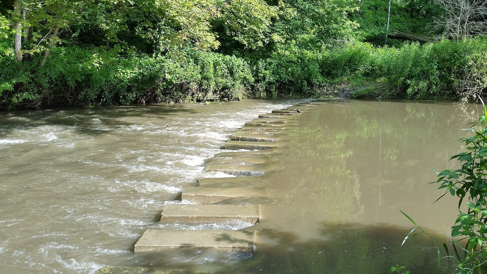
Image: Whitewater River - 53052827802 / CC BY-SA 2.0 / Joe PasseFishability now: Whitewater River fishability today
UnknownData confidence: Medium44/100
Check live sources first because flow has been checked, weather is usable, and no public alert is active.
Flow observed
Not returned
Weather observed
5:00 PM UTC
Score calculated
5:25 PM UTC
Why this rating
Flow
Weather
Public alerts
Next 6-12 hours
Hold
Wait for a better live check before committing the drive or choosing a wading plan.
Flow check
No live chart
Current trend: previous-score comparison will become more useful after repeated live checks.
More planning details: flies, flow bands, and live source checks
Fish it today
Start here
Start with DNR stream conditions, the trout map, and Whitewater State Park or fork-specific access, then choose small nymphs and dries for clear water or light streamers only after mild stain.
Best flow clue
Use DNR stream-condition updates and rainfall first. The USGS Whitewater station is useful context, but this report does not treat it as a dependable current cfs reading for every trout reach.
Skip trigger
Skip the creek when bluff-country storms have stained the water, banks are muddy, the stream is rising, water is warm, or the exact fork and access boundary are unclear.
Flow decision bands
Clear to off-color, normal flow
DNR stream conditions, recent rainfall, and visible clarity should all support the exact fork before this becomes a good trout plan.
Bluff-country storm rise
High, muddy, or rising water should move the day to scouting or a different stream because the Whitewater system changes fast after rain.
Low clear technical water
Fish early or shaded water with small flies, longer leaders, and careful temperature checks.
Park or easement pressure
A fishable creek can still be a weak trip when the state park, crossings, or easy easements are crowded or access-limited.
Flow check
No live chart
Current trend: previous-score comparison will become more useful after repeated live checks.
No structured live flow
Use the linked flow and access sources before deciding.
Live NWS forecast
78F / Sunny
Water temperature not verified
Heat guidance uses weather and river type unless an official water-temperature value is available.
No NWS alert flag
No active NWS alert was returned for this forecast point.
Do not rely on stale Whitewater cfs data; check DNR stream conditions and recent rainfall first.
Fork names matter. Whitewater State Park, Middle Fork, North Fork, and lower reaches fish differently.
Clear low water calls for small flies and careful approaches; stain can open streamer windows.
After storms, bluffs and valleys can move water quickly, so safety comes before the drive.
Editorial review
How this report is maintained
This report is maintained from current regulation, access, flow, weather, and public planning sources so anglers can make better trip decisions than a raw gauge or generic overview would allow.
Byline
BlueStreamFly editorial team
Reviewed by
BlueStreamFly source review
Maintained by
Mountain Brook Run LLC
Last material review
2026-06-02
Report confidence
Good confidence
83/100
Good confidence: Minnesota DNR stream conditions, trout maps, state-park and water-trail context, fishing regulations, USGS station context, weather data, and route-specific Whitewater guidance support the page. Confidence is moderated by no dependable current reach gauge, fork-to-fork differences, storm response, crowding, and summer water temperature.
Regulations
Minnesota fishing regulations and trout map sources support the legal-check path for forks and easements.
Access
Whitewater State Park, DNR trout maps, and water-trail context support public planning, with exact fork access still requiring confirmation.
Flow and weather
DNR stream-condition reports and USGS station context are useful, but no dependable current live discharge feed is verified for every trout reach.
Fishing usefulness
The page now separates fork choice, no-gauge clarity checks, state-park access, easements, storm response, warm-water restraint, and backup-water decisions.
Fishability dashboard and source review
2026-06-02 / material content or source review
Minnesota DNR southeast stream-condition updates, trout stream maps, fishing regulations, Whitewater State Park and water-trail context, USGS station context, National Weather Service point data, and fork-specific Driftless planning sources were checked before updating the current-fishability decision layer.
2026-06-02
Added the current-fishability dashboard with no-live-gauge decision bands, fork and park access cards, storm and warm-water backup cues, stable fishability SEO, and confidence signals.
2026-05-29
Added Whitewater River trip-fit guidance, DNR stream-condition framing, official source context for the no-current-gauge panel, fork and easement access nuance, bluff-country rain safety, backup-water suggestions, editorial review signals, and a page-specific report-confidence meter after source review.
2026-05-24
Initial source-reviewed report published with flows, weather, hatches, flies, tactics, access, regulations, and FAQs.
Angler planning edge
Local details that change the plan
Best for
Driftless trout anglers choosing between Whitewater State Park, Middle Fork, North Fork, and lower-river context, Small-stream days where DNR stream conditions, rain timing, and legal trout access matter before fly choice, Clear-water dry-dropper, scud, BWO, caddis, terrestrial, and light-streamer fishing with quiet approaches, Anglers who will carry a thermometer and move off trout water when summer flows get low or warm
Wade or float
Treat the Whitewater as wade-first trout water. Fork choice, legal easement or park access, and recent rain decide whether a short careful session makes sense.
Best flows
Use DNR stream-condition updates and rainfall first. The USGS Whitewater station is useful context, but this report does not treat it as a dependable current cfs reading for every trout reach.
When to skip
Skip the creek when bluff-country storms have stained the water, banks are muddy, the stream is rising, water is warm, or the exact fork and access boundary are unclear.
Local plan
Start with DNR stream conditions, the trout map, and Whitewater State Park or fork-specific access, then choose small nymphs and dries for clear water or light streamers only after mild stain.
Pressure
Pressure concentrates near the state park, easy road crossings, and named pools during good spring and early-summer conditions. A second legal access plan helps avoid crowding.
Access nuance
DNR maps, state park information, and trout easements are the access anchors. Stay within mapped public corridors and avoid assuming a bridge or farm lane is permission to roam.
Backup water
If the Whitewater is muddy, warm, or crowded, compare the South Fork Root, South Branch Root, or St. Croix before forcing a poor trout-stream day.
About the river
Setting, character, and why it fishes the way it does.
The Whitewater River system drains bluff country in southeastern Minnesota and includes cold trout water, state park access, forked tributary planning, and a lower river corridor.
Its fishing character is classic Driftless but less simple than a single access name. Spring influence, clear pools, pasture edges, wooded cover, and storm response all affect where and how you fish.
This report is intentionally transparent about the flow source. A stale gauge is worse than no gauge, so the page points anglers toward DNR stream conditions, trout maps, and real-time weather checks.
Target species
Brown trout
The main trout target in many reaches, especially around undercuts, bends, and deeper cover.
Rainbow trout
Possible in managed areas; verify current stocking and rules.
Brook trout
Possible in colder fork or tributary influence; handle native fish carefully.
Warmwater fish
More relevant in lower sections and not the focus of the trout-stream plan.
Reading the water
Clear and stable
Fish small dries, scuds, pheasant tails, and caddis with quiet approaches.
Light stain
Use small streamers or larger nymphs around banks and deeper bends.
Muddy or rising
Skip the creek. Bluff-country water and banks can become unsafe quickly.
Warm summer water
Fish early, stay near cold influence, and stop trout handling when temperatures climb.
Best seasons
Spring
Strong nymph, BWO, caddis, and high-clarity trout window.
Early summer
Caddis, sulphurs, terrestrials, and dry-dropper fishing can be productive.
Late summer
Use early starts, shade, terrestrials, and temperature checks.
Fall and winter
Midges, BWOs, scuds, and small streamers can work during legal seasons.
Flow
Whitewater River reach conditions
A dependable current discharge reading was not verified for the Whitewater fishing reach. Use Minnesota DNR stream-condition updates, recent rainfall, fork-specific access information, and on-site clarity before fishing.
Official water source
USGS Whitewater River near Beaver and DNR stream-condition context
Use the USGS station as official water-source context, then make the fishing call from current DNR stream conditions, recent rain, and the exact fork you plan to fish.
Open official sourceWeather
River weather report
Weather can change wading safety, road access, water temperature, hatches, and the best time of day to fish.
Live forecast loads as you reach this section
This keeps the report fast while still using the official National Weather Service forecast point.
Hatches and flies
Hatch chart and fly picks
March to April
Midges, early black stones, BWOs, scuds, and small olives
Zebra midge, scud, black stonefly, BWO emerger, pheasant tail
May to June
Caddis, sulphurs, March Browns, crane flies, light mayflies
Elk hair caddis, caddis pupa, sulphur, March Brown, crane fly larva
July to September
Terrestrials, tricos, small olives, hoppers, beetles, ants
Foam ant, beetle, small hopper, trico spinner, dry-dropper
Fall and winter
BWOs, midges, scuds, small streamers in stained water
BWO, zebra midge, scud, pink squirrel, small leech
Nymphs
Pheasant tail, hare's ear, caddis pupa, zebra midge, stonefly
Use when trout are not rising or when broken water hides subsurface feeding.
Dry flies
BWO, Hendrickson, sulphur, caddis, parachute Adams, terrestrial
Use during visible hatches, spinner falls, or quiet bank feeders.
Streamers
Sculpin, leech, woolly bugger, small baitfish
Use in stained water, higher flows, low light, or deeper cover.
Soft hackles
Partridge and orange, pheasant tail soft hackle, caddis soft hackle
Swing through riffles and tailouts when insects are moving but rises are hard to read.
Tactics
How to fish it
Check the fork and access before picking flies; the same river name can mean very different water.
Use small nymphs and scuds first when fish are not visibly rising.
Fish terrestrials tight to grass and brush in summer, especially with a light breeze.
Use small streamers after light stain, but do not fish through unsafe muddy water.
Move slowly in clear pools and give pressured state-park fish extra distance.
Rigging
Rod, leader, and setup notes
A 3-weight or 4-weight is ideal for most Whitewater trout water.
Use 5X to 6X for clear-water dries and 4X for small streamers.
Carry dry-dropper, light indicator, and tight-line options rather than one heavy rig.
Bring scuds, midges, BWOs, caddis, terrestrials, and a few size 10 to 12 streamers.
Studded boots help, but do not cut banks or create erosion on soft approaches.
Access
Access and planning notes
Whitewater State Park
Most defined public startWade / float / trail
Park / wade / short walks
When to pick it
Start here when park access, stream conditions, and water temperature support a simple legal session.
Caution
Park access does not mean every fork or nearby bank has the same rules, crowd level, or water clarity.
Middle and North Fork checks
Fork selectionWade / float / trail
DNR map / road scout / wade
When to pick it
Use them when one fork has better clarity or temperature than the broader system.
Caution
Forks can differ sharply after storms; do not assume one DNR note describes every reach.
Mapped trout easements
Quiet Driftless waterWade / float / trail
DNR trout map / wade
When to pick it
Pick these when map boundaries and signs are clear and the water is not too warm or muddy.
Caution
Stay inside easements and avoid treating farm lanes or bridge shoulders as permission.
Use DNR maps, state park information, and trout easements. Private land is common outside mapped access.
Recent rain can change the river faster than a stale gauge page can help you.
Fork naming matters for directions, regulations, and expectations. Confirm which Whitewater reach you are fishing.
Regulations
Check before fishing
Minnesota trout rules and special regulation reaches apply by water and section. Check current DNR regulations, trout maps, and park information before fishing.
Primary base
Elba, St. Charles, or Rochester
Best day style
State park, trout easements, road crossings, small-stream wading, and fork-specific planning
Check first
DNR stream conditions, trout maps, recent rain, park access, and rules
Safety
Flashy rain response, muddy banks, bluff roads, private land, and cold spring water
Gear
Helpful gear for this water
4-weight or 5-weight rod
Best for trout dries, nymphs, and light streamers.
6-weight rod
Useful for streamers, wind, bigger water, and mixed trout or bass reaches.
Thermometer
Check before handling trout in warm, low, or late-summer water.
Studded boots
Helpful on slick cobble, limestone, tailwater ledges, and shaded rocks.
Nearby water
Other water to research
Backup logic
Muddy after storms
Compare South Branch Root, South Fork Root, or another DNR-reported clear stream before fishing stained Whitewater water.
Warm trout water
Fish only a short cool window or move to colder water instead of extending trout handling.
State park crowding
Use another mapped access, switch forks, or choose a different Driftless route.
Access uncertainty
Use park and DNR map access only; do not guess at private road or pasture entries.
Root River, South Fork
A nearby Driftless trout option with a downstream flow proxy.
South Branch Root River
Another trout-stream plan where rain and easements matter.
St. Croix River
A smallmouth and scenic-river backup when trout streams are off-color.
FAQ
Fast answers
Is Whitewater River fishable today?
Whitewater River needs a live-condition check before you commit. The live score is 44/100, based on current flow, weather, public alerts, and the report's planning context. Recheck the linked gauge and forecast before leaving because conditions can change quickly after rain, heat, access changes, or flow swings.
What flow is best for Whitewater River?
Use DNR stream-condition updates and rainfall first. The USGS Whitewater station is useful context, but this report does not treat it as a dependable current cfs reading for every trout reach.
When should I skip Whitewater River?
Skip the creek when bluff-country storms have stained the water, banks are muddy, the stream is rising, water is warm, or the exact fork and access boundary are unclear.
Is Whitewater River safe to wade right now?
The fishability score is not a wading guarantee. Wade only where your chosen access has safe edges, clear footing, legal entry, and no forced crossings; high, rising, stained, or storm-affected water should be treated conservatively.
What should I check first before fishing the Whitewater River?
Check DNR stream conditions, recent rain, trout maps, park access, and the exact fork before fishing.
Are there special regulations on the Whitewater River?
Yes. Minnesota trout regulations and special reaches can apply, so check the current rule PDF and maps.
Is the Whitewater River a good fly-fishing river?
Yes, if you match the reach, season, target species, water temperature, and current access rules. This report is built to help you choose that plan.
What flies should I bring for the Whitewater River?
Bring the hatch-chart flies, confidence nymphs, and a backup streamer or warmwater box so you can adjust to flow, clarity, and temperature.
How should I plan access for the Whitewater River?
Use Whitewater State Park information, DNR trout easements, water-trail pages, and legal road access.
Sources
Source set for this report
Reviewed 2026-06-02