
Minnesota / Midwest
Root River, South Fork
A South Fork Root River report for Driftless trout anglers checking Houston flow, MN stream conditions, hatches, access, and special rules.
Image: Generated regional planning image for Root River, South Fork / BlueStreamFly generated; not exact location / BlueStreamFlyFishability now: Root River, South Fork fishability today
GreatData confidence: High91/100
Fishable now because South Park gauge is stable, weather is usable, and no public alert is active.
Flow observed
4:30 PM UTC
Weather observed
5:00 PM UTC
Score calculated
5:24 PM UTC
Why this rating
Flow
Weather
Public alerts
Next 6-12 hours
Hold
Stable live data supports staying with the plan, but recheck the gauge and forecast before leaving.
USGS flow
161 cfs
Current trend: flow stable, so weather, temperature, and access checks drive the next change.
More planning details: flies, flow bands, and live source checks
Fish it today
Start here
Check the trout map first, then pair the Houston trend, Lanesboro conditions, rainfall, and a specific legal easement before choosing small dries, scuds, or light streamers.
Best flow clue
Use RiverReports and USGS 05385500 near Houston as downstream trend context, then compare Lanesboro stream conditions and recent rainfall before judging upper reaches.
Skip trigger
Skip or choose a safer creek when storms have stained the valley, banks are muddy, temperature is high, or the mapped easement and rule section are not clear.
Flow decision bands
Low but fishable
Low clear Driftless water can fish with scuds, small dries, and stealth when temperatures stay safe.
Best Driftless trout window
Stable or slowly falling Houston trend, clear Lanesboro conditions, cool weather, and confirmed easements make the best trout signal.
Pushy or unsafe
Storm-stained valleys, muddy banks, or rising water should move anglers to another mapped creek or a later day.
Gauge-proxy caution
Houston is useful downstream context, but upper South Fork reaches still need rainfall, clarity, and easement checks.
USGS flow
161 cfs
Current trend: flow stable, so weather, temperature, and access checks drive the next change.
Live USGS flow
161 cfs / stable
Live NWS forecast
76F / Sunny
Water temperature not verified
Heat guidance uses weather and river type unless an official water-temperature value is available.
No NWS alert flag
No active NWS alert was returned for this forecast point.
Use RiverReports/USGS 05385500 as a condition proxy, not a perfect reading for every upper reach.
Check Minnesota trout maps and Lanesboro stream conditions before choosing a section.
Small flies, careful wading, and short casts often beat heavy rigs in clear water.
After storms, the river can stain and rise quickly; move to safer water or wait for clarity.
Editorial review
How this report is maintained
This report is maintained from current regulation, access, flow, weather, and public planning sources so anglers can make better trip decisions than a raw gauge or generic overview would allow.
Byline
BlueStreamFly editorial team
Reviewed by
BlueStreamFly source review
Maintained by
Mountain Brook Run LLC
Last material review
2026-05-31
Report confidence
Good confidence
84/100
Good confidence: RiverReports, USGS 05385500, Minnesota regulations, trout maps, Lanesboro stream conditions, weather, and media support the report. Confidence is moderated because the gauge is downstream context, not an exact reading for every trout reach.
Regulations
Minnesota regulations and trout stream maps support special-rule and easement reminders.
Access
DNR trout maps and Root River water-trail information support access planning, with mapped easements still requiring precision.
Flow and weather
RiverReports, USGS 05385500, stream-condition updates, and weather are attached, but the gauge is a downstream proxy.
Fishing usefulness
The page now connects gauge-proxy use, rain response, easements, small-stream tactics, temperature restraint, and backup choices.
Fishability dashboard and source review
2026-05-31 / material content or source review
RiverReports Root River at South Park, USGS 05385500, Minnesota fishing regulations, DNR trout stream maps, Lanesboro stream conditions, Root River water trail, and the National Weather Service point were checked before updating the current fishability guidance.
2026-05-31
Updated Root River, South Fork with downstream trend guidance, easement and stream-condition access cards, rain and temperature cautions, backup cues, stable fishability SEO, and confidence signals.
2026-05-29
Added South Fork Root trip-fit guidance, Houston gauge-proxy framing, trout-map and easement reminders, Driftless rain and clarity planning, small-stream tactic nuance, backup-water suggestions, editorial review signals, and a page-specific report-confidence meter after source review.
2026-05-24
Initial source-reviewed report published with flows, weather, hatches, flies, tactics, access, regulations, and FAQs.
Angler planning edge
Local details that change the plan
Best for
Driftless trout anglers using legal easements, DNR maps, and stream-condition updates before picking a South Fork Root reach, Small-stream dry-dropper, scud, BWO, caddis, terrestrial, and light-streamer days where clarity controls the plan, Preston, Forestville, Lanesboro, or Houston trips that need a downstream gauge proxy plus current local rain context, Anglers who can move quietly, respect private land, and stop trout fishing when low warm water makes handling poor
Wade or float
Treat the South Fork Root as wade-first small-stream trout water. The useful access decision is whether the mapped easement, road crossing, and clarity support a short careful session.
Best flows
Use RiverReports and USGS 05385500 near Houston as downstream trend context, then compare Lanesboro stream conditions and recent rainfall before judging upper reaches.
When to skip
Skip or choose a safer creek when storms have stained the valley, banks are muddy, temperature is high, or the mapped easement and rule section are not clear.
Local plan
Check the trout map first, then pair the Houston trend, Lanesboro conditions, rainfall, and a specific legal easement before choosing small dries, scuds, or light streamers.
Pressure
Pressure concentrates near easy easements, road crossings, and famous Driftless towns. Quiet approaches and a second mapped access are more useful than chasing every pool.
Access nuance
Trout easements are narrow legal corridors. Stay within mapped public access, respect pasture and fences, and avoid treating a road crossing as permission to roam.
Backup water
If the South Fork is muddy, warm, or crowded, compare South Branch Root, Whitewater River, or the St. Croix for a warmwater backup.
About the river
Setting, character, and why it fishes the way it does.
The South Fork Root River runs through southeastern Minnesota Driftless country, where spring influence, limestone valleys, pasture edges, wooded banks, and trout easements shape the fishing.
It is not a big Western river. The useful approach is quiet movement, good access research, and matching small hatches, scuds, nymphs, terrestrials, or streamers to water clarity.
This page uses the downstream Houston gauge and RiverReports page for trend, then points anglers back to Minnesota DNR trout maps and local stream-condition updates for the exact reach.
Target species
Brown trout
The primary target through many Driftless reaches; use cover and low-light windows for larger fish.
Rainbow trout
Possible in managed or stocked areas; check current Minnesota trout information.
Brook trout
More likely in colder spring-fed tributary influence and smaller upper habitat.
Smallmouth bass
More relevant downstream or in warmer lower water than in core trout reaches.
Reading the water
Clear and stable
Use small dries, scuds, pheasant tails, and careful upstream approaches.
Slight stain
Fish small streamers, worm-style flies where legal, or larger nymphs near banks.
After rain
Expect fast changes. Check stream conditions and do not force muddy private-bank access.
Low summer water
Fish early, use terrestrials and long leaders, and check temperature before handling trout.
Best seasons
Spring
A strong nymph, BWO, caddis, and early dry-fly window when flows are stable.
Early summer
Caddis, sulphurs, and terrestrial edges can be productive before heat.
Late summer
Fish mornings, shade, spring influence, and small terrestrials.
Fall and winter
BWOs, midges, scuds, and small streamers can work during legal seasons.
Preferred flow source
Root River at South Park
RiverReports is the preferred chart source when coverage exists. When a matching USGS gauge exists, keep it open as the official backstop for station data and current hydrograph context.
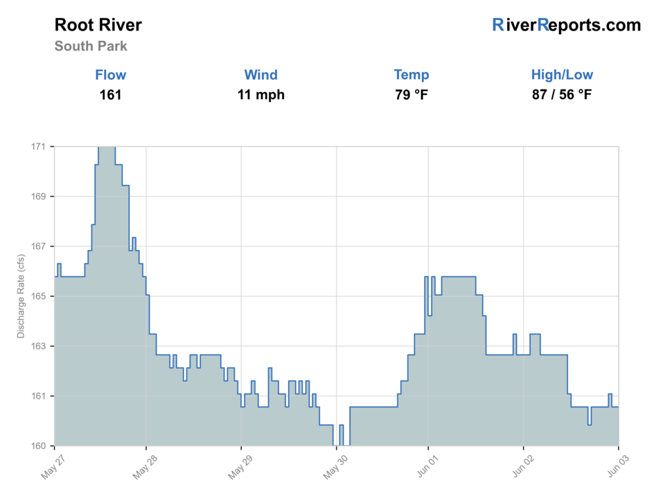
USGS data chart
Official USGS trend
Streamflow over the latest USGS reporting window.
Latest
161 cfs
Jun 3, 4 PM UTC
Weather
River weather report
Weather can change wading safety, road access, water temperature, hatches, and the best time of day to fish.
Live forecast loads as you reach this section
This keeps the report fast while still using the official National Weather Service forecast point.
Hatches and flies
Hatch chart and fly picks
March to April
Midges, early black stones, BWOs, scuds, and small olives
Zebra midge, scud, black stonefly, BWO emerger, pheasant tail
May to June
Caddis, sulphurs, March Browns, crane flies, light mayflies
Elk hair caddis, caddis pupa, sulphur, March Brown, crane fly larva
July to September
Terrestrials, tricos, small olives, hoppers, beetles, ants
Foam ant, beetle, small hopper, trico spinner, dry-dropper
Fall and winter
BWOs, midges, scuds, small streamers in stained water
BWO, zebra midge, scud, pink squirrel, small leech
Nymphs
Pheasant tail, hare's ear, caddis pupa, zebra midge, stonefly
Use when trout are not rising or when broken water hides subsurface feeding.
Dry flies
BWO, Hendrickson, sulphur, caddis, parachute Adams, terrestrial
Use during visible hatches, spinner falls, or quiet bank feeders.
Streamers
Sculpin, leech, woolly bugger, small baitfish
Use in stained water, higher flows, low light, or deeper cover.
Soft hackles
Partridge and orange, pheasant tail soft hackle, caddis soft hackle
Swing through riffles and tailouts when insects are moving but rises are hard to read.
Tactics
How to fish it
Use the Minnesota trout map before parking; easement boundaries are part of the fishing plan.
Approach pools low and slow because clear Driftless trout spook quickly.
Fish scuds and small nymphs through spring-influenced runs when no hatch is visible.
After rain, try a small dark streamer only if clarity and footing are still safe.
Use terrestrials along grass banks in summer and let the fly drift tight to cover.
Rigging
Rod, leader, and setup notes
A 3-weight or 4-weight rod is ideal for most small-stream work.
Carry 9-foot leaders with 5X to 6X for clear water.
Use short dry-dropper rigs in pocket water and lighter indicators in deeper pools.
Bring small scuds, midges, pheasant tails, caddis, ants, beetles, and a few streamers.
Studded boots help on muddy banks and slick limestone, but move quietly.
Access
Access and planning notes
Houston trend check
Downstream flow proxyWade / float / trail
Gauge / trout reach decision
When to pick it
Start here when basin flow and recent rain decide whether the South Fork is worth checking.
Caution
The gauge is downstream context, not an exact upper-reach answer.
DNR trout maps and easements
Legal access planningWade / float / trail
Easement / road crossing / wade
When to pick it
Use it before choosing any Driftless reach.
Caution
Stay inside mapped easements and respect fences, pasture, and private land.
Lanesboro stream conditions
Clarity and rain checkWade / float / trail
Condition report / local scout
When to pick it
Pick it when recent storms or valley stain could change the plan.
Caution
A good map does not make muddy or warm water fishable.
Minnesota trout easements are specific. Stay within mapped access and respect private land.
Rainfall can make roads, banks, and crossings poor quickly in Driftless valleys.
Special regulation reaches differ. Confirm the named water and reach before choosing flies, harvest, or bait.
Regulations
Check before fishing
Minnesota trout rules, special regulation reaches, and easement boundaries control the fishing plan. Check the regulation PDF and DNR trout maps before fishing.
Primary base
Preston, Lanesboro, or Houston
Best day style
Small-stream wading, easements, road crossings, and Driftless valley access
Check first
MN trout maps, Lanesboro stream conditions, Houston flow proxy, and rainfall
Safety
Fast rain response, muddy banks, private land, sinkholes, and cold spring water
Gear
Helpful gear for this water
4-weight or 5-weight rod
Best for trout dries, nymphs, and light streamers.
6-weight rod
Useful for streamers, wind, bigger water, and mixed trout or bass reaches.
Thermometer
Check before handling trout in warm, low, or late-summer water.
Studded boots
Helpful on slick cobble, limestone, tailwater ledges, and shaded rocks.
Nearby water
Other water to research
Backup logic
High water
Move to another mapped Driftless creek or wait for stain and bank mud to settle.
Heat
Fish early only if water temperatures are safe; stop trout pressure when low water warms.
Storms or stain
Use Lanesboro conditions and rainfall before driving to a specific easement.
Access issue
Use mapped public easements only; pivot to South Branch Root, Whitewater, or St. Croix if access is unclear.
South Branch Root River
A nearby Root-system trout page with similar rain and easement planning.
Whitewater River
Another southeastern Minnesota trout option with quick storm response.
St. Croix River
A warmwater scenic-river option when trout streams are muddy or warm.
FAQ
Fast answers
Is Root River, South Fork fishable today?
Root River, South Fork looks very fishable right now. The live score is 91/100, based on current flow, weather, public alerts, and the report's planning context. Recheck the linked gauge and forecast before leaving because conditions can change quickly after rain, heat, access changes, or flow swings.
What flow is best for Root River, South Fork?
Use RiverReports and USGS 05385500 near Houston as downstream trend context, then compare Lanesboro stream conditions and recent rainfall before judging upper reaches.
When should I skip Root River, South Fork?
Skip or choose a safer creek when storms have stained the valley, banks are muddy, temperature is high, or the mapped easement and rule section are not clear.
Is Root River, South Fork safe to wade right now?
The fishability score is not a wading guarantee. Wade only where your chosen access has safe edges, clear footing, legal entry, and no forced crossings; high, rising, stained, or storm-affected water should be treated conservatively.
What should I check first before fishing the South Fork Root River?
Check the Houston flow proxy, Lanesboro stream conditions, Minnesota trout map, rainfall, and exact special-rule reach.
Are there special regulations on the South Fork Root River?
Yes. Some Root system reaches have special trout rules, and easement boundaries matter.
Is the South Fork Root River a good fly-fishing river?
Yes, if you match the reach, season, target species, water temperature, and current access rules. This report is built to help you choose that plan.
What flies should I bring for the South Fork Root River?
Bring the hatch-chart flies, confidence nymphs, and a backup streamer or warmwater box so you can adjust to flow, clarity, and temperature.
How should I plan access for the South Fork Root River?
Use DNR trout maps, easements, road crossings, and legal public areas. Do not wander across private pasture or yards.
Sources
Source set for this report
Reviewed 2026-05-31