
Massachusetts / Northeast
Deerfield River
A Deerfield planning page built around the upper Charlemont tailwater, Fife Brook release awareness, public wading access, and technical trout timing.
Image: Generated regional planning image for Deerfield River / BlueStreamFly generated; not exact location / BlueStreamFlyFishability now: Deerfield River fishability today
GreatData confidence: High96/100
Fishable now because Charlemont gauge is stable, weather is usable, and no public alert is active.
Flow observed
4:30 PM UTC
Weather observed
5:00 PM UTC
Score calculated
5:24 PM UTC
Why this rating
Flow
Weather
Public alerts
Next 6-12 hours
Hold
Stable live data supports staying with the plan, but recheck the gauge and forecast before leaving.
USGS flow
211 cfs
Current trend: flow stable, so weather, temperature, and access checks drive the next change.
More planning details: flies, flow bands, and live source checks
Fish it today
Start here
Check the chart at breakfast, pick one River Road stop or the dam access based on release shape, then reassess by midday instead of assuming the whole river will hold steady.
Best flow clue
Stable or gently changing release windows that leave obvious seam edges, safe pockets, and enough margin to wade without chasing the middle.
Skip trigger
Skip when the river is climbing under you, the whitewater crowd is taking over the reach you wanted to fish, or footing feels marginal before you even start.
Flow decision bands
Stable trout release
Stable Charlemont flow and a release shape with defined seams is the best signal for upper Deerfield wading.
Sudden generation rise
Rising Fife Brook releases should move anglers off mid-river wades and into bank-only or no-go logic.
Lower clear window
Lower clear water can fish technically with longer leaders, smaller bugs, and careful spacing.
Whitewater or summer traffic
Boat, raft, and tubing traffic can make a fishable flow a weaker trout choice during popular release windows.
USGS flow
211 cfs
Current trend: flow stable, so weather, temperature, and access checks drive the next change.
Live USGS flow
211 cfs / stable
Live NWS forecast
79F / Sunny
Water temperature not verified
Heat guidance uses weather and river type unless an official water-temperature value is available.
No NWS alert flag
No active NWS alert was returned for this forecast point.
RiverReports is the working chart, backed by USGS 01168500 at Charlemont for official flow context.
MassWildlife's Deerfield catch-and-release guidance says the upper section runs from Fife Brook Dam downstream to the Hoosac Tunnel railroad bridge.
MassWildlife notes excellent wading access from River Road plus cartop access at Fife Brook Dam.
Great River Hydro and MassWildlife both warn that Fife Brook releases can change the river quickly, so release timing matters as much as the headline flow number.
Editorial review
How this report is maintained
This report uses official regulation, flow, weather, access, and public-land sources first, then adds practical planning guidance for fly anglers.
Byline
BlueStreamFly editorial desk
Reviewed by
BlueStreamFly source review
Maintained by
BlueStreamFly
Last material review
2026-06-02
Report confidence
High confidence
91/100
High confidence: RiverReports, USGS 01168500 at Charlemont, Massachusetts freshwater regulations, MassWildlife catch-and-release guidance, Deerfield upper map, wild brown trout context, Great River Hydro recreation guidance, weather coverage, generated media disclosure, and route-specific release guidance support the page. Confidence is moderated by generation timing, river traffic, pull-off crowding, exact boundary awareness, and wade-versus-boat choices.
Regulations
Massachusetts freshwater and MassWildlife catch-and-release sources support current upper Deerfield special-regulation checks.
Access
MassWildlife upper Deerfield map and Great River Hydro recreation sources support Fife Brook, River Road, and Hoosac Tunnel planning.
Flow and weather
RiverReports, USGS 01168500 at Charlemont, and the National Weather Service point support live flow and weather decisions.
Fishing usefulness
The page now separates release timing, upper catch-and-release boundaries, River Road access, summer traffic, safe wading, lower clear windows, and Massachusetts backup waters.
Fishability dashboard and source review
2026-06-02 / material content or source review
RiverReports and USGS 01168500 Charlemont flow, Massachusetts freshwater regulations, MassWildlife catch-and-release guidance, MassWildlife Deerfield upper map, wild brown trout context, Great River Hydro recreation guidance, National Weather Service data, and route-specific Fife Brook release guidance were checked before updating the current-fishability decision layer.
2026-06-02
Updated the upper Deerfield River to the current fishability standard with release-aware trend bands, access cards, backup cues, stable fishability SEO, and confidence signals.
2026-05-26
Published a new upper Deerfield report with Fife Brook release framing, River Road access guidance, Charlemont flow context, and original trout-planning detail.
Angler planning edge
Local details that change the plan
Best for
Technical wade days, Caddis and sulphur timing, Spring through fall trout sessions near Charlemont
Wade or float
Mostly wade. Boats matter on this river, but the upper Charlemont plan is strongest when you pick one or two wading stops and fish them around generation timing.
Best flows
Stable or gently changing release windows that leave obvious seam edges, safe pockets, and enough margin to wade without chasing the middle.
When to skip
Skip when the river is climbing under you, the whitewater crowd is taking over the reach you wanted to fish, or footing feels marginal before you even start.
Local plan
Check the chart at breakfast, pick one River Road stop or the dam access based on release shape, then reassess by midday instead of assuming the whole river will hold steady.
Pressure
Pressure concentrates at the easiest pull-offs and on well-known hatch windows. The smarter move is often timing and discipline, not trying to outwalk every other angler.
Access nuance
Access is good for a New England major river, but parking is still finite and the best-looking stop may already be occupied. Have a second stop ready.
Backup water
If generation or crowding ruins the upper Deerfield plan, the lower Deerfield, Westfield, or Millers can be better uses of the rest of the day.
About the river
Setting, character, and why it fishes the way it does.
The upper Deerfield is a boulder-heavy Massachusetts tailwater where cold releases from Fife Brook Dam keep trout habitat viable well into the warm season.
Its best fishing water is technical without being tiny: broad seams, riffles, slots, and bank-side structure all matter, but the river still reacts quickly to release changes.
This page is focused on the Charlemont and Fife Brook side of the river, where River Road access and the upper catch-and-release reach make the trout plan more direct than it is farther downstream.
Target species
Brown trout
The main technical-trout draw, with MassWildlife reporting a strong wild component in the upper Deerfield.
Rainbow trout
Still part of the upper-river trout mix and spring stocking picture.
Brook trout
Present in the system and nearby tributary coldwater context, though less common than brown trout in the main upper tailwater.
Reading the water
Stable generation
The best all-around window for nymphs, caddis, and dry-dropper fishing through broad riffles and seam edges.
Sudden release increase
Back off mid-river wades and treat the day as a bank-only or no-go call if the river starts climbing.
Lower clear window
Lengthen leaders, fish small dries and emergers, and avoid over-covering obvious community runs.
Summer crowding
Plan around boat traffic, tubers, and other anglers instead of assuming every good run will stay quiet.
Best seasons
Spring
Strong for stocked fish, caddis and mayfly windows, and cooler all-day conditions.
Early summer
Often the best mix of hatches and cold-release stability before crowding peaks.
Summer
Still viable because of cold dam releases, but whitewater traffic and timing matter more.
Fall
Good for streamer and nymph days when flows are predictable and nights cool again.
Preferred flow source
Deerfield River at Charlemont
RiverReports is the preferred chart source when coverage exists. When a matching USGS gauge exists, keep it open as the official backstop for station data and current hydrograph context.
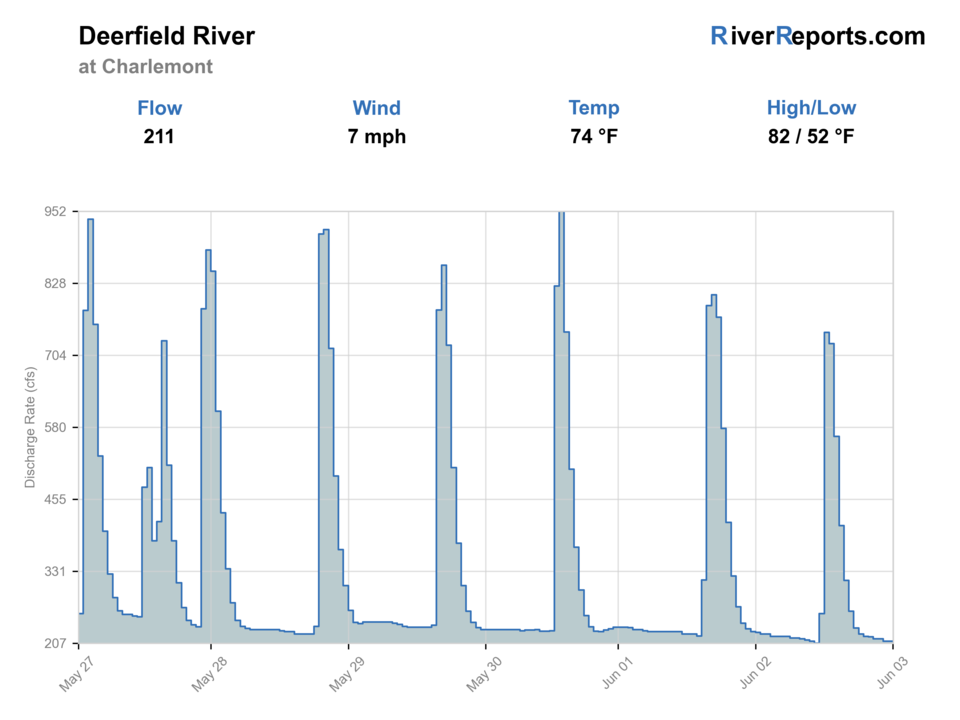
USGS data chart
Official USGS trend
Streamflow over the latest USGS reporting window.
Latest
211 cfs
Jun 3, 4 PM UTC
Weather
River weather report
Weather can change wading safety, road access, water temperature, hatches, and the best time of day to fish.
Live forecast loads as you reach this section
This keeps the report fast while still using the official National Weather Service forecast point.
Hatches and flies
Hatch chart and fly picks
Early spring
Midges and BWOs
RS2, zebra midge, parachute BWO
Late spring
Caddis, March Browns, sulphurs
Elk hair caddis, March Brown soft hackle, sulphur emerger
Summer
Caddis, sulphurs, ants and beetles
X-caddis, sulphur cripple, foam ant, beetle
Fall
BWOs and caddis
BWO comparadun, caddis pupa, small streamer
Match-the-hatch dries
Elk hair caddis, sulphur dry, parachute BWO, ant
You have steady surface activity or enough soft water to fish upstream cleanly.
Upper-river nymphs
Pheasant tail, hare's ear, caddis pupa, zebra midge
Current is steady and fish are set up in riffle seams or tailouts.
Streamers
Small sculpin, olive bugger, slim articulated trout streamer
Cloud cover, shoulder seasons, or slightly elevated release windows keep fish off the surface.
Tactics
How to fish it
Check the release picture before you leave because a safe early-morning wade can be a very different river later in the day.
Fish the first seam and bank edge well instead of racing through every River Road pull-off.
Treat the upper Deerfield as a technical community fishery where timing and spacing often beat hero casts.
When boat traffic or release push takes away your wade plan, either move to the bankiest water or switch rivers instead of forcing crossings.
Rigging
Rod, leader, and setup notes
A 4- or 5-weight floating-line setup covers most dry, emerger, and nymph work here.
Carry 4X through 6X because the river swings from bouldery push to flat technical edges.
One dry-dropper rig and one indicator or euro-style nymph setup usually cover the useful range.
A wading staff is a real advantage when generation changes or the rocks get slick.
Access
Access and planning notes
Fife Brook Dam access
Upper release anchorWade / float / trail
Cartop / boat / wade context
When to pick it
Start here when release timing and flow shape support the upper catch-and-release plan.
Caution
Release changes can quickly change bank, boat, and wade safety.
River Road pull-offs
Primary wading corridorWade / float / trail
Roadside / walk-wade
When to pick it
Use them when stable flows leave readable riffles, slots, and bank seams.
Caution
Pull-offs are limited and the best etiquette is to fish one stop thoroughly.
Hoosac Tunnel bridge reach
Lower special-reach referenceWade / float / trail
Catch-and-release boundary context
When to pick it
Pick it when you need the downstream end of the upper special-regulation reach in mind.
Caution
Boundary awareness matters before moving between access points.
River Road creates excellent access by Deerfield standards, but pull-offs are limited and the best etiquette is to fish one stop thoroughly instead of leapfrogging every parked car.
This is a multi-user river. Expect rafts, kayaks, and tubers during popular release windows and summer weekends.
Fife Brook releases can rise quickly enough to change both footing and drift lanes in the middle of a session.
Regulations
Check before fishing
Use current Massachusetts freshwater regulations and the Deerfield catch-and-release map before fishing. The upper special-regulation reach is artificial lures only and all fish must be released.
Primary base
Charlemont, Shelburne Falls, or North Adams
Best day style
Roadside pull-offs, named dam access, and boat or wade days shaped by release timing
Check first
RiverReports trend, USGS 01168500, Massachusetts regulations, release timing, and weather
Safety
Generation changes, slick boulders, cold water, river traffic, and steep bank entries
Gear
Helpful gear for this water
4- or 5-weight rod
The best all-around upper Deerfield tool for dries, nymphs, and small streamers.
Wading staff
Useful insurance when footing shifts with release changes.
Layers for dam-cold water
The upper river can fish colder than the air suggests.
Compact caddis and sulphur box
A simple hatch-focused box usually beats carrying too much.
Nearby water
Other water to research
Backup logic
Heavy release
Fish bank-only water, wait for the release to settle, or choose Westfield or Millers instead.
Crowded summer corridor
Shift to low-light hours, a quieter pull-off, or a different Massachusetts trout river.
Low technical water
Lengthen leaders, fish smaller bugs, and avoid overworking community runs.
Rule or boundary uncertainty
Check the MassWildlife maps and current regulations before fishing the special reach.
Deerfield River at West Deerfield
The lower Deerfield option when you want the broader downstream corridor.
Millers River
A central Massachusetts backup with different trout and warmwater reach choices.
Westfield River
Another Massachusetts major-river plan when you want freestone water instead of a release-shaped tailwater.
FAQ
Fast answers
Is Deerfield River fishable today?
Deerfield River looks very fishable right now. The live score is 96/100, based on current flow, weather, public alerts, and the report's planning context. Recheck the linked gauge and forecast before leaving because conditions can change quickly after rain, heat, access changes, or flow swings.
What flow is best for Deerfield River?
Stable or gently changing release windows that leave obvious seam edges, safe pockets, and enough margin to wade without chasing the middle.
When should I skip Deerfield River?
Skip when the river is climbing under you, the whitewater crowd is taking over the reach you wanted to fish, or footing feels marginal before you even start.
Is Deerfield River safe to wade right now?
The fishability score is not a wading guarantee. Wade only where your chosen access has safe edges, clear footing, legal entry, and no forced crossings; high, rising, stained, or storm-affected water should be treated conservatively.
What should I check first on the upper Deerfield?
Start with RiverReports and USGS 01168500 at Charlemont, then confirm the current Massachusetts catch-and-release rules and the day's release timing.
Is the upper Deerfield mostly a wade river?
It is a strong wade river from River Road, but it also sees boat traffic and release schedules that can change what is safe.
Why can this river fish well in summer?
MassWildlife notes that cold releases from Fife Brook Dam help the upper section support trout year round.
Sources
Source set for this report
Reviewed 2026-06-02