
Idaho / West
South Fork Clearwater River
A Highway 14 corridor planning page for anglers deciding whether the South Fork Clearwater has the right mix of legal opportunity, Stites flow shape, and public access for a worthwhile day.
Image: Generated regional planning image for South Fork Clearwater River / BlueStreamFly generated; not exact location / BlueStreamFlyFishability now: South Fork Clearwater River fishability today
GreatData confidence: High96/100
Fishable now because Stites gauge is falling, weather is mild, and no public alert is active.
Flow observed
3:15 PM UTC
Weather observed
4:00 PM UTC
Score calculated
4:20 PM UTC
Why this rating
Flow
Weather
Public alerts
Next 6-12 hours
Improving / hold
A falling gauge and usable weather should keep the next 6-12 hours in play unless tributaries stain or heat builds.
USGS flow
738 cfs
Current trend: flow falling, rating likely holding strong unless weather or clarity changes.
More planning details: flies, flow bands, and live source checks
Fish it today
Start here
Start at one named Highway 14 site, fish the first reliable edge water well, and move only if the gauge and clarity say the rest of the corridor is worth it.
Best flow clue
Stable clear-to-lightly tinted flows that still leave readable travel seams and soft banks at the Stites corridor.
Skip trigger
Skip when the river is muddy, the species season is not clearly open for your target, or the corridor turns into pure runoff management instead of fishing water.
Flow decision bands
Stable clear corridor flow
Stable or slowly falling Stites flow is the best sign that banks, soft seams, and named Highway 14 access points can fish cleanly.
Runoff color or rise
Rising or muddy water should turn the day into scouting or a skip unless protected edges still have visibility.
Low clear resident-fish water
Low summer flow can fish early with compact nymphs, soft hackles, and shade-aware movement.
Species-rule mismatch
The river can look fishable while salmon or steelhead targeting is not legally open for the plan in your head.
USGS flow
738 cfs
Current trend: flow falling, rating likely holding strong unless weather or clarity changes.
Live USGS flow
738 cfs / falling about 13%
Live NWS forecast
62F / Partly Sunny
Water temperature not verified
Heat guidance uses weather and river type unless an official water-temperature value is available.
No NWS alert flag
No active NWS alert was returned for this forecast point.
RiverReports is the working chart, backed by USGS 13338500 at Stites for official flow context.
Idaho Fish and Game lists the South Fork Clearwater as a recommended fishing water with cutthroat catch-and-release rules and separate salmon and steelhead season pages.
Nez Perce-Clearwater National Forest keeps the Highway 14 corridor, South Fork Campground, and Johns Creek access corridor in the official public-access stack.
This page is strongest as a corridor planning tool for timing, legality, and access discipline rather than as a hatch-only trout page.
Editorial review
How this report is maintained
This report uses official regulation, flow, weather, access, and public-land sources first, then adds practical planning guidance for fly anglers.
Byline
BlueStreamFly editorial desk
Reviewed by
BlueStreamFly source review
Maintained by
BlueStreamFly
Last material review
2026-06-02
Report confidence
Good confidence
88/100
Good confidence: RiverReports, USGS 13338500 at Stites, Idaho Fish and Game South Fork Clearwater rules, Idaho steelhead and salmon sources, Nez Perce-Clearwater Highway 14 access pages, weather coverage, generated media disclosure, and route-specific corridor guidance support the page. Confidence is moderated by species-season complexity, runoff color, corridor access conditions, heat, and exact target choice.
Regulations
Idaho Fish and Game sources support resident-fish, cutthroat, salmon, and steelhead rule checks, with anadromous species requiring live season confirmation.
Access
Nez Perce-Clearwater National Forest sources support Highway 14, South Fork Campground, and Johns Creek access planning.
Flow and weather
RiverReports, USGS 13338500 at Stites, and the National Weather Service point support live flow and weather decisions.
Fishing usefulness
The page now separates corridor flow, Highway 14 access, runoff color, species-specific rules, resident-fish tactics, heat stops, and Clearwater-area backups.
Fishability dashboard and source review
2026-06-02 / material content or source review
RiverReports and USGS 13338500 Stites flow, Idaho Fish and Game South Fork Clearwater rules, Idaho steelhead and salmon rule context, Nez Perce-Clearwater National Forest Highway 14 access, National Weather Service data, and route-specific corridor guidance were checked before updating the current-fishability decision layer.
2026-06-02
Updated the South Fork Clearwater River with Highway 14 flow bands, Forest Service access cards, backup cues, and confidence signals.
2026-05-26
Published a new South Fork Clearwater River report with Stites gauge context, corridor-specific access anchors, and separate-species rule guidance.
Angler planning edge
Local details that change the plan
Best for
Corridor planning days, Resident-fish sessions with honest gauge checks, Anglers willing to separate trout plans from seasonal steelhead or salmon plans
Wade or float
Mostly wade and bank-oriented from named corridor access, with more value in repeated short stops than in forcing a broad float-first plan.
Best flows
Stable clear-to-lightly tinted flows that still leave readable travel seams and soft banks at the Stites corridor.
When to skip
Skip when the river is muddy, the species season is not clearly open for your target, or the corridor turns into pure runoff management instead of fishing water.
Local plan
Start at one named Highway 14 site, fish the first reliable edge water well, and move only if the gauge and clarity say the rest of the corridor is worth it.
Pressure
Pressure concentrates around the easiest corridor access and during active salmon or steelhead windows, so quiet resident-fish sessions often fish best outside the obvious peaks.
Access nuance
The corridor is easy to overestimate. Public access is real, but legality and usefulness still improve when you stick to named sites instead of every roadside opening.
Backup water
If the South Fork is too broad, colored, or rule-complicated for the day, pivot to the main-stem Clearwater or a colder mountain alternative like the Lochsa after checking conditions.
About the river
Setting, character, and why it fishes the way it does.
The South Fork Clearwater is a long Idaho corridor river with a mix of resident trout, whitefish, steelhead, salmon, and seasonal opportunity that changes character with flow and species focus.
The Highway 14 alignment makes access more straightforward than many canyon rivers, but that convenience can tempt anglers into fishing it without checking the specific live rules that apply to anadromous species.
The best plan is to decide up front whether you are making a resident-fish trip, an in-season steelhead or salmon trip, or simply scouting a future window.
Target species
Rainbow trout
Part of the resident-fish mix and a realistic target when corridor flows are stable and clear enough.
Cutthroat trout
Managed under catch-and-release rules on this water and worth handling like the conservation priority they are.
Mountain whitefish
A dependable sign that you are fishing the right depth and current speed when trout are quiet.
Steelhead
Seasonal opportunity only under separate Idaho steelhead openings and rules.
Chinook salmon
Seasonal opportunity only when Idaho Fish and Game posts an active opener for the relevant South Fork reach.
Reading the water
Stable moderate flow
Best for swinging soft edges, nymphing travel seams, and fishing named corridor access without guessing.
High or dirty water
Usually a skip or scout call because the corridor loses clarity and safe bank positions quickly.
Low clear summer flow
Fish early, keep drifts compact, and focus on cover and shade instead of forcing bright open runs.
Cold shoulder-season flow
A good resident-fish and whitefish window if the river still has shape and you are not relying on a stale salmonid opener.
Best seasons
Spring
Useful only when current openings and runoff conditions line up cleanly.
Early summer
A transition window where gauge trend and species-specific rules matter more than generic seasonal assumptions.
Summer
Best for resident-fish corridor planning during cooler morning periods and clearer flow windows.
Fall
Strong when cooler weather improves corridor comfort and the river is not carrying too much color.
Preferred flow source
South Fork Clearwater River at Stites
RiverReports is the preferred chart source when coverage exists. When a matching USGS gauge exists, keep it open as the official backstop for station data and current hydrograph context.
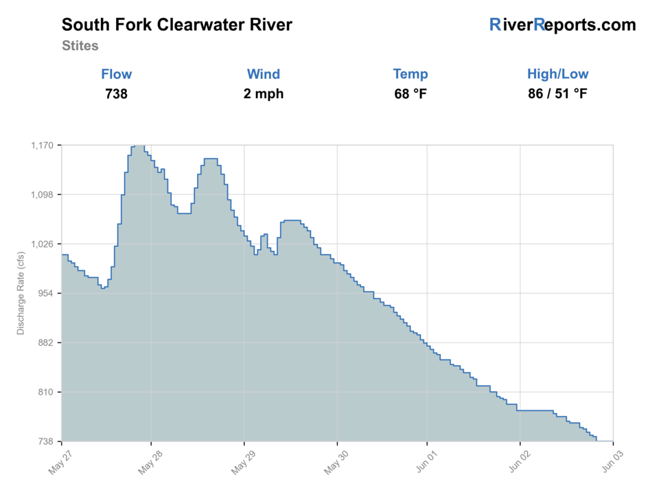
USGS data chart
Official USGS trend
Streamflow over the latest USGS reporting window.
Latest
738 cfs
Jun 3, 4 PM UTC
Weather
River weather report
Weather can change wading safety, road access, water temperature, hatches, and the best time of day to fish.
Live forecast loads as you reach this section
This keeps the report fast while still using the official National Weather Service forecast point.
Hatches and flies
Hatch chart and fly picks
Spring
Midges, caddis, and small mayflies
Zebra midge, caddis pupa, pheasant tail, soft hackle
Early summer
Caddis, PMDs, and stonefly nymph windows
Elk hair caddis, PMD emerger, stonefly nymph
Summer
Caddis and terrestrials
Foam ant, beetle, caddis dry, small hopper
Fall
BWOs, caddis, and streamer windows
Parachute BWO, caddis emerger, olive bugger
Resident-fish nymphs
Pheasant tail, hare's ear, caddis pupa, perdigon
You need to cover travel lanes and deeper edge slots cleanly.
Soft hackles
Partridge and orange, caddis soft hackle, sparse wet flies
Fish are sliding through softer seams during caddis or mixed emergence.
Dry-dropper
Stimulator, caddis dry, ant, compact tungsten dropper
Clearer summer corridor water lets you fish banks and pocket edges efficiently.
Tactics
How to fish it
Check the Stites gauge first, then decide whether the day is a resident-fish session, a live-season steelhead or salmon check, or a full skip.
Fish named corridor access points well instead of wasting time improvising questionable pull-offs.
Keep anadromous-species planning separate from trout planning because the rules, hooks, and season status are not interchangeable.
When runoff color removes edge definition, the better call is usually to wait rather than forcing the day.
Rigging
Rod, leader, and setup notes
A 5-weight floating-line setup covers most resident-fish jobs on the South Fork Clearwater corridor.
Carry 3X through 5X tippet so you can swing from soft-hackle and streamer edges to smaller nymphs without overcomplicating the day.
Keep one simple nymph rig and one dry-dropper rig ready rather than rebuilding at each roadside stop.
If you are targeting steelhead or salmon during an open season, re-rig specifically for those rules and hook restrictions before fishing.
Access
Access and planning notes
South Fork Campground
Primary corridor anchorWade / float / trail
Forest Service campground / bank
When to pick it
Start here when you want a named public access point with a clear flow and clarity check.
Caution
A good parking spot does not solve runoff color or species-rule uncertainty.
Johns Creek Trailhead
Walk-in scoutWade / float / trail
Trailhead / footbridge corridor
When to pick it
Use it when you want a more deliberate access check and room to compare edge water.
Caution
Corridor footing and weather can change quickly along a long mountain road.
Highway 14 pull-offs
Color and edge checkWade / float / trail
Roadside scout
When to pick it
Use them to compare visibility before committing to one named access.
Caution
Only fish pull-offs where parking and entry are clearly legal and safe.
The Highway 14 corridor makes this river easier to scout than many Idaho canyon waters, but named public sites are still the safest anchors.
Seasonal access decisions should factor in current Forest Service road and corridor conditions before you commit to a long upstream drive.
This is a better one-corridor day than a hop-between-every-spot day unless you are only scouting flows and access.
Regulations
Check before fishing
Use Idaho Fish and Game's South Fork Clearwater water page first, then check the current separate steelhead and salmon rules if those species are part of your plan. Cutthroat are catch-and-release only here, and special hook rules can apply while fishing for steelhead or salmon.
Primary base
Kooskia or Stites
Best day style
Roadside pull-off scouting, campground stops, and short walk-in river access along Highway 14
Check first
RiverReports trend, USGS 13338500, Idaho Fish and Game current species rules, and Highway 14 weather
Safety
Runoff color, slick banks, corridor traffic, long river miles between services, and current-season rule confusion
Gear
Helpful gear for this water
5-weight rod
A clean all-around resident-fish setup for nymphs, dries, and light streamers.
Wading staff
Useful when roadside entries look easy but the bank drops faster than expected.
Rain shell
The corridor is long enough that mountain weather changes can outlast a short stop.
Current rule screenshot or offline copy
Helpful when cell service thins out and species-specific rule checks still matter.
Nearby water
Other water to research
Backup logic
Muddy runoff
Wait for the Stites trend to settle or pivot to a clearer Idaho tributary plan.
Species-season uncertainty
Fish resident species only under confirmed rules or pause until IDFG season details are clear.
Hot bright corridor
Fish early, keep resident-fish handling quick, or move to colder mountain water.
Access confidence is low
Stay with named Forest Service sites instead of improvising roadside entries.
Clearwater River
The main-stem backup when you need larger-water context and a different access pattern.
Lochsa River
A colder, steeper alternative when you want freestone feel over broad corridor water.
Little Salmon River
A smaller-system pivot if the South Fork is too broad or too colored for the day.
FAQ
Fast answers
Is South Fork Clearwater River fishable today?
South Fork Clearwater River looks very fishable right now. The live score is 96/100, based on current flow, weather, public alerts, and the report's planning context. Recheck the linked gauge and forecast before leaving because conditions can change quickly after rain, heat, access changes, or flow swings.
What flow is best for South Fork Clearwater River?
Stable clear-to-lightly tinted flows that still leave readable travel seams and soft banks at the Stites corridor.
When should I skip South Fork Clearwater River?
Skip when the river is muddy, the species season is not clearly open for your target, or the corridor turns into pure runoff management instead of fishing water.
Is South Fork Clearwater River safe to wade right now?
The fishability score is not a wading guarantee. Wade only where your chosen access has safe edges, clear footing, legal entry, and no forced crossings; high, rising, stained, or storm-affected water should be treated conservatively.
What should I check first on the South Fork Clearwater River?
Start with RiverReports and USGS 13338500 at Stites, then confirm the current Idaho Fish and Game rules for the exact species you plan to target.
Can I fish this page as a generic trout report all year?
Not safely. Resident-fish planning is one thing, but salmon and steelhead seasons require separate live-rule checks and can change the legal picture.
Where should I start if I have never fished the corridor?
Use one named Highway 14 access point such as South Fork Campground or Johns Creek, fish it well, and let flow and clarity decide whether you expand the day.
Sources
Source set for this report
Reviewed 2026-06-02