
Idaho / West
Lochsa River
A Highway 12 corridor Lochsa River planning page built around a fast freestone canyon, roadside access discipline, and spring-through-fall cutthroat timing.
Image: Generated regional planning image for Lochsa River / BlueStreamFly generated; not exact location / BlueStreamFlyFishability now: Lochsa River fishability today
GreatData confidence: High96/100
Fishable now because the live gauge is falling, weather is mild, and no public alert is active.
Flow observed
5:00 PM UTC
Weather observed
5:00 PM UTC
Score calculated
5:24 PM UTC
Why this rating
Flow
Weather
Public alerts
Next 6-12 hours
Improving / hold
A falling gauge and usable weather should keep the next 6-12 hours in play unless tributaries stain or heat builds.
USGS flow
5,460 cfs
Current trend: flow falling, rating likely holding strong unless weather or clarity changes.
More planning details: flies, flow bands, and live source checks
Fish it today
Start here
Start near Lowell, fish one or two proven corridor stops well, then move only if the next access site offers a better angle or cleaner pocket structure.
Best flow clue
Stable summer and early-fall levels that leave obvious pockets, edge seams, and safe exit lines from the bank.
Skip trigger
Skip when runoff, cold push, or storm color turns every visible seam into a forceful crossing problem.
Flow decision bands
Runoff has settled
Stable or falling Lowell flow after runoff is the first sign that pocket water and bank exits may be workable.
Low clear cutthroat window
Clear lower summer flow is the best dry-fly and dry-dropper setup if wading stays close to shore.
High canyon push
Fast, cold, or rising canyon current should make the day scouting only.
Storm or road caution
Thunderstorms, slick rocks, and narrow Highway 12 pullouts can end the plan even when flow looks fishable.
USGS flow
5,460 cfs
Current trend: flow falling, rating likely holding strong unless weather or clarity changes.
Live USGS flow
5,460 cfs / falling about 21%
Live NWS forecast
69F / Partly Sunny
Water temperature not verified
Heat guidance uses weather and river type unless an official water-temperature value is available.
No NWS alert flag
No active NWS alert was returned for this forecast point.
Use RiverReports first for the public graph, then confirm the main corridor trend with USGS 13337000 near Lowell.
IDFG requires barbless hooks on the lower Highway 12 corridor and changes trout rules around the Memorial Day window.
Forest Service corridor access makes the river easy to reach, but the fast canyon current can make simple-looking banks a bad wading choice.
If the Lochsa is too high, too cold, or too pushy, the best move is often to wait or scout rather than force a dangerous freestone day.
Editorial review
How this report is maintained
This report uses official regulation, flow, weather, access, and public-land sources first, then adds practical planning guidance for fly anglers.
Byline
BlueStreamFly editorial desk
Reviewed by
BlueStreamFly source review
Maintained by
BlueStreamFly
Last material review
2026-06-02
Report confidence
High confidence
90/100
High confidence: RiverReports, USGS 13337000 Lowell flow, Idaho Fish and Game Lochsa rules, Forest Service Highway 12 corridor and White Pine access sources, weather coverage, generated media disclosure, and route-specific Lochsa guidance support the page. Confidence is moderated by runoff timing, fast canyon current, road pullout safety, storms, and seasonal rule changes.
Regulations
Idaho Fish and Game Lochsa River sources support barbless, seasonal, and trout-rule checks.
Access
Forest Service Highway 12 corridor and White Pine access sources provide strong public planning anchors, with individual pullout safety still needing field checks.
Flow and weather
RiverReports, USGS 13337000 near Lowell, and the National Weather Service point support live flow and weather decisions.
Fishing usefulness
The page now separates runoff recession, Highway 12 access, barbless-rule checks, safe bank exits, storm caution, and backup Idaho choices.
Fishability dashboard and source review
2026-06-02 / material content or source review
RiverReports and USGS 13337000 Lowell flow, Idaho Fish and Game Lochsa River rules, Nez Perce-Clearwater Highway 12 corridor and White Pine access sources, National Weather Service data, and route-specific canyon safety guidance were checked before updating the current-fishability decision layer.
2026-06-02
Updated Lochsa River to the current fishability standard with runoff-aware flow bands, Highway 12 access cards, backup cues, stable fishability SEO, and confidence signals.
2026-05-26
Published a new Lochsa River report with Highway 12 access framing, gauge-backed pocket-water planning, and safety guidance for roadside canyon wading.
Angler planning edge
Local details that change the plan
Best for
Summer cutthroat dry-fly days, Road-trip scouting along Highway 12, Short-session pocket-water fishing
Wade or float
Treat this page as wade-first. Even though the corridor serves floaters, most fly anglers will get more value from short controlled bank entries than from casual boat assumptions.
Best flows
Stable summer and early-fall levels that leave obvious pockets, edge seams, and safe exit lines from the bank.
When to skip
Skip when runoff, cold push, or storm color turns every visible seam into a forceful crossing problem.
Local plan
Start near Lowell, fish one or two proven corridor stops well, then move only if the next access site offers a better angle or cleaner pocket structure.
Pressure
The river spreads people out, but easy access points and prime summer weekends still concentrate anglers at obvious pullouts and campgrounds.
Access nuance
The real value of the Forest Service corridor is not just parking. It gives you named, legal, repeatable access points so you can avoid dangerous improvisation.
Backup water
If the Lochsa is too high or too fast, switch to a calmer Idaho option rather than forcing canyon current. This is a river where waiting is often the smartest tactic.
About the river
Setting, character, and why it fishes the way it does.
The Lochsa runs through a steep forested corridor along Highway 12 and is one of the easiest major Idaho freestones to scout from the road.
That same road access is why the river attracts both experienced anglers and first-time canyon-freestone visitors, which makes conservative section choice and pullout etiquette part of the day.
The lower corridor near Lowell is the most practical planning anchor for this page because it combines the public gauge, IDFG's named special-rule reach, and the most visible access pattern.
Target species
Westslope cutthroat trout
The signature trout target for classic dry-fly and dry-dropper days.
Rainbow trout
Present in the corridor and part of the mixed trout fishery on the main river.
Mountain whitefish
A common nymph and soft-hackle bycatch in deeper slots.
Chinook salmon and steelhead context
Part of the drainage, but trout-focused planning still depends on current seasonal rules and closures.
Reading the water
Low clear flow
Best for dry flies, dry-droppers, and careful pocket-water wading close to shore.
Stable medium flow
A strong searching-water window if you stay disciplined about bank entries and short drifts.
High push
Treat the river as a scouting stop only. Fast canyon water erases wading errors quickly.
Cold post-runoff water
Fish slower inside edges, sun-exposed slots, and softer pocket structure.
Best seasons
Late spring
Only once runoff drops enough to reveal fishable edges and safer bank entries.
Summer
Prime season for cutthroat dry-fly fishing, attractor patterns, and easy campground-based travel.
Early fall
A good time for cool mornings, lower flow, and less byway traffic.
Winter
Usually more of a weather and access check than a dependable trout destination.
Preferred flow source
Lochsa River near Lowell
RiverReports is the preferred chart source when coverage exists. When a matching USGS gauge exists, keep it open as the official backstop for station data and current hydrograph context.
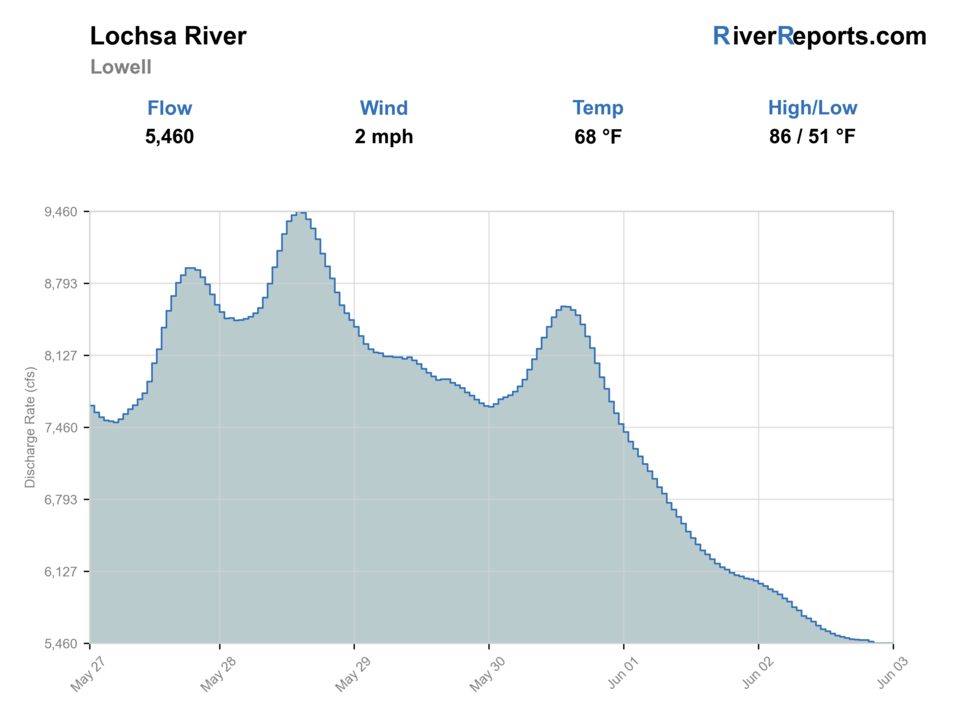
USGS data chart
Official USGS trend
Streamflow over the latest USGS reporting window.
Latest
5,460 cfs
Jun 3, 4 PM UTC
Weather
River weather report
Weather can change wading safety, road access, water temperature, hatches, and the best time of day to fish.
Live forecast loads as you reach this section
This keeps the report fast while still using the official National Weather Service forecast point.
Hatches and flies
Hatch chart and fly picks
Spring
March browns, BWOs, and caddis
Parachute Adams, BWO emerger, caddis pupa, prince nymph
Summer
Golden stones, caddis, PMDs, terrestrials
Stimulator, elk hair caddis, yellow sally, foam ant
Late summer
Terrestrials and evening caddis
Hopper-dropper, beetle, ant, soft hackle
Fall
BWOs, mahogany duns, midges
Parachute BWO, soft hackle, zebra midge
Attractor dries
Stimulator, chubby, elk hair caddis, parachute Adams
Best when the river is low enough for trout to rise along pocket seams and boulder edges.
Dry-dropper
Foam stone, hopper, ant with pheasant tail or prince
The easiest all-day searching system once flows settle.
Pocket-water nymphs
Prince, hare's ear, perdigon, soft hackle
Use in deeper slots or colder mornings before surface feeding gets obvious.
Small streamers
Bugger, sculpin, leech
Useful in shoulder seasons or when cloud cover lifts fish off structure.
Tactics
How to fish it
Fish only the water you can enter and exit cleanly from a legal pullout or access site.
Keep drifts short because the river's speed makes long-line mending mostly performative.
Use bigger dries to cover pocket water quickly, then add a dropper only when the river allows a clean drift.
If the river feels too pushy to wade, believe that feeling and step back to bank scouting.
Rigging
Rod, leader, and setup notes
A 9-foot 4- or 5-weight covers most Lochsa dry-fly and dry-dropper days.
Carry 4X and 5X because the fish are opportunistic but the current can expose weak knots fast.
Use sticky rubber or studs where legal; slick rock and cold current are the real rigging problem here.
A short streamer leader is enough for cloudy days or deeper pocket probes.
Access
Access and planning notes
Wilderness Gateway bridge area
Rule-line and corridor startWade / float / trail
Forest corridor / wade scout
When to pick it
Use it when lower-corridor rules, flow, and access timing all support a short focused session.
Caution
Barbless and seasonal rule checks still come before fishing.
Knife Edge Campground and River Access
Named public accessWade / float / trail
Forest Service / bank / wade
When to pick it
Start here when you want a repeatable access point instead of guessing from a highway shoulder.
Caution
Fast water can still make nearby banks unfishable.
White Pine River Access
Upper corridor scoutWade / float / trail
Forest Service / river access
When to pick it
Pick it when lower access is busy or the river needs a different pocket-water look.
Caution
Access convenience does not guarantee safe entries during runoff.
Highway 12 makes the Lochsa easy to overestimate; many visible banks still lead to fast water with poor wading margins.
Forest Service corridor pullouts and access sites are the safest way to structure the day instead of improvising random shoulder stops.
Campgrounds and river accesses fill quickly during rafting and summer-travel peaks, so start early if you want a flexible plan.
Regulations
Check before fishing
IDFG lists the lower Lochsa reach from the mouth upstream to the Wilderness Gateway Campground motor bridge with barbless-hook rules and changing trout restrictions before and after Memorial Day weekend. Check the current 2025-2027 rules before fishing.
Primary base
Lowell, Powell, or a Highway 12 campground
Best day style
Roadside pull-ins, campgrounds, river-access sites, and short canyon wade sessions
Check first
RiverReports, USGS 13337000, IDFG lower-Lochsa rules, access pullouts, and storms
Safety
Fast canyon current, cold water, slick rock, narrow shoulders, and early-summer runoff
Gear
Helpful gear for this water
Dry-dropper box
The most practical one-box system once flows settle.
Traction-focused wading kit
More important than extra fly boxes on this river.
Rain shell
The corridor can flip from pleasant to cold quickly in storms.
Roadside organization kit
Keep pullout transitions fast so you do not turn highway access into a mess.
Nearby water
Other water to research
Backup logic
High runoff
Wait for Lowell to fall or compare a smaller Idaho trout route instead of forcing canyon water.
Storms or cold push
Fish only protected edges or leave the corridor before exits become slick.
Traffic or access pressure
Move to another named Forest Service access rather than using unsafe shoulders.
Warm low water
Fish early, keep handling short, or switch to a colder Idaho option.
South Fork Boise drainage
A very different Idaho freestone-scale backup with less canyon-road intensity.
Big Wood River
A smaller valley river option when the Lochsa is too powerful for the kind of day you want.
Silver Creek Preserve
A spring-creek contrast when you want precision instead of pocket-water speed.
FAQ
Fast answers
Is Lochsa River fishable today?
Lochsa River looks very fishable right now. The live score is 96/100, based on current flow, weather, public alerts, and the report's planning context. Recheck the linked gauge and forecast before leaving because conditions can change quickly after rain, heat, access changes, or flow swings.
What flow is best for Lochsa River?
Stable summer and early-fall levels that leave obvious pockets, edge seams, and safe exit lines from the bank.
When should I skip Lochsa River?
Skip when runoff, cold push, or storm color turns every visible seam into a forceful crossing problem.
Is Lochsa River safe to wade right now?
The fishability score is not a wading guarantee. Wade only where your chosen access has safe edges, clear footing, legal entry, and no forced crossings; high, rising, stained, or storm-affected water should be treated conservatively.
Is the Lochsa easy because it runs beside the road?
No. It is easy to scout, but the current is still powerful and often wades much harder than it looks from Highway 12.
What gauge should I use?
Start with RiverReports and USGS 13337000 near Lowell for the main corridor trend.
When should I skip the Lochsa?
Skip it when runoff, cold push, or storm color make safe entries and short controlled drifts unrealistic.
Sources
Source set for this report
Reviewed 2026-06-02