
Idaho / West
Salmon River at Salmon
A focused upper Salmon River report for the Salmon-to-North Fork corridor, built around flow checks, public access, trout tactics, and clear anadromous-fish guardrails.
Image: Generated regional planning image for Salmon River at Salmon / BlueStreamFly generated; not exact location / BlueStreamFlyFishability now: Salmon River at Salmon fishability today
GreatData confidence: High96/100
Fishable now because Salmon gauge is stable, weather is mild, and no public alert is active.
Flow observed
4:00 PM UTC
Weather observed
4:00 PM UTC
Score calculated
4:20 PM UTC
Why this rating
Flow
Weather
Public alerts
Next 6-12 hours
Hold
Stable live data supports staying with the plan, but recheck the gauge and forecast before leaving.
USGS flow
3,690 cfs
Current trend: flow stable, so weather, temperature, and access checks drive the next change.
More planning details: flies, flow bands, and live source checks
Fish it today
Start here
Base in Salmon, check the gauge, pick a signed public access or BLM corridor plan, and fish the softest useful water first.
Best flow clue
Stable, clearing flows that keep bank seams readable and side water fishable without making wading unsafe.
Skip trigger
Skip when runoff is too high, visibility is poor, or warm water makes trout handling questionable.
Flow decision bands
Stable upper-river edge flow
Stable or slowly falling Salmon flow is the best sign that bank seams, side water, and boat-supported access can fish cleanly.
High runoff water
High or rising flow should push the plan away from casual wading and toward bank scouting, boat-only judgment, or a smaller backup.
Low clear warm valley water
Low clear flow can fish early, but heat and trout handling matter more than forcing midday coverage.
Anadromous rule check
The river can be fishable for resident trout while salmon or steelhead targeting still requires separate live IDFG confirmation.
USGS flow
3,690 cfs
Current trend: flow stable, so weather, temperature, and access checks drive the next change.
Live USGS flow
3,690 cfs / stable
Live NWS forecast
63F / Sunny
Water temperature not verified
Heat guidance uses weather and river type unless an official water-temperature value is available.
No NWS alert flag
No active NWS alert was returned for this forecast point.
RiverReports is the quick chart for this page, backed by USGS 13302500 Salmon River at Salmon ID.
Idaho Fish and Game's fishing planner identifies the Salmon River waterbody and should be checked for current rules before fishing.
BLM's Upper Salmon River material gives the strongest public-access and minimum-impact planning context around the Salmon and North Fork corridor.
Do not assume trout rules cover salmon, steelhead, or sturgeon. Check IDFG seasons and species rules before targeting migratory fish.
Editorial review
How this report is maintained
This report uses official regulation, flow, weather, access, and public-land sources first, then adds practical planning guidance for fly anglers.
Byline
BlueStreamFly editorial desk
Reviewed by
BlueStreamFly source review
Maintained by
BlueStreamFly
Last material review
2026-06-02
Report confidence
Good confidence
88/100
Good confidence: RiverReports, USGS 13302500 at Salmon, Idaho Fish and Game Salmon River rules, BLM Upper Salmon access guidance, weather coverage, generated media disclosure, and route-specific upper Salmon big-water guidance support the page. Confidence is moderated by runoff volatility, heat, anadromous-species rules, boat-versus-bank assumptions, and private-land access risk.
Regulations
Idaho Fish and Game Salmon River sources support resident-fish checks, with salmon and steelhead targeting needing separate current-season confirmation.
Access
BLM Upper Salmon River sources support signed public access and minimum-impact planning, while individual pullouts and private boundaries remain trip-specific.
Flow and weather
RiverReports, USGS 13302500 at Salmon, and the National Weather Service point support live flow and weather decisions.
Fishing usefulness
The page now separates Salmon gauge logic, BLM access, big-water edge safety, runoff skips, open-valley heat, anadromous rule checks, and nearby Idaho backups.
Fishability dashboard and source review
2026-06-02 / material content or source review
RiverReports and USGS 13302500 Salmon flow, Idaho Fish and Game Salmon River rules, BLM Upper Salmon River access guidance, National Weather Service data, and route-specific upper Salmon big-water guidance were checked before updating the current-fishability decision layer.
2026-06-02
Updated the Salmon River at Salmon with upper-river flow bands, BLM access cards, backup cues, and confidence signals.
2026-05-26
Published a new upper Salmon River report with flow-backed planning, BLM access guidance, trout tactics, and clear salmon/steelhead rule guardrails.
Angler planning edge
Local details that change the plan
Best for
Upper Salmon trout days, Salmon-based road trips, Big-water bank and boat planning
Wade or float
Both can work, but the river is large enough that public-bank and boat-supported plans often beat long blind wades.
Best flows
Stable, clearing flows that keep bank seams readable and side water fishable without making wading unsafe.
When to skip
Skip when runoff is too high, visibility is poor, or warm water makes trout handling questionable.
Local plan
Base in Salmon, check the gauge, pick a signed public access or BLM corridor plan, and fish the softest useful water first.
Pressure
Pressure concentrates around obvious public ramps and town access, but the river has enough size to spread out disciplined anglers.
Access nuance
The road follows the river, but not every pullout is a legal or respectful fishing access.
Backup water
Move to the Little Salmon, Lochsa, or a cooler tributary-style option when the main river is too big or warm.
About the river
Setting, character, and why it fishes the way it does.
The Salmon River near Salmon is a large mountain-valley river, not a small technical spring creek. It asks anglers to read broad current, boat ramps, side channels, and long banks.
The town of Salmon makes the reach easy to base from, but the water itself still changes quickly with snowmelt, rain, irrigation influence, and seasonal fish movement.
This page is scoped to the upper corridor around Salmon and North Fork. It is different from the lower canyon and White Bird reach, which has its own flow and access plan.
Target species
Rainbow and cutthroat trout
The core fly-fishing targets in softer seams, banks, and clearer side-water.
Mountain whitefish
Common in deeper nymphing lanes and a useful sign that your presentation is reaching fish.
Steelhead and salmon
Seasonal anadromous fish require separate IDFG season, method, and harvest checks before targeting.
Reading the water
Stable moderate flow
Best for bank nymphing, dry-dropper fishing, and boat-supported access to soft seams.
High runoff
Often too powerful or dirty for efficient wading. Look for protected edges only if visibility and safety allow.
Low clear summer water
Fish early, lengthen leaders, and focus on oxygenated riffle edges and deeper banks.
Fall clarity
A good time for streamers and heavier nymphs when trout use banks and travel lanes more confidently.
Best seasons
Spring
Pre-runoff windows can fish, but the river can rise fast with snowmelt or rain.
Early summer
Best after runoff begins dropping and clarity returns to bank and seam water.
Late summer
Fish early and watch temperature, especially during hot open-valley weather.
Fall
A strong trout window with cooler weather and better streamer or nymph conditions.
Preferred flow source
Salmon River at Salmon
RiverReports is the preferred chart source when coverage exists. When a matching USGS gauge exists, keep it open as the official backstop for station data and current hydrograph context.
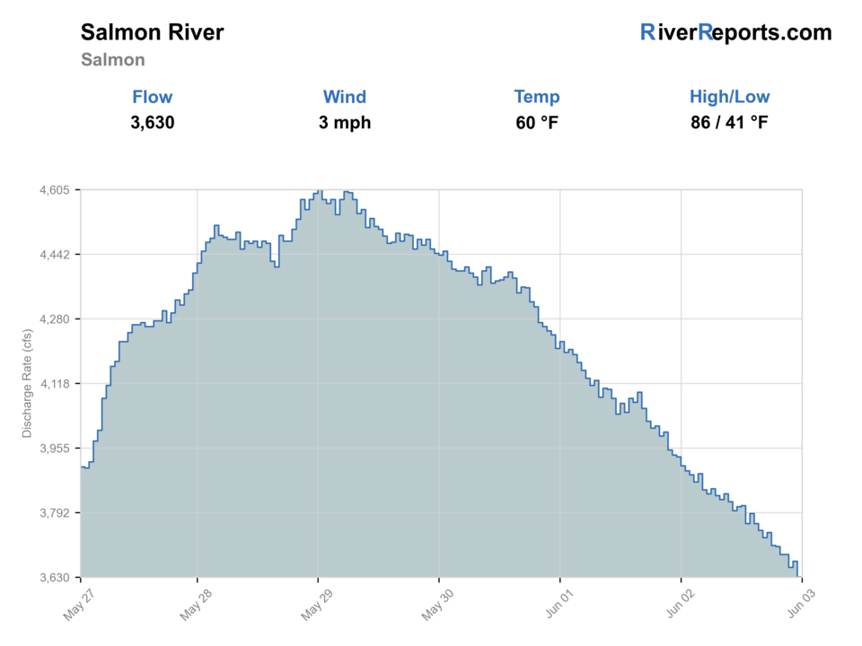
USGS data chart
Official USGS trend
Streamflow over the latest USGS reporting window.
Latest
3,690 cfs
Jun 3, 4 PM UTC
Weather
River weather report
Weather can change wading safety, road access, water temperature, hatches, and the best time of day to fish.
Live forecast loads as you reach this section
This keeps the report fast while still using the official National Weather Service forecast point.
Hatches and flies
Hatch chart and fly picks
Spring
Midges, BWOs, early caddis
Zebra midge, BWO emerger, caddis pupa
Early summer
Caddis, golden stones, PMDs
Elk hair caddis, pat's rubber legs, PMD cripple
Summer
Caddis, terrestrials, attractors
Hopper, ant, beetle, chubby-dropper
Fall
BWOs, midges, streamer windows
BWO emerger, zebra midge, olive bugger
Upper Salmon nymphs
Pat's rubber legs, pheasant tail, perdigon, caddis pupa
The river has depth and speed but enough clarity to work seams.
Bank dries
Chubby, hopper, elk hair caddis, foam ant
Summer banks and soft edges have active trout and safe temperatures.
Big-river streamers
Olive bugger, black leech, tan sculpin
Fall weather, stained edges, or low light give larger fish cover.
Tactics
How to fish it
Start by deciding whether the flow supports safe wading or whether the day is better handled from a boat or public bank.
Fish softer inside seams, side channels, and bank buckets before stepping into heavy current.
Use public boat ramps and signed access points. Do not improvise parking or bank entry on private ground.
Check IDFG rules before targeting steelhead or salmon; trout fishing and anadromous seasons are not the same thing.
Rigging
Rod, leader, and setup notes
A 5- or 6-weight rod is the best all-around tool for the upper Salmon's bigger water.
Use 3X through 5X for weighted nymphs and streamers, with lighter tippet only in clear dry-fly windows.
Carry enough split shot and buoyant dries to adjust quickly between deep banks and soft side water.
A thermometer, wading staff, and sun layer matter on long open-valley days.
Access
Access and planning notes
Salmon, Idaho area
Gauge and supplies baseWade / float / trail
Town access / bank / ramp context
When to pick it
Start here when you want the clearest link between the gauge, weather, and first public access decision.
Caution
Town convenience does not make big cold water easy to wade.
BLM Upper Salmon corridor
Primary access frameworkWade / float / trail
BLM access / ramps / bank
When to pick it
Use it when signed access and minimum-impact guidance line up with the day's flow.
Caution
Public-road proximity does not mean every gravel bar or pullout is legal access.
North Fork corridor
Downstream comparisonWade / float / trail
Roadside scout / longer plan
When to pick it
Pick it when you need more room, a different edge shape, or a boat-supported plan.
Caution
Runoff, heat, and species rules can change the day before the river changes visually.
The upper Salmon has real public access, but it is still a big river with private parcels, boat-ramp etiquette, and seasonal boating pressure.
Use signed access and BLM guidance rather than assuming every gravel bar or roadside pullout is public.
Spring runoff, cold water, and fast current make conservative wading decisions more important than covering extra water.
Regulations
Check before fishing
Check Idaho Fish and Game rules for the Salmon River before fishing, especially if salmon, steelhead, sturgeon, harvest, or special seasons could be involved.
Primary base
Salmon, Idaho
Best day style
Roadside walk-wade and planned boat access from signed public sites, with separate rules for salmon and steelhead seasons
Check first
RiverReports trend, USGS 13302500, IDFG fishing planner, BLM access guidance, and the Salmon forecast
Safety
Big cold water, spring runoff, boat traffic, private-land access mistakes, heat, and separate anadromous-fish rules
Gear
Helpful gear for this water
5- or 6-weight rod
Handles larger water, weighted nymphs, dry-droppers, and light streamers.
Wading staff
Useful around pushy banks and uneven cobble.
Thermometer
Important during warm open-valley afternoons.
Boat-ramp day kit
Useful if your plan involves shuttle timing, public launches, or long bank walks.
Nearby water
Other water to research
Backup logic
Runoff too big
Shift to Little Salmon, Lochsa, or another smaller Idaho option with clearer edge water.
Open-valley heat
Fish first light, carry a thermometer, and stop trout fishing before warm handling becomes the problem.
Species-rule uncertainty
Treat the day as resident-fish only or wait until IDFG salmon and steelhead rules are confirmed.
Access doubt
Stay with signed BLM or public access instead of improvising along private river frontage.
Salmon River at White Bird
A lower-canyon version of the Salmon with a different flow and access plan.
Little Salmon River
A smaller nearby system with a different access and flow profile.
Lochsa River
A wilder freestone alternative when you want a more forested Idaho plan.
FAQ
Fast answers
Is Salmon River at Salmon fishable today?
Salmon River at Salmon looks very fishable right now. The live score is 96/100, based on current flow, weather, public alerts, and the report's planning context. Recheck the linked gauge and forecast before leaving because conditions can change quickly after rain, heat, access changes, or flow swings.
What flow is best for Salmon River at Salmon?
Stable, clearing flows that keep bank seams readable and side water fishable without making wading unsafe.
When should I skip Salmon River at Salmon?
Skip when runoff is too high, visibility is poor, or warm water makes trout handling questionable.
Is Salmon River at Salmon safe to wade right now?
The fishability score is not a wading guarantee. Wade only where your chosen access has safe edges, clear footing, legal entry, and no forced crossings; high, rising, stained, or storm-affected water should be treated conservatively.
Is this the same as the Salmon River at White Bird page?
No. This page covers the upper Salmon near the town of Salmon. White Bird is a lower-river canyon reach with different flows and logistics.
What gauge should I check?
Use RiverReports for the quick chart and USGS 13302500 Salmon River at Salmon ID as the official flow reference.
Can I target salmon or steelhead here?
Only after checking current Idaho Fish and Game seasons, methods, and harvest rules. Those rules are separate from general trout planning.
Sources
Source set for this report
Reviewed 2026-06-02