
Colorado / West
Rio de Los Pinos
A borderland Rio de Los Pinos report for anglers checking Ortiz-area flows, high-country trail access, New Mexico campground context, and license boundaries.
Image: Generated regional planning image for Rio de Los Pinos / BlueStreamFly generated; not exact location / BlueStreamFlyFishability now: Rio de Los Pinos fishability today
GoodData confidence: High74/100
Fishable now because flow has been checked, weather is mild, and no public alert is active.
Flow observed
Not returned
Weather observed
5:00 PM UTC
Score calculated
5:26 PM UTC
Why this rating
Flow
Weather
Public alerts
Next 6-12 hours
Hold
Stable live data supports staying with the plan, but recheck the gauge and forecast before leaving.
USGS flow
Check gauge
Current trend: previous-score comparison will become more useful after repeated live checks.
More planning details: flies, flow bands, and live source checks
Fish it today
Start here
Use RiverReports for the trend, pick the Colorado trailhead or New Mexico campground access intentionally, then fish one short confirmed public section.
Best flow clue
Clear, stable flows after runoff and before late-summer warmth stresses fish.
Skip trigger
Skip when road access is uncertain, water is warm and low, or you cannot confirm the correct license/state rules.
Flow decision bands
Low but fishable
Low clear Rio de Los Pinos water can fish in small runs and banks when temperatures and the correct access rules line up.
Best borderland trout window
Stable or falling Ortiz flow with cool weather and known access is the best dry-dropper and light-nymph signal.
Runoff or road unsafe
Runoff, storm color, or poor road access should stop remote creek plans.
State-rule caution
Colorado and New Mexico access and license context must match the exact water you choose.
USGS flow
Check gauge
Current trend: previous-score comparison will become more useful after repeated live checks.
No current flow value
The source loaded, but did not return streamflow or gauge height.
Live NWS forecast
69F / Mostly Cloudy
Water temperature not verified
Heat guidance uses weather and river type unless an official water-temperature value is available.
No NWS alert flag
No active NWS alert was returned for this forecast point.
Use RiverReports for the Ortiz-area chart, then confirm whether your fishing spot is in Colorado or New Mexico.
Rio Grande National Forest's Los Pinos Trailhead gives upper Colorado access context.
Carson National Forest's Rio de Los Pinos Campground confirms downstream New Mexico public river access context.
Carry both regulation checks if your trip may cross the state line or use New Mexico access.
Editorial review
How this report is maintained
This report uses official regulation, flow, weather, access, and public-land sources first, then adds practical planning guidance for fly anglers.
Byline
BlueStreamFly editorial desk
Reviewed by
BlueStreamFly source review
Maintained by
BlueStreamFly
Last material review
2026-05-31
Report confidence
Good confidence
87/100
Good confidence: RiverReports Ortiz chart, USGS 08248000 flow, Rio Grande and Carson National Forest access sources, Colorado and New Mexico regulation sources, and weather data support the page. Confidence is moderated by state-line context, road access, lower-gauge representation, storms, and warm low water.
Regulations
Colorado and New Mexico regulation sources support the legal-check path, but the correct rule set depends on the exact reach.
Access
Rio Grande and Carson National Forest sources support access planning, with road status, state context, and posted boundaries still needing current confirmation.
Flow and weather
RiverReports, USGS 08248000, and the National Weather Service point are attached to the route.
Fishing usefulness
The page now separates Ortiz flow, Colorado versus New Mexico access, license context, roads, storms, heat, and backup choices.
Fishability dashboard and source review
2026-05-31 / material content or source review
RiverReports Rio de Los Pinos near Ortiz chart, USGS 08248000 flow data, Rio Grande National Forest Los Pinos Trailhead information, Carson National Forest Rio de Los Pinos Campground context, Colorado and New Mexico regulation sources, and the National Weather Service point were checked before updating the current fishability guidance.
2026-05-31
Updated Rio de Los Pinos with Ortiz trend guidance, Colorado trailhead and New Mexico campground access cards, state-rule, road, and warm-water cautions, backup cues, stable fishability SEO, and confidence signals.
2026-05-29
Added a page-specific report-confidence meter and added USGS Los Pinos River near Ortiz as official flow context for the cross-border Rio de Los Pinos report.
2026-05-25
Published a new Rio de Los Pinos report with Ortiz flow context, state-line regulation cautions, access planning, and hatch guidance.
Angler planning edge
Local details that change the plan
Best for
Borderland trout scouting, Small-stream dry-dropper fishing, Anglers willing to verify access first
Wade or float
Wade only. The default plan is walking confirmed public access, not floating.
Best flows
Clear, stable flows after runoff and before late-summer warmth stresses fish.
When to skip
Skip when road access is uncertain, water is warm and low, or you cannot confirm the correct license/state rules.
Local plan
Use RiverReports for the trend, pick the Colorado trailhead or New Mexico campground access intentionally, then fish one short confirmed public section.
Pressure
Pressure is lower than famous Colorado water, but the best obvious access can still see focused use.
Access nuance
This drainage crosses state and public-land contexts. Regulation and access checks are part of the fishing plan.
Backup water
Conejos River is the cleanest nearby Colorado backup when Rio de Los Pinos is uncertain.
About the river
Setting, character, and why it fishes the way it does.
Rio de Los Pinos flows out of southern Colorado toward northern New Mexico, with high-country forest access above and campground/wildlife-area context below.
This route is intentionally separate from the Los Pinos River/Pine River report in southwest Colorado. They are different trip plans and different drainages.
Because the river crosses jurisdiction and access types, the most helpful first question is not which fly to use; it is exactly where you are standing.
Target species
Brown trout
A common target in deeper bends, undercut banks, and lower-gradient meadow water.
Rainbow trout
Likely in mixed public trout water and faster runs.
Rio Grande cutthroat context
Native-trout habitat exists in the region; handle trout quickly and check special-water rules.
Reading the water
Clear stable flow
Best for dry-dropper rigs, short nymphs, and careful meadow approaches.
Low warm water
Fish early, use small flies, and quit before trout handling becomes stressful.
High runoff
Wait for safer edges and better visibility.
Borderline access
Stop and verify rules before fishing if you are near the state line or a posted boundary.
Best seasons
Late spring
Only after runoff drops enough for safe wading and clear presentations.
Summer
Primary dry-dropper season with caddis, PMDs, and terrestrials.
Early fall
Often the best mix of lower flows, cooler nights, and less traffic.
Winter
Limited by snow, ice, road conditions, and access.
Preferred flow source
Rio de Los Pinos near Ortiz
RiverReports is the preferred chart source when coverage exists. When a matching USGS gauge exists, keep it open as the official backstop for station data and current hydrograph context.
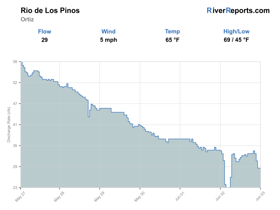
USGS data chart
Official USGS trend
Streamflow over the latest USGS reporting window.
Weather
River weather report
Weather can change wading safety, road access, water temperature, hatches, and the best time of day to fish.
Live forecast loads as you reach this section
This keeps the report fast while still using the official National Weather Service forecast point.
Hatches and flies
Hatch chart and fly picks
Spring
Midges, BWOs, small stones
Zebra midge, RS2, pheasant tail, small stonefly nymph
Summer
Caddis, PMDs, yellow sallies, terrestrials
Elk hair caddis, PMD, yellow stimulator, ant, beetle
Late summer
Hoppers, ants, beetles, caddis
Small hopper, foam beetle, caddis pupa, soft hackle
Fall
BWOs and midges
BWO emerger, zebra midge, olive soft hackle
Meadow dries
Parachute Adams, elk hair caddis, yellow stimulator, ant, beetle
Use in clear summer and fall water.
Droppers
Pheasant tail, hare's ear, perdigon, RS2
Use when fish hold below the film or under cutbanks.
Low-light streamers
Olive bugger, mini leech, small sculpin
Use in deeper bends or cloudy fall windows.
Tactics
How to fish it
Confirm your access and license state before rigging up.
Fish from downstream, keep a low profile, and work the inside edge before crossing.
Use a dry-dropper as the default and adjust depth one small step at a time.
Treat low warm water conservatively; fast releases matter more than photos.
Rigging
Rod, leader, and setup notes
A 3- or 4-weight covers the upper trail water; a 4- or 5-weight is useful on broader meadow sections.
Carry 5X and 6X for clear water, plus stronger tippet for hopper-dropper fishing.
Use compact leaders where willows or brush tighten the bank.
Bring a thermometer during warm periods and stop if water temperature becomes a trout-care issue.
Access
Access and planning notes
Los Pinos Trailhead
Colorado public access planWade / float / trail
Rio Grande NF / trail / wade
When to pick it
Start here when the plan is clearly on Colorado public-land access.
Caution
Road, trail, and posted access need current checks.
Rio de Los Pinos Campground
New Mexico-side contextWade / float / trail
Carson NF / campground / scout
When to pick it
Use it when intentionally comparing the New Mexico access side.
Caution
License and regulation context changes by state.
Ortiz gauge context
Flow and warmth checkWade / float / trail
Gauge / borderland decision
When to pick it
Pick it before deciding whether flow and weather support a small-stream trout day.
Caution
A gauge does not settle access or state-rule questions.
The Colorado and New Mexico sides can require different license and regulation checks.
Do not cross private or posted land to reach the river.
High-country roads and campground services can be seasonal; check before driving a long dirt-road loop.
Regulations
Check before fishing
Check Colorado rules for Colorado water and New Mexico rules if you fish downstream or use New Mexico access. Do not rely on one state license or rulebook for the whole drainage.
Primary base
Antonito, Colorado, or Tres Piedras, New Mexico
Best day style
High-country trail, campground, borderland, and boundary-aware wade planning
Check first
RiverReports, Colorado rules, New Mexico rules if crossing the line, Forest Service access, and weather
Safety
Remote roads, state-line confusion, low warm water, storms, private land, and limited services
Gear
Helpful gear for this water
3- to 5-weight rod
Choose lighter for upper trail water and stronger for broader meadow bends.
Thermometer
Useful in low warm late-summer water.
Printed or saved maps
Helpful where roads, trails, and state boundaries matter.
Dry-dropper box
Caddis, PMDs, small hoppers, and slim nymphs cover most windows.
Nearby water
Other water to research
Backup logic
High water
Compare the Conejos River or wait for runoff to drop.
Heat
Fish early, move higher, or stop trout pressure when low water warms.
Storms or road issues
Delay remote travel until road, lightning, and clarity improve.
Access issue
Confirm state, license, and public-land access first; choose Conejos if the exact reach is uncertain.
Conejos River
A nearby southern Colorado trout plan with more established corridor access.
Los Pinos River
A different southwest Colorado drainage; use it when you are planning around Bayfield/Ignacio.
Animas River
A larger San Juan Mountains option if you need more water and clearer town logistics.
FAQ
Fast answers
Is Rio de Los Pinos fishable today?
Rio de Los Pinos looks fishable right now. The live score is 74/100, based on current flow, weather, public alerts, and the report's planning context. Recheck the linked gauge and forecast before leaving because conditions can change quickly after rain, heat, access changes, or flow swings.
What flow is best for Rio de Los Pinos?
Clear, stable flows after runoff and before late-summer warmth stresses fish.
When should I skip Rio de Los Pinos?
Skip when road access is uncertain, water is warm and low, or you cannot confirm the correct license/state rules.
Is Rio de Los Pinos safe to wade right now?
The fishability score is not a wading guarantee. Wade only where your chosen access has safe edges, clear footing, legal entry, and no forced crossings; high, rising, stained, or storm-affected water should be treated conservatively.
Is Rio de Los Pinos the same as the Los Pinos River report?
No. This page is for the Ortiz and Colorado-New Mexico borderland drainage, not the Pine River/Los Pinos near Ignacio.
Do I need a New Mexico license?
You may if you fish or access water in New Mexico. Confirm your exact location before fishing.
What is the best first rig?
A small attractor dry with a slim nymph dropper is the best starting point in clear summer or fall water.
Sources
Source set for this report
Reviewed 2026-05-31