
Colorado / West
Los Pinos River
A practical Los Pinos report for San Juan mountain access, RiverReports flow support, official USGS context, private-water cautions, and trout tactics.
Image: Generated regional planning image for Los Pinos River / BlueStreamFly generated; not exact location / BlueStreamFlyFishability now: Los Pinos River fishability today
GreatData confidence: High96/100
Fishable now because the live gauge is stable, weather is mild, and no public alert is active.
Flow observed
4:45 PM UTC
Weather observed
5:00 PM UTC
Score calculated
5:25 PM UTC
Why this rating
Flow
Weather
Public alerts
Next 6-12 hours
Hold
Stable live data supports staying with the plan, but recheck the gauge and forecast before leaving.
USGS flow
151 cfs
Current trend: flow stable, so weather, temperature, and access checks drive the next change.
More planning details: flies, flow bands, and live source checks
Fish it today
Start here
Start with access boundaries, check flow and weather, fish one clearly legal reach, and keep the Animas as a backup.
Best flow clue
Stable post-runoff flows with clear banks, safe wading, and trout-safe water temperatures.
Skip trigger
Skip when access is unclear, the river is in heavy runoff, storms are building, or lower water is too warm for trout.
Flow decision bands
Low but fishable
Low clear Los Pinos water can fish in bends and riffles when temperatures and legal access are confirmed.
Best access-first trout window
Stable or falling flow with clear water and mild weather is useful only after the exact public or permitted reach is confirmed.
Runoff or storm unsafe
Runoff, muddy San Juan storm pulses, or unsafe crossings should stop wading.
Warm lower-water caution
Lower water can become a poor trout plan when heat and low flows stack up.
USGS flow
151 cfs
Current trend: flow stable, so weather, temperature, and access checks drive the next change.
Live USGS flow
149 cfs / stable
Live NWS forecast
68F / Mostly Sunny
Water temperature not verified
Heat guidance uses weather and river type unless an official water-temperature value is available.
No NWS alert flag
No active NWS alert was returned for this forecast point.
RiverReports gives the flow chart for this page, with USGS 09352800 as official backing near the lower river context.
San Juan National Forest lists river and stream fishing opportunities and Pine River Trail access in the district.
Private land and Southern Ute Reservation context matter on parts of the drainage, so do not assume a visible river is open to public fishing.
Fish early in summer, watch storms, and carry a thermometer where lower water warms.
Editorial review
How this report is maintained
This report uses official regulation, flow, weather, access, and public-land sources first, then adds practical planning guidance for fly anglers.
Byline
BlueStreamFly editorial desk
Reviewed by
BlueStreamFly source review
Maintained by
BlueStreamFly
Last material review
2026-05-31
Report confidence
Good confidence
86/100
Good confidence: RiverReports Los Pinos chart, USGS 09352800 flow, San Juan National Forest context, Southern Ute access information, Colorado regulation sources, and weather data support the page. Confidence is moderated by tribal and private boundaries, lower-gauge representation, storms, and warm low water.
Regulations
Colorado regulation sources support the legal-check path, with access permission still central for exact reach choice.
Access
Southern Ute and San Juan National Forest sources support access planning, but exact public or permitted reaches require current confirmation.
Flow and weather
RiverReports, USGS 09352800, and the National Weather Service point are attached to the route.
Fishing usefulness
The page now separates access boundaries, Ignacio flow trend, public-land context, runoff, warm-water restraint, and backup choices.
Fishability dashboard and source review
2026-05-31 / material content or source review
RiverReports Los Pinos River chart, USGS 09352800 flow data, San Juan National Forest fishing context, Southern Ute Los Pinos fishing access information, Colorado regulation sources, and the National Weather Service point were checked before updating the current fishability guidance.
2026-05-31
Updated Los Pinos River with Ignacio trend guidance, access-boundary cards, tribal and public-land cautions, runoff and warm-water backup cues, stable fishability SEO, and confidence signals.
2026-05-29
Added a page-specific report-confidence meter for Los Pinos flow, San Juan National Forest and Southern Ute access context, Colorado rule checks, weather, and access-first planning.
2026-05-25
Published a new Los Pinos River report with flow support, public-access cautions, hatch guidance, and San Juan mountain trip planning.
Angler planning edge
Local details that change the plan
Best for
San Juan mountain trout trips, Access-first planning, Summer dry-dropper fishing
Wade or float
Wade only for this report. The useful public plan is built around legal reach selection, not floating.
Best flows
Stable post-runoff flows with clear banks, safe wading, and trout-safe water temperatures.
When to skip
Skip when access is unclear, the river is in heavy runoff, storms are building, or lower water is too warm for trout.
Local plan
Start with access boundaries, check flow and weather, fish one clearly legal reach, and keep the Animas as a backup.
Pressure
Public access is more limited than on many Colorado rivers, so obvious legal reaches can feel busy.
Access nuance
Visible water can still be private or under tribal access rules. Verify before fishing.
Backup water
Animas River is the easiest nearby backup when access or flow makes the Los Pinos plan uncertain.
About the river
Setting, character, and why it fishes the way it does.
The Los Pinos, often called the Pine River locally, drains the San Juan Mountains before moving toward the lower valley and tribal and private-water context.
That mix makes the page different from a simple roadside trout report. The first useful question is where you can legally and practically access the river.
On public or legal access water, the fishing plan is classic mountain trout work: read banks and riffles, adapt to flow, and keep the rig simple until fish show you otherwise.
Target species
Brown trout
A primary target in deeper banks, runs, and lower-gradient trout water.
Rainbow trout
Present in public and managed reaches where habitat supports trout.
Cutthroat-influenced trout
Possible in the broader San Juan drainage; handle native or conservation-sensitive fish carefully.
Reading the water
Low clear water
Use smaller dries and nymphs, longer leaders, and careful approach angles.
Moderate stable flow
Best condition for dry-dropper rigs, caddis activity, and riffle-edge nymphing.
Runoff
Fish only protected edges if safe and legal, or wait for a clearer drop.
Warm lower water
Carry a thermometer and shift away from trout when temperatures are stressful.
Best seasons
Late spring
Runoff controls the river; watch flow and clarity before committing.
Summer
Primary public-trip season once high water settles and access roads are reliable.
Early fall
Often the best mix of stable water, cooler nights, and lower pressure.
Winter
Access, ice, and cold limit the public wade plan.
Preferred flow source
Los Pinos River
RiverReports is the preferred chart source when coverage exists. When a matching USGS gauge exists, keep it open as the official backstop for station data and current hydrograph context.
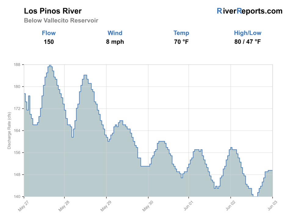
USGS data chart
Official USGS trend
Streamflow over the latest USGS reporting window.
Latest
149 cfs
Jun 3, 4 PM UTC
Weather
River weather report
Weather can change wading safety, road access, water temperature, hatches, and the best time of day to fish.
Live forecast loads as you reach this section
This keeps the report fast while still using the official National Weather Service forecast point.
Hatches and flies
Hatch chart and fly picks
Spring
Midges, BWOs, caddis, and stones
Zebra midge, BWO emerger, prince nymph, stonefly nymph
Summer
Caddis, PMDs, yellow sallies, ants, beetles, and hoppers
Elk hair caddis, PMD, yellow stimulator, ant, hopper
Late summer
Terrestrials and evening caddis
Hopper-dropper, beetle, caddis pupa, soft hackle
Fall
BWOs, midges, and streamer windows
RS2, zebra midge, olive bugger, small streamer
Mountain dries
Elk hair caddis, parachute Adams, PMD, ant, beetle
Use in lower clear water and visible surface activity.
Droppers and nymphs
Perdigon, pheasant tail, hare's ear, prince nymph
Best through riffles and deeper seams.
High-water patterns
Pats rubber legs, worm pattern where legal, olive bugger
Use on safe edges when the river is high but fishable.
Tactics
How to fish it
Confirm access first. If the reach is private or unclear, do not fish it just because the water looks good.
On public water, fish banks and riffle transitions before walking through them.
Use dry-dropper rigs once summer flows settle, and switch to nymphs if fish stay low.
Keep a backup in the broader San Juan drainage if storms, access, or flow shut down the first plan.
Rigging
Rod, leader, and setup notes
A 4- or 5-weight with floating line is the default.
Carry 3X to 6X tippet for streamers, droppers, and smaller dries.
A compact nymph rig helps in deeper runs, but avoid over-weighting shallow public water.
Bring a thermometer, rain shell, and map tools for access boundaries.
Access
Access and planning notes
Southern Ute access context
Boundary-first planningWade / float / trail
Access PDF / permission check / bank
When to pick it
Start here when the day depends on exact Los Pinos access permission.
Caution
Do not assume visible water is open without the current access and rule check.
San Juan National Forest context
Public-land planningWade / float / trail
Forest access / wade / scout
When to pick it
Use it when the route is tied to confirmed public land.
Caution
Forest context is broad and does not solve private or tribal boundaries by itself.
Ignacio gauge area
Flow and temperature checkWade / float / trail
Gauge / lower-river context
When to pick it
Pick it when flow trend and warmth will decide whether trout fishing is ethical.
Caution
Lower gauge context may not describe every upper access reach.
The public-access question is the main planning issue on this river.
Some lower-river opportunities are private, guided, or connected to tribal jurisdiction; do not rely on secondhand access assumptions.
Use official public-land and regulation sources before choosing a reach.
Regulations
Check before fishing
Check current Colorado fishing regulations and local access rules before fishing. Parts of the broader drainage involve private land or Southern Ute Reservation context, so public access should be verified before you step in.
Primary base
Bayfield, Vallecito, or Durango
Best day style
Public-land planning, trail access, private-water awareness, and short wades
Check first
RiverReports, USGS 09352800, San Juan National Forest access, Colorado rules, and weather
Safety
Private boundaries, tribal access context, runoff, storms, and warm lower water
Gear
Helpful gear for this water
4- or 5-weight rod
Flexible for dries, nymphs, and small streamers.
Thermometer
Useful on lower or warm-season trout water.
Map app or offline map
Important for public/private access decisions.
Rain shell
San Juan storms can build quickly.
Nearby water
Other water to research
Backup logic
High water
Compare the Animas River or wait for San Juan runoff to settle.
Heat
Fish early, move higher, or stop trout pressure in warm lower water.
Storms or stain
Delay until storm color and road access improve.
Access issue
Use only verified public or permitted access; pivot to the Animas if boundaries are uncertain.
Animas River
A larger nearby drainage with more town-based planning.
Dolores River
Another southwest Colorado option with its own access and flow checks.
Arkansas River
A bigger public-water option for a different trip plan.
FAQ
Fast answers
Is Los Pinos River fishable today?
Los Pinos River looks very fishable right now. The live score is 96/100, based on current flow, weather, public alerts, and the report's planning context. Recheck the linked gauge and forecast before leaving because conditions can change quickly after rain, heat, access changes, or flow swings.
What flow is best for Los Pinos River?
Stable post-runoff flows with clear banks, safe wading, and trout-safe water temperatures.
When should I skip Los Pinos River?
Skip when access is unclear, the river is in heavy runoff, storms are building, or lower water is too warm for trout.
Is Los Pinos River safe to wade right now?
The fishability score is not a wading guarantee. Wade only where your chosen access has safe edges, clear footing, legal entry, and no forced crossings; high, rising, stained, or storm-affected water should be treated conservatively.
Is the Los Pinos River all public?
No. Access is the first thing to verify because parts of the drainage involve private land or tribal context.
What flow source should I check?
Use RiverReports for the quick chart and USGS 09352800 for official backing.
What is the best fishing style?
Once flows settle, a dry-dropper or light nymph rig through banks, riffles, and soft seams is the practical starting point.
Sources
Source set for this report
Reviewed 2026-05-31