
Colorado / West
Conejos River
A practical Conejos River report for Mogote flow context, upper-river access, high-country hatches, and southern Colorado trip planning.
Image: Generated regional planning image for Conejos River / BlueStreamFly generated; not exact location / BlueStreamFlyFishability now: Conejos River fishability today
GoodData confidence: High74/100
Fishable now because flow has been checked, weather is mild, and no public alert is active.
Flow observed
Not returned
Weather observed
5:00 PM UTC
Score calculated
5:24 PM UTC
Why this rating
Flow
Weather
Public alerts
Next 6-12 hours
Hold
Stable live data supports staying with the plan, but recheck the gauge and forecast before leaving.
USGS flow
Check gauge
Current trend: previous-score comparison will become more useful after repeated live checks.
More planning details: flies, flow bands, and live source checks
Fish it today
Start here
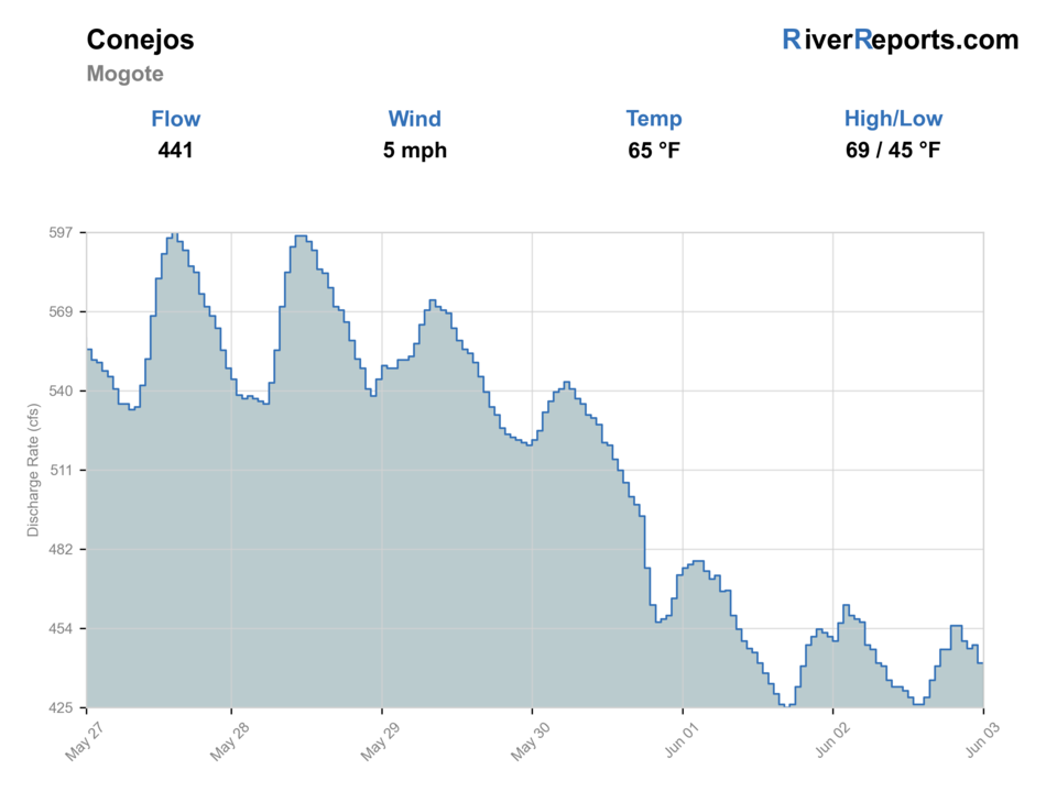
Start with the Mogote chart, choose lower roadside water for quick sessions or upper Forest Service access for a full-day plan, and keep a weather exit.
Best flow clue
Stable, clearing flows after runoff with enough water to connect riffles but not so much push that crossings drive the day.
Skip trigger
Skip during heavy runoff, muddy storm pulses, or when access roads and crossings become the main challenge.
Flow decision bands
Low but fishable
Low clear Conejos water can fish in riffles, bends, and shaded banks when temperatures and reach rules are safe.
Best high-country trout window
Stable or falling Mogote flow with clearing water and mild weather is the best dry-dropper and nymph signal.
Runoff or crossing unsafe
Heavy runoff, muddy storm pulses, or risky crossings should stop the wade plan.
Road and reach caution
Upper access roads, trail condition, and exact regulation reach matter before choosing a high-country plan.
USGS flow
Check gauge
Current trend: previous-score comparison will become more useful after repeated live checks.
No current flow value
The source loaded, but did not return streamflow or gauge height.
Live NWS forecast
67F / Mostly Sunny
Water temperature not verified
Heat guidance uses weather and river type unless an official water-temperature value is available.
No NWS alert flag
No active NWS alert was returned for this forecast point.
RiverReports gives the quickest working flow view for this page; the USGS Mogote page explains the official station context.
Upper access near the Conejos River Trail and North Fork Trail is more remote than the lower highway water.
Caddis, stones, PMDs, BWOs, and terrestrials can all matter, but flow and clarity decide the rig first.
Skip soft or dangerous crossings during runoff and watch summer storms in the San Juan high country.
Editorial review
How this report is maintained
This report uses official regulation, flow, weather, access, and public-land sources first, then adds practical planning guidance for fly anglers.
Byline
BlueStreamFly editorial desk
Reviewed by
BlueStreamFly source review
Maintained by
BlueStreamFly
Last material review
2026-05-31
Report confidence
Good confidence
87/100
Good confidence: RiverReports Mogote chart, USGS 08246500 flow, Forest Service Conejos trail sources, Colorado regulation sources, and weather data support the page. Confidence is moderated by upper-reach road status, trail crossings, storms, private edges, and broad reach scope.
Regulations
Colorado regulation sources support the legal-check path before choosing a Conejos reach.
Access
Forest Service Conejos and North Fork Conejos trail sources support upper access planning, while lower roadside boundaries still need confirmation.
Flow and weather
RiverReports, USGS 08246500, and the National Weather Service point are attached to the route.
Fishing usefulness
The page now separates lower Mogote checks, upper trail planning, runoff, storms, crossings, road access, and backup choices.
Fishability dashboard and source review
2026-05-31 / material content or source review
RiverReports Conejos River near Mogote chart, USGS 08246500 flow data, Rio Grande National Forest Conejos and North Fork Conejos trail information, Colorado regulation sources, and the National Weather Service point were checked before updating the current fishability guidance.
2026-05-31
Updated Conejos River with Mogote trend guidance, lower roadside and upper trail access cards, high-country storm and road cautions, backup cues, stable fishability SEO, and confidence signals.
2026-05-29
Added a page-specific report-confidence meter for Conejos River flow, Mogote gauge support, upper-river Forest Service access, Colorado regulation checks, weather, remote-travel planning, and generated regional imagery context.
2026-05-25
Published a new Conejos River report with Mogote flow context, upper-river access notes, hatch guidance, and high-country safety planning.
Angler planning edge
Local details that change the plan
Best for
Southern Colorado trout trips, Summer dry-dropper fishing, High-country access planning
Wade or float
Mostly wade fishing for this report. Some lower reaches are roadside, while upper reaches are walk-in or trail-based.
Best flows
Stable, clearing flows after runoff with enough water to connect riffles but not so much push that crossings drive the day.
When to skip
Skip during heavy runoff, muddy storm pulses, or when access roads and crossings become the main challenge.
Local plan
Start with the Mogote chart, choose lower roadside water for quick sessions or upper Forest Service access for a full-day plan, and keep a weather exit.
Pressure
Easier roadside water sees more pressure; upper access spreads anglers out but asks more from the trip plan.
Access nuance
Public and private boundaries matter. Confirm access before stepping into lower-valley water.
Backup water
The Animas or Arkansas can be better if the Conejos is still in runoff or storms are building over the San Juans.
About the river
Setting, character, and why it fishes the way it does.
The Conejos drains the south San Juan country and gives anglers a mix of meadow bends, forested pocket water, and more remote upper access.
Near Mogote and the Highway 17 corridor, the river is easier to check but can see more pressure. Upstream Forest Service access is quieter but requires more road and weather planning.
This is a river where the calendar matters less than snowmelt, clarity, and how much travel time you are willing to build into the day.
Target species
Brown trout
A key target in lower and middle river pools, cut banks, and riffle edges.
Rainbow trout
Present in public reaches and stocked or managed water.
Rio Grande cutthroat trout
A native-drainage species to treat carefully where present in upper tributary or restoration-influenced water.
Reading the water
Low clear water
Use longer leaders, smaller dries, and avoid heavy wading through likely holding water.
Moderate stable flow
Best condition for dry-dropper rigs, caddis, and nymphs in riffles and seams.
Runoff
Fish protected edges only if safe, or wait until the river drops and clears.
Summer storms
Expect fast changes in color and road comfort; keep a lower-risk backup.
Best seasons
Late spring
Watch runoff carefully. Some edge fishing is possible before the river is fully settled.
Summer
Prime high-country season for caddis, PMDs, stones, and terrestrial dry-dropper fishing.
Early fall
Often the cleanest mix of lower flows, cool nights, and better approach visibility.
Winter
Limited by ice, access, and cold; lower sections are more realistic than upper trail water.
Preferred flow source
Conejos River near Mogote
RiverReports is the preferred chart source when coverage exists. When a matching USGS gauge exists, keep it open as the official backstop for station data and current hydrograph context.
USGS data chart
Official USGS trend
Streamflow over the latest USGS reporting window.
Weather
River weather report
Weather can change wading safety, road access, water temperature, hatches, and the best time of day to fish.
Live forecast loads as you reach this section
This keeps the report fast while still using the official National Weather Service forecast point.
Hatches and flies
Hatch chart and fly picks
Spring
Midges, BWOs, caddis, and stoneflies
Zebra midge, BWO emerger, prince nymph, pats rubber legs
Summer
Caddis, PMDs, yellow sallies, and terrestrials
Elk hair caddis, PMD cripple, yellow stimulator, ant
Late summer
Hoppers, ants, beetles, and evening caddis
Hopper-dropper, foam ant, beetle, caddis pupa
Fall
BWOs and midges
Parachute BWO, RS2, zebra midge, small streamer
Dry-dropper
Stimulator, chubby, elk hair caddis, perdigon, pheasant tail
Primary summer search rig.
Runoff nymphs
Pats rubber legs, prince nymph, hare's ear, worm pattern where legal
Use in soft edges when the river is dropping but still heavy.
Clear-water dries
Parachute Adams, PMD, BWO, ant, beetle
Best in calmer glides and lower flows.
Tactics
How to fish it
Use the lower river for quick checks and the upper Forest Service corridor when you have enough time for road and weather planning.
In moderate flows, fish broken riffles, outside bends, and soft banks with a dry-dropper.
During lower clear water, slow down and fish from farther back before stepping into the channel.
If runoff is still heavy, pick protected bank water and stop before crossings become the main problem.
Rigging
Rod, leader, and setup notes
A 4- or 5-weight rod with floating line is the default.
Carry 3X to 6X tippet so you can switch from heavy nymphs to smaller dries.
A compact indicator rig helps in deeper runs, but dry-dropper covers a lot of summer water.
Bring layers and rain gear because upper Conejos weather can change quickly.
Access
Access and planning notes
Mogote / lower river
Gauge-area and roadside planWade / float / trail
Roadside / wade / bank
When to pick it
Start here when flow is stable and you want the clearest current-condition read.
Caution
Private edges and reach-specific rules still need current checks.
Conejos River Trail #712
Full-day upper accessWade / float / trail
Forest trail / wade
When to pick it
Use it when weather, trail conditions, and water level support a longer plan.
Caution
Storms, crossings, and remote exit time can become the main risk.
North Fork Conejos Trail #714
Tributary or high-country backupWade / float / trail
Trail / small water / scout
When to pick it
Pick it when the main river is pressured or you want colder higher water.
Caution
Do not assume identical rules, access, or flow to the mainstem.
Confirm public access before leaving the road corridor; private land exists along parts of the river.
Upper trail access is better for anglers prepared for distance, storms, and colder nights.
Avoid treating the whole river as one condition. Lower Mogote water and upper forest water can fish very differently.
Regulations
Check before fishing
Check the current Colorado fishing brochure before fishing, especially if you plan to move between lower public water, upper Forest Service access, and tributary reaches with different species concerns.
Primary base
Antonito, Mogote, or Alamosa
Best day style
Highway pullouts, Forest Service trailheads, campgrounds, and walk-in reaches
Check first
RiverReports, USGS 08246500 station context, Colorado rules, USFS access, and weather
Safety
Runoff, remote roads, storms, private property, and high-elevation exposure
Gear
Helpful gear for this water
4- or 5-weight rod
Flexible enough for dries, droppers, and moderate nymph rigs.
Rain shell
Important in the San Juan high country.
Wading staff
Helpful during higher water and uneven cobble.
Terrestrial box
Ants, beetles, and hoppers can matter in late summer.
Nearby water
Other water to research
Backup logic
High water
Compare the Arkansas or another settled drainage instead of forcing Conejos crossings.
Heat
Fish early, move higher, and stop trout pressure if water temperatures become stressful.
Storms or stain
Wait for San Juan thunderstorm color and road conditions to clear before committing.
Access issue
Use Forest Service trails or clearly legal roadside water; choose another route if boundaries or roads are uncertain.
Rio de Los Pinos
Another southern Colorado high-country option when access and flows line up.
Animas River
A larger southwest Colorado river with more town access.
Arkansas River
A broader freestone option when you want more public reach choices.
FAQ
Fast answers
Is Conejos River fishable today?
Conejos River looks fishable right now. The live score is 74/100, based on current flow, weather, public alerts, and the report's planning context. Recheck the linked gauge and forecast before leaving because conditions can change quickly after rain, heat, access changes, or flow swings.
What flow is best for Conejos River?
Stable, clearing flows after runoff with enough water to connect riffles but not so much push that crossings drive the day.
When should I skip Conejos River?
Skip during heavy runoff, muddy storm pulses, or when access roads and crossings become the main challenge.
Is Conejos River safe to wade right now?
The fishability score is not a wading guarantee. Wade only where your chosen access has safe edges, clear footing, legal entry, and no forced crossings; high, rising, stained, or storm-affected water should be treated conservatively.
What flow source should I check for the Conejos?
Use RiverReports for the quick chart and the USGS 08246500 Mogote page for station context, noting that current streamflow publishing has shifted to Colorado DWR.
Is the upper Conejos easy access?
No. Upper Forest Service access is more remote and needs road, weather, and hiking planning.
What is the best basic rig?
A buoyant dry with a small nymph dropper is the most flexible summer starting point.
Sources
Source set for this report
Reviewed 2026-05-31