
Colorado / West
Eagle River
A practical Eagle River report for the Avon, Edwards, Wolcott, and Gypsum corridor, with flow checks, access planning, hatches, and fly selection.
Image: South Fork Eagle River (Colorado) / CC BY 4.0 / Jeffrey BeallFishability now: Eagle River fishability today
GoodData confidence: High78/100
Fishable now because Avon gauge is rising, weather is mild, and no public alert is active.
Flow observed
3:30 PM UTC
Weather observed
4:00 PM UTC
Score calculated
4:20 PM UTC
Why this rating
Flow
Weather
Public alerts
Next 6-12 hours
Watch
Recheck within the next few hours; rising water or active weather can change clarity and wading quickly.
USGS flow
554 cfs
Current trend: flow rising, rating can drop quickly if clarity or wading safety deteriorates.
More planning details: flies, flow bands, and live source checks
Fish it today
Start here
Start with the Avon gauge and weather, then choose Avon/Edwards for a shorter wade check, Wolcott/Eagle for a broader valley plan, or Gypsum only when temperature and access still support trout handling.
Best flow clue
Use the Avon gauge trend more than one magic number. Stable or slowly falling clear flow is the best all-around trout signal; runoff, storm stain, or warm lower-river afternoons should move the plan upstream, earlier, or to another route.
Skip trigger
Skip or scale back when runoff is pushy, thunderstorms muddy the valley, lower-river temperatures are stressful, public access or private boundaries are unclear, or slick cobble makes crossings unsafe.
Flow decision bands
Low and clear
Use longer leaders, smaller mayfly or midge patterns, and careful bank approaches; avoid over-playing trout in warm lower water.
Best freestone window
Stable or slowly falling Avon flow with clear water gives the best mix of nymphs, caddis, dry-droppers, and streamer edges.
Runoff or storm stain
Fish only protected banks if safe, and avoid crossings when runoff or valley storms make cobble wading pushy.
Warm lower river
Hot afternoons below Wolcott, Eagle, or Gypsum can make trout handling the limiting factor even when access is open.
USGS flow
554 cfs
Current trend: flow rising, rating can drop quickly if clarity or wading safety deteriorates.
Live USGS flow
563 cfs / rising about 22%
Live NWS forecast
62F / Mostly Sunny
Water temperature not verified
Heat guidance uses weather and river type unless an official water-temperature value is available.
No NWS alert flag
No active NWS alert was returned for this forecast point.
RiverReports and USGS 09067020 give the best quick read for the Avon corridor.
Expect stronger currents and limited wading during spring runoff.
Public access improves around town parks, Eagle County open space, and BLM water downstream.
In hot weather, carry a thermometer and shift to early sessions or colder nearby water.
Editorial review
How this report is maintained
This report starts with official regulation, access, flow, weather, and public-river sources, then adds practical planning guidance for anglers.
Byline
BlueStreamFly editorial desk
Reviewed by
BlueStreamFly source review
Maintained by
BlueStreamFly
Last material review
2026-05-31
Report confidence
High confidence
86/100
Strong RiverReports plus USGS flow, Colorado Parks and Wildlife, Colorado regulation, and weather source coverage supports Eagle River fishability guidance. Confidence is capped by freestone runoff, storm pulses, lower-valley heat, and parcel-level access checks that still need same-day confirmation.
Regulations
Colorado special-regulation sources provide the current rule-check path.
Flow support
RiverReports coverage is backed by USGS 09067020 below the wastewater treatment plant at Avon.
Access support
CPW and route-source context support the corridor, but parcel-level public access still needs verification by reach.
Weather and safety
NWS support is paired with runoff, storm, warm-water, slick-cobble, and lower-valley heat cautions.
Angler usefulness
The page separates Avon gauge checks, reach choice, wade/float expectations, temperature risk, and backup-water decisions.
Editorial review
A public correction path, source standards page, latest verified note, and change log are included.
Fishability source review
2026-05-31 / material content or source review
RiverReports and USGS Avon flow support, Colorado Parks and Wildlife Eagle River material, Colorado special-regulation sources, and the National Weather Service Avon forecast point were rechecked before adding the current fishability decision layer.
2026-05-31
Upgraded the page to the Pine Creek fishability standard with a reviewed route profile, Vail Valley flow decision bands, access cards, backup logic, source-confidence meter, and a top-page current-fishability answer.
2026-05-24
Initial source-reviewed report published with flows, weather, hatches, flies, tactics, access, regulations, and FAQs.
Angler planning edge
Local details that change the plan
Best for
Vail Valley anglers choosing between Avon, Edwards, Wolcott, Eagle, and Gypsum based on same-day flow and heat, Freestone trout trips when the Avon gauge is stable, water is clear, and wading margins are safe, Nymph, dry-dropper, caddis, PMD, and streamer days that need a quick runoff or storm-pulse read, Anglers willing to move upstream, fish early, or switch rivers when lower-valley temperature or access weakens the plan
Wade or float
Treat the Eagle as a wade-first freestone page with selective float or lower-valley planning only when flow, temperature, and access support it.
Best flows
Use the Avon gauge trend more than one magic number. Stable or slowly falling clear flow is the best all-around trout signal; runoff, storm stain, or warm lower-river afternoons should move the plan upstream, earlier, or to another route.
When to skip
Skip or scale back when runoff is pushy, thunderstorms muddy the valley, lower-river temperatures are stressful, public access or private boundaries are unclear, or slick cobble makes crossings unsafe.
Local plan
Start with the Avon gauge and weather, then choose Avon/Edwards for a shorter wade check, Wolcott/Eagle for a broader valley plan, or Gypsum only when temperature and access still support trout handling.
Pressure
Easy town parks and obvious pullouts collect pressure once flows settle. Early starts, moving past the first bridge pool, and matching the reach to water temperature usually matter more than fly changes.
Access nuance
Public access is useful but not continuous. Town paths, open space, BLM water, road pullouts, and private frontage sit close together, so match the plan to a verified access point.
Backup water
If the Eagle is too high, warm, stained, or access-limited, compare the Fryingpan, Roaring Fork, or middle Colorado after checking each route's current flow and rules.
About the river
Setting, character, and why it fishes the way it does.
The Eagle River drains the central Colorado mountains and flows through the Vail Valley before joining the Colorado River near Dotsero.
For anglers, the useful plan usually follows the public pieces around Avon, Edwards, Wolcott, Eagle, and Gypsum rather than assuming continuous public bank access.
The river has a long mining and railroad history, but the modern fishing draw is a mix of wild trout, accessible town water, and lower-valley float or walk-in opportunities.
Because the Eagle is a freestone river, snowmelt, rain, clarity, and afternoon water temperature can change the day faster than on a steady tailwater.
Target species
Brown trout
A core Eagle River trout target, especially through lower valley structure, banks, and fall streamer water.
Rainbow trout
Common in productive valley reaches and often willing to eat nymphs, caddis, and mayflies when flows cooperate.
Cutthroat and cutbow trout
Possible in parts of the drainage, but do not plan around them in every reach without local confirmation.
Mountain whitefish
Present in Colorado River basin waters and a useful sign that deeper runs are holding fish.
Reading the water
Low and clear
Use longer leaders, lighter tippet, smaller mayfly or midge patterns, and careful bank approaches.
Stable medium flow
This is the most flexible window for nymphs, dry-droppers, caddis dries, and soft-hackle swings.
Runoff or stain
Fish inside bends, banks, and softer edges only if wading is safe. Streamers and larger stonefly nymphs become more useful.
Warm lower river
Check temperature. If trout handling risk is high, move upstream, fish early, or choose a colder option.
Best seasons
Winter
Slow nymphing can work near open water, but ice, snow access, and low metabolism limit the day.
Spring
Pre-runoff can be strong with midges, BWOs, and early caddis; runoff requires caution and edge fishing.
Summer
Caddis, PMDs, stones, and terrestrials matter, but lower-river temperatures should be checked.
Fall
Cooler weather, lower crowds, BWOs, and streamer windows can make this one of the best periods.
Preferred flow source
Eagle River below Wastewater Treatment Plant at Avon
RiverReports is the preferred chart source when coverage exists. When a matching USGS gauge exists, keep it open as the official backstop for station data and current hydrograph context.
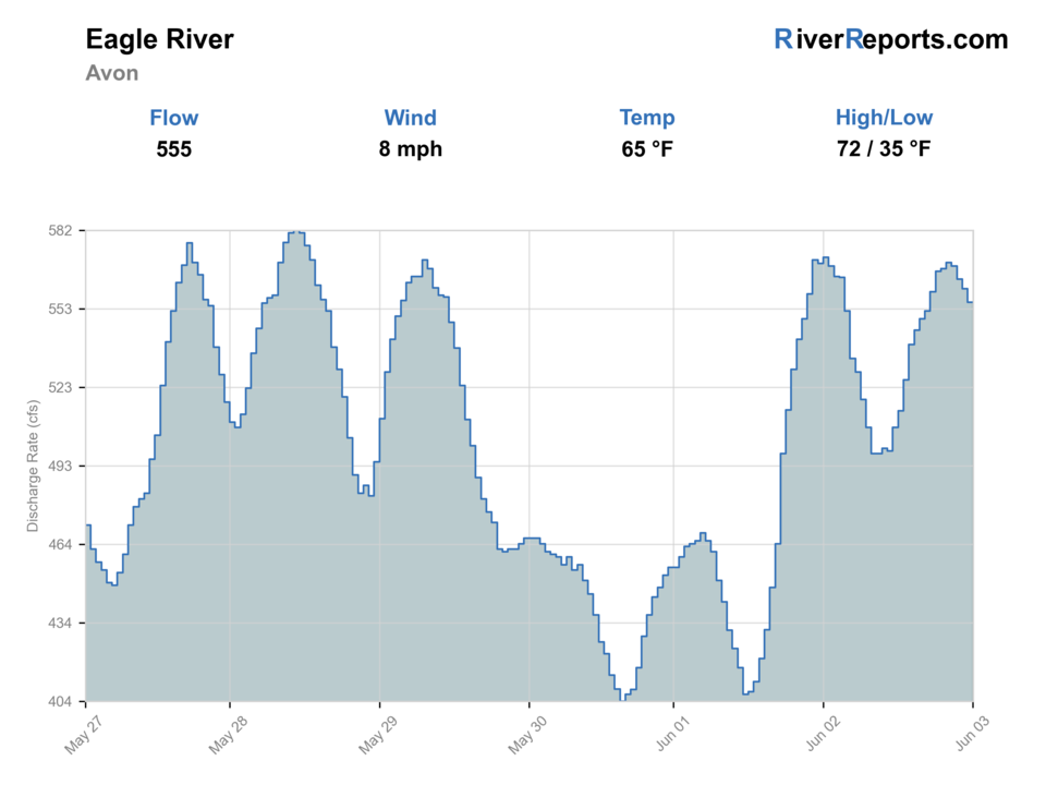
USGS data chart
Official USGS trend
Streamflow over the latest USGS reporting window.
Latest
554 cfs
Jun 3, 4 PM UTC
Weather
River weather report
Weather can change wading safety, road access, water temperature, hatches, and the best time of day to fish.
Live forecast loads as you reach this section
This keeps the report fast while still using the official National Weather Service forecast point.
Hatches and flies
Hatch chart and fly picks
Winter
Midges and small olives
Zebra midge, black beauty, RS2, small pheasant tail
Spring
BWOs, caddis, stoneflies
BWO emerger, elk hair caddis, Pat's rubber legs, hare's ear
Summer
Caddis, PMDs, yellow sallies, terrestrials
X-caddis, PMD cripple, yellow sally, ant, small hopper
Fall
BWOs, midges, October caddis
BWO dry, zebra midge, October caddis pupa, sculpin streamer
Nymphs
Pheasant tail, hare's ear, perdigon, caddis pupa, stonefly nymph
Use through riffles, buckets, and edge seams when fish are not clearly rising.
Dry flies
Elk hair caddis, PMD, parachute Adams, BWO, yellow sally
Use during visible hatch windows and soft summer evenings.
Dry-droppers
Chubby, stimulator, small hopper, tungsten pheasant tail
Use in pocket water and along bank structure during stable flows.
Streamers
Sculpin, sparkle minnow, woolly bugger, leech
Use after a bump in flow, during low light, or along deeper lower-river banks.
Tactics
How to fish it
Pick the reach after checking both flow and public access.
During runoff, fish soft edges instead of forcing mid-channel wading.
In clear summer water, lead fish with the first cast and reduce false casting.
Cover caddis water quickly, then slow down when you find rising fish.
Use a thermometer below Wolcott and Gypsum during hot afternoons.
Rigging
Rod, leader, and setup notes
A 9-foot 5-weight is the everyday Eagle River rod.
Use 4X to 6X for dries and smaller nymphs in clear water.
Carry heavier tippet and a 6-weight if streamer fishing lower-valley banks.
Bring split shot and indicators that adjust quickly as depth changes.
Use traction and a wading staff when the cobble is slick or flow is pushy.
Access
Access and planning notes
Avon gauge corridor
Primary flow and clarity checkWade / float / trail
Town access / walk-and-wade
When to pick it
Start here when you need a fast read on current speed, clarity, and wade margins before choosing a valley reach.
Caution
Town water gets pressure and slick cobble remains a wading risk during higher flow.
Edwards town water
Short wade sessionWade / float / trail
Path and park access
When to pick it
Use it when flow is stable and you want a manageable public-access trout plan.
Caution
Confirm posted boundaries and expect pressure during settled summer flows.
Wolcott to Eagle corridor
Broader valley planWade / float / trail
Open-space / road scout
When to pick it
Pick it when the gauge, clarity, and temperature support more water than a town-park check.
Caution
Public and private frontage changes quickly; verify each stop.
Gypsum and lower Eagle
Lower-valley optionWade / float / trail
Bank or selective float planning
When to pick it
Use it when water temperature, flow, and access are still clean enough for trout handling.
Caution
Heat and private property are bigger filters here than in upper valley water.
CPW notes that Eagle County and CPW have supported public access opportunities in the lower valley.
Do not cross or stop on private land unless a public access point clearly allows it.
Spring runoff can make otherwise familiar crossings unsafe.
Lower-river summer afternoons can become a trout-handling problem even when fishing is legal.
Regulations
Check before fishing
Check the current Colorado fishing regulations and any reach-specific special rules before fishing. Posted access signs and private property boundaries control the day even when a map shows the river nearby.
Primary base
Avon, Edwards, Eagle, or Gypsum, Colorado
Best day style
Town parks, county open space, BLM reaches, and road pullouts
Check first
Avon flow, CPW regulations, private property, water temperature, weather
Safety
Fast runoff, pushy cobble wading, afternoon storms, warm lower-river water
Gear
Helpful gear for this water
Thermometer
Important for lower-valley summer fishing and warm afternoon conditions.
Wading staff
Helpful on slick cobble and during higher releases or runoff edges.
Caddis and mayfly box
The river often shifts between nymphing and hatch windows in the same day.
Offline access map
Useful for sorting public parcels from private river frontage.
Nearby water
Other water to research
Backup logic
Runoff or high water
Fish only soft legal edges if safe, or wait for the Avon gauge to fall before making the Eagle the primary plan.
Heat
Start early, carry a thermometer, move upstream, or choose colder tailwater when trout handling becomes questionable.
Storm stain
Let color clear and compare nearby valley options only after their own gauges and access check out.
Access uncertainty
Stay with verified public parks, open space, or BLM water instead of guessing along private banks.
Fryingpan River
A more technical Basalt tailwater option when you want colder controlled flows.
Roaring Fork River
A valley river with float and wade options below Aspen and Basalt.
Colorado River Middle Colorado
A bigger river plan near Pumphouse, State Bridge, and Catamount.
FAQ
Fast answers
Is Eagle River fishable today?
Eagle River looks fishable right now. The live score is 78/100, based on current flow, weather, public alerts, and the report's planning context. Recheck the linked gauge and forecast before leaving because conditions can change quickly after rain, heat, access changes, or flow swings.
What flow is best for Eagle River?
Use the Avon gauge trend more than one magic number. Stable or slowly falling clear flow is the best all-around trout signal; runoff, storm stain, or warm lower-river afternoons should move the plan upstream, earlier, or to another route.
When should I skip Eagle River?
Skip or scale back when runoff is pushy, thunderstorms muddy the valley, lower-river temperatures are stressful, public access or private boundaries are unclear, or slick cobble makes crossings unsafe.
Is Eagle River safe to wade right now?
The fishability score is not a wading guarantee. Wade only where your chosen access has safe edges, clear footing, legal entry, and no forced crossings; high, rising, stained, or storm-affected water should be treated conservatively.
What part of the Eagle River does this report cover?
It focuses on the public-facing Avon, Edwards, Wolcott, Eagle, and Gypsum corridor rather than every headwater tributary.
Is RiverReports or USGS better for the Eagle?
Use RiverReports for the quick chart and USGS 09067020 as the official Avon monitoring source.
When is the Eagle hardest to fish?
High runoff, muddy storm bumps, and hot lower-river afternoons are the main problem windows.
What flies should I bring?
Bring midges, BWOs, caddis, PMDs, yellow sallies, stonefly nymphs, terrestrials, and a few streamers.
Sources
Source set for this report
Reviewed 2026-05-31