
Colorado / West
Colorado River Middle Colorado
A middle Colorado River report for Pumphouse, State Bridge, Catamount, float planning, RiverReports/USGS flows, hatches, and access rules.
Image: Colorado River, Grand Canyon, below Lava Falls which is seen in the middle distance Arizona n d (16750485688) / Public domain / U.S. Geological SurveyFishability now: Colorado River Middle Colorado fishability today
GreatData confidence: High96/100
Fishable now because Catamount Bridge gauge is stable, weather is usable, and no public alert is active.
Flow observed
4:30 PM UTC
Weather observed
5:00 PM UTC
Score calculated
5:26 PM UTC
Why this rating
Flow
Water temperature
Public alerts
Next 6-12 hours
Hold
Stable live data supports staying with the plan, but recheck the gauge and forecast before leaving.
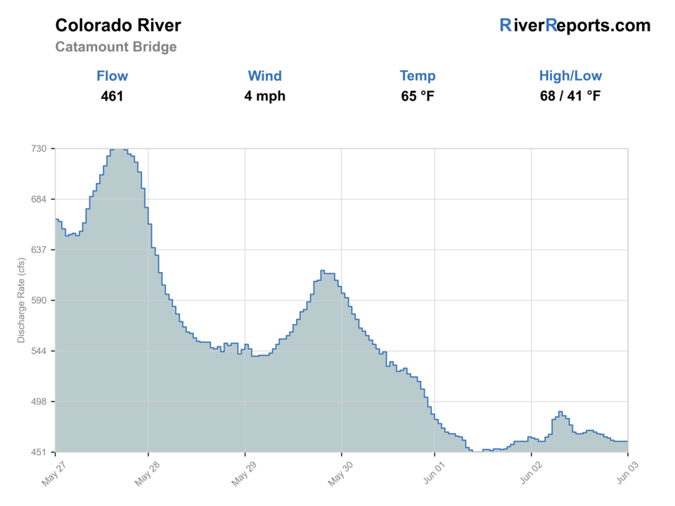
USGS flow
461 cfs
Current trend: flow stable, so weather, temperature, and access checks drive the next change.
More planning details: flies, flow bands, and live source checks
Fish it today
Start here
Choose one anchor section before loading the truck: Pumphouse when you want the classic public launch and upstream feel, State Bridge when you want a downstream shuttle target, or Catamount when you want to key the day off the lower part of this middle-river corridor. Build the flies and shuttle around that decision instead of around a generic Colorado River idea.
Best flow clue
Use the Catamount trend more than any single target number. Stable or slowly dropping flows are the clearest fit for both floats and edge wading, while high runoff, abrupt changes, or late-summer warmth should move you toward a backup river or a shorter bank-only plan.
Skip trigger
Skip the trip when runoff or weather makes a float feel reactive instead of planned, when ramp or shuttle logistics are unresolved, when late-summer water temperatures look hard on trout, or when every public access point is already operating at peak recreation pressure.
Flow decision bands
Low but fishable
Low stable middle Colorado water can fish from bars, banks, and softer side water when temperatures and public access are clear.
Best float-and-wade window
Stable or slowly falling Catamount flow with mild weather gives the best mix of boat positioning, streamer banks, nymph runs, and edge wading.
Runoff or pushy water
High runoff or sharp flow jumps should move the plan to a boat-only day with confirmed shuttles or to a different river.
Pressure and heat caution
Warm late-summer water, crowded ramps, and recreation pressure can make a legal day less useful for trout.
USGS flow
461 cfs
Current trend: flow stable, so weather, temperature, and access checks drive the next change.
Live USGS flow
461 cfs / stable
Live NWS forecast
76F / Mostly Sunny
Live water temperature
61F from USGS
No NWS alert flag
No active NWS alert was returned for this forecast point.
Use the Catamount RiverReports and USGS gauges for this middle-river plan.
Separate float access from wade access before choosing flies or timing.
Check seasonal confluence closures and late-summer temperature risk.
Use the upper or lower Colorado pages for Parshall/Kremmling or Glenwood.
Editorial review
How this report is maintained
This middle Colorado report is maintained from current flow, BLM access, regulation, and weather sources so anglers can plan the Pumphouse to Catamount corridor with better float, wade, and crowd-management context.
Byline
BlueStreamFly editorial team
Reviewed by
BlueStreamFly source review
Maintained by
Mountain Brook Run LLC
Last material review
2026-05-31
Report confidence
Good confidence
89/100
Good confidence: RiverReports Catamount chart, USGS 09060799 flow, BLM Pumphouse and State Bridge access sources, CPW Colorado River context, Colorado special-regulation sources, and weather data support the page. Confidence is moderated by broad corridor scope, private banks, shuttles, recreation pressure, runoff, and temperature stress.
Regulations
Colorado special-regulation sources and CPW Colorado River context support the legal-check path.
Access
BLM Pumphouse and State Bridge sources support public launch and access planning, with shuttles, banks, and crowding still needing current checks.
Flow and weather
RiverReports, USGS 09060799, and the National Weather Service point are attached to the route.
Fishing usefulness
The page now separates Pumphouse, State Bridge, and Catamount planning, float logistics, heat, runoff, private access, and backup choices.
Fishability dashboard and source review
2026-05-31 / material content or source review
RiverReports Colorado River at Catamount Bridge chart, USGS 09060799 flow data, BLM Pumphouse and State Bridge access information, Colorado Parks and Wildlife Colorado River context, Colorado special-regulation sources, and the National Weather Service point were checked before updating the current fishability guidance.
2026-05-31
Updated Colorado River Middle Colorado with Catamount trend guidance, Pumphouse, State Bridge, and Catamount access cards, float and shuttle cautions, backup cues, stable fishability SEO, and confidence signals.
2026-05-29
Added a page-specific report-confidence meter for Middle Colorado flow, Pumphouse and State Bridge access, regulation checks, weather, float logistics, and warm-water planning.
2026-05-28
Added large-river trip-fit guidance, float-versus-wade framing, Catamount trend planning, BLM access nuance, pressure timing, backup-water suggestions, and stronger editorial review signals after source review.
Angler planning edge
Local details that change the plan
Best for
Anglers planning a true large-river day where access, shuttle, and water temperature matter as much as fly choice, Mixed float or targeted-wade trips through the Pumphouse, Radium, State Bridge, and Catamount corridor, Bank-oriented streamer, nymph, and dry-dropper days during stable medium flows, Groups willing to choose one corridor objective instead of trying to sample every famous launch in a single day
Wade or float
Treat the middle Colorado as a mixed float-or-wade page with a float bias. Wading can be worthwhile on bars and softer side water, but the river's size, boat-ramp network, and long public corridor often make a shuttle plan the more useful default.
Best flows
Use the Catamount trend more than any single target number. Stable or slowly dropping flows are the clearest fit for both floats and edge wading, while high runoff, abrupt changes, or late-summer warmth should move you toward a backup river or a shorter bank-only plan.
When to skip
Skip the trip when runoff or weather makes a float feel reactive instead of planned, when ramp or shuttle logistics are unresolved, when late-summer water temperatures look hard on trout, or when every public access point is already operating at peak recreation pressure.
Local plan
Choose one anchor section before loading the truck: Pumphouse when you want the classic public launch and upstream feel, State Bridge when you want a downstream shuttle target, or Catamount when you want to key the day off the lower part of this middle-river corridor. Build the flies and shuttle around that decision instead of around a generic Colorado River idea.
Pressure
The Pumphouse to State Bridge segment is one of the most heavily used public stretches on the river, and BLM notes especially heavy use there. Early launches, weekday floats, and a willingness to fish below the obvious parade water usually matter more than squeezing into the first famous ramp lot.
Access nuance
Middle Colorado access is strong but not unlimited. BLM ramps and fee sites make public entry easier, yet the river still mixes public launches with private-bank gaps, so a good plan starts with the exact ramp, takeout, and bank expectations rather than assuming every bend is open to step out and fish.
Backup water
If the middle Colorado is too warm, too busy, or too pushy, pivot to the upper Colorado for a different public-river day or to the Blue River if you need a colder tailwater backup with a more wade-focused plan.
About the river
Setting, character, and why it fishes the way it does.
The middle Colorado corridor links famous public access points such as Pumphouse, Radium, State Bridge, and Catamount.
It is big enough that float logistics and safety are part of the fishing report, not side details.
This page is separate from the upper Parshall/Kremmling reach and the Glenwood-area lower river so the flow and access advice stays useful.
Target species
Brown trout
A core target around banks, shelves, riffles, and streamer structure.
Rainbow trout
Important in riffles and runs when water temperature supports trout activity.
Mountain whitefish
Common in nymphing water and part of the coldwater community.
Warmwater species context
Lower and warmer sections can include nonnative warmwater species, so check CPW rules before harvest.
Reading the water
Low clear flow
Use longer leaders, careful boat positioning, and lighter nymph rigs.
Medium float flow
A good window for bank streamers, dry-droppers, and nymphing from boat or shore.
High runoff
Use professional judgment for floating and avoid unsafe wading.
Warm late summer
Check water temperature and any CPW voluntary or emergency guidance before targeting trout.
Best seasons
Winter
Slow nymphing can work in mild stable windows, but access and ice reduce options.
Spring
BWOs, caddis, and pre-runoff windows can be strong before flows rise.
Summer
Caddis, PMDs, stones, and terrestrials matter when temperatures remain safe.
Fall
Cooler water and streamers often make this a strong big-river season.
Preferred flow source
Colorado River at Catamount Bridge
RiverReports is the preferred chart source when coverage exists. When a matching USGS gauge exists, keep it open as the official backstop for station data and current hydrograph context.
USGS data chart
Official USGS trend
Streamflow over the latest USGS reporting window.
Latest
461 cfs
Jun 3, 4 PM UTC
Weather
River weather report
Weather can change wading safety, road access, water temperature, hatches, and the best time of day to fish.
Live forecast loads as you reach this section
This keeps the report fast while still using the official National Weather Service forecast point.
Hatches and flies
Hatch chart and fly picks
Winter
Midges, small baetis
Zebra midge, RS2, small pheasant tail
Spring
BWOs, caddis, stones
BWO emerger, caddis pupa, stonefly nymph, soft hackle
Summer
Caddis, PMDs, golden stones, terrestrials
Elk hair caddis, PMD, stimulator, chubby, hopper
Fall
BWOs, midges, October caddis
BWO dry, RS2, October caddis, streamer
Nymphs
Stonefly, caddis pupa, pheasant tail, perdigon, worm
Use through riffles, drop-offs, and boat-side seams.
Dry-droppers
Chubby, hopper, stimulator, tungsten dropper
Use along banks and softer seams during summer and fall.
Streamers
Sculpin, leech, bugger, baitfish
Use from a boat, on cloudy days, or along deeper bank structure.
Dry flies
BWO, PMD, caddis, October caddis, ant
Use during visible hatch activity or on slow banks.
Tactics
How to fish it
Choose float or wade access before choosing a fly plan.
Use the Catamount gauge for this middle-river page.
Work banks and current breaks from a boat during medium flows.
Stay off private banks unless access is clearly public.
Check temperature before late-summer catch-and-release trout fishing.
Rigging
Rod, leader, and setup notes
A 9-foot 5-weight covers dries and nymphs.
Use a 6-weight for streamers, wind, or boat work.
Carry 3X to 6X for mixed large-river rigs.
Bring heavy nymphing weight and light dry-fly leaders.
Wear a PFD when floating and use a wading staff when wading.
Access
Access and planning notes
Pumphouse Recreation Area
Classic public launchWade / float / trail
BLM / boat / bank / wade
When to pick it
Start here when launch logistics, flow, and weather support a full middle-river plan.
Caution
Crowding, ramps, and shuttle timing can be the limiting factor.
State Bridge Recreation Site
Downstream shuttle anchorWade / float / trail
BLM / ramp / bank
When to pick it
Use it when your float or bank plan is built around the lower part of the corridor.
Caution
Private banks and takeout timing need current confirmation.
Catamount Bridge gauge area
Trend and lower-corridor checkWade / float / trail
Gauge / access scout / float
When to pick it
Pick it when you need a current lower-corridor read before choosing reach and method.
Caution
One gauge does not describe every side channel or wade edge.
Float logistics are part of the fishing plan.
Public access does not mean both banks are public.
Late-summer temperature stress can shorten ethical trout windows.
Seasonal tributary closure language should be checked before fishing near confluences.
Regulations
Check before fishing
CPW lists Colorado River regulations and seasonal closure details by reach. Verify the exact Pumphouse, State Bridge, Catamount, and downstream section rules before fishing.
Primary base
Kremmling, Radium, State Bridge, or Eagle County
Best day style
BLM float sites, boat ramps, wade pockets, and private-land gaps
Check first
Flow, ramps, float logistics, seasonal closures, and water temperature
Safety
Large water, boat traffic, canyon weather, warm water, and private banks
Gear
Helpful gear for this water
PFD for floats
Floating this water requires normal big-river safety gear.
Thermometer
Important in warm low-water periods.
Streamer line or leader
Useful for banks, shelves, and cloudy days.
Wading staff
Helpful on cobble bars and pushy riffles.
Nearby water
Other water to research
Backup logic
High water
Use a qualified boat plan, compare the upper Colorado or Blue River, or wait for the Catamount trend to fall.
Heat
Check water temperature and switch to colder water when trout handling is questionable.
Storms or stain
Delay long floats until side inflows, lightning risk, and visibility settle.
Access issue
Use BLM-listed access points and confirmed shuttles; choose another river if ramps or private boundaries are unclear.
Colorado River
Upper Colorado report for Parshall, Williams Fork, and Kremmling.
Colorado River Lower Colorado
Lower page for Glenwood Canyon and Glenwood Springs.
Blue River
A cold tailwater tributary when the mainstem is too warm or high.
FAQ
Fast answers
Is Colorado River Middle Colorado fishable today?
Colorado River Middle Colorado looks very fishable right now. The live score is 96/100, based on current flow, weather, public alerts, and the report's planning context. Recheck the linked gauge and forecast before leaving because conditions can change quickly after rain, heat, access changes, or flow swings.
What flow is best for Colorado River Middle Colorado?
Use the Catamount trend more than any single target number. Stable or slowly dropping flows are the clearest fit for both floats and edge wading, while high runoff, abrupt changes, or late-summer warmth should move you toward a backup river or a shorter bank-only plan.
When should I skip Colorado River Middle Colorado?
Skip the trip when runoff or weather makes a float feel reactive instead of planned, when ramp or shuttle logistics are unresolved, when late-summer water temperatures look hard on trout, or when every public access point is already operating at peak recreation pressure.
Is Colorado River Middle Colorado safe to wade right now?
The fishability score is not a wading guarantee. Wade only where your chosen access has safe edges, clear footing, legal entry, and no forced crossings; high, rising, stained, or storm-affected water should be treated conservatively.
What does Middle Colorado mean here?
This page is scoped to the Pumphouse, Radium, State Bridge, and Catamount planning corridor.
Should I float or wade?
Both can work, but access, flows, and private banks make that decision reach-specific.
Which gauge should I use?
Use the RiverReports and USGS Catamount Bridge flow for this middle-river page.
What is the main summer risk?
Warm water and low flows can stress trout, so carry a thermometer and check CPW guidance.
Sources
Source set for this report
Reviewed 2026-05-31