
Colorado / West
Colorado River
An upper Colorado River report for Parshall, Williams Fork, Kremmling, flow checks, trout tactics, seasonal closures, and access planning.
Image: Colorado River downstream of Glen Canyon Dam, Page, Arizona - April 2026 / CC BY-SA 4.0 / Christian DavidFishability now: Colorado River fishability today
GreatData confidence: High96/100
Fishable now because the live gauge is stable, weather is mild, and no public alert is active.
Flow observed
4:15 PM UTC
Weather observed
5:00 PM UTC
Score calculated
5:25 PM UTC
Why this rating
Flow
Water temperature
Public alerts
Next 6-12 hours
Hold
Stable live data supports staying with the plan, but recheck the gauge and forecast before leaving.
USGS flow
281 cfs
Current trend: flow stable, so weather, temperature, and access checks drive the next change.
More planning details: flies, flow bands, and live source checks
Fish it today
Start here
Choose the reach before choosing flies: Parshall and Williams Fork context for upper access decisions, Kremmling for the main gauge read, and Radium only when you are intentionally shifting toward the middle-river style of water.
Best flow clue
Use the RiverReports Parshall chart and USGS Kremmling station together. Stable or slowly falling flows are the easiest trout-fishing window; high runoff should narrow the plan to safe edges or a boat day, while low warm water should make temperature checks the first decision.
Skip trigger
Skip the upper Colorado when runoff makes crossings unsafe, when late-day temperatures are stressful, when seasonal closure details are not clear for the exact reach, or when your chosen public access would force trespass or crowding.
Flow decision bands
Low but fishable
Low stable upper Colorado water can fish when temperatures are safe and legal public access is confirmed.
Best upper-river window
Stable or slowly falling Parshall and Kremmling trend with mild weather gives the broadest nymph, dry-dropper, and streamer options.
Runoff or float-safety caution
High runoff should move wade plans to safe edges or a boat plan with confirmed ramps and shuttles.
Warm low-water caution
Late-day temperatures, seasonal closures, and private-bank gaps can override a good-looking flow.
USGS flow
281 cfs
Current trend: flow stable, so weather, temperature, and access checks drive the next change.
Live USGS flow
281 cfs / stable
Live NWS forecast
69F / Mostly Sunny
Live water temperature
61F from USGS
No NWS alert flag
No active NWS alert was returned for this forecast point.
Use RiverReports near Parshall and USGS 09058000 for upper-river flow context.
Plan around hatches, runoff, late-summer temperatures, and seasonal closures.
Respect private land; public access is not continuous along the river.
Use the middle or lower Colorado pages for State Bridge, Catamount, Glenwood, or downstream planning.
Editorial review
How this report is maintained
This upper Colorado River report is maintained from RiverReports and USGS flow data, Colorado regulation sources, public-access references, weather checks, and practical river-planning guidance. Review dates change only after material source review or content improvements.
Byline
BlueStreamFly editorial team
Reviewed by
BlueStreamFly source review
Maintained by
Mountain Brook Run LLC
Last material review
2026-05-31
Report confidence
Good confidence
89/100
Good confidence: RiverReports Parshall chart, USGS Kremmling flow, CPW Colorado River context, Colorado special-regulation sources, BLM Radium access information, and weather data support the page. Confidence is moderated by broad upper-river scope, private-land gaps, seasonal closures, float logistics, runoff, and temperature stress.
Regulations
Colorado special-regulation sources and CPW Colorado River context support the legal-check path.
Access
BLM Radium and CPW river context support public-access planning, but private banks, ramps, and exact reaches still need current confirmation.
Flow and weather
RiverReports, USGS 09058000, and the National Weather Service point are attached to the route.
Fishing usefulness
The page now separates upper-river wade planning, Kremmling trend use, float logistics, private access, temperature restraint, and backup choices.
Fishability dashboard and source review
2026-05-31 / material content or source review
RiverReports Colorado River near Parshall chart, USGS Colorado River near Kremmling flow data, Colorado Parks and Wildlife Colorado River context, Colorado special-regulation sources, BLM Radium Recreation Area access information, and the National Weather Service point were checked before updating the current fishability guidance.
2026-05-31
Updated Colorado River with Parshall and Kremmling flow guidance, wade/float access cards, seasonal and temperature cautions, backup cues, stable fishability SEO, and confidence signals.
2026-05-28
Added upper-river trip-fit guidance, wade-versus-float framing, temperature and closure skip cues, private-access nuance, backup-water suggestions, editorial review signals, and a page-specific report-confidence meter after source review.
2026-05-24
Initial source-reviewed report published with flows, weather, hatches, flies, tactics, access, regulations, and FAQs.
Angler planning edge
Local details that change the plan
Best for
Anglers planning the upper Colorado around Parshall, Williams Fork, Hot Sulphur Springs, and Kremmling, Nymph, streamer, dry-dropper, and hatch-match days when flows are stable and temperatures are trout-safe, Trips where private-land gaps, seasonal closures, and float traffic need to be checked before leaving town, Anglers comparing a broad western trout river against smaller nearby tailwater or headwaters options
Wade or float
Treat this as a mixed wade-and-float planning page. Wade only from legal public access and avoid assuming every road-visible bank is open; float plans need ramp, shuttle, weather, and private-boundary checks before the day starts.
Best flows
Use the RiverReports Parshall chart and USGS Kremmling station together. Stable or slowly falling flows are the easiest trout-fishing window; high runoff should narrow the plan to safe edges or a boat day, while low warm water should make temperature checks the first decision.
When to skip
Skip the upper Colorado when runoff makes crossings unsafe, when late-day temperatures are stressful, when seasonal closure details are not clear for the exact reach, or when your chosen public access would force trespass or crowding.
Local plan
Choose the reach before choosing flies: Parshall and Williams Fork context for upper access decisions, Kremmling for the main gauge read, and Radium only when you are intentionally shifting toward the middle-river style of water.
Pressure
The easiest public parcels, bridge areas, and float access points draw the most weekend attention. Early starts, a defined reach, and a willingness to walk past the first visible bend usually help more than changing flies constantly.
Access nuance
Public access is not continuous. Use signed access, BLM information, and CPW reach rules, and treat fences, ranch roads, and unmarked banks as private unless an official access source says otherwise.
Backup water
If the upper Colorado is high, warm, crowded, or restricted, compare the Blue River for a technical tailwater-style day, the Williams Fork for a tributary option, or the Big Laramie River for a smaller headwaters plan after checking current rules.
About the river
Setting, character, and why it fishes the way it does.
The Colorado River starts high in Rocky Mountain country and becomes a broad trout river through Grand County.
This page focuses on the upper Colorado around Parshall, the Williams Fork area, and Kremmling rather than the entire river across the state.
The reach combines quality trout water, private ranch boundaries, float traffic, and regulation details that change by segment.
Target species
Brown trout
A primary target around banks, riffles, buckets, and streamer water.
Rainbow trout
Important in riffles and runs where cold water and habitat line up.
Cutthroat trout context
Part of the broader upper Colorado story, but exact target guidance should stay reach-specific.
Mountain whitefish
Often part of nymphing bycatch and a good sign of coldwater habitat.
Reading the water
Low and clear
Use longer leaders, smaller flies, and careful wading around visible fish.
Stable medium flow
A flexible nymph, dry-dropper, streamer, and hatch-matching window.
High runoff
Focus on safe banks and inside edges only if clarity allows; avoid hard crossings.
Warm late summer
Check temperature, fish early if safe, and stop targeting trout when handling stress is likely.
Best seasons
Winter
Midges and small nymphs can work on mild days, but ice and low sun limit reach choice.
Spring
BWOs and early caddis can fish before runoff; snowmelt then controls safety and clarity.
Summer
Caddis, PMDs, stones, and terrestrials can be strong when water temperatures stay safe.
Fall
Cooler water, BWOs, streamers, and lighter float traffic can improve the plan.
Preferred flow source
Colorado River near Parshall below Williams Fork
RiverReports is the preferred chart source when coverage exists. When a matching USGS gauge exists, keep it open as the official backstop for station data and current hydrograph context.
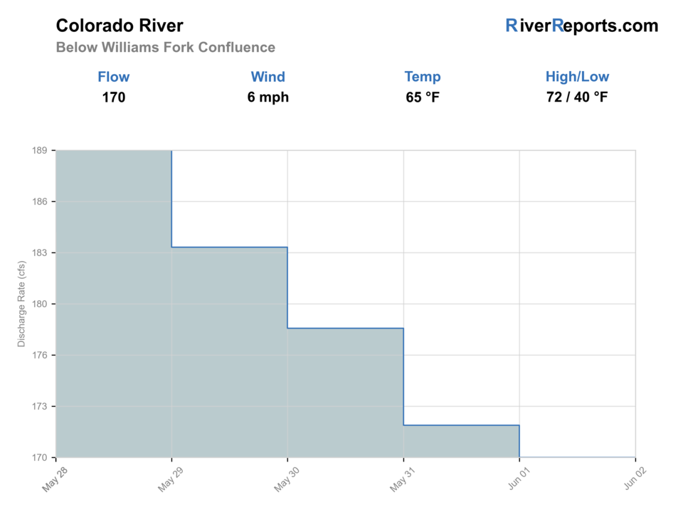
USGS data chart
Official USGS trend
Streamflow over the latest USGS reporting window.
Latest
281 cfs
Jun 3, 4 PM UTC
Weather
River weather report
Weather can change wading safety, road access, water temperature, hatches, and the best time of day to fish.
Live forecast loads as you reach this section
This keeps the report fast while still using the official National Weather Service forecast point.
Hatches and flies
Hatch chart and fly picks
Winter
Midges, small baetis
Zebra midge, RS2, black beauty, small pheasant tail
Spring
BWOs, caddis, stones
BWO emerger, caddis pupa, stonefly nymph, hare's ear
Summer
Caddis, PMDs, golden stones, terrestrials
Elk hair caddis, PMD, stimulator, ant, hopper
Fall
BWOs, midges, October caddis
BWO dry, RS2, October caddis, streamer
Nymphs
Stonefly, pheasant tail, hare's ear, perdigon, caddis pupa
Use through riffles, runs, and buckets when fish are not rising.
Dry flies
BWO, PMD, caddis, stimulator, ant, hopper
Use during visible hatches or terrestrial bankside windows.
Streamers
Sculpin, leech, bugger, baitfish
Use around higher flows, low light, and deeper bank structure.
Dry-droppers
Chubby, hopper, stimulator, tungsten dropper
Use to cover mixed-depth riffles and banks in summer and fall.
Tactics
How to fish it
Choose a named reach before deciding which gauge applies.
Fish banks and soft inside seams during higher flows.
Use nymph rigs in riffles before switching to dries during hatch activity.
Respect private land and avoid assuming road-visible water is public.
Carry a thermometer in late summer.
Rigging
Rod, leader, and setup notes
A 9-foot 5-weight is the standard upper Colorado trout rod.
Use a 6-weight for streamers, wind, or float fishing.
Carry 3X to 6X to switch between streamers, nymphs, and dries.
Bring enough weight for deep runs and lighter options for shallow riffles.
Use a wading staff on pushy flows and cobble bars.
Access
Access and planning notes
Parshall and Williams Fork context
Upper access and flow decisionWade / float / trail
Wade / bank / map check
When to pick it
Use it when the upper trend is stable and public access is confirmed.
Caution
Private-land gaps and seasonal rules matter before stepping in.
Kremmling gauge context
Main river trend checkWade / float / trail
Gauge / float / wade scout
When to pick it
Start here when comparing wade safety and float feasibility.
Caution
A main gauge does not describe every side channel or private bank.
Radium Recreation Area
Float and public access anchorWade / float / trail
BLM / boat / bank
When to pick it
Pick it when intentionally shifting toward a broader middle-river style day.
Caution
Ramp, shuttle, weather, and flow checks still drive safety.
This page is upper Colorado; use separate pages for State Bridge/Catamount and Glenwood.
Public access is broken by private land.
Seasonal closures near tributaries may apply in parts of the broader Colorado River corridor.
Late-summer temperature stress can make ethical fishing windows short.
Regulations
Check before fishing
CPW lists Colorado River special regulations and seasonal closure details by reach. Verify the exact upper Colorado section, dates, and tributary closures before fishing.
Primary base
Kremmling, Parshall, or Hot Sulphur Springs
Best day style
Roadside, public parcels, float access nearby, and private-land gaps
Check first
Flow, water temperature, seasonal closures, and private-property boundaries
Safety
Runoff, cold water, boat traffic, warm late-summer water, and storms
Gear
Helpful gear for this water
Thermometer
Important during summer and low-flow periods.
Wading staff
Helpful on cobble, pushy riffles, and changing flows.
Nymph and streamer boxes
The river can shift from deep nymphing to bank streamers in one day.
Sun and wind layers
Open valley weather changes quickly.
Nearby water
Other water to research
Backup logic
High water
Use a confirmed boat plan, compare the Blue River, or wait for runoff to settle.
Heat
Check water temperature first and stop trout pressure in warm late-day windows.
Storms or stain
Let tributary color and flow settle before committing to a long float or wade.
Access issue
Use BLM or clearly signed public access; move to Blue River or Williams Fork if private boundaries are unclear.
Colorado River Middle Colorado
Use this for Pumphouse, State Bridge, Catamount, and downstream float planning.
Blue River
A technical tailwater tributary option near Silverthorne.
Big Laramie River
A remote Colorado headwaters alternative when you want smaller water.
FAQ
Fast answers
Is Colorado River fishable today?
Colorado River looks very fishable right now. The live score is 96/100, based on current flow, weather, public alerts, and the report's planning context. Recheck the linked gauge and forecast before leaving because conditions can change quickly after rain, heat, access changes, or flow swings.
What flow is best for Colorado River?
Use the RiverReports Parshall chart and USGS Kremmling station together. Stable or slowly falling flows are the easiest trout-fishing window; high runoff should narrow the plan to safe edges or a boat day, while low warm water should make temperature checks the first decision.
When should I skip Colorado River?
Skip the upper Colorado when runoff makes crossings unsafe, when late-day temperatures are stressful, when seasonal closure details are not clear for the exact reach, or when your chosen public access would force trespass or crowding.
Is Colorado River safe to wade right now?
The fishability score is not a wading guarantee. Wade only where your chosen access has safe edges, clear footing, legal entry, and no forced crossings; high, rising, stained, or storm-affected water should be treated conservatively.
What reach does this Colorado River page cover?
It covers the upper Colorado around Parshall, Williams Fork, and Kremmling. Use the middle and lower pages for downstream reaches.
What flow source should I use?
Use the RiverReports Parshall/Williams Fork chart and USGS 09058000 near Kremmling for upper-river context.
Is the upper Colorado good for dry flies?
Yes when hatches or terrestrial windows are active, but nymphs and streamers are often more reliable outside those windows.
When should I avoid fishing?
Avoid unsafe runoff, warm water, seasonal closure conflicts, and muddy storm pulses.
Sources
Source set for this report
Reviewed 2026-05-31