
Colorado / West
Roaring Fork River
A Roaring Fork Valley report for Aspen, Basalt, Carbondale, and Glenwood Springs, with flows, public access, hatches, tactics, and regulation checks.
Image: Roaring Fork River in Basalt, Colorado / CC BY 4.0 / Jeffrey BeallFishability now: Roaring Fork River fishability today
GoodData confidence: High80/100
Fishable now because Glenwood Springs gauge is rising, weather is mild, and no public alert is active.
Flow observed
4:45 PM UTC
Weather observed
4:00 PM UTC
Score calculated
5:23 PM UTC
Why this rating
Flow
Water temperature
Public alerts
Next 6-12 hours
Watch
Recheck within the next few hours; rising water or active weather can change clarity and wading quickly.
USGS flow
1,570 cfs
Current trend: flow rising, rating can drop quickly if clarity or wading safety deteriorates.
More planning details: flies, flow bands, and live source checks
Fish it today
Start here
Choose the valley section before you leave town: upper access for clearer wade water, Basalt and Carbondale for mixed bank-and-drift options, or Glenwood-side lower river only when flows, temperature, and access all support a larger-water plan.
Best flow clue
Use the Glenwood trend as the lower-river anchor and adjust upstream from there. Stable medium flow is the most forgiving for mixed tactics; sharp runoff or warm late-summer conditions should move you toward cooler upper reaches or a different river.
Skip trigger
Skip the lower Roaring Fork when warm afternoon temperatures threaten trout handling, when runoff removes wading margin, when special-rule boundaries are unclear, or when heavy boat traffic keeps you from fishing the water you actually want.
Flow decision bands
Low but fishable
Low clear Roaring Fork water can fish from safe edges when temperatures stay cool and public access is confirmed.
Best valley window
Stable or slowly falling Glenwood flow with mild weather gives the best wade, float, nymph, streamer, and dry-fly signal.
Runoff or pushy water
High runoff, fast bank water, or poor clarity should move wade plans to safer edges or another valley stream.
Warm lower-river caution
Hot afternoons and low late-season water should shorten trout handling, especially lower in the valley.
USGS flow
1,570 cfs
Current trend: flow rising, rating can drop quickly if clarity or wading safety deteriorates.
Live USGS flow
1,570 cfs / rising about 23%
Live NWS forecast
60F / Mostly Sunny
Live water temperature
52F from USGS
No NWS alert flag
No active NWS alert was returned for this forecast point.
RiverReports and USGS 09085000 give a strong lower-river flow reference at Glenwood Springs.
CPW identifies important special rules above and below Woody Creek and notes rainbow and brown trout.
Gold Medal context applies in parts of the Roaring Fork, but each reach still needs a current rule check.
Clean, drain, and dry gear, especially in the lower river where ANS concerns have been flagged.
Editorial review
How this report is maintained
This report starts with official regulation, access, flow, weather, and public-river sources, then adds practical planning guidance for anglers.
Byline
BlueStreamFly editorial desk
Reviewed by
BlueStreamFly source review
Maintained by
BlueStreamFly
Last material review
2026-05-31
Report confidence
Good confidence
89/100
Good confidence: RiverReports, USGS 09085000 flow, Colorado regulation sources, BLM Wingo Junction, Pitkin County access context, CPW river information, and weather data support the page. Confidence is moderated by broad corridor scope, section-specific rules, private banks, runoff swings, float logistics, and warm lower-river afternoons.
Regulations
Colorado Parks and Wildlife Roaring Fork and special-regulation sources support the legal-check path before choosing a valley section.
Access
BLM Wingo Junction and Pitkin County Jaffee Park sources provide strong public-access anchors, with exact banks, launches, and parking still needing day-of checks.
Flow and weather
RiverReports, USGS 09085000, and the National Weather Service point are attached to the route.
Fishing usefulness
The page now separates upper, middle, and lower Roaring Fork planning, runoff, warm-water restraint, float versus wade choices, access boundaries, and backup options.
Fishability dashboard and source review
2026-05-31 / material content or source review
RiverReports Roaring Fork at Glenwood Springs chart, USGS 09085000 flow data, Colorado Parks and Wildlife Roaring Fork and special-regulation sources, BLM Wingo Junction access, Pitkin County Jaffee Park context, and the National Weather Service point were checked before updating the current fishability guidance.
2026-05-31
Updated Roaring Fork River with Glenwood trend guidance, upper-valley and lower-valley access cards, warm-water and runoff cautions, backup cues, stable fishability SEO, and confidence signals.
2026-05-29
Added a page-specific report-confidence meter for Roaring Fork flow, regulation boundaries, public access anchors, weather, and upper-versus-lower valley trip planning.
2026-05-28
Added editorial review signals, a public verification note, and original angler-planning guidance covering reach selection, wade-versus-float framing, warm-water skip triggers, pressure timing, and better backup-water choices after source review.
Angler planning edge
Local details that change the plan
Best for
Anglers who want one page to sort upper-valley wading from lower-valley float planning, Summer and fall trips where multiple public access points let you adjust reach by clarity and pressure, Nymph, dry-dropper, and streamer days built around one broad western Colorado trout corridor, People willing to leave the lower river when water temperatures or traffic turn the day against them
Wade or float
Treat the Roaring Fork as both, but not at the same time. Upper and mid-valley access points suit classic wade fishing, while the lower river around Carbondale and Glenwood is often better approached as a float-oriented or bank-selective plan.
Best flows
Use the Glenwood trend as the lower-river anchor and adjust upstream from there. Stable medium flow is the most forgiving for mixed tactics; sharp runoff or warm late-summer conditions should move you toward cooler upper reaches or a different river.
When to skip
Skip the lower Roaring Fork when warm afternoon temperatures threaten trout handling, when runoff removes wading margin, when special-rule boundaries are unclear, or when heavy boat traffic keeps you from fishing the water you actually want.
Local plan
Choose the valley section before you leave town: upper access for clearer wade water, Basalt and Carbondale for mixed bank-and-drift options, or Glenwood-side lower river only when flows, temperature, and access all support a larger-water plan.
Pressure
Easy Basalt, Carbondale, and lower-valley pullouts collect pressure quickly, especially once summer flows settle. A dawn start, a less-obvious access point, or a willingness to fish above or below the first famous run often matters more than changing fly patterns.
Access nuance
Public access is good but not continuous, and special rules change by section. A floatable-looking reach may still demand different gear, takeouts, or legal assumptions than the upper wade water, so match the access source to the exact section.
Backup water
If the main Roaring Fork is too warm, crowded, or pushy, pivot to the colder Fryingpan for technical tailwater fishing or to the Eagle River when you want another freestone-style valley option.
About the river
Setting, character, and why it fishes the way it does.
The Roaring Fork flows from the Aspen area through Basalt, Carbondale, and Glenwood Springs before joining the Colorado River.
CPW describes the reach upstream of the Fryingpan as a quality wild brown and rainbow trout opportunity with public access points for shore, wade, and float anglers.
Below Basalt and Carbondale, the river gets bigger and more float-oriented while still offering productive wade access where public entry is clear.
This page treats the river as a connected valley fishery, but it separates upper technical water, Basalt transition water, and lower float water in the planning notes.
Target species
Brown trout
A major Roaring Fork target, especially near banks, undercut structure, and fall streamer water.
Rainbow trout
CPW lists rainbow trout and notes quality fish in the upper river above the Fryingpan confluence.
Mountain whitefish
Common in western Colorado rivers and a useful indicator of deeper productive runs.
Brook trout
More relevant in colder upper drainage and tributary context than in the lower mainstem.
Reading the water
Runoff
Expect pushy water and limited wading. Fish edges or choose a tailwater alternative when flows are unsafe.
Stable medium flow
This is the most flexible window for nymphs, dry-droppers, dries, and streamers from a boat or bank.
Low clear flow
Use longer leaders, smaller flies, and precise casts in upper and pressured reaches.
Warm lower river
Carry a thermometer near Carbondale and Glenwood during hot weather and shift plans if trout handling risk is high.
Best seasons
Winter
Lower elevation and milder valley weather can create slow but fishable nymphing windows.
Spring
Pre-runoff BWOs and caddis can be good; runoff can make wading unsafe.
Summer
Caddis, PMDs, yellow sallies, terrestrials, and float-bank fishing all matter after runoff settles.
Fall
Cooler water, BWOs, October caddis, and streamer fishing can make a strong season.
Preferred flow source
Roaring Fork River at Glenwood Springs
RiverReports is the preferred chart source when coverage exists. When a matching USGS gauge exists, keep it open as the official backstop for station data and current hydrograph context.
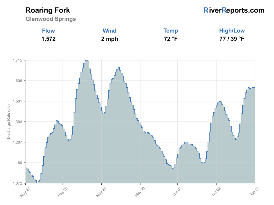
USGS data chart
Official USGS trend
Streamflow over the latest USGS reporting window.
Latest
1,570 cfs
Jun 3, 4 PM UTC
Weather
River weather report
Weather can change wading safety, road access, water temperature, hatches, and the best time of day to fish.
Live forecast loads as you reach this section
This keeps the report fast while still using the official National Weather Service forecast point.
Hatches and flies
Hatch chart and fly picks
Winter
Midges and small olives
Zebra midge, black beauty, RS2, small pheasant tail
Spring
BWOs, caddis, stoneflies
BWO emerger, caddis pupa, Pat's rubber legs, hare's ear
Summer
PMDs, caddis, yellow sallies, terrestrials
PMD cripple, elk hair caddis, yellow sally, ant, hopper
Fall
BWOs, midges, October caddis
BWO dry, zebra midge, October caddis, sculpin streamer
Nymphs
Pheasant tail, hare's ear, perdigon, stonefly nymph, caddis pupa
Use through riffles, buckets, and float-bank seams when no hatch is obvious.
Dry flies
BWO, PMD, caddis, parachute Adams, yellow sally
Use during hatch windows and low-light summer feeding.
Dry-droppers
Chubby, stimulator, hopper, tungsten dropper
Use to cover broken banks, pocket water, and summer float lines.
Streamers
Sculpin, leech, bugger, sparkle minnow
Use in stained water, low light, and deeper banks, especially in fall.
Tactics
How to fish it
Separate upper wade water from lower float water before choosing gear.
Use the Glenwood gauge for lower-river context and smaller upstream gauges if fishing above Basalt.
Adjust weight often because depth changes fast in riffle and bank lines.
Respect private property and posted SWA or county access rules.
Clean, drain, and dry boots, waders, and boats between waters.
Rigging
Rod, leader, and setup notes
A 9-foot 5-weight is the everyday Roaring Fork rod.
Carry a 6-weight for streamers, windy floats, or heavier runoff edges.
Use 4X to 6X for nymphs and dries depending on clarity.
Carry dry-dropper materials, split shot, and indicators for quick depth changes.
Bring a thermometer, especially for lower-river summer fishing.
Access
Access and planning notes
Jaffee Park / upper valley
Gauge-area and upper reach checkWade / float / trail
Park / wade / bank scout
When to pick it
Start here when colder upper-valley water and public access fit a short trout session.
Caution
Upper-valley access still has private edges and fast pocket-water footing.
Basalt to Carbondale corridor
Middle-valley reach choiceWade / float / trail
Wade / float comparison / bank
When to pick it
Use it when the day needs a mix of public access, cooler water, and method flexibility.
Caution
Confirm launch, parking, and public-bank details before assuming a continuous corridor.
Wingo Junction / Glenwood lower river
Lower-valley float and trend checkWade / float / trail
BLM / float / wade edges
When to pick it
Pick it when the Glenwood trend is stable and lower-river temperatures are still responsible for trout fishing.
Caution
Heat, boat traffic, and private banks can override a good-looking graph.
CPW lists special regulation boundaries from Maroon Creek to the upper Woody Creek bridge and from there to the Fryingpan River.
BLM Wingo Junction and CPW SWA pages help with lower-river public access planning.
Pitkin County open-space pages add useful upper-valley access context.
Boat and wade traffic can overlap; communicate clearly and give other anglers space.
Regulations
Check before fishing
Verify current Colorado special regulations before fishing. Artificial-only, catch-and-release, harvest-size rules, and seasonal closures differ by reach.
Primary base
Basalt, Carbondale, or Glenwood Springs, Colorado
Best day style
Town parks, SWA access, BLM river access, and float reaches
Check first
Glenwood flow, CPW special rules, float access, closures, and temperature
Safety
Runoff, boat traffic, slippery cobble, ANS precautions, and warm lower water
Gear
Helpful gear for this water
Thermometer
Important on lower-river summer days and warm afternoons.
Float or wade map
Useful for matching public access, takeouts, and private boundaries.
Streamer rod option
Helpful for lower-river banks, stain, and fall fishing.
Decontamination kit
Clean, drain, and dry gear between Roaring Fork and other waters.
Nearby water
Other water to research
Backup logic
High water
Compare the Fryingpan, Crystal, or smaller upper-valley water instead of forcing pushy Roaring Fork wading.
Heat
Fish early, move higher, or stop trout pressure if lower-valley water warms.
Storms or stain
Let runoff or tributary color settle before committing to a long float or deep wade.
Access issue
Use signed public access such as BLM or county sites; pivot if banks, launches, or parking are unclear.
Fryingpan River
A technical Basalt tailwater when you want colder controlled water.
Colorado River Lower Colorado
The larger river near Glenwood Springs and downstream.
Eagle River
A nearby freestone valley river west of Vail.
FAQ
Fast answers
Is Roaring Fork River fishable today?
Roaring Fork River looks fishable right now. The live score is 80/100, based on current flow, weather, public alerts, and the report's planning context. Recheck the linked gauge and forecast before leaving because conditions can change quickly after rain, heat, access changes, or flow swings.
What flow is best for Roaring Fork River?
Use the Glenwood trend as the lower-river anchor and adjust upstream from there. Stable medium flow is the most forgiving for mixed tactics; sharp runoff or warm late-summer conditions should move you toward cooler upper reaches or a different river.
When should I skip Roaring Fork River?
Skip the lower Roaring Fork when warm afternoon temperatures threaten trout handling, when runoff removes wading margin, when special-rule boundaries are unclear, or when heavy boat traffic keeps you from fishing the water you actually want.
Is Roaring Fork River safe to wade right now?
The fishability score is not a wading guarantee. Wade only where your chosen access has safe edges, clear footing, legal entry, and no forced crossings; high, rising, stained, or storm-affected water should be treated conservatively.
What part of the Roaring Fork does this report cover?
It covers the main valley river from the Aspen area through Basalt, Carbondale, and Glenwood Springs.
Is the Roaring Fork better to float or wade?
Both can work. Upper and public access reaches are more wade-focused, while lower reaches often suit float fishing.
What gauge should I check?
Use RiverReports and USGS 09085000 at Glenwood Springs for lower-river context, and match upstream gauges to your exact reach when possible.
What flies should I bring?
Carry midges, BWOs, caddis, PMDs, yellow sallies, terrestrials, stonefly nymphs, and streamers.
Sources
Source set for this report
Reviewed 2026-05-31