
California / West
Lower Yuba River
A Lower Yuba report focused on Englebright-to-Marysville flow checks, wild trout and steelhead planning, Skwala-to-caddis hatches, and careful access.
Image: Generated regional planning image for Lower Yuba River / BlueStreamFly generated; not exact location / BlueStreamFlyFishability now: Lower Yuba River fishability today
GreatData confidence: High96/100
Fishable now because the live gauge is falling, weather is usable, and no public alert is active.
Flow observed
4:30 PM UTC
Weather observed
5:00 PM UTC
Score calculated
5:25 PM UTC
Why this rating
Flow
Weather
Public alerts
Next 6-12 hours
Improving / hold
A falling gauge and usable weather should keep the next 6-12 hours in play unless tributaries stain or heat builds.
USGS flow
1,190 cfs
Current trend: flow falling, rating likely holding strong unless weather or clarity changes.
More planning details: flies, flow bands, and live source checks
Fish it today
Start here
Pick the access before the flies: verify the current Yuba Water conditions, decide whether Highway 20, Parks Bar, or another known legal access is your anchor, then fish one reach patiently instead of burning time scouting every visible gravel bar on the river.
Best flow clue
Use the Marysville gauge and Yuba Water condition notes as a trend tool, not a magic number. Stable or slowly easing releases fish better than abrupt change, and Yuba Water explicitly warns that flows can change rapidly, so a plan that looked fine at breakfast can become a bad wading idea by midday.
Skip trigger
Skip the trip when release notices suggest rapid change, when warm-weather fish handling is questionable, when the legal access points are already overloaded, or when you would need to guess about private-boundary crossings to reach the water you want.
Flow decision bands
Low but fishable
Lower stable water can support technical trout fishing, but exposed cobble, private boundaries, and heat can still make it a poor human day.
Best wild-trout window
Stable or gently falling Marysville flow, good clarity, mild weather, and a legal access plan create the strongest green light.
Pushy or unsafe
Rising releases, fast cobble runs, or unclear exits should move the plan to banks or another river.
Hatch or salmonid sensitivity
Good conditions still need current CDFW rule checks, redd avoidance, and careful handling.
USGS flow
1,190 cfs
Current trend: flow falling, rating likely holding strong unless weather or clarity changes.
Live USGS flow
1,190 cfs / falling about 14%
Live NWS forecast
75F / Sunny
Water temperature not verified
Heat guidance uses weather and river type unless an official water-temperature value is available.
No NWS alert flag
No active NWS alert was returned for this forecast point.
Use the USGS Marysville gauge and Yuba Water conditions before wading.
Expect wild rainbow trout, steelhead context, and salmon-season sensitivity.
Skwalas, PMDs, caddis, BWOs, and egg/stonefly windows all matter by season.
Respect private land and do not treat every gravel bar as public access.
Editorial review
How this report is maintained
This Lower Yuba report combines current flow, access, weather, and regulation sources with practical wild-trout planning guidance. Public review dates change only after material source review or meaningful content updates.
Byline
BlueStreamFly editorial team
Reviewed by
BlueStreamFly source review
Maintained by
Mountain Brook Run LLC
Last material review
2026-05-31
Report confidence
High confidence
90/100
High confidence: RiverReports, USGS Marysville flow, Yuba Water conditions, CDFW Wild and Heritage Trout sources, regulation/closure pages, and weather data support the page. Confidence is moderated by limited public access, release changes, private boundaries, and heat on exposed cobble.
Regulations
CDFW wild-trout, freshwater regulation, and closure sources support the legal-check path.
Access
Yuba Water, CDFW map context, and access notes support planning, but exact parking, signs, and private edges need current confirmation.
Flow and weather
RiverReports, USGS 11421000, Yuba Water conditions, and the National Weather Service point are attached to the route.
Fishing usefulness
The page now separates Marysville flow, technical access, hatch timing, heat, release changes, and backup river choices.
Fishability dashboard and source review
2026-05-31 / material content or source review
RiverReports, USGS Yuba River near Marysville flow, Yuba Water river conditions and Lower Yuba Accord context, CDFW Wild and Heritage Trout material, CDFW regulation/closure sources, and the National Weather Service point were checked before updating the current-fishability decision layer.
2026-05-31
Updated Lower Yuba River to the current fishability-page standard with Marysville flow guidance, access cards, backup cues, stable fishability SEO, and confidence signals.
2026-05-28
Added best-use fit, access-first local planning, release-trend framing, skip cues for sudden flow changes, pressure timing, backup-water options, stronger editorial review signals, and a page-specific report-confidence meter after source review.
2026-05-24
Initial source-reviewed report published with flows, weather, hatches, flies, tactics, access, regulations, and FAQs.
Angler planning edge
Local details that change the plan
Best for
Experienced wade anglers who want hatch-driven wild-trout fishing on a larger foothill river, Trips built around Skwala, PMD, caddis, and soft-hackle windows rather than blind coverage, Days when stable releases and clear edges make careful nymphing and dry-fly work practical, Anglers willing to solve legal access and crowd management before stepping into the river
Wade or float
Treat the Lower Yuba as a wade-first page, but only at flows that make the edges and exits reasonable. The river can become bank-only very quickly, and this report is more useful for picking safe legal wading windows than for promising an easy float day.
Best flows
Use the Marysville gauge and Yuba Water condition notes as a trend tool, not a magic number. Stable or slowly easing releases fish better than abrupt change, and Yuba Water explicitly warns that flows can change rapidly, so a plan that looked fine at breakfast can become a bad wading idea by midday.
When to skip
Skip the trip when release notices suggest rapid change, when warm-weather fish handling is questionable, when the legal access points are already overloaded, or when you would need to guess about private-boundary crossings to reach the water you want.
Local plan
Pick the access before the flies: verify the current Yuba Water conditions, decide whether Highway 20, Parks Bar, or another known legal access is your anchor, then fish one reach patiently instead of burning time scouting every visible gravel bar on the river.
Pressure
The best-known Lower Yuba access points draw concentrated pressure during Skwala, PMD, and comfortable spring weekends. Early starts, weekday windows, and a willingness to walk farther often matter more than changing bugs every few casts.
Access nuance
The Lower Yuba shows a lot of gravel and side channels, but visible water is not the same thing as legal access. Use official access, respect private boundaries and railroad-related no-go areas, and remember that a safe exit matters as much as the entry point on this river.
Backup water
If the Lower Yuba is too pushy, crowded, or warm, move to the Feather for a bigger lower-river backup or to the North Yuba if you want a smaller freestone day with different wading and hatch expectations.
About the river
Setting, character, and why it fishes the way it does.
The Lower Yuba River flows out of the Sierra foothills toward Marysville and the Feather River system.
Englebright Dam and upstream water management shape the lower river's flow, sediment, and fish habitat, so a gauge check matters even on clear days.
CDFW lists the Lower Yuba in its Wild and Heritage Trout Water program, which is why careful catch-and-release and habitat awareness belong on the page.
Access is one of the biggest planning issues. Some well-known reaches are near bridges or county access, while other banks and bars involve private property or changing boundaries.
Target species
Wild rainbow trout
The main fly target, often feeding in fast riffles, tailouts, side channels, and hatch-driven lanes.
Steelhead
Present as an anadromous and resident-rainbow context. Check current CDFW rules and report-card requirements.
Chinook salmon
Important for the river's ecology. Avoid fishing over spawning salmon or redds.
Suckers and native fish
Part of the lower-river system and a reminder to identify fish before handling or reporting catches.
Reading the water
Low clear flow
Use long leaders, careful approaches, small nymphs, emergers, and low-profile dry flies.
Stable medium flow
The most flexible window for nymphing riffles, swinging soft hackles, and watching for heads.
High release
Wading can become dangerous fast. Focus on safe edges or wait for a lower trend.
Warm afternoon
Check temperature, shorten fights, and shift plans if trout handling becomes stressful.
Best seasons
Winter
Skwala, BWO, stonefly, and egg-pattern windows can matter when flows and rules line up.
Spring
PMDs, caddis, and mayfly nymphs often become core patterns as water warms.
Summer
Early and late windows are better. Watch temperature and recreation pressure.
Fall
Cooler water and salmon activity make etiquette, redd awareness, and current rules important.
Preferred flow source
Yuba River near Marysville
RiverReports is the preferred chart source when coverage exists. When a matching USGS gauge exists, keep it open as the official backstop for station data and current hydrograph context.
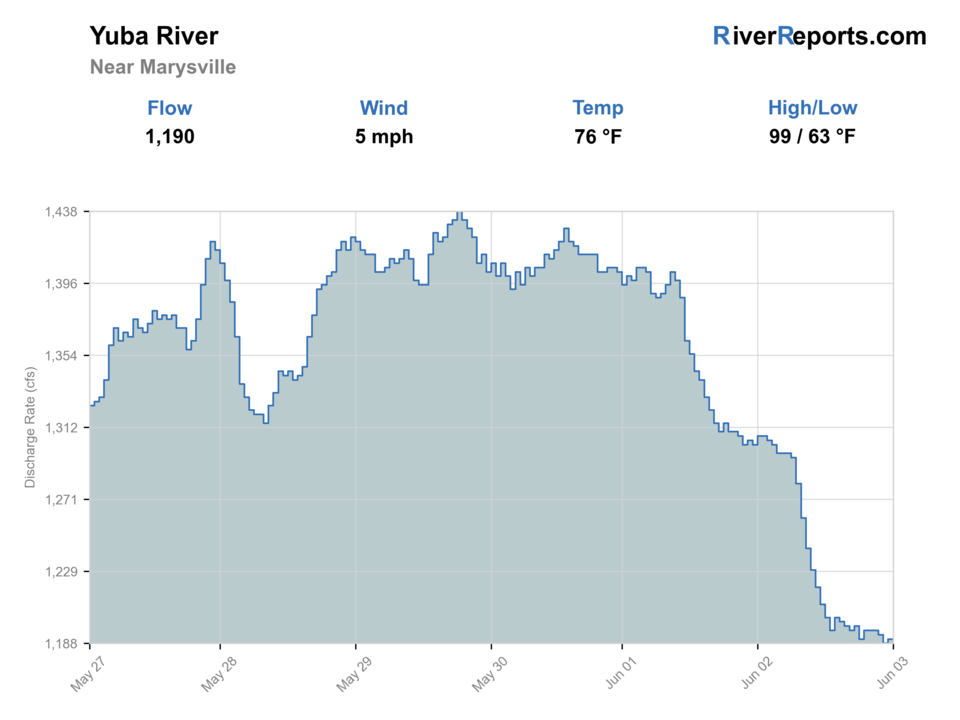
USGS data chart
Official USGS trend
Streamflow over the latest USGS reporting window.
Latest
1,190 cfs
Jun 3, 4 PM UTC
Weather
River weather report
Weather can change wading safety, road access, water temperature, hatches, and the best time of day to fish.
Live forecast loads as you reach this section
This keeps the report fast while still using the official National Weather Service forecast point.
Hatches and flies
Hatch chart and fly picks
Winter
Skwala stones, BWOs, midges
Skwala dry, stonefly nymph, BWO emerger, zebra midge
Spring
PMDs, caddis, March browns, little yellow stones
PMD dry, pheasant tail, caddis pupa, yellow sally nymph
Summer
Caddis, terrestrials, small mayflies
Elk hair caddis, ant, beetle, small mayfly nymph
Fall
BWOs, caddis, salmon-egg context
BWO, soft hackle, egg pattern where legal, small stonefly
Nymphs
Stonefly, pheasant tail, perdigon, PMD nymph, caddis pupa
Use through riffles, seams, and drop-offs when fish are not visibly rising.
Dry flies
Skwala dry, PMD, BWO, elk hair caddis, parachute mayfly
Use when trout hold near soft edges, foam lines, and hatch lanes.
Soft hackles
Partridge and orange, PMD soft hackle, caddis soft hackle
Swing through riffle tails during emergence or when fish flash below the surface.
Streamers
Sculpin, leech, small baitfish, olive bugger
Use in higher or stained water, especially along banks and bucket edges.
Tactics
How to fish it
Check the Marysville gauge before driving and again before wading.
Walk quietly because the clear tailwater can punish sloppy bank movement.
Fish first casts from the bank before stepping into shallow edge water.
Adjust weight and indicator depth often; many Lower Yuba trout feed near the bottom.
Swing soft hackles after nymphing a riffle if bugs are active.
Avoid redds and visible salmon during fall spawning windows.
Rigging
Rod, leader, and setup notes
A 9-foot 5-weight is the best all-around trout rod.
Use a 6-weight for streamers, high wind, or heavier nymph rigs.
Carry 4X to 6X tippet, split shot, indicators, and a dry-dropper setup.
Bring a wading staff and studded boots for slick cobble.
Keep a thermometer and release fish quickly in warm or low water.
Access
Access and planning notes
Highway 20 / Parks Bar context
Classic access checkWade / float / trail
Bank / wade scout
When to pick it
Use it when signs, parking, flow, and wading exits are all clear.
Caution
Well-known does not mean every nearby bar is public or safe.
Marysville gauge reach
Flow referenceWade / float / trail
Lower-river context
When to pick it
Use it to confirm the trend before choosing Englebright-to-Marysville water.
Caution
Gauge context is not a blanket access permission.
County and bridge access
Legal entry planningWade / float / trail
Bridge / bank / short wade
When to pick it
Pick these when public access and current closures are verified.
Caution
Private land, swift cobble, and limited exits are the main risks.
Public access is limited compared with the amount of visible river.
Yuba Water condition notes are useful because minimum-flow and release changes affect safety.
Do not cross fences, railroad property, or private fields to reach gravel bars.
Flows that look manageable from the road can be dangerous once you are on cobble.
Expect other anglers around the best-known access points during hatch windows.
Regulations
Check before fishing
Verify CDFW's current Lower Yuba River regulations, Wild Trout Water notes, steelhead report-card requirements, and emergency notices before fishing.
Primary base
Marysville, Grass Valley, Nevada City, or Yuba City, California
Best day style
Limited public access, bridges, county access, and private-boundary caution
Check first
Marysville flow, CDFW regulations, Yuba Water conditions, access boundaries
Safety
Swift dam-managed flows, slippery cobble, limited exits, private-property edges
Gear
Helpful gear for this water
Studded boots
Lower Yuba cobble and pushy seams make traction a real safety item.
Skwala and PMD box
Seasonal hatch matching is one of the main reasons anglers visit this river.
Long leader material
Clear water and pressured trout often require cleaner presentations.
Access backup plan
Have more than one legal option because parking, flows, and crowds can change the day.
Nearby water
Other water to research
Backup logic
High water
Avoid pushy wading and compare the Feather River, American River, or North Yuba instead.
Heat
Fish early, check temperature, and stop trout pressure when exposed cobble heats up.
Storms or turbidity
Use Yuba Water and the Marysville trend before committing to technical trout lanes.
Access issue
Use signed public access or choose another river rather than stepping through uncertain private ground.
North Yuba River at Goodyears Bar
A colder freestone alternative with canyon access and smaller-water tactics.
Feather River
A nearby anadromous river with hatchery-zone and flow planning complexity.
American River
Another Central Valley tailwater where rules, flows, and urban access shape the trip.
FAQ
Fast answers
Is Lower Yuba River fishable today?
Lower Yuba River looks very fishable right now. The live score is 96/100, based on current flow, weather, public alerts, and the report's planning context. Recheck the linked gauge and forecast before leaving because conditions can change quickly after rain, heat, access changes, or flow swings.
What flow is best for Lower Yuba River?
Use the Marysville gauge and Yuba Water condition notes as a trend tool, not a magic number. Stable or slowly easing releases fish better than abrupt change, and Yuba Water explicitly warns that flows can change rapidly, so a plan that looked fine at breakfast can become a bad wading idea by midday.
When should I skip Lower Yuba River?
Skip the trip when release notices suggest rapid change, when warm-weather fish handling is questionable, when the legal access points are already overloaded, or when you would need to guess about private-boundary crossings to reach the water you want.
Is Lower Yuba River safe to wade right now?
The fishability score is not a wading guarantee. Wade only where your chosen access has safe edges, clear footing, legal entry, and no forced crossings; high, rising, stained, or storm-affected water should be treated conservatively.
What gauge should I use for the Lower Yuba?
Use USGS 11421000, Yuba River near Marysville, along with Yuba Water's current river conditions.
Is the Lower Yuba easy to access?
No. Access is limited and mixed with private land, so verify legal parking and river entry before fishing.
What flies should I bring?
Bring stoneflies, PMDs, caddis, BWOs, midges, soft hackles, and a few streamers.
Is it safe to wade?
Only at appropriate flows and from safe access. The river has slick cobble and can become pushy quickly.
Sources
Source set for this report
Reviewed 2026-05-31